Wildfires and poor air quality continue for the Pacific Northwest, Rockies and extended into the Plains. Severe thunderstorms possible for the northern Plains and upper Midwest on Monday along a frontal boundary. Another boundary will focus showers and thunderstorms for the eastern seaboard with localized heavy rainfall possible. For Alaska, a strong Bering Sea storm will bring winds and rainfall. Read More >
Overview
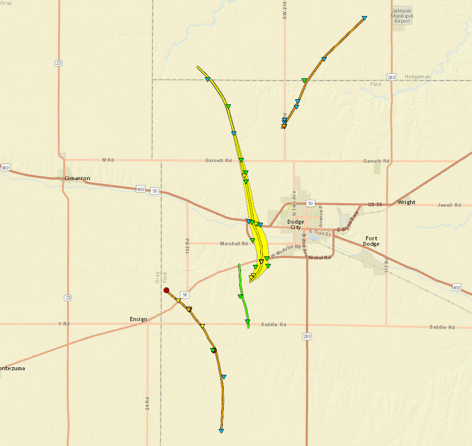
A series of supercells formed during the late afternoon into the early evening hours across portions of western Kansas producing 12 to 15 tornadoes.
One supercell produced numerous cyclic tornadoes starting few miles north of Minneola with the last tornado dissipating about 6 miles south southwest of Jetmore. EF3 damage was produced a few miles east of Ensign were a house was destroyed as well as around 6 miles north of Dodge City. Some notable damage with these tornadoes includes a house that was destroyed just east of Ensign, a semi overturned on US50, numerous homes along highway 50 just west of Dodge City were heaviely damaged (at one home there were two injuries), a large propane tank was reported leaking at 14th and Denim and a building at the landfill north of Dodge City was destroyed.
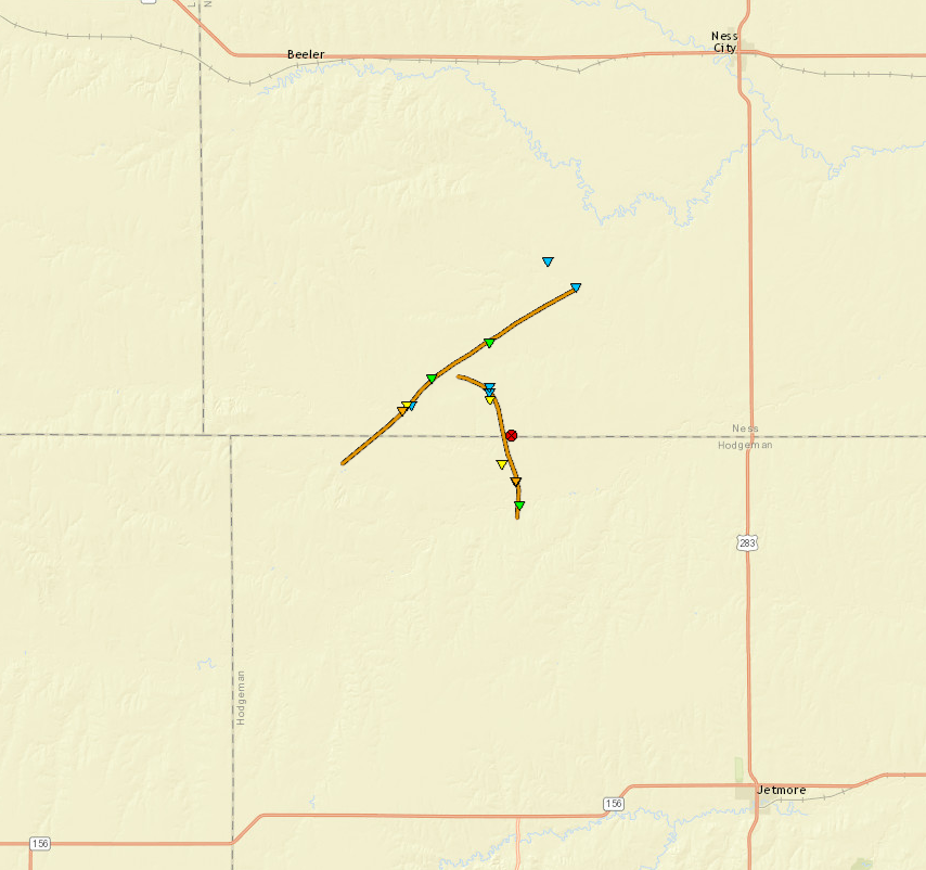
Other tornadoes occured in northwestern Hodgeman and southwestern Ness Counties. EF3 damage was also produced with these tornadoes. Some notable damage from these tornadoes were a home that was destroyed northwest of Jetmore, a stock trailer was blown nearly 3 miles, an oil take was blown over, many electric poles were damaged and destroyed, and a farmstead was destroyed in southwestern Ness County.
A few other tornadoes formed across portions of Edwards county causing damage to two homes south of Lewis. One of these tornadoes eventually produced EF3 damage southeast of Lewis.
Tornadoes:
|
Tornado - North of Minneola to northeast of Ensign
|
||||||||||||||||
|
Tornado - 7 miles west of Ensign to Hyw 56
|
||||||||||||||||
|
Tornado - Hyw 56 to SW 203 Road in Hodgman County
|
||||||||||||||||
|
Tornado - 5 miles north of Dodge City to 6 miles SSW of Jetmore
|
||||||||||||||||
|
Tornado - 7-17 miles southwest of Ness City
|
||||||||||||||||
|
Tornado - 8-13 miles SW of Ness City
|
||||||||||||||||
|
Tornado - 8 miles south of Kinsley
|
||||||||||||||||
|
Tornado - 10 miles SSE of Kinsley
|
||||||||||||||||
|
Tornado - 3 miles south of Lewis
|
||||||||||||||||
The Enhanced Fujita (EF) Scale classifies tornadoes into the following categories:
| EF0 Weak 65-85 mph |
EF1 Moderate 86-110 mph |
EF2 Significant 111-135 mph |
EF3 Severe 136-165 mph |
EF4 Extreme 166-200 mph |
EF5 Catastrophic 200+ mph |
 |
|||||
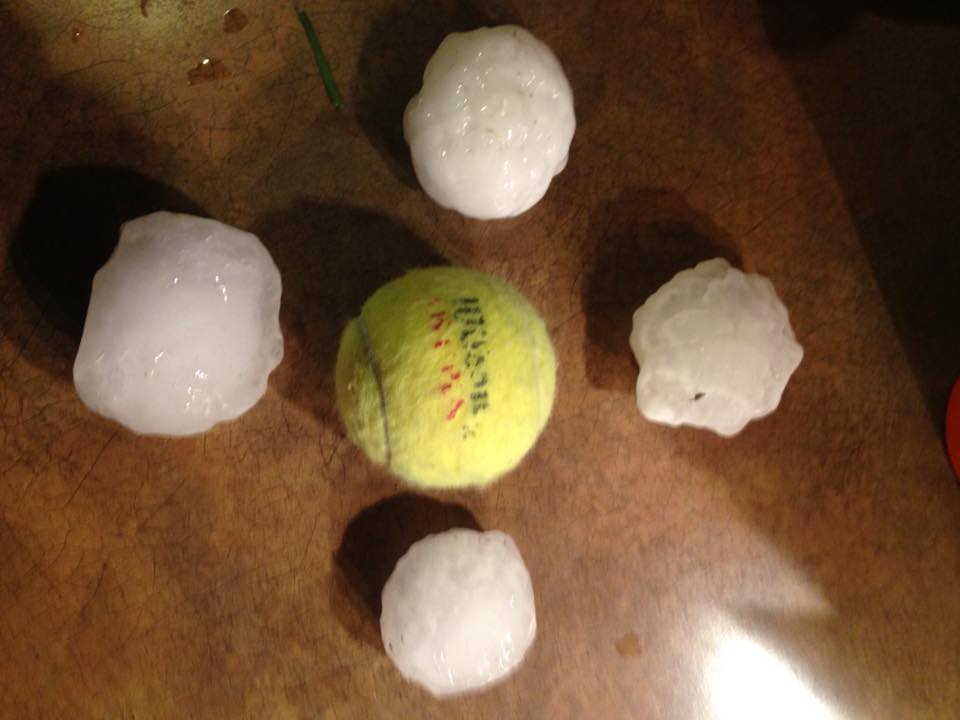
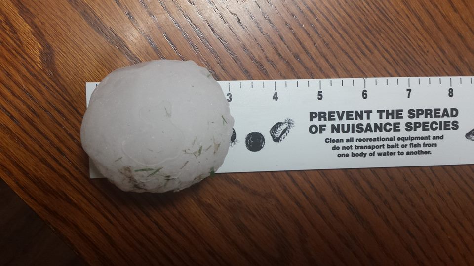
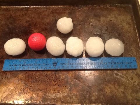
Hail:
Large hail and damaging winds were also produced with these supercells during the late afternoon into the evening hours. Some notable reports were 3+ inch hail in downtown and western Dodge City, one 5 inch hailstone, numerous electric poles snapped, 80+ mph winds in Rush County, golfball hail east of Liberal, and 1 - 1.5 inch hail in downtown Pratt.
 |
 |
 |
 |
| 5 inch hail south of Dodge City | Tennis ball sized hail (courtesy of David Snodgrass) | 3 inch hail in Dodge City (courtesy of Marc Russel | Golfball sized hail in Dodge City (courtesy of Nick Cossman) |
Storm Reports
All WFO DDC storm reports at this web address: https://mesonet.agron.iastate.edu/lsr/#DDC/201605242100/201605250459/0101
PRELIMINARY LOCAL STORM REPORT...SUMMARY
NATIONAL WEATHER SERVICE DODGE CITY KS
659 AM CDT WED MAY 25 2016

..TIME...   ...EVENT...      ...CITY LOCATION...     ...LAT.LON...
..DATE...   ....MAG....      ..COUNTY LOCATION..ST.. ...SOURCE....
            ..REMARKS..

0357 PM     TORNADO          5 NW SHALLOW WATER      38.42N 100.99W
05/24/2016                   SCOTT              KS   STORM CHASER

            REPORT AND PICTURE WAS RECEIVED THROUGH
            TWITTER.

0421 PM     TORNADO          4 W SCOTT CITY          38.48N 100.98W
05/24/2016                   SCOTT              KS   NWS EMPLOYEE

            THERE WAS A CONFIRMED LARGE CONE TORNADO.

0424 PM     TORNADO          2 NW SCOTT CITY         38.50N 100.93W
05/24/2016                   SCOTT              KS   NWS EMPLOYEE

            TORNADO LOCATION BASED ON RADAR. NWS
            EMPLOYEE REPORTED A THIN ROPE TORNADO.

0455 PM     TORNADO          4 NNW MANNING           38.61N 100.75W
05/24/2016                   SCOTT              KS   NWS EMPLOYEE


0509 PM     TORNADO          5 N MANNING             38.63N 100.72W
05/24/2016                   SCOTT              KS   EMERGENCY MNGR


0511 PM     TORNADO          5 N MANNING             38.63N 100.72W
05/24/2016                   SCOTT              KS   EMERGENCY MNGR

            A 7 TO 9 MINUTE ELEPHANT TRUNK SHAPE TORNADO
            OBSERVED.

0529 PM     TORNADO          1 NW SHIELDS            38.63N 100.46W
05/24/2016                   LANE               KS   NWS EMPLOYEE


0531 PM     HAIL             5 S HAYNE               37.03N 100.82W
05/24/2016  E1.75 INCH       SEWARD             KS   PUBLIC

            LOCATION ESTIMATED BY RADAR

0535 PM     HAIL             2 NE HAYNE              37.12N 100.77W
05/24/2016  E1.75 INCH       SEWARD             KS   PUBLIC


0540 PM     HAIL             3 NW MINNEOLA           37.48N 100.05W
05/24/2016  E1.75 INCH       FORD               KS   NWS EMPLOYEE


0548 PM     TORNADO          1 E PENDENNIS           38.64N 100.32W
05/24/2016                   LANE               KS   NWS EMPLOYEE

            BRIEF TORNADO ON THE GROUND FOR AROUND 10
            SECONDS.

0549 PM     FUNNEL CLOUD     5 N MINNEOLA            37.52N 100.01W
05/24/2016                   FORD               KS   STORM CHASER


0552 PM     HAIL             3 NW MINNEOLA           37.47N 100.05W
05/24/2016  E1.75 INCH       FORD               KS   NWS EMPLOYEE


0554 PM     TORNADO          9 NW MINNEOLA           37.54N 100.12W
05/24/2016                   FORD               KS   STORM CHASER

            BRIEF TORNADO TOUCHDOWN REPORTED.

0604 PM     TORNADO          7 ESE ENSIGN            37.61N 100.11W
05/24/2016                   FORD               KS   NWS EMPLOYEE

            CONE TORNADO ON THE GROUND

0609 PM     HAIL             9 ESE KALVESTA          38.00N 100.15W
05/24/2016  E1.75 INCH       HODGEMAN           KS   PUBLIC


0610 PM     TORNADO          8 ESE ENSIGN            37.60N 100.10W
05/24/2016                   FORD               KS   LAW ENFORCEMENT


0611 PM     TORNADO          12 SSE BEELER           38.27N 100.15W
05/24/2016                   NESS               KS   STORM CHASER

            BRIEF TORNADO ON THE GROUND. LOCATION
            ESTIMATED FROM RADAR.

0611 PM     TORNADO          12 S BEELER             38.27N 100.15W
05/24/2016                   NESS               KS   STORM CHASER

            BRIEF TORNADO ON THE GROUND. LOCATION
            ESTIMATED FROM RADAR.

0617 PM     TORNADO          11 SSE BEELER           38.30N 100.10W
05/24/2016                   NESS               KS   STORM CHASER

            TORNADO ON THE GROUND. LOCATION ESTIMATED BY
            RADAR

0620 PM     HAIL             3 NNE HAYNE             37.14N 100.78W
05/24/2016  E1.00 INCH       SEWARD             KS   PUBLIC


0626 PM     HAIL             3 SW DODGE CITY         37.73N 100.05W
05/24/2016  E1.00 INCH       FORD               KS   NWS EMPLOYEE


0630 PM     HAIL             1 WNW DODGE CITY        37.76N 100.03W
05/24/2016  E1.25 INCH       FORD               KS   NWS EMPLOYEE


0630 PM     TORNADO          7 SW DODGE CITY         37.69N 100.11W
05/24/2016                   FORD               KS   LAW ENFORCEMENT

            LAW ENFORCEMENT REPORTED TWO TORNADOES 6 TO
            8 MILES SOUTHWEST OF DODGE CITY.

0632 PM     TORNADO          6 ESE ENSIGN            37.63N 100.13W
05/24/2016                   FORD               KS   TRAINED SPOTTER

            MULTIPLE REPORTS OF 2 TORNADOES ON THE
            GROUND.

0635 PM     TORNADO          6 SW DODGE CITY         37.71N 100.10W
05/24/2016                   FORD               KS   LAW ENFORCEMENT

            HOMES WERE REPORTED TO BE DESTROYED.

0640 PM     HAIL             1 WNW DODGE CITY        37.77N 100.03W
05/24/2016  M3.00 INCH       FORD               KS   NWS EMPLOYEE


0645 PM     TORNADO          7 SW FT. DODGE          37.65N 100.02W
05/24/2016                   FORD               KS   STORM CHASER

            A MULTIPLE VORTEX TORNADO WAS REPORTED WEST
            OF 117232 US 283, APPROXIMATELY 7 MILES
            SOUTH OF DODGE CITY, KS.

0703 PM     HAIL             NESS CITY               38.45N 99.91W
05/24/2016  E1.00 INCH       NESS               KS   CO-OP OBSERVER


0703 PM     TSTM WND GST     NESS CITY               38.45N 99.91W
05/24/2016  E80 MPH          NESS               KS   CO-OP OBSERVER


0709 PM     TORNADO          6 NNE HOWELL            37.86N 100.15W
05/24/2016                   FORD               KS   TRAINED SPOTTER


0710 PM     TORNADO          5 ESE ENSIGN            37.62N 100.14W
05/24/2016                   FORD               KS   EMERGENCY MNGR

            A BUILDING WAS DAMAGED AND THERE WERE POWER
            POLES DOWN. THE TIME WAS ESTIMATED USING
            RADAR. THE INFORMATION WAS RECEIVED THROUGH
            COMMUNICATIONS RADIO.

0710 PM     TORNADO          6 NNW DODGE CITY        37.84N 100.05W
05/24/2016                   FORD               KS   TRAINED SPOTTER

            SPOTTER REPORTED A STRUCTURE DESTROYED ALONG
            110TH ROAD.

0720 PM     TORNADO          7 N DODGE CITY          37.87N 100.02W
05/24/2016                   FORD               KS   TRAINED SPOTTER


0723 PM     TORNADO          7 N DODGE CITY          37.86N 100.02W
05/24/2016                   FORD               KS   STORM CHASER

            STORM CHASER REPORTED SIGNIFICANT DAMAGE TO
            A STRUCTURE. A LARGE PROPANE TANK WAS ON THE
            HIGHWAY SPEWING GAS.

0725 PM     HAIL             3 SW DODGE CITY         37.73N 100.05W
05/24/2016  E2.75 INCH       FORD               KS   NWS EMPLOYEE


0727 PM     HAIL             3 WSW TICE              37.50N 100.78W
05/24/2016  E1.00 INCH       HASKELL            KS   PUBLIC


0727 PM     HAIL             6 N DODGE CITY          37.85N 100.02W
05/24/2016  E2.50 INCH       FORD               KS   STORM CHASER


0736 PM     TORNADO          8 S JETMORE             37.97N 99.89W
05/24/2016                   HODGEMAN           KS   STORM CHASER


0739 PM     FUNNEL CLOUD     9 S JETMORE             37.95N 99.88W
05/24/2016                   HODGEMAN           KS   STORM CHASER


0740 PM     TORNADO          3 WSW CENTERVIEW        37.79N 99.32W
05/24/2016                   EDWARDS            KS   PUBLIC

            TORNADO DAMAGE WAS REPORTED ON HIGHWAY 183
            WEST OF CENTERVIEW.

0740 PM     TORNADO          8 S JETMORE             37.97N 99.89W
05/24/2016                   HODGEMAN           KS   STORM CHASER


0746 PM     TORNADO          6 S JETMORE             38.00N 99.89W
05/24/2016                   HODGEMAN           KS   STORM CHASER


0753 PM     TSTM WND GST     7 N MCCRACKEN           38.69N 99.57W
05/24/2016  E80 MPH          RUSH               KS   LAW ENFORCEMENT


0816 PM     HAIL             SAWYER                  37.50N 98.68W
05/24/2016  E1.50 INCH       PRATT              KS   PUBLIC


0839 PM     TORNADO          3 SW OTIS               38.51N 99.09W
05/24/2016                   RUSH               KS   LAW ENFORCEMENT


0840 PM     FUNNEL CLOUD     4 ENE SAWYER            37.51N 98.62W
05/24/2016                   PRATT              KS   EMERGENCY MNGR


0903 PM     HAIL             PRATT                   37.64N 98.74W
05/24/2016  E1.00 INCH       PRATT              KS   LAW ENFORCEMENT


0910 PM     HAIL             PRATT                   37.64N 98.74W
05/24/2016  E1.25 INCH       PRATT              KS   TRAINED SPOTTER


0916 PM     HAIL             PRATT                   37.65N 98.74W
05/24/2016  E0.75 INCH       PRATT              KS   EMERGENCY MNGR


1158 PM     HAIL             5 SE ASH VALLEY         38.26N 99.15W
05/24/2016  E0.75 INCH       PAWNEE             KS   CO-OP OBSERVER


0720 PM     TORNADO          10 N DODGE CITY         37.91N 100.02W
05/24/2016                   FORD               KS   STORM CHASER
 |
Media use of NWS Web News Stories is encouraged! Please acknowledge the NWS as the source of any news information accessed from this site. |
|