Flash flooding threatens areas from the Tennessee Valley to the Carolinas as storms repeat along a stalled front. Monsoonal storms may trigger flooding in the Southwest. Dangerous heat expands across the Desert Southwest, Plains, mid-Mississippi Valley and Southern Tier. Critical fire weather for interior Pacific Northwest. Cooler, drier air brings brief relief to the Great Lakes and Northeast. Read More >
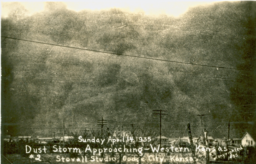
April 14th is the 88 year anniversary of the ”Black Sunday” dust storm that occurred across the Central Plains in 1935. A cold front dropped south across the region that day resulting in a massive dust storm that brought visibilities down to near zero and total darkness in the middle of the day. Dust storms were common during the 30s in the Great Plains, especially during the early and middle part of the decade. This period in history was known as the Dust Bowl era. The dust storms were caused by a drought during the 30s and by the way land was plowed back then. For many years, deep plowing eventually left the land with little top soil. With the natural grasses no longer in place, there was nothing left to anchor the soil. The soil had turned to dust during the drought and whenever the winds would howl, the loose dust would be lifted into the air resulting in dust storms. In April 1935, Dodge City recorded 14 days of dense dust (visibility 1000 feet or less) and 12 days of light dust (visibility above 1000 feet up to 6 miles). March 1935 saw 12 days with dense dust and 14 days of light dust. The April 10th dust storm at Dodge City may have been nearly as bad as the one experienced on April 14th.
The dust storm on April 10th caused the visibility to range from 60 to 300 feet nearly all day. The wind was from the west to northwest at 20 to 30 mph. There was semi-darkness at intervals for most of the day and it was almost as dark as midnight for long stretches in the afternoon. Reports that day were that conditions were the same into eastern Colorado and the rest of western Kansas. Travel in Dodge City was very difficult and all but impossible in the rural areas. One story explained how people knew to get to their destinations before the dust arrived. If caught out in it while traveling, they could only tell where they were by opening the car door and looking for the side of the road.
Dust continued on the next day on the 11th with visibility less than 300 feet for most of the day. It was reported that “wheat, what is left alive, was burnt by the electricity in the air during the storm more than at any previous time.” People began cleaning out the dust on the 12th. The downtown streets were covered in dust an inch thick in places. Where the sidewalks were cleared off, the gutters and streets were a foot deep in great piles of dust. The city had to haul loads of this dust away before the water hoses could be turned on to wash off the streets.
On April 14th at 2:49 PM, a great black dust cloud came in from the north. It was estimated at 500 to 600 feet in height and was moving at a rate of 50 to 60 mph. The instant it struck almost total darkness set in. The following is a quote from the Weather Bureau logs: “The onrushing cloud, the darkness, and the thick, choking dirt, made this storm one of terror and the worst, while it lasted, ever known here.” Some observers had seen hundreds of birds, geese, ducks and other kinds flying in front of the dust cloud. A number of dead small birds were found on the ground after the storm. The Red Cross established a relief setup for dust sufferers. The headquarters was in Liberal Kansas. According to Red Cross officials, 17 deaths had been reported in Kansas from dust pneumonia and three died from dust suffocation. This was from the Weather Bureau log on April 24th. Dust pneumonia resulted when lungs were filled with dust. Symptoms included a high fever, chest pains, coughing and breathing difficulties.
More than a half million people were left homeless as a result of the Dust Bowl era. Farm families lost their land and homes due to the barren land. As many as 2.5 million people had migrated from the Great Plains by 1940. The rains eventually returned and farming practices were improved.
Newspaper Articles courtesy of the Kansas Heritage Center in Dodge City.
Weather Observations from the Weather Bureau in Dodge City from April 10th 1935 through April 17th 1935.
Weather synopsis provided by Jonathan Finch, Meteorologist:
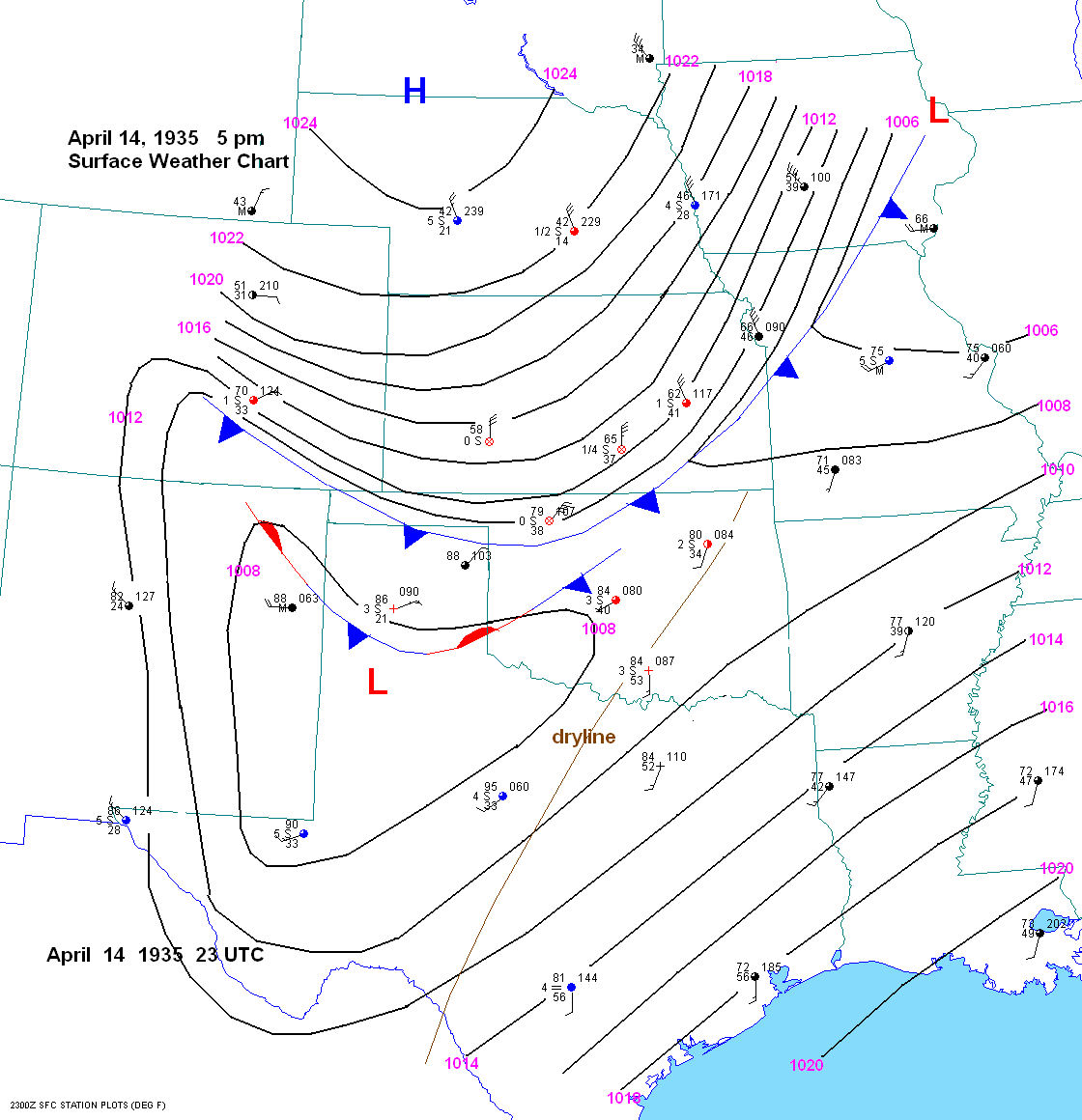
On April 14 th , 1935, a duststorm initiated across central Nebraska in the mid-morning hours and raced south for 800 miles to near the Mexican border by 4 am April 15th. Grand Island, NE experienced a northerly wind shift around 930 am, with visibilities dropping down to around 1/4 mile. Gusty winds and very low visibilities persisted all day. The front passed through the Goodland, KS area around midday and through Dodge City around 3 pm . At 3 pm, the temperature in Dodge City was 84 degrees with a north wind at 15 mph and zero visibility. Shortly thereafter the temperature fell into the 60s and then the 50s along with north to northeast winds at 20 to 30 mph and visibilities near zero. The duststorm lasted for several hours behind the cold front. The dust and high winds arrived in Waynoka, OK, Wichita, KS and Emporia, KS around 4 pm with visibilities near zero and 35 to 50 mph north to northeast winds. The cold front arrived in Canadian, TX shortly after 5 pm with visibilities dropping to zero, temperatures dropping from the 80s into the lower 60s, and northeast winds at 50 mph. The duststorm arrived in Amarillo, TX between 650 and 715 pm with visibilities dropping to zero, along with northeast winds at 50 mph. Oklahoma City experienced a wind shift to the northwest around 7 pm with near zero visibility. By 742 pm the temperature had dropped to 64 degrees with a 42 mph north to northeast winds. The cold front passed through Ardmore, OK (near the Red River) at 10 pm, with visibilities dropping to 1/2 mile. Even eastern New Mexico was not spared from the duststorm. Clayton, NM experienced very low visibilities. In fact, the duststorm arrived in Roswell, NM after midnight with visibilities dropping to 1/8 mile. The duststorm weakened after crossing into north central, TX around midnight as visibilities dropped to around 2 miles with northeast winds around 25 mph at Gainesville. However, farther west the duststorm charged into the Texas Big Bend area around 2 am with near zero visibilities. The duststorm finally wound down near the US-Mexican border around 4 to 5 am on April 15. So when all was done, this duststorm had covered an area about 800 miles long and 300-500 miles wide from central Nebraska to the Mexican border and from Pueblo, CO to eastern, KS.
Surface weather chart for April 14th at 5 PM:
(click on the image for a larger version)
Cold Front position at different times as it moved south:
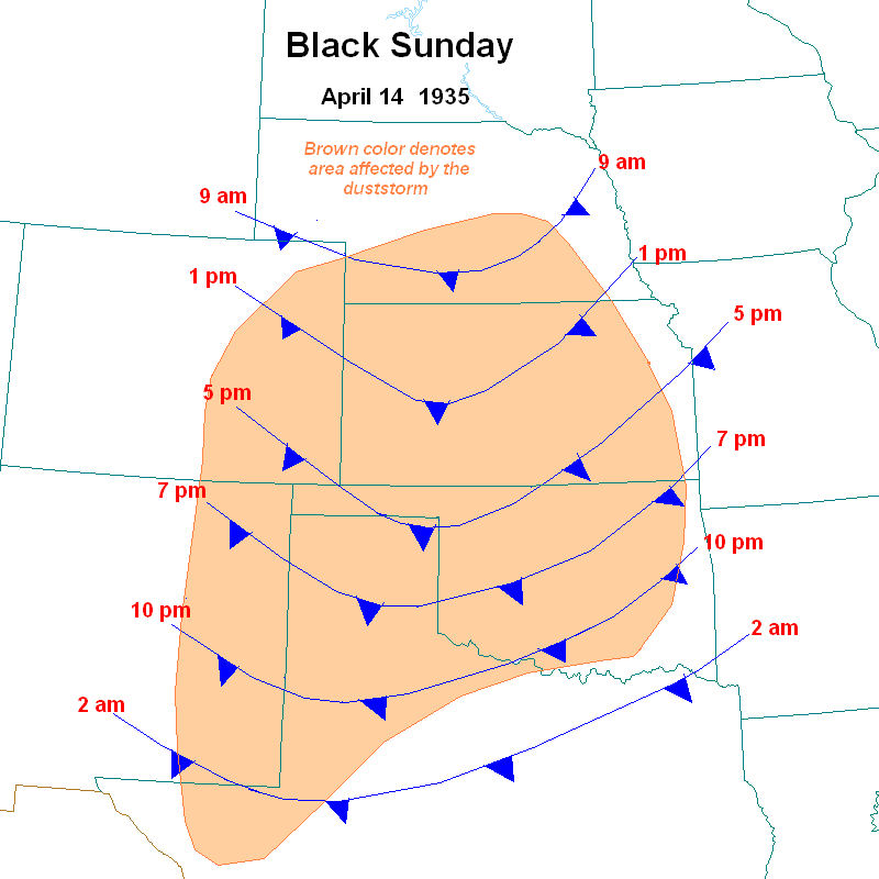
Image courtesy of the Kansas Heritage Center in Dodge City:
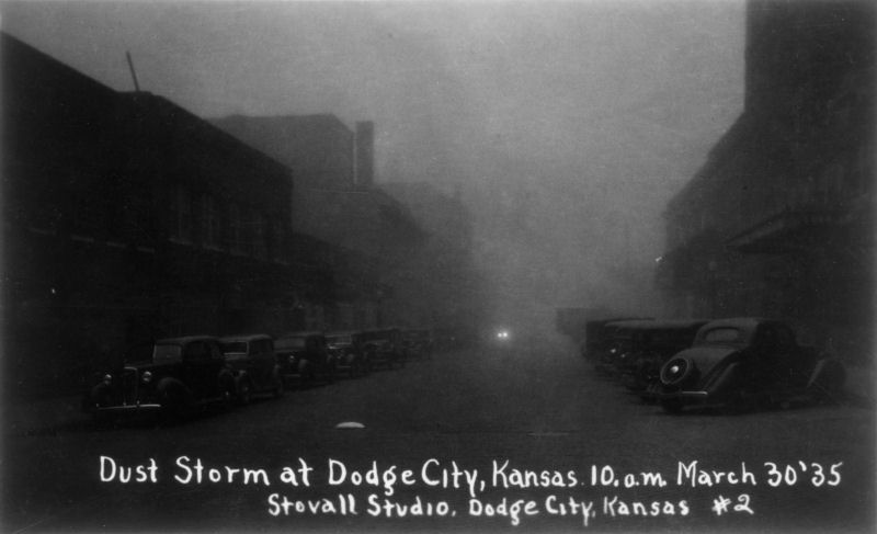
Image courtesy of the Kansas Heritage Center in Dodge City:
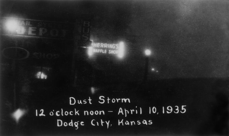
Image courtesy of the Kansas Heritage Center in Dodge City:
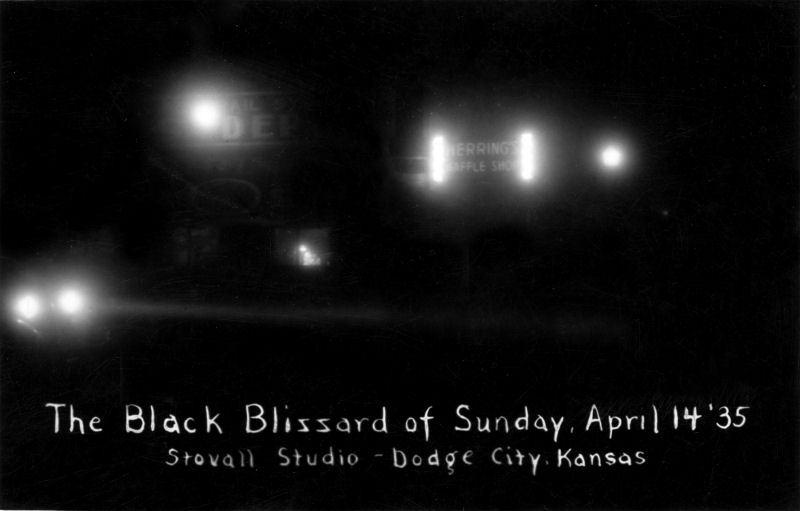
Image courtesy of Don Hahn:

Image courtesy of Don Hahn:
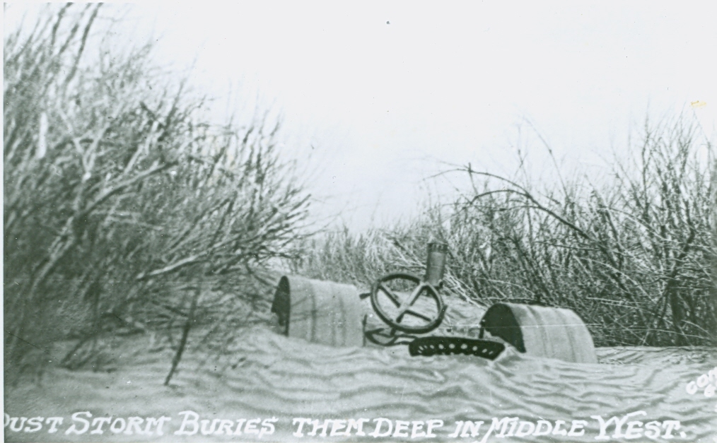
Image courtesy of Don Hahn:
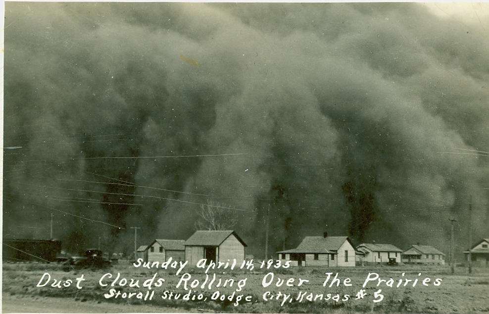
Image courtesy of Don Hahn:
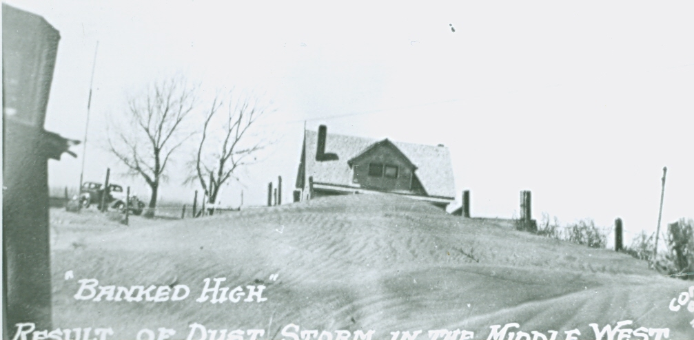
Image courtesy of Don Hahn:
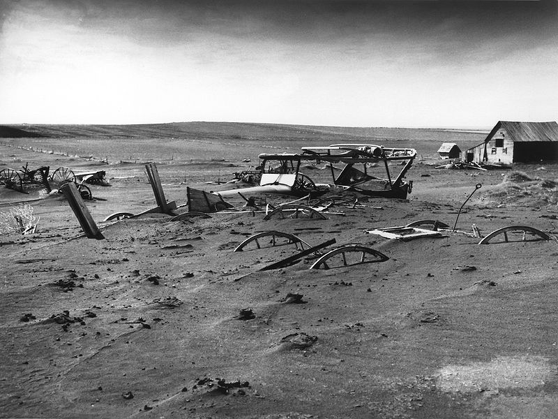
Buried machinery in a barn lot in Dallas, South Dakota:
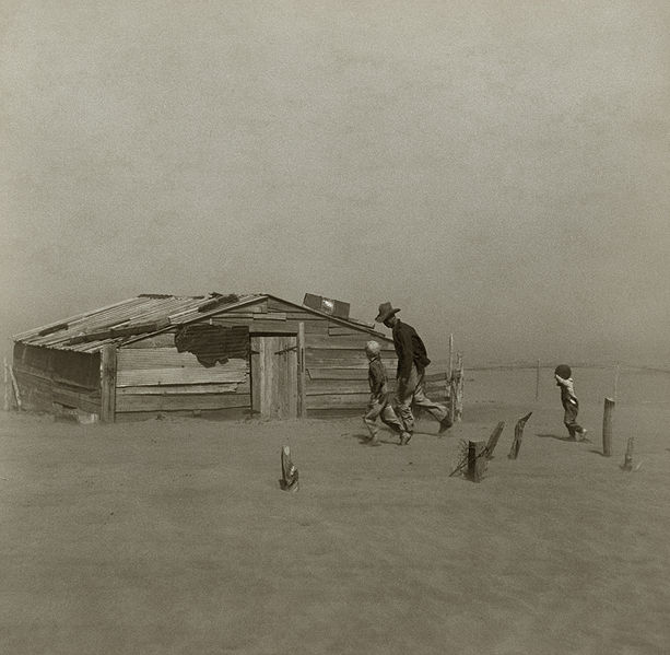
Farmer and sons walking in the face of a dust storm. Cimarron County, Oklahoma: