Widespread life-threatening flash and urban flooding will continue to pose a significant threat to life and property in south-central Texas. Catastrophic fiver flooding, with rapid rises on small streams, arroyos, and typically dry washes, is expected. Monsoonal showers persist across the Great Basin and Southwest with greatest flash flooding in southern Arizona. Read More >
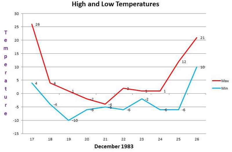
(by Jesse Lee) December 17th marks the 40 year anniversary of a week-long cold wave that affected southwestern Kansas. An outbreak of arctic air hit Dodge City during the early morning hours of the 17th. The temperature at midnight was 26 degrees and had fallen to 8 degrees by early afternoon. From 11 am on the 17th to 2 pm on the 25th the temperature did not rise above 9 degrees. At late morning on the 24th the wind chill at Dodge City reached 56 degrees below zero using the old wind chill chart. Using the new wind chill chart that was implemented in 2001 the wind chill was 33 degrees below zero. The actual temperature was 5 below, but winds were gusting to 32 mph from the north. At that time, the barometric pressure at Dodge City reached 31.18 inches, setting a highest pressure reading for Dodge City. The previous record was 31.14 inches back in 1898 and 1899. High temperatures on the 20th and 21st were only -2 and -4 respectively. The coldest temperature was -10 late in the evening on the 19th. Light snow fell on the 19th, 20th and 21st for a total of 2.6 inches.
Below are the high and low temperatures from December 17th to December 26th. December 18th to December 25th was the coldest 8 day period on record for Dodge City with an average of -1.9 degrees. The second coldest 8 day period on record is January 8th, 1875 to January 15th, 1875 with an average of -1.2 degrees.
Surface Charts (by Jonathan Finch)
The arctic outbreak of December 1983 was particularly brutal. The temperature at Dodge City, KS didn't get above 4F from the 17th at 6pm through the 25th at 9 am. On the 20th and 21st, the temperature never reached zero, and the temperature fell to -10F on the 19th. In addition, several of these days featured 20 to 30 mph winds, which made it feel much colder. Shown below is the surface chart for December 23rd at 3 pm. One of several reinforcing arctic high pressure systems is centered over southern Nebraska at this time. The last arctic surge of this event was passing through South Dakota, on its way toward Kansas. Note that on the 23rd, while it was zero degrees in Dodge City in the afternoon, the temperature was 73F at Carlsbad, NM

Surface map on December 23 at 3pm local

Surface map on December 24, 1983 at 6am local

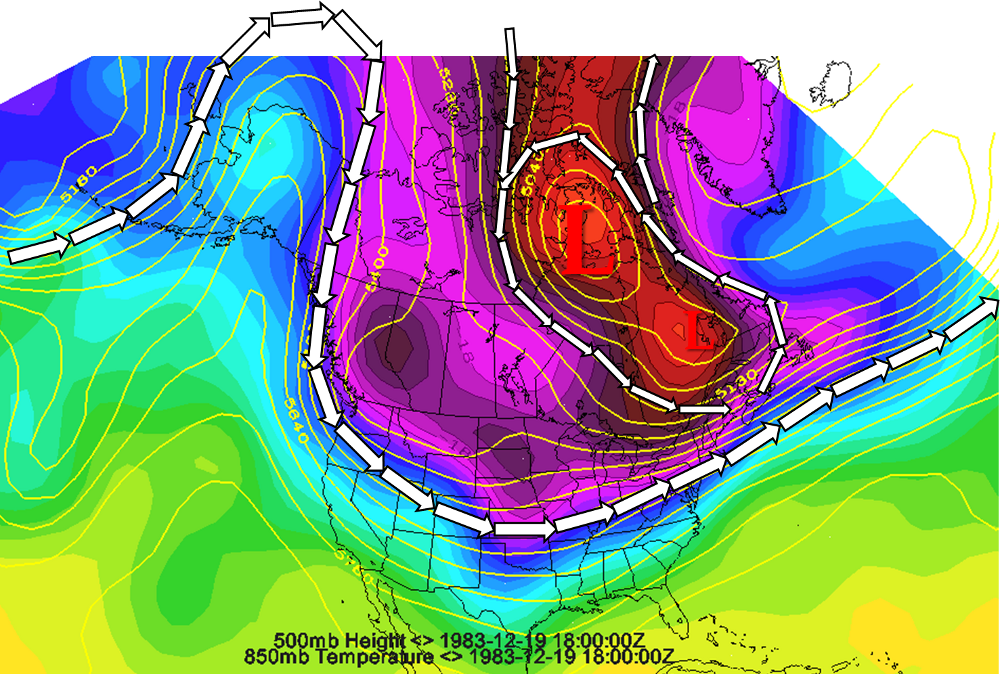
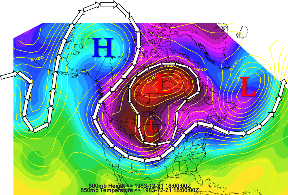
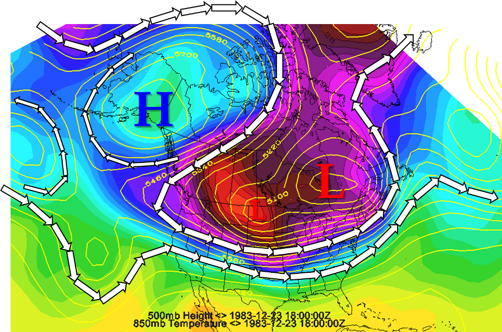
Upper Level Charts (by Mike Umscheid)
The following upper level charts depict the 500mb Height and 850mb Temperature environment on the hemispheric scale. The charts were constructed using the NOAA/ESRL PSD Reanalysis dataset and Unidata IDV gridded display software. The charts are valid December 19th at Noon local time, December 21st at Noon, and December 23rd at Noon. As is typical with nearly all Great Plains arctic air outbreaks, a significant ridge of high pressure was occurring over Alaska. The overall jet stream pattern was extremely amplified, which led to the southwest retrogression of the Polar Vortex. During the arctic air outbreak, the Polar Vortex shifted and expanded southwestward at the same time high pressure expanded across high-latitude of western North America. This upper air pattern was ideal for creating one of the largest surface high pressure areas ever recorded across North America (including the record highest mean sea-level pressure at Dodge City of 31.18in Hg or 1055.3mb).
White arrows depict the upper level jet stream. Upper level high and low pressure centers are also noted. Purple and red areas depict the coldest arctic airmass at 850mb (roughly 5,000 ft. above the surface)