Overview
After widespread morning clouds and fog on Tuesday, September 19th, 2017, there were some questions as to when and where late afternoon and evening severe thunderstorms would form. As a frontal boundary moved into the Devils Lake to Jamestown corridor by late afternoon, storms began to form. These storms moved slowly eastward through the evening, producing isolated tornadoes, large hail, and strong winds. These storms weakened during the early morning hours of Wednesday, September 20th.Tornadoes:
This information will be updated as it is made available.
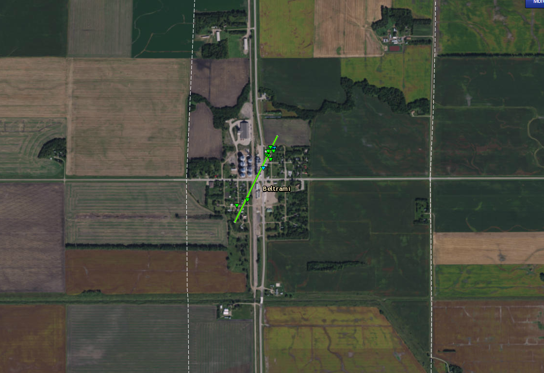
Beltrami, MN Tornado Track


.Beltrami, MN Tornado...

Rating:                 EF-1
Estimated peak wind:    105 mph
Path length /Statute/:  0.40 miles
Path width /Maximum/:   100 yards
Fatalities:             0
Injuries:               0

Start date:             Sep 19 2017
Start time:             757 PM CDT
Start location:         SW edge of Beltrami
Start Lat/Lon:          47.5452/-96.5300

End date:               Sep 19 2017
End time:               800 PM CDT
End location:           NNE edge of Beltrami
End_lat/lon:            47.5401_/-96.5337

Damage from this tornado included several snapped trees on the
southwest side of town as well as damage to a garage and a metal
storage building storing farm equipment on the north-northeast
edge of town. The metal storage building was completed removed
and debris was scattered in a nearby field.

Also, a brief touchdown occurred 2 mi south of Beltrami at 752 PM
CDT. This was also an EF-1 rating with a peak wind speed estimate
of 95 mph.

This is an image of the radar rotation from near Litchville, ND, at 4:41 pm Tuesday.
.Litchville Tornado...

Rating:                 EF-1
Estimated peak wind:    Up to 110 mph
Path Length:            1 Mile
Fatalities:             0
Injuries:               0

Start date:             Sept 19 2017
Start time:
Start location:         1 ENE Litchville ND / Barnes Co.
Start Lat/Lon:

End date:               Sept 19 2017
End time:
End location:           2 ENE Litchville ND / Barnes Co.
End_lat/lon:

This tornado tracked eastward and snapped and uprooted several
spruce trees. Also, roofing material and a door of a shed was
damaged.
The Enhanced Fujita (EF) Scale classifies tornadoes into the following categories:
| EF0 Weak 65-85 mph |
EF1 Moderate 86-110 mph |
EF2 Significant 111-135 mph |
EF3 Severe 136-165 mph |
EF4 Extreme 166-200 mph |
EF5 Catastrophic 200+ mph |
 |
|||||
Radar:
| 3 PM to 9 PM Tue | 9 PM Tue to 3 AM Wed |
Storm Reports
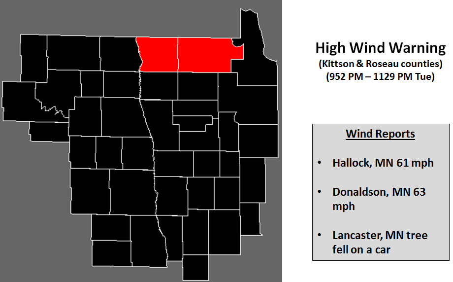
..TIME...   ...EVENT...      ...CITY LOCATION...     ...LAT.LON...
..DATE...   ....MAG....      ..COUNTY LOCATION..ST.. ...SOURCE....
            ..REMARKS..

0430 PM     HAIL             2 SE LITCHVILLE         46.64N 98.16W
09/19/2017  E1.00 INCH       BARNES             ND   NWS EMPLOYEE

            QUARTER SIZED HAIL ACCOMPANIED BY 50 TO 60 MPH WINDS.

0441 PM     TSTM WND DMG     1 NE LITCHVILLE         46.67N 98.18W
09/19/2017                   BARNES             ND   PUBLIC

            BARN HAD DAMAGE TO ROOF WITH TREE LIMBS IN ROOF. HOUSE
            HAD SHINGLES REMOVED.

0545 PM     TSTM WND GST     2 NE BUFFALO            46.94N 97.52W
09/19/2017  E60.00 MPH       CASS               ND   PUBLIC

            STRONG WINDS WITH PEA SIZE HAIL.

0655 PM     HAIL             2 N ESMOND              48.06N 99.76W
09/19/2017  E1.00 INCH       BENSON             ND   PUBLIC

0859 PM     TSTM WND GST     FOSSTON                 47.58N 95.75W
09/19/2017  M63.00 MPH       POLK               MN   AWOS

            KFSE OBSERVATION INDICATED WIND GUSTS TO 63 MPH FROM THE
            SOUTHWEST.

0930 PM     NON-TSTM WND GST HALLOCK                 48.77N 96.94W
09/19/2017  M61.00 MPH       KITTSON            MN   AWOS

            KHCO HALLOCK AWOS GUST. TIME ESTIMATED. SOUTHEAST WINDS
            TO THE NORTH OF THE THUNDERSTORMS TO THE SOUTH.

0930 PM     TSTM WND GST     DONALDSON               48.57N 96.90W
09/19/2017  M63.00 MPH       KITTSON            MN   MESONET

            MEASURED BY A MNDOT RWIS SENSOR.

0935 PM     TSTM WND DMG     LANCASTER               48.86N 96.80W
09/19/2017                   KITTSON            MN   PUBLIC

            TREE FELL ON CAR. OCCURRED DURING HIGH WINDS TO 60 MPH ON
            THE NORTH SIDE OF A COMPLEX OF STORMS.
Rain Reports

...Rainfall Reports...

Location                     Amount    Time/Date
Hendrum MN 2 W               8.10 in   0700 AM 09/20   47.27N/96.86W
Grandin ND                   7.57 in   0700 AM 09/20
Absaraka ND                  7.50 in   0700 AM 09/20
Gardner ND 3 SW              6.10 in   0700 AM 09/20
Halstad MN                   5.54 in   0800 AM 09/20   47.35N/96.83W
Ada MN                       5.50 in   0700 AM 09/20
Amenia ND                    5.25 in   0700 AM 09/20
Marion ND 5 S                4.50 in   0700 AM 09/20
Fertile MN                   4.40 in   0600 AM 09/20   47.53N/96.28W
Valley City ND 2 SSE         4.21 in   0700 AM 09/20   46.88N/97.99W
Ada MN                       3.95 in   0705 AM 09/20   47.30N/96.52W
Fingal ND (NDAWN)            3.95 in   0705 AM 09/20   46.76N/97.80W
2 SW Mentor                  3.59 in   1128 AM 09/20   47.67N/96.17W
Perley MN (NDAWN)            3.57 in   0705 AM 09/20   47.17N/96.80W
Cormorant MN 2 NNW           3.50 in   0800 AM 09/20   46.77N/96.07W
Fertile MN 3 WSW  (Sandhill  3.46 in   1045 AM 09/20   47.51N/96.34W
2 SW Mentor                  3.40 in   0700 AM 09/20   47.67N/96.17W
Dugdale MN 3 ENE             3.38 in   1032 AM 09/20   47.72N/96.21W
Maple Bay MN 5 ESE           3.26 in   0700 AM 09/20   47.59N/96.13W
Valley City ND 2 NW          3.13 in   0700 AM 09/20   46.94N/98.04W
Westbury MN 3 ESE            2.68 in   0700 AM 09/20   46.89N/95.84W
Detroit Lakes MN (APT)       2.61 in   0653 AM 09/20   46.83N/95.89W
Dunvilla MN 4 W              2.60 in   0700 AM 09/20   46.66N/96.11W
Wahpeton ND                  2.52 in   0700 AM 09/20   46.28N/96.61W
Cormorant MN 5 NW            2.51 in   0700 AM 09/20   46.80N/96.12W
Red Lake Falls MN            2.48 in   0700 AM 09/20   47.88N/96.28W
Casselton ND                 2.40 in   0800 AM 09/20   46.88N/97.23W
Detroit Lakes MN (DNR)       2.39 in   1120 AM 09/20   46.85N/95.85W
Mavie MN 5 SSE               2.33 in   0700 AM 09/20   48.07N/95.92W
Brooks MN 3 WNW (Lost R)     2.32 in   1045 AM 09/20   47.83N/96.05W
Red Lake Falls MN            2.28 in   1030 AM 09/20   47.90N/96.27W
Breckenridge MN (Ottertail R 2.12 in   1100 AM 09/20   46.27N/96.58W
Roseau MN                    2.05 in   0800 AM 09/20   48.84N/95.76W
Roseau MN                    2.04 in   1115 AM 09/20   48.85N/95.76W
Rothsay MN                   2.03 in   0730 AM 09/20   46.48N/96.27W
Baudette MN 12 S             2.01 in   1115 AM 09/20   48.54N/94.56W
Breckenridge                 1.95 in   0700 AM 09/20   46.26N/96.60W
Roseau MN (DNR)              1.94 in   1108 AM 09/20   48.85N/95.70W
Mavie MN 2 S (NDAWN)         1.85 in   0705 AM 09/20   48.12N/95.95W
Abercrombie ND               1.85 in   0600 AM 09/20   46.45N/96.73W
Blabon ND 4 SW               1.85 in   0700 AM 09/20   47.34N/97.83W
Ponsford MN 10 N             1.75 in   1103 AM 09/20   47.11N/95.41W
Crookston MN                 1.73 in   0630 AM 09/20   47.78N/96.59W
Wilton MN 6 NE               1.72 in   1124 AM 09/20   47.58N/94.92W
Dazey ND (NDAWN)             1.68 in   0705 AM 09/20   47.18N/98.20W
Casselton ND 5 SW            1.67 in   0700 AM 09/20   46.83N/97.26W
2 S Huot                     1.65 in   0700 AM 09/20   47.83N/96.43W
Bemidji MN 13 NNW            1.57 in   1132 AM 09/20   47.66N/94.98W
Greenbush MN (NDAWN)         1.56 in   0705 AM 09/20   48.70N/96.33W
Gatzke MN 9 SW (DNR)         1.55 in   1120 AM 09/20   48.30N/95.87W
Thief River Falls MN         1.49 in   0700 AM 09/20   48.12N/96.18W
Itasca MN (DNR)              1.48 in   1107 AM 09/20   47.24N/95.19W
Lake Itasca 4 NNW            1.48 in   1100 AM 09/20   47.31N/95.25W
Bagley MN 23 S               1.47 in   0700 AM 09/20   47.20N/95.42W
Karlstad MN (DNR)            1.41 in   1106 AM 09/20   48.59N/96.49W
Wilton MN 3 SE               1.41 in   0731 AM 09/20   47.47N/94.95W
Bemidji MN (DNR)             1.40 in   1106 AM 09/20   47.50N/94.93W
Baudette MN (DNR)            1.38 in   1106 AM 09/20   48.67N/94.62W
Grygla MN 6 WNW              1.35 in   1130 AM 09/20   48.33N/95.74W
Greenbush MN                 1.34 in   0700 AM 09/20   48.70N/96.18W
Karlstad                     1.34 in   0803 AM 09/20   48.58N/96.52W
Norris Camp (MN DNR)         1.29 in   0800 AM 09/20   48.61N/95.18W
Felton MN 6 ENE              1.28 in   1045 AM 09/20   47.11N/96.39W
Kelliher MN (DNR)            1.25 in   1107 AM 09/20   47.94N/94.45W
Mahnomen MN 1 SE             1.25 in   1045 AM 09/20   47.31N/95.95W
Florian MN                   1.25 in   1045 AM 09/20   48.43N/96.63W
Bemidji MN (APT)             1.21 in   0654 AM 09/20   47.51N/94.93W
Breckenridge MN 3 SE         1.21 in   0700 AM 09/20   46.30N/96.52W
Red Lake MN (DNR)            1.21 in   1110 AM 09/20   47.87N/95.03W
Baudette MN (APT)            1.18 in   0653 AM 09/20   48.72N/94.61W
Thief R Falls MN (APT)       1.18 in   0601 AM 09/20   48.06N/96.18W
Warren MN 3 SW (NDAWN)       1.16 in   0705 AM 09/20   48.14N/96.84W
Newfolden MN                 1.14 in   0800 AM 09/20   48.36N/96.33W
Park Rapids MN (APT)         1.14 in   0653 AM 09/20   46.90N/95.07W
Warren MN 3 ENE              1.13 in   1045 AM 09/20   48.21N/96.72W
Mahnomen MN (APT)            1.11 in   0655 AM 09/20   47.26N/95.93W
Galesburg ND (NDAWN)         1.07 in   0705 AM 09/20   47.27N/97.41W
Pennington MN 2 S            1.06 in   1100 AM 09/20   47.45N/94.48W
Lidgerwood ND                1.05 in   0700 AM 09/20   46.07N/97.17W
Crookston MN (NW Experiment  1.02 in   0800 AM 09/20   47.80N/96.62W
Pelican Rapids MN 1 W        1.00 in   0700 AM 09/20   46.57N/96.12W
Bemidji MN 2 SW              0.98 in   1100 AM 09/20   47.45N/94.91W
Holt MN 6 E                  0.97 in   1130 AM 09/20   48.30N/96.07W
Waskish MN 4 NE              0.94 in   1030 AM 09/20   48.18N/94.51W
Mayville ND (NDAWN)          0.92 in   0705 AM 09/20   47.50N/97.22W
Eldred MN (NDAWN)            0.90 in   0705 AM 09/20   47.73N/96.78W
Malung MN                    0.87 in   1030 AM 09/20   48.79N/95.74W
Frazee MN 2 E                0.86 in   0908 AM 09/20   46.73N/95.64W
Baker ND (NDAWN)             0.85 in   0705 AM 09/20   48.16N/99.65W
Menahga MN 1 W               0.85 in   0700 AM 09/20   46.75N/95.14W
March MN 4 NNE               0.84 in   0700 AM 09/20   48.26N/96.87W
Badoura MN (DNR)             0.82 in   1106 AM 09/20   46.86N/94.74W
Sebeka MN                    0.81 in   0700 AM 09/20   46.63N/95.08W
Huntersville 3 WNW           0.78 in   1045 AM 09/20   46.79N/94.95W
Backoo ND 3 WNW              0.75 in   0711 AM 09/20   48.85N/97.78W
2 NW Moorhead                0.74 in   0800 AM 09/20   46.89N/96.78W
Mcleod ND 3 E                0.73 in   0810 AM 09/20   46.40N/97.24W
Mayville ND                  0.73 in   0700 AM 09/20   47.50N/97.35W
New Rockford ND 4 WNW        0.70 in   0700 AM 09/20   47.74N/99.15W
Caribou MN                   0.69 in   1030 AM 09/20   48.98N/96.47W
Grand Forks ND 5 WSW         0.68 in   1126 AM 09/20   47.89N/97.16W
North River ND               0.68 in   0800 AM 09/20   46.94N/96.79W
Big Mcdonald Lake MN 2 NW    0.66 in   0700 AM 09/20   46.60N/95.80W
3 SSE Grand Forks            0.65 in   0700 AM 09/20   47.87N/97.05W
Golden Lake ND               0.65 in   0600 AM 09/20   47.58N/97.63W
Grand Forks ND (NWS)         0.64 in   0711 AM 09/20   47.93N/97.08W
Fargo ND 1 ESE               0.64 in   0930 AM 09/20   46.87N/96.79W
3 SE Grand Forks             0.62 in   0700 AM 09/20   47.87N/97.03W
Alvarado MN                  0.61 in   1030 AM 09/20   48.19N/97.01W
Fort Totten ND               0.61 in   1051 AM 09/20   47.99N/98.97W
Fargo ND 2 NE                0.61 in   0800 AM 09/20   46.91N/96.78W
Hampden ND                   0.60 in   1058 AM 09/20   48.53N/98.62W
Oxbow ND 1 SE                0.60 in   0800 AM 09/20   46.83N/96.78W
Lisbon ND                    0.60 in   0800 AM 09/20   46.44N/97.67W
Warroad MN                   0.60 in   1030 AM 09/20   48.91N/95.30W
Grand Forks ND 4 SSW         0.59 in   0700 AM 09/20   47.85N/97.09W
2 SSE Grand Forks            0.59 in   0700 AM 09/20   47.88N/97.06W
Grand Forks ND (APT)         0.58 in   0653 AM 09/20   47.95N/97.18W
Lisbon ND                    0.58 in   0700 AM 09/20   46.43N/97.68W
Hoffman MN 2 NNW             0.58 in   0700 AM 09/20   45.86N/95.80W
New Rockford ND 0.7 ESE      0.58 in   0800 AM 09/20   47.68N/99.12W
Glyndon MN 2 N               0.57 in   1045 AM 09/20   46.90N/96.58W
North River ND 2 ESE         0.57 in   0800 AM 09/20   46.91N/96.78W
Hoffman MN 3 S               0.54 in   0700 AM 09/20   45.78N/95.78W
West Fargo ND 3.8 SSE        0.54 in   0700 AM 09/20   46.83N/96.85W
Roosevelt MN 5 SSW           0.53 in   1115 AM 09/20   48.73N/95.13W
Leonard ND (NDAWN)           0.52 in   0705 AM 09/20   46.65N/97.25W
Perham MN                    0.49 in   0800 AM 09/20   46.59N/95.56W
4 NE Perham                  0.47 in   0700 AM 09/20   46.65N/95.50W
Fargo ND (NDSU NDAWN)        0.46 in   0705 AM 09/20   46.90N/96.81W
Barrie ND 2 WSW (Ekre NDAWN) 0.46 in   0705 AM 09/20   46.54N/97.14W
Cando ND (NDAWN)             0.45 in   0705 AM 09/20   48.49N/99.21W
Fargo ND (APT)               0.45 in   0553 AM 09/20   46.92N/96.81W
Sabin MN                     0.44 in   0825 AM 09/20   46.78N/96.66W
Lisbon ND 2 W (NDAWN)        0.43 in   0705 AM 09/20   46.44N/97.72W
Wadena MN 13 E               0.42 in   1100 AM 09/20   46.46N/94.84W
Lancaster MN                 0.42 in   0700 AM 09/20   48.86N/96.80W
Oxbow ND  1 SSE              0.42 in   0700 AM 09/20   46.83N/96.80W
Kempton ND 2 NE              0.41 in   0700 AM 09/20   47.84N/97.58W
Poland ND 1 E                0.41 in   0430 AM 09/20   48.20N/97.19W
Glyndon MN 2 Ww (SB Buffalo  0.41 in   1045 AM 09/20   46.90N/96.61W
Stephen MN 4 WNW             0.41 in   1045 AM 09/20   48.49N/96.96W
Edwards MN 5 S               0.40 in   0700 AM 09/20   46.37N/95.99W
Prairie Rose ND              0.39 in   0700 AM 09/20   46.81N/96.82W
7 WNW Golden Lake            0.39 in   0700 AM 09/20   47.65N/97.75W
Havana ND                    0.37 in   0700 AM 09/20   45.95N/97.62W
Dilworth MN 0.8 WNW          0.37 in   0700 AM 09/20   46.88N/96.71W
Clitherall MN 1 WSW          0.36 in   0700 AM 09/20   46.27N/95.65W
Osnabrock ND 3 SW            0.35 in   0700 AM 09/20   48.62N/98.19W
Esmond ND 9 NNW              0.33 in   0800 AM 09/20   48.16N/99.83W
Devils Lake ND (APT)         0.32 in   0656 AM 09/20   48.11N/98.91W
4 NNE Elbow Lake             0.32 in   0800 AM 09/20   46.05N/95.96W
Mcleod ND 3 N                0.32 in   1049 AM 09/20   46.47N/97.32W
Wadena MN (APT)              0.31 in   0652 AM 09/20   46.45N/95.21W
Cavalier ND 7 NW             0.27 in   0705 AM 09/20   48.86N/97.70W
Hallock MN (APT)             0.27 in   0654 AM 09/20   48.77N/96.94W
Forest River ND (NDAWN)      0.26 in   0705 AM 09/20   48.22N/97.47W
Hallock MN                   0.26 in   1100 AM 09/20   48.78N/96.94W
Waskish MN (APT)             0.26 in   0654 AM 09/20   48.15N/94.53W
Elbow Lake MN (APT)          0.26 in   0659 AM 09/20   45.98N/95.98W
Ottertail MN 1 WNW           0.25 in   0645 AM 09/20   46.44N/95.59W
Elizabeth MN 6 E             0.23 in   1130 AM 09/20   46.37N/96.02W
Ottertail MN                 0.23 in   0510 AM 09/20   46.42N/95.57W
Tolna ND Coulee              0.23 in   1100 AM 09/20   47.86N/98.49W
Battle Lake MN 2 S           0.22 in   0700 AM 09/20   46.26N/95.71W
Ottertail Lake MN 1 N        0.21 in   0800 AM 09/20   46.43N/95.67W
Inkster ND 3 WNW (NDAWN)     0.20 in   0705 AM 09/20   48.17N/97.71W
Kennedy MN 6 WNW             0.19 in   1045 AM 09/20   48.67N/97.04W
Crary ND (NDAWN)             0.18 in   0705 AM 09/20   48.06N/98.63W
Campbell MN 4 W (Rabbitt R)  0.17 in   1100 AM 09/20   46.11N/96.49W
Langdon ND                   0.17 in   0705 AM 09/20   48.75N/98.33W
Dalton MN 4 WNW              0.17 in   0700 AM 09/20   46.21N/95.99W
Northcote MN 1 SW            0.16 in   1045 AM 09/20   48.83N/97.02W
Mchenry ND (NDAWN)           0.15 in   0705 AM 09/20   47.60N/98.59W
Michigan ND 2 W (NDAWN)      0.15 in   0705 AM 09/20   48.02N/98.17W
Pembina ND                   0.15 in   0545 AM 09/20   48.97N/97.24W
Kennedy MN 6 W (NDAWN)       0.14 in   0705 AM 09/20   48.64N/97.04W
Michigan ND                  0.12 in   0700 AM 09/20   48.03N/98.13W
St. Thomas ND (NDAWN)        0.10 in   0705 AM 09/20   48.62N/97.45W
Ada MN                       0.06 in   1030 AM 09/20   47.26N/96.50W
Humboldt MN (NDAWN)          0.06 in   0705 AM 09/20   48.92N/97.10W
Warroad MN (APT)             0.05 in   0654 AM 09/20   48.94N/95.35W
Fergus Falls MN 3 W (Pelican 0.03 in   1045 AM 09/20   46.29N/96.14W
Roseau MN (APT)              0.03 in   0654 AM 09/20   48.86N/95.70W
Clementson MN (Rapid R)      0.01 in   1100 AM 09/20   48.69N/94.43W
Flag Island MN               0.01 in   0653 AM 09/20   49.32N/94.88W
Environment
 |
 |
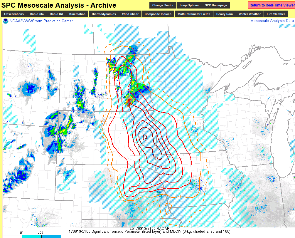 |
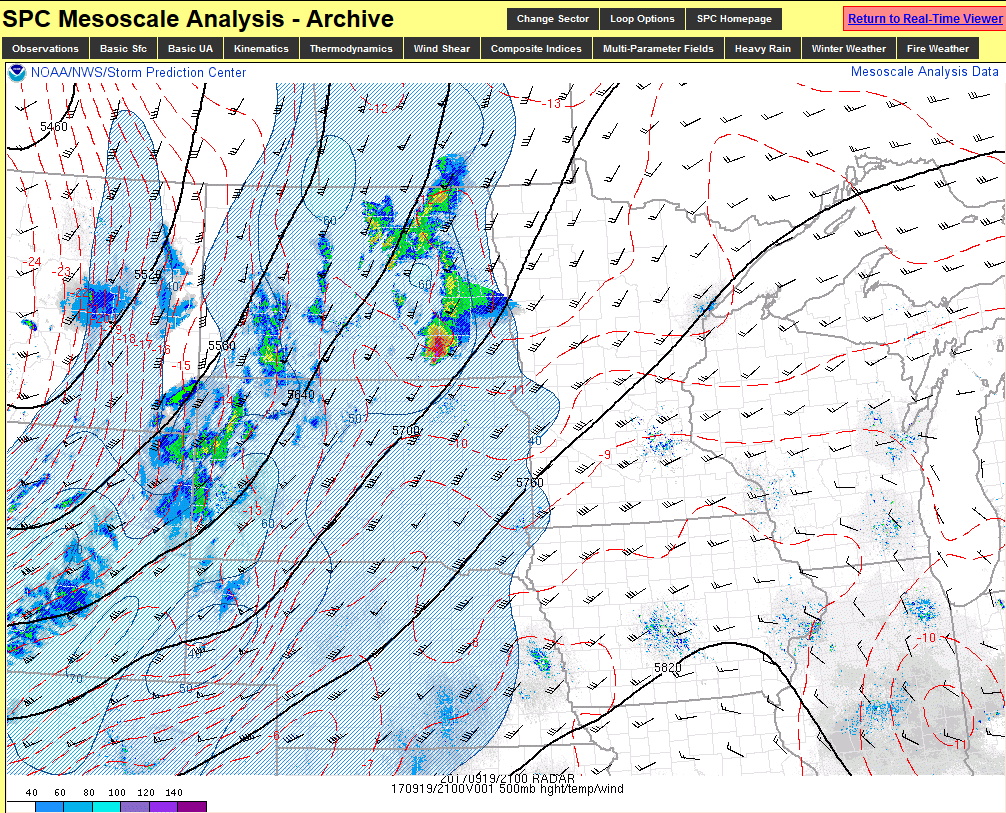
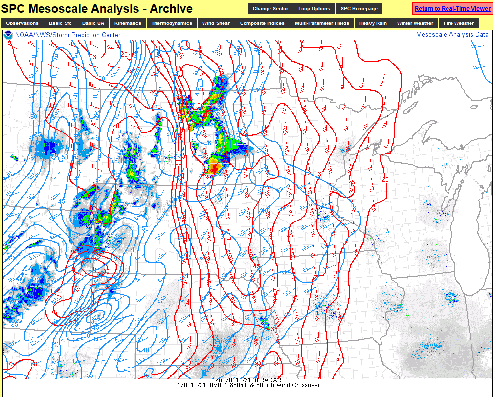
| Figure 1: 500 mb at 4 pm Tue | Figure 2: 850mb winds at 4 pm Tue | Figure 3: SigTor Parameter at 4 pm Tue |
Additional Information
 |
 |
|
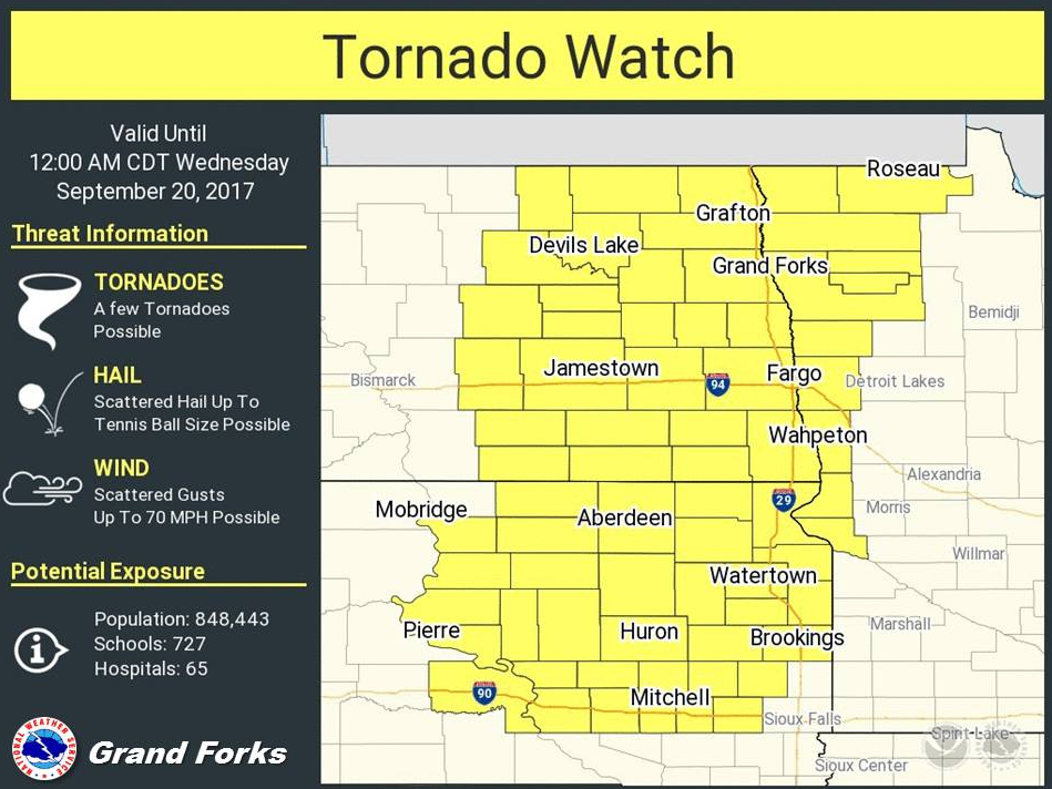
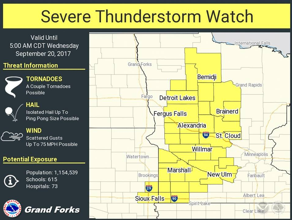
| SPC Tornado Watch | SPC Severe Thunderstorm Watch | NWS Severe Warnings |
 |
||
| NWS High Wind Warning | WPC Fronts | Infrared Satellite Imagery |
 |
Media use of NWS Web News Stories is encouraged! Please acknowledge the NWS as the source of any news information accessed from this site. |
|

