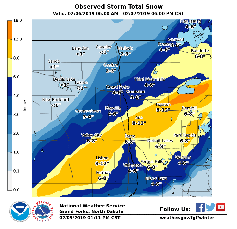
Overview
A strong storm system developed over most of eastern North Dakota and the northwest quarter of Minnesota on Wednesday, February 6th. Decent amounts of snow fell across most of the area, but a band of heavy snow fell along a narrow line from Litchville to just north of Fargo in North Dakota, then through Ada, Fosston, and toward the Lower Red Lake in Minnesota. In this band 8 to 12 inches of snow fell. Bigger impacts developed during the early morning hours of Thursday, February 7th, as strong north-northwest winds increased. These gusty winds lasted through the day and into the early evening, before finally diminishing. This led to blizzard conditions, mainly in the Red River Valley. The blowing and drifting snow became bad enough that portions of Interstates 29 and 94 were temporarily closed during the height of the blizzard. The blowing and drifting also produced some of the largest and densest snow drifts seen in quite a while.
Highest Winds:
...WIND REPORTS FROM ACROSS THE REGION...

LOCATION                     SPEED     TIME/DATE
FARGO ND (AIRPORT)           46 MPH    0948 AM 02/07
WAHPETON ND (DOT)            44 MPH    1124 AM 02/07
GRAND FORKS ND (AIRPORT)     43 MPH    1209 PM 02/07
TENNEY MN (DOT)              42 MPH    0420 PM 02/07
BUXTON ND 4 S (DOT)          42 MPH    0454 PM 02/07
GRAFTON ND (AIRPORT)         41 MPH    0235 PM 02/07
GRAND FORKS ND (DOT)         41 MPH    0409 PM 02/07
FERGUS FALLS MN (AIRPORT)    40 MPH    0355 PM 02/07
HENDRUM MN (DOT)             40 MPH    0616 AM 02/07
BUFFALO ND 7 N (DOT)         40 MPH    0454 PM 02/07
COOPERSTOWN ND (AIRPORT)     40 MPH    0315 PM 02/07
MOORHEAD MN                  39 MPH    0555 AM 02/07
DONALDSON MN (DOT)           39 MPH    0340 PM 02/07
WAHPETON ND (AIRPORT)        38 MPH    0450 PM 02/07
CAVALIER ND (AIRPORT)        37 MPH    0315 PM 02/07
ROTHSAY MN (DOT)             37 MPH    0345 PM 02/07
E GRAND FORKS MN (DOT)       37 MPH    0501 PM 02/07
DEVILS LAKE ND (DOT)         37 MPH    1209 PM 02/07
GRAND FORKS AFB ND (ASOS)    37 MPH    0246 PM 02/07
ELBOW LAKE MN (AIRPORT)      37 MPH    0456 PM 02/07
WALHALLA ND (AIRPORT)        36 MPH    1215 PM 02/07
CROOKSTON MN (AIRPORT)       36 MPH    0456 PM 02/07
GWINNER ND (AIRPORT)         36 MPH    0415 PM 02/07
LANGDON ND (AIRPORT)         35 MPH    1235 PM 02/07
ST VINCENT MN (DOT)          35 MPH    0320 PM 02/07
MCLEOD ND 3 N (USFW)         35 MPH    0149 PM 02/07
LAKE PARK MN (DOT)           34 MPH    0310 PM 02/07
EMERADO ND (DOT)             34 MPH    0509 PM 02/07
HALLOCK MN (AIRPORT)         33 MPH    1235 PM 02/07
DETROIT LAKES MN (MN DNR)    32 MPH    0220 PM 02/07
DETROIT LAKES MN (AIRPORT)   32 MPH    0136 PM 02/07
DEVILS LAKE ND (AIRPORT)     32 MPH    1243 PM 02/07
FRAZEE MN 3 E (CWOP)         32 MPH    0404 PM 02/07
MOORHEAD MN (DOT)            32 MPH    1205 PM 02/07
CANDO ND (AIRPORT)           31 MPH    0115 PM 02/07
LEEDS ND (DOT)               31 MPH    0139 PM 02/07
MAHNOMEN MN (DOT)            30 MPH    0145 PM 02/07
PARK RAPIDS MN (AIRPORT)     30 MPH    0442 PM 02/07


OBSERVATIONS ARE COLLECTED FROM A VARIETY OF SOURCES WITH VARYING
EQUIPMENT AND EXPOSURES. WE THANK ALL VOLUNTEER WEATHER OBSERVERS
FOR THEIR DEDICATION. NOT ALL DATA LISTED ARE CONSIDERED OFFICIAL.
Coldest Wind Chills:
Thursday night (Feb. 7th) into Friday morning (Feb. 8th)

...COLDEST WIND CHILLS OVER THE PAST 12 HOURS AS OF 745 AM CST FEBRUARY 8, 2019...

Location                     Temp      Time/Date       Provider
Devils Lake ND (DOT)         -61 F     0609 AM 02/08   NDDOT
Leeds ND (DOT)               -60 F     0609 AM 02/08   NDDOT
Cando ND (Airport)           -59 F     0735 AM 02/08   ASOS
Langdon ND (Airport)         -57 F     0655 AM 02/08   ASOS
Devils Lake ND (Airport)     -52 F     0656 AM 02/08   ASOS
Cooperstown ND (Airport)     -52 F     0715 AM 02/08   ASOS
Munich ND (AWS)              -51 F     0650 AM 02/08   AWS
Gwinner ND (Airport)         -47 F     0615 AM 02/08   ASOS
Mahnomen MN (Airport)        -46 F     0735 AM 02/08   ASOS
Waskish MN (Airport)         -46 F     0735 AM 02/08   ASOS
Crookston MN (Airport)       -45 F     0736 AM 02/08   ASOS
Mahnomen MN (DOT)            -45 F     0721 AM 02/08   MNDOT
Tenney MN (DOT)              -45 F     0700 AM 02/08   MNDOT
Gatzke MN (DOT)              -45 F     0640 AM 02/08   MNDOT
Park Rapids MN (Airport)     -45 F     0653 AM 02/08   ASOS
Bemidji MN (Airport)         -44 F     0736 AM 02/08   ASOS
Fergus Falls MN (AWS)        -44 F     0719 AM 02/08   AWS
Flag Island MN (AWOS)        -44 F     0735 AM 02/08   ASOS
Rothsay MN (DOT)             -44 F     0710 AM 02/08   MNDOT
Donaldson MN (DOT)           -44 F     0520 AM 02/08   MNDOT
Hendrum MN (DOT)             -44 F     0620 AM 02/08   MNDOT
Lake Park MN (DOT)           -44 F     0645 AM 02/08   MNDOT
Thief River Falls MN (Airpor -44 F     0456 AM 02/08   ASOS
Elbow Lake MN (Airport)      -44 F     0715 AM 02/08   ASOS
Cavalier ND (Airport)        -43 F     0435 AM 02/08   ASOS
Ponsford MN 10 N (CWOP)      -43 F     0703 AM 02/08   CWOP
Wahpeton ND (Airport)        -43 F     0650 AM 02/08   ASOS
Fergus Falls MN (Airport)    -43 F     0735 AM 02/08   ASOS
Fort Totten ND (USFW)        -43 F     0451 AM 02/08   RAWS
Fosston MN (Airport)         -43 F     0656 AM 02/08   ASOS
Grand Forks ND (Airport)     -43 F     0453 AM 02/08   ASOS
Moorhead MN                  -43 F     0735 AM 02/08   ASOS
Badger MN (DOT)              -43 F     0705 AM 02/08   MNDOT
Verndale MN (DOT)            -43 F     0630 AM 02/08   MNDOT
Brooks MN (DOT)              -43 F     0720 AM 02/08   MNDOT
Roseau MN (MN DNR)           -43 F     0708 AM 02/08   RAWS
Roseau MN (Airport)          -43 F     0634 AM 02/08   ASOS
Staples MN (Airport)         -43 F     0736 AM 02/08   ASOS
Detroit Lakes MN (MN DNR)    -42 F     0720 AM 02/08   RAWS
Detroit Lakes MN (Airport)   -42 F     0636 AM 02/08   ASOS
Fargo ND (Airport)           -42 F     0653 AM 02/08   ASOS
Grafton ND (Airport)         -42 F     0635 AM 02/08   ASOS
Ottertail MN (DOT)           -42 F     0639 AM 02/08   MNDOT
E Grand Forks MN (DOT)       -42 F     0700 AM 02/08   MNDOT
Red Lake HS (MN) (AWS)       -42 F     0704 AM 02/08   AWS
Walhalla ND (Airport)        -41 F     0735 AM 02/08   ASOS
Wadena MN (Airport)          -41 F     0635 AM 02/08   ASOS
Baudette MN (Airport)        -41 F     0653 AM 02/08   ASOS
Hallock MN (Airport)         -41 F     0556 AM 02/08   ASOS
Shooks MN (DOT)              -41 F     0705 AM 02/08   MNDOT
Grand Forks AFB ND (ASOS)    -41 F     0556 AM 02/08   ASOS
Gatzke MN 9 SW (MN DNR)      -40 F     0520 AM 02/08   RAWS
Frazee MN 3 E (CWOP)         -40 F     0704 AM 02/08   CWOP
Karlstad MN (MN DNR)         -40 F     0606 AM 02/08   RAWS
Warroad MN (Airport)         -40 F     0735 AM 02/08   ASOS
Bemidji MN (AWS)             -38 F     0725 AM 02/08   AWS
Kelliher MN (MN DNR)         -38 F     0707 AM 02/08   RAWS
Chamberlain MN (DOT)         -38 F     0710 AM 02/08   MNDOT
Fergus Falls MN 6 SW (HADS)  -38 F     0500 AM 02/08   HADS
Red Lake Falls MN (AWS)      -38 F     0329 AM 02/08   AWS
Badoura MN (MN DNR)          -37 F     0706 AM 02/08   RAWS
Bemidji MN (MN DNR)          -37 F     0706 AM 02/08   RAWS
Fargo ND (CWOP)              -37 F     0543 AM 02/08   CWOP
Moorhead MN (CWOP)           -36 F     0635 AM 02/08   CWOP
Itasca MN (MN DNR)           -36 F     0407 AM 02/08   RAWS
Moorhead MN (DOT)            -36 F     0535 AM 02/08   MNDOT
Baudette MN (MN DNR)         -35 F     0706 AM 02/08   RAWS
Grand Forks ND 5 WSW (CWOP)  -35 F     0530 AM 02/08   CWOP
Harwood ND (CWOP)            -27 F     0218 AM 02/08   CWOP
Mentor MN 2 SW (CWOP)        -27 F     0238 AM 02/08   CWOP

Observations are collected from a variety of sources with varying
equipment and exposures. We thank all volunteer weather observers
for their dedication. Not all data listed are considered official.
Coldest Temperatures:
...LOWEST TEMPERATURES FEBRUARY 8, 2019...

Location                     Temp      Time/Date       Provider
Cando ND (Airport)           -35 F     0835 AM 02/08   ASOS
Esmond ND 9 NNW (COOP)       -35 F     0800 AM 02/08   COOP
Devils Lake ND (Airport)     -32 F     1156 AM 02/08   ASOS
Hampden ND (USFW)            -32 F     0758 AM 02/08   RAWS
Devils Lake ND (DOT)         -32 F     0809 AM 02/08   NDDOT
Leeds ND (DOT)               -32 F     0909 AM 02/08   NDDOT
Munich ND (AWS)              -31 F     0750 AM 02/08   AWS
Lisbon ND (COOP)             -31 F     0700 AM 02/08   COOP
Fort Totten ND (USFW)        -30 F     0751 AM 02/08   RAWS
Langdon ND                   -30 F     0800 AM 02/08   COOP
Langdon ND (Airport)         -29 F     0735 AM 02/08   ASOS
Sabin MN (HADS)              -28 F     0830 AM 02/08   HADS
Badger MN (DOT)              -27 F     0810 AM 02/08   MNDOT
Mahnomen MN (Airport)        -26 F     1155 AM 02/08   ASOS
Ottertail MN (DOT)           -26 F     0839 AM 02/08   MNDOT
Cooperstown ND (Airport)     -26 F     0855 AM 02/08   ASOS
Mahnomen MN (DOT)            -25 F     0821 AM 02/08   MNDOT
Goodridge MN 12 NNW (USCRN)  -24 F     0815 AM 02/08   NOAA
Crookston MN (Airport)       -24 F     0835 AM 02/08   ASOS
Fargo ND (Airport)           -24 F     1153 AM 02/08   ASOS
Fosston MN (Airport)         -24 F     0816 AM 02/08   ASOS
Grand Forks ND (Airport)     -24 F     1153 AM 02/08   ASOS
Gwinner ND (Airport)         -24 F     0835 AM 02/08   ASOS
Mcleod ND 3 E (COOP)         -24 F     1100 AM 02/08   COOP
Warroad MN (Airport)         -24 F     0815 AM 02/08   ASOS
Ross MN (HADS)               -24 F     0815 AM 02/08   HADS
Waskish MN (Airport)         -24 F     0835 AM 02/08   ASOS
Gatzke MN 9 SW (MN DNR)      -23 F     0820 AM 02/08   RAWS
Fergus Falls MN (AWS)        -23 F     0809 AM 02/08   AWS
Gatzke MN (DOT)              -23 F     0820 AM 02/08   MNDOT
Hendrum MN (DOT)             -23 F     0716 AM 02/08   MNDOT
Lake Park MN (DOT)           -23 F     0805 AM 02/08   MNDOT
Brooks MN (DOT)              -23 F     0820 AM 02/08   MNDOT
Mayville ND (COOP)           -23 F     0700 AM 02/08   COOP
Detroit Lakes MN (MN DNR)    -22 F     0820 AM 02/08   RAWS
Harwood ND (CWOP)            -22 F     0801 AM 02/08   CWOP
Mentor MN 2 SW (CWOP)        -22 F     0823 AM 02/08   CWOP
Fargo ND (CWOP)              -22 F     0855 AM 02/08   CWOP
Fergus Falls MN (Airport)    -22 F     0856 AM 02/08   ASOS
Kelliher MN (MN DNR)         -22 F     0807 AM 02/08   RAWS
Rothsay MN (DOT)             -22 F     0820 AM 02/08   MNDOT
Donaldson MN (DOT)           -22 F     0910 AM 02/08   MNDOT
Waskish MN 3 NW (DOT)        -22 F     0820 AM 02/08   MNDOT
Roosevelt MN (DOT)           -22 F     0820 AM 02/08   MNDOT
Roosevelt MN 2 ESE (GPSMET)  -22 F     0900 AM 02/08   GPSMET
Grand Forks AFB ND (ASOS)    -22 F     1156 AM 02/08   ASOS
Roseau MN (MN DNR)           -22 F     0808 AM 02/08   RAWS
Elbow Lake MN (Airport)      -22 F     1156 AM 02/08   ASOS
Badoura MN (MN DNR)          -21 F     0806 AM 02/08   RAWS
Bemidji MN (Airport)         -21 F     1156 AM 02/08   ASOS
Breckenridge MN 3 SE (COOP)  -21 F     0700 AM 02/08   COOP
Bemidji MN (AWS)             -21 F     0740 AM 02/08   AWS
Grand Forks ND 5 WSW (CWOP)  -21 F     0846 AM 02/08   CWOP
Frazee MN 3 E (CWOP)         -21 F     0804 AM 02/08   CWOP
Grand Forks ND (NWS)         -21 F     1200 PM 02/08   COOP
Karlstad MN (MN DNR)         -21 F     0806 AM 02/08   RAWS
Lidgerwood ND (COOP)         -21 F     0700 AM 02/08   COOP
Shooks MN (DOT)              -21 F     0900 AM 02/08   MNDOT
Chamberlain MN (DOT)         -21 F     0800 AM 02/08   MNDOT
Wilton MN 2 E (GPSMET)       -21 F     0800 AM 02/08   GPSMET
Bowesmont ND (DOT)           -21 F     0824 AM 02/08   NDDOT
Pembina ND (COOP)            -21 F     0700 AM 02/08   COOP
Park Rapids MN (Airport)     -21 F     1153 AM 02/08   ASOS
Red Lake HS (MN) (AWS)       -21 F     0929 AM 02/08   AWS
Red Lake Falls MN (AWS)      -21 F     0809 AM 02/08   AWS
Sabin MN (UCOOP)             -21 F     1000 AM 02/08   UCOOP
Thief River Falls MN (Airpor -21 F     1156 AM 02/08   ASOS
Walhalla ND (Airport)        -20 F     0835 AM 02/08   ASOS
Wadena MN (Airport)          -20 F     0756 AM 02/08   ASOS
Ponsford MN 10 N (CWOP)      -20 F     0748 AM 02/08   CWOP
Baudette MN (Airport)        -20 F     1153 AM 02/08   ASOS
Bemidji MN (MN DNR)          -20 F     0706 AM 02/08   RAWS
Wahpeton ND (Airport)        -20 F     0830 AM 02/08   ASOS
Moorhead MN (CWOP)           -20 F     0845 AM 02/08   CWOP
Cavalier ND 7 NW (COOP)      -20 F     0700 AM 02/08   COOP
Flag Island MN (AWOS)        -20 F     0835 AM 02/08   ASOS
Hallock MN (Airport)         -20 F     0835 AM 02/08   ASOS
Moorhead MN                  -20 F     0855 AM 02/08   ASOS
Tenney MN (DOT)              -20 F     0815 AM 02/08   MNDOT
St Vincent MN (DOT)          -20 F     0805 AM 02/08   MNDOT
New York Mills MN (COOP)     -20 F     0730 AM 02/08   COOP
Fergus Falls MN 6 SW (HADS)  -20 F     0800 AM 02/08   HADS
Red Lake Falls MN (COOP)     -20 F     0700 AM 02/08   COOP
Roseau MN (Airport)          -20 F     0856 AM 02/08   ASOS
Staples MN (Airport)         -20 F     0815 AM 02/08   ASOS
Baudette MN (MN DNR)         -19 F     0806 AM 02/08   RAWS
E Grand Forks MN (DOT)       -19 F     0846 AM 02/08   MNDOT
Verndale MN (DOT)            -19 F     0820 AM 02/08   MNDOT
Cavalier ND (Airport)        -18 F     0835 AM 02/08   ASOS
Detroit Lakes MN (Airport)   -18 F     0836 AM 02/08   ASOS
Grafton ND (Airport)         -18 F     0935 AM 02/08   ASOS
Itasca MN (MN DNR)           -18 F     0407 AM 02/08   RAWS
Moorhead MN (DOT)            -18 F     0845 AM 02/08   MNDOT
Sebeka MN (UCOOP)            -17 F     0700 AM 02/08   UCOOP
Mcleod ND 3 N (USFW)         -15 F     1049 AM 02/08   RAWS


Observations are collected from a variety of sources with varying
equipment and exposures. We thank all volunteer weather observers
for their dedication. Not all data listed are considered official.
Snow Reports
 |
...SNOWFALL REPORTS FROM 02/06/19 - 02/08/18...

THESE TOTALS MAY NOT MATCH EVERY LOCATION PERFECTLY.


LOCATION                     AMOUNT    TIME/DATE       PROVIDER

...MINNESOTA...

...BECKER COUNTY...
LAKE PARK MN 6.0 S           9.0 IN    0700 AM 02/08   COCORAHS
TWO INLETS                   7.8 IN    0945 AM 02/07
DETROIT LAKES MN 5.7 N       5.8 IN    0640 AM 02/08   COCORAHS
DETROIT LAKES                3.0 IN    0700 AM 02/07

...BELTRAMI COUNTY...
PONEMAH                     12.0 IN    1100 AM 02/07
HINES                       12.0 IN    1100 AM 02/07
BLACKDUCK                   11.0 IN    1100 AM 02/07
KELLIHER                    10.0 IN    1100 AM 02/07
RED LAKE                    10.0 IN    1100 AM 02/07
BEMIDJI 4 SW                 9.5 IN    1100 AM 02/07
2 SSE SOLWAY                 7.6 IN    0830 AM 02/07   COCORAHS
BEMIDJI MN 4.8 NNE           7.6 IN    0700 AM 02/08   COCORAHS
TURTLE RIVER MN 3.6 E        7.3 IN    0700 AM 02/08   COCORAHS
4 SSE PUPOSKY                7.0 IN    0739 AM 02/07
1 N ISLAND LAKE              6.0 IN    0952 PM 02/06
WASKISH MN 4 NE (HADS)       5.0 IN    0800 AM 02/07   HADS
4 NE WASKISH                 5.0 IN    0930 AM 02/07

...CLAY COUNTY...
SABIN MN (UCOOP)            10.8 IN    0830 AM 02/08   UCOOP
MOORHEAD MN 2.0 N            7.9 IN    0700 AM 02/08   COCORAHS
GEORGETOWN                   7.0 IN    0913 PM 02/06
MOORHEAD                     7.0 IN    0736 AM 02/07
FELTON                       6.5 IN    0632 PM 02/06

...CLEARWATER COUNTY...
ALIDA 2 E                   11.0 IN    1100 AM 02/07
2 ESE ZERKEL                 8.6 IN    0830 AM 02/08   COCORAHS

...GRANT COUNTY...
HOFFMAN MN 4.0 WSW           3.5 IN    0700 AM 02/07   COCORAHS

...HUBBARD COUNTY...
BENEDICT 2 SW               10.5 IN    1200 PM 02/07

...KITTSON COUNTY...
LANCASTER MN                 2.3 IN    0700 AM 02/08   UCOOP
LANCASTER                    2.1 IN    0926 AM 02/07
3 ESE LAKE BRONSON           1.5 IN    0800 AM 02/07
KARLSTAD MN 0.2 SSW          1.1 IN    0715 AM 02/07   COCORAHS

...LAKE OF THE WOODS COUNTY...
NORRIS CAMP (COOP)           5.0 IN    0800 AM 02/08   COOP
11 NNE GATES CORNER          4.0 IN    0800 AM 02/07

...MAHNOMEN COUNTY...
MAHNOMEN                     8.0 IN    0844 PM 02/06

...NORMAN COUNTY...
3 ESE ADA                   11.0 IN    0837 AM 02/07
TWIN VALLEY MN 0.1 NE       11.0 IN    0800 AM 02/08   COCORAHS
HENDRUM                      9.5 IN    0745 AM 02/07

...OTTER TAIL COUNTY...
BATTLE LAKE MN 2.0 S         7.0 IN    0700 AM 02/08   COCORAHS
FERGUS FALLS MN 5.6 NNE      6.8 IN    0700 AM 02/08   COCORAHS
FERGUS FALLS                 6.1 IN    0830 AM 02/08   COCORAHS
NEW YORK MILLS MN (COOP)     6.0 IN    0730 AM 02/07   COOP
RICHVILLE MN 5.8 SSW         5.7 IN    0800 AM 02/08   COCORAHS
DEER CREEK MN 2.0 WSW        5.4 IN    0617 AM 02/07   COCORAHS
ROTHSAY MN                   4.9 IN    0730 AM 02/08   COOP
NEW YORK MILLS MN (COOP)     3.0 IN    0730 AM 02/08   COOP
PELICAN RAPIDS MN 6.3 NNW    3.0 IN    0700 AM 02/08   COCORAHS

...POLK COUNTY...
FOSSTON                      6.5 IN    0737 PM 02/06
MENTOR MN 2.5 SSW            5.5 IN    0755 AM 02/08   COCORAHS

...ROSEAU COUNTY...
WARROAD MN 4W                6.5 IN    1000 PM 02/07   UCOOP
GREENBUSH                    3.5 IN    0830 AM 02/08   UCOOP

...WADENA COUNTY...
SEBEKA MN (UCOOP)            9.0 IN    0700 AM 02/08   UCOOP

...WILKIN COUNTY...
WOLVERTON MN 1.1 ENE         8.0 IN    0700 AM 02/08   COCORAHS
BRECKENRIDGE MN 3 SE (COOP)  5.1 IN    0700 AM 02/08   COOP

...NORTH DAKOTA...

...BARNES COUNTY...
1 NW LITCHVILLE              11.0 IN   1134 PM 02/07
1 SE LUCCA                   8.0 IN    1030 AM 02/07

...BENSON COUNTY...
ESMOND ND 9 NNW (COOP)        T IN     0830 AM 02/07   COOP

...CASS COUNTY...
FARGO ND 3.6 NNE             13.0 IN   0700 AM 02/08   COCORAHS
DURBIN ND 5.4 WNW            10.5 IN   0700 AM 02/08   COCORAHS
WEST FARGO ND 3.8 SSE        5.3 IN    0700 AM 02/08   COCORAHS
FARGO ND 3 S                 5.4 IN    0553 AM 02/07   COOP
FARGO ND 3.4 SSE             5.3 IN    0700 AM 02/08   COCORAHS

...GRAND FORKS COUNTY...
GRAND FORKS ND (NWS)         5.8 IN    0600 AM 02/08   COOP
GRAND FORKS ND 4.9 SSW       5.2 IN    0700 AM 02/08   COCORAHS
GRAND FORKS ND (AIRPORT)     4.4 IN    1130 PM 02/08   ASOS
GRAND FORKS ND 3.4 SSE       3.3 IN    0700 AM 02/07   COCORAHS

...NELSON COUNTY...
MICHIGAN ND                  1.0 IN    0700 AM 02/08   UCOOP

...PEMBINA COUNTY...
PEMBINA ND (COOP)            1.0 IN    0700 AM 02/08   COOP

...RAMSEY COUNTY...
PENN ND 6 SE                 1.4 IN    0700 AM 02/07   UCOOP

...RANSOM COUNTY...
LISBON ND (COOP)             7.3 IN    0700 AM 02/08   COOP

...RICHLAND COUNTY...
MCLEOD ND 3 E (COOP)         7.1 IN    0840 AM 02/08   COOP
LIDGERWOOD ND (COOP)         5.0 IN    0700 AM 02/08   COOP

...SARGENT COUNTY...
HAVANA ND                    7.8 IN    0700 AM 02/08   UCOOP

...STEELE COUNTY...
5 NNE LUVERNE                4.4 IN    0837 AM 02/07

...TRAILL COUNTY...
GRANDIN ND 7.1 ENE           3.6 IN    0700 AM 02/07   COCORAHS
MAYVILLE ND (COOP)           3.7 IN    0700 AM 02/07   COOP

OBSERVATIONS ARE COLLECTED FROM A VARIETY OF SOURCES WITH VARYING
EQUIPMENT AND EXPOSURES. WE THANK ALL VOLUNTEER WEATHER OBSERVERS
FOR THEIR DEDICATION. NOT ALL DATA LISTED ARE CONSIDERED OFFICIAL.
Photos
** Because we received so many photos during this event, please see this link for additional photos from around the region. A big thank you for all who submitted photos to us. With your help, we were able to compile an album of over 180 photos from this event! **
Images from across the region.
 |
 |
 |
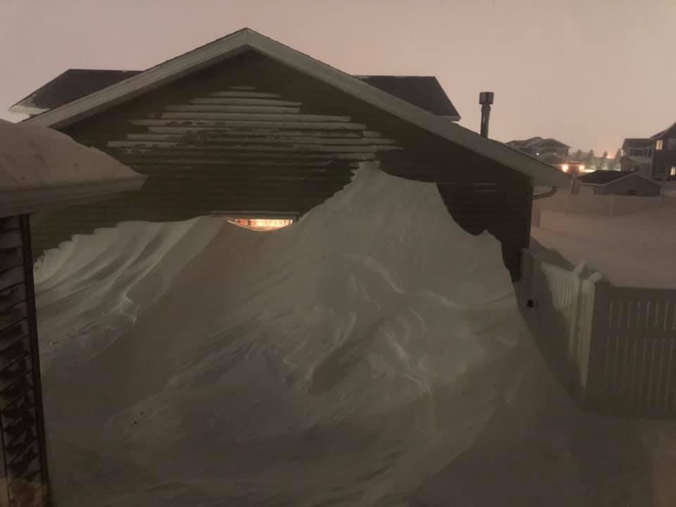 |
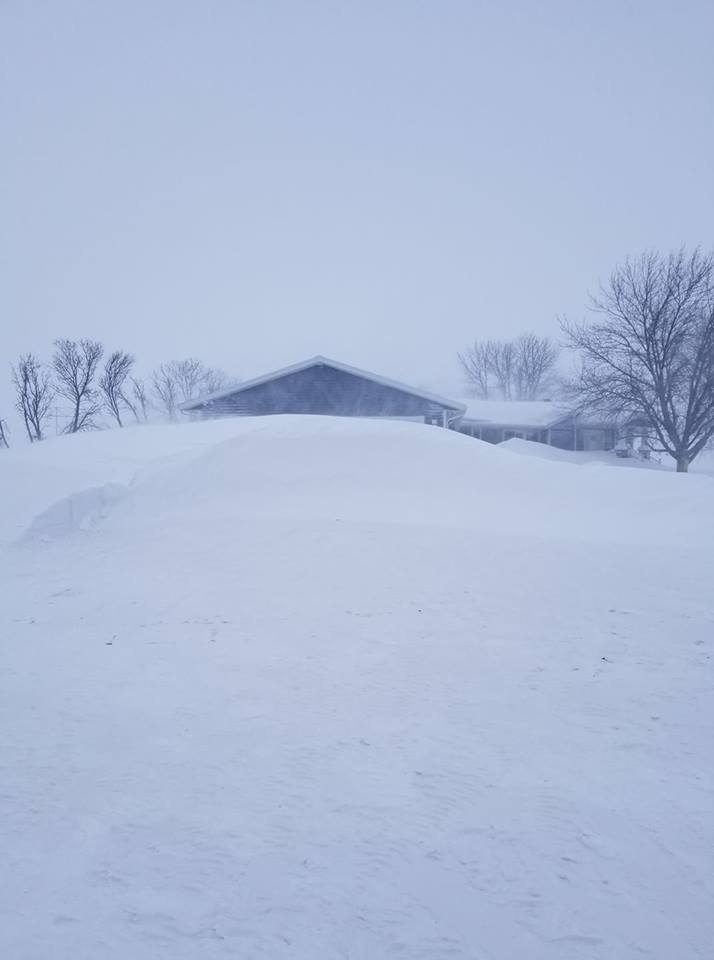
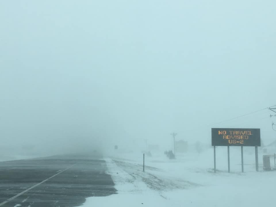
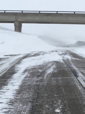
| This event produced large snow drifts. Here is a snow drift almost up to the roof of this house near Abercrombie, ND. Photo by Jamie Beyer. | Travel was severely disrupted for the majority of February 7. This photo shows blizzard conditions and drifting on US Highway 2 just west of Grand Forks, ND. Photo by Matthew Leiphon. | This large drift extended into Interstate 94 near Casselton, ND. Photo courtesy of North Dakota Highway Patrol |
A large drift developed on the side of this house southern Grand Forks, ND. Photo by Amy Decker Peters. |
 |
 |
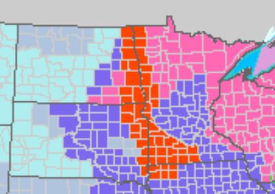 |
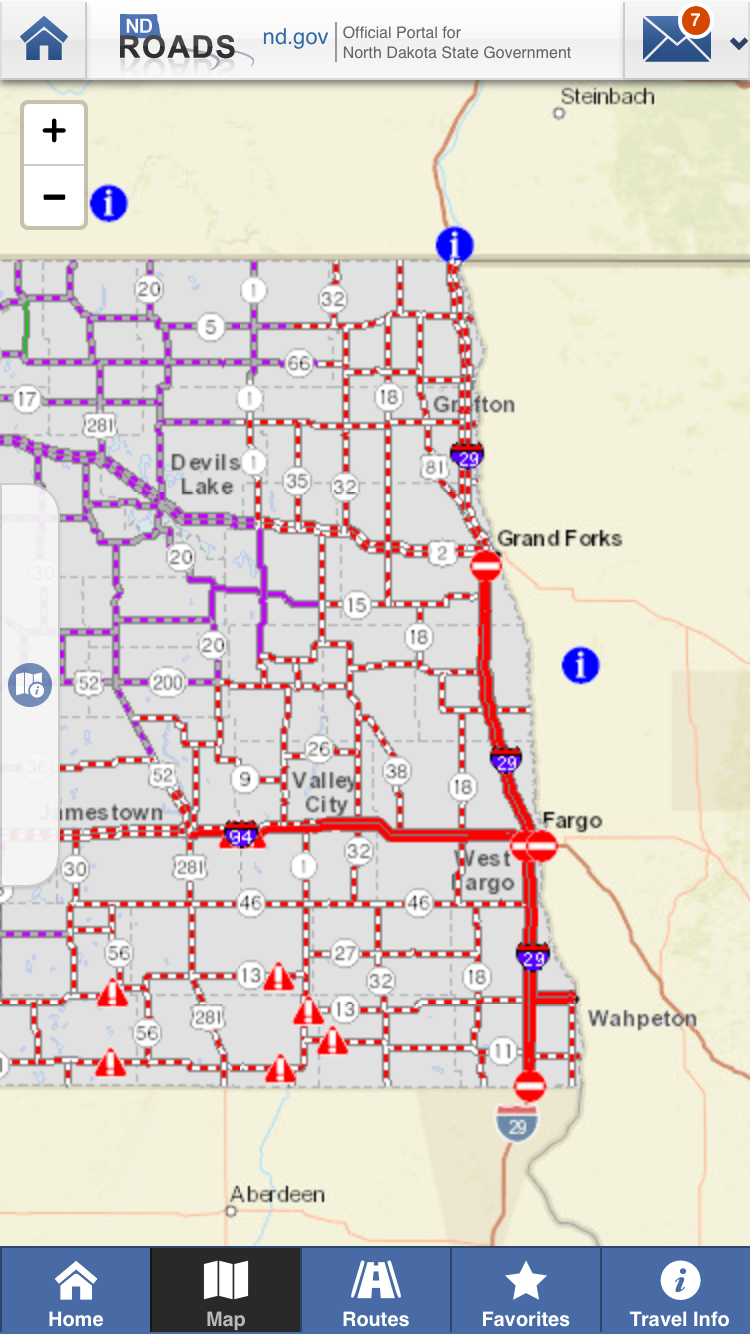
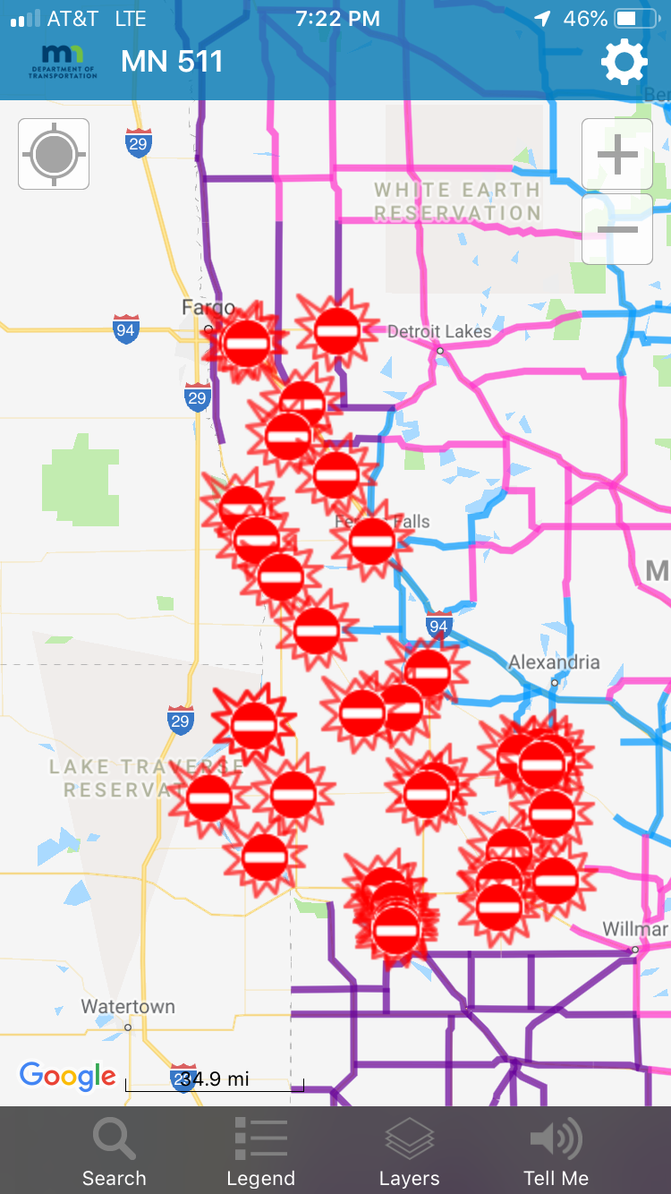
| Because of the extensive drifting and widespread whiteout conditions, I-94 was closed from Jamestown to Fargo and I-29 from Grand Forks to the South Dakota border (the I-29 closure continued into South Dakota all the way to Sioux Falls, SD). Additionally, no travel was advised for the majority of eastern North Dakota. Photo courtesy of NDDOT. | Road closures continued into Minnesota with I-94 closed from Fergus Falls into Fargo. Photo courtesy of MNDOT. | NWS offices around the region issued several warnings and advisories including blizzard warnings (in red) extending from the entire Red River Valley into eastern South Dakota and southwest Minnesota, even into portions of northwest Iowa. |
Radar
Radar Loop Midnight February 6th to Noon February 7th
Environment
Here are animations of the synoptic environment during this event.
300mb Heights, Winds, and Divergence
500mb Heights, Winds, and Temperatures
700mb Heights, Winds, Temperatures, and RH
850mb Heights, Winds, Temperatures, and Dewpoints
Mean Sea-Level Pressure and Surface Winds
Dendritic Layer RH and Omega
 |
Media use of NWS Web News Stories is encouraged! Please acknowledge the NWS as the source of any news information accessed from this site. |
|

