Overview
|
This was an event that came from the Pacific Northwest. As the system approached the northern plains, it moved southeast, strengthened, and slowed a bit. The main impact included heavy snowfall rates (1”/hour) combined with strong winds to produce a 3-8 hour period of winter storm warning / blizzard conditions. |
Impacts
 |
 |
 |
 |
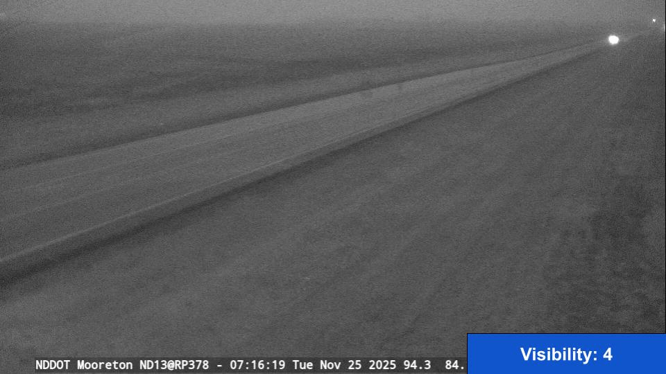
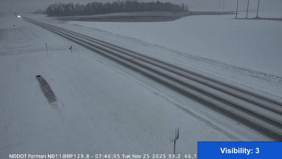
| North Dakota DOT Road Conditions 6pm | Mooreton, ND NDDOT Camera Loop | Forman, ND NDDOT Camera Loop | Blizzard Duration |
 |
 |
 |
 |
| Blowing Snow Conditions at 11a | Blowing Snow Conditions at 1p | Blowing Snow Conditions at 3p | Blowing Snow Conditions at 5p |
Snow/Ice

...SNOWFALL REPORTS...

Location                     Amount    Time/Date
Deer Creek MN 2.0 WSW        8.0 in    0600 AM 11/26
Lake Park MN 9.9 S           7.8 in    0900 AM 11/26
Wadena MN 1.0 NE             7.4 in    0800 AM 11/26
Rothsay                      7.0 in    0800 PM 11/25
Woodland Park MN 2.1 W       7.0 in    0700 AM 11/26
1 NE Verndale                7.0 in    0700 AM 11/26
Ottertail MN                 6.5 in    0250 AM 11/26
Ashby                        6.5 in    0420 AM 11/26
Staples MN 3.5 N             6.5 in    0745 AM 11/26
Mcleod ND 3 E                6.5 in    0900 AM 11/26
New York Mills MN            6.4 in    0730 AM 11/26
Pelican Rapids               6.3 in    0445 PM 11/25
Forman                       6.0 in    0900 PM 11/25
Wahpeton                     6.0 in    0900 PM 11/25
2 S Fargo                    5.8 in    0828 PM 11/25
Park Rapids MN 1.0 NNE       5.5 in    0700 AM 11/26
Laporte MN 8.0 NNW           5.0 in    0515 AM 11/26
Ulen                         5.0 in    0522 AM 11/26
Fargo ND 3.6 NNE             5.0 in    0700 AM 11/26
Lisbon ND                    5.0 in    0700 AM 11/26
Naytahwaush                  4.9 in    1031 PM 11/25
Park Rapids MN 2.0 NNW       4.8 in    0700 AM 11/26
Bemidji MN 7.8 ENE           4.6 in    0700 AM 11/26
Park Rapids MN 3.7 N         4.2 in    0700 AM 11/26
4 N Muskoda                  4.1 in    0710 AM 11/26
Forman                       4.0 in    1235 PM 11/25
Detroit Lakes MN 5.7 N       4.0 in    0430 AM 11/26
West Fargo 2.1 SSW           4.0 in    0700 AM 11/26
Menahga MN 4.0 W             4.0 in    0700 AM 11/26
Detroit Lakes MN 0.5 NNW     4.0 in    0700 AM 11/26
Hawley MN 5.2 WNW            4.0 in    0700 AM 11/26
1 SSE Fargo                  3.6 in    1026 PM 11/25
Fargo ND 6.3 S               3.5 in    0700 AM 11/26
Park Rapids MN 0.8 N         3.5 in    0800 AM 11/26
Fargo ND 3 S                 3.2 in    0600 PM 11/25
Fargo ND 3 S                 3.2 in    1210 AM 11/26
Moorhead MN 6.1 NNW          3.2 in    0800 AM 11/26
1 SW Wahpeton                3.0 in    1241 PM 11/25
1 SE Bemidji                 3.0 in    0527 AM 11/26
Rollag 4.6 S                 3.0 in    0700 AM 11/26
Twin Valley MN 0.1 NE        3.0 in    0800 AM 11/26
Erksine MN 7.6 SSW           2.5 in    0830 AM 11/26
5 NNE Luverne                2.2 in    0708 PM 11/25
Forman                       2.0 in    0925 AM 11/25
3 N Oberon                   1.8 in    1115 AM 11/25
3 S Fargo                    1.6 in    1200 PM 11/25
Gonvick MN 0.2 ENE           1.5 in    0700 AM 11/26
Cooperstown ND 0.4 WNW       1.5 in    0755 AM 11/26
4 SSE Grand Forks            1.0 in    1200 PM 11/25
Shelly MN 0.2 SW             1.0 in    0800 AM 11/26
Grand Forks ND (NWS)         0.7 in    1210 AM 11/26
1 WNW Grand Forks            0.5 in    1200 PM 11/25
Devils Lake                  0.5 in    0656 AM 11/26
Larimore ND 0.4 SE           0.5 in    0700 AM 11/26
Grand Forks AP ND            0.4 in    1130 PM 11/25
Warroad MN 4 W               0.3 in    1000 PM 11/25
Grand Forks ND 3.9 N         0.3 in    0800 AM 11/26
Warroad MN 1.8 WNW           0.1 in    0700 AM 11/26
East Grand Forks MN 4.9 N     T in     0700 AM 11/26
Lake Bronson Dam MN           T in     0800 AM 11/26
Langdon ND 1 E                T in     0808 AM 11/26

Observations are collected from a variety of sources with varying
equipment and exposures. We thank all volunteer weather observers
for their dedication. Not all data listed are considered official.
No Ice Fell During This Event.
Storm Reports
...HIGHEST WIND REPORTS...

Location                     Speed     Time/Date
Herman MN DOT                73 MPH    0600 PM 11/25
Kent MN DOT                  61 MPH    0550 PM 11/25
Tenney MN DOT                55 MPH    0430 PM 11/25
Wahpeton AP ND               52 MPH    0415 PM 11/25
Fergus Falls AP  MN          51 MPH    0445 PM 11/25
Campbell MN NDAWN            49 MPH    0455 PM 11/25
Gwinner AP ND                48 MPH    0155 PM 11/25
Mooreton ND NDAWN            48 MPH    0215 PM 11/25
Wahpeton ND NDAWN            48 MPH    0250 PM 11/25
Fargo AP ND                  48 MPH    0445 PM 11/25
Argyle MN 5 WSW              48 MPH    0155 PM 11/25
Brampton ND NDAWN            47 MPH    0210 PM 11/25
Rothsay MN DOT               47 MPH    0320 PM 11/25
Dilworth MN DOT              46 MPH    0455 PM 11/25
Osage MN DOT                 45 MPH    0935 AM 11/26
Frazee MN DOT                44 MPH    0810 PM 11/25
Lisbon ND NDAWN              43 MPH    0155 PM 11/25
Prosper ND NDAWN             43 MPH    0130 PM 11/25
Fergus Falls MN DOT          43 MPH    0240 AM 11/26
Moorhead MN 1 NE             43 MPH    1230 PM 11/25
Moorhead AP MN               43 MPH    0535 PM 11/25
E Grand Forks MN DOT         42 MPH    1125 PM 11/25
Beltrami MN DOT              42 MPH    1205 AM 11/26
Sabin MN NDAWN               42 MPH    0530 PM 11/25
Grand Forks AP ND            41 MPH    0438 PM 11/25
Halstad MN DOT               41 MPH    0430 PM 11/25
Park Rapids AP MN            41 MPH    0534 AM 11/26
Red Lake MN DOT              41 MPH    0925 AM 11/26
Mayville ND 1 W              40 MPH    0715 PM 11/25
Cooperstown AP ND            40 MPH    1115 AM 11/25
Moorhead MN DOT              40 MPH    0320 PM 11/25

Observations are collected from a variety of sources with varying
equipment and exposures. We thank all volunteer weather observers
for their dedication. Not all data listed are considered official.
Radar
 |
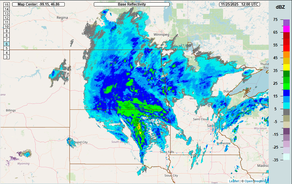 |
| 1st Half of Event | 2nd Half of Event |
Environment
 |
 |
 |
| TropicalTidBits.com GFS Analysis 250mb Evolution | TropicalTidBits.com GFS Analysis 500mb Evolution | TropicalTidBits.com GFS Analysis Surface Evolution |
 |
Media use of NWS Web News Stories is encouraged! Please acknowledge the NWS as the source of any news information accessed from this site. |
|

