Overview
|
A well defined mesoscale complex developed across North Dakota and spread into the Red River valley in the early morning hours of Friday August 8 2025. Amongst the squall line of 60 to 80 mph wind gusts several brief QLCS tornadoes developed, enhancing the destructive nature of the winds. Additionally, strong winds destroyed bins at the Thompson and Finley elevators. |
Tornadoes
Select a tornado from the table to zoom into the track and view more information. The default table view is limited to 8 tracks, but can be scrolled by a mouse wheel or dynamically expanded. Additionally, the table can fill the entire window by clicking the small circular expanding arrow icon at the very top right of the table and returned to its original size by clicking the button again. The side information panel that opens over the map can be closed using the "X" on the upper right corner of the pop-up. Zoom into the map and click damage points to see detailed information and pictures from the surveys.
|
NOTE: times shown below are local to your device's time zone. |

The Enhanced Fujita (EF) Scale classifies tornadoes into the following categories:
| EF0 Weak 65-85 mph |
EF1 Moderate 86-110 mph |
EF2 Significant 111-135 mph |
EF3 Severe 136-165 mph |
EF4 Extreme 166-200 mph |
EF5 Catastrophic 200+ mph |
 |
|||||
| Tornadoes that fail to impact any ratable damage indicators on the EF-Scale are rated EF-Unknown (EF-U) | |||||
Radar
Header
 |
| Radar reflectivity (MRMS RALA) - 9 PM CDT August 7, 2025, to 8 AM CDT August 8, 2025. |
 |
| Radar imagery of Grand Forks area QLCS tornadoes (via KMVX in Mayville, ND - does not show Larimore South tornado). Notice several line-embedded circulations associated with weak tornadoes, including one that went through the center of Grand Forks, ND. Top left: Base reflectivity (0.5 deg). Top right: Base velocity (0.5 deg). Bottom left: Normalized rotation (NROT - 0.5 deg). Bottom right: Storm relative velocity (from 238 degrees at 57 knots - 0.5 deg). |
Storm Reports
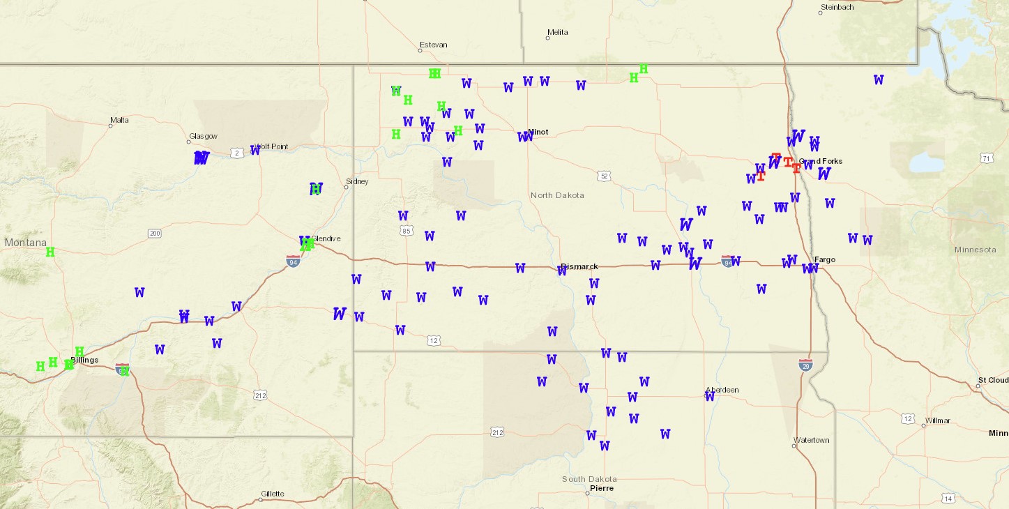 |
| Local Storm Reports (LSRs) issued from August 7, 2025. Find them here. |
Public Information Statement issued Saturday August 9, 2025, regarding tornadoes around the Grand Forks, ND, area:
Public Information Statement...DELAYED
National Weather Service Grand Forks ND
349 PM CDT Sat Aug 9 2025

...NWS Damage Survey for 08/08/2025 QLCS Tornado Event - Initial Issuance...

.Overview...A strong line of storms moved through eastern North Dakota
and northwestern Minnesota through the early morning hours of Friday,
August 8th 2025. This line of storms produced several brief tornadoes
across the area on the leading edge. with many of the tornadoes likely
rain-wrapped or intermittently touching down. Additional points of
damage have been surveyed and future tracks may be possible as we
continue to review all available data sources.

Reissuing for a correction for the Larimore South tornado.

.Grand Forks/East Grand Forks...

Rating:                 EF1
Estimated Peak Wind:    100 mph
Path Length /statute/:  4.05 miles
Path Width /maximum/:   100 yards
Fatalities:             0
Injuries:               0

Start Date:             08/08/2025
Start Time:             04:14 AM CDT
Start Location:         2 SSW Grand Forks / Grand Forks County / ND
Start Lat/Lon:          47.8895 / -97.0834

End Date:               08/08/2025
End Time:               04:19 AM CDT
End Location:           1 S East Grand Forks / Polk County / MN
End Lat/Lon:            47.9144 / -97.0122

Survey Summary:
Intermittent path through town with higher end damage concentrated
along path of correlated broad radar signature.


.Larimore South...

Rating:                 EF1
Estimated Peak Wind:    95 mph
Path Length /statute/:  1.29 miles
Path Width /maximum/:   100 yards
Fatalities:             0
Injuries:               0

Start Date:             08/08/2025
Start Time:             03:48 AM CDT
Start Location:         3 SSW Larimore / Grand Forks County / ND
Start Lat/Lon:          47.8658 / -97.649

End Date:               08/08/2025
End Time:               03:50 AM CDT
End Location:           2 S Larimore / Grand Forks County / ND
End Lat/Lon:            47.8762 / -97.626

Survey Summary:
Radar TDS and ground survey suggests a brief rain wrapped tornado
developed within the squall line. Will reassess the track when
high resolution satellite data comes in.

.Mekinock...

Rating:                 EF1
Estimated Peak Wind:    105 mph
Path Length /statute/:  0.13 miles
Path Width /maximum/:   0 yards
Fatalities:             0
Injuries:               0

Start Date:             08/08/2025
Start Time:             04:05 AM CDT
Start Location:         Mekinock / Grand Forks County / ND
Start Lat/Lon:          48.0156 / -97.3665

End Date:               08/08/2025
End Time:               04:06 AM CDT
End Location:           Mekinock / Grand Forks County / ND
End Lat/Lon:            48.0162 / -97.3637

Survey Summary:
Brief touchdown currently surveyed. Will reassess the track when
high resolution satellite data comes in.

.North of Grand Forks...

Rating:                 EF1
Estimated Peak Wind:    110 mph
Path Length /statute/:  3.79 miles
Path Width /maximum/:   50 yards
Fatalities:             0
Injuries:               1

Start Date:             08/08/2025
Start Time:             04:12 AM CDT
Start Location:         6 SSW Manvel / Grand Forks County / ND
Start Lat/Lon:          47.9808 / -97.2016

End Date:               08/08/2025
End Time:               04:17 AM CDT
End Location:           5 SSE Manvel / Grand Forks County / ND
End Lat/Lon:            48.0024 / -97.1264

Survey Summary:
This tornado likely rain wrapped intermittently produced damage
across its nearly 4 mile long path with wind speeds up to 110mph.


&&

EF Scale: The Enhanced Fujita Scale classifies tornadoes into the
following categories:

EF0.....65 to 85 mph
EF1.....86 to 110 mph
EF2.....111 to 135 mph
EF3.....136 to 165 mph
EF4.....166 to 200 mph
EF5.....>200 mph

NOTE:
The information in this statement is preliminary and subject to
change pending final review of the events and publication in
NWS Storm Data.


$$
-->
 |
Media use of NWS Web News Stories is encouraged! Please acknowledge the NWS as the source of any news information accessed from this site. |
|

