Overview
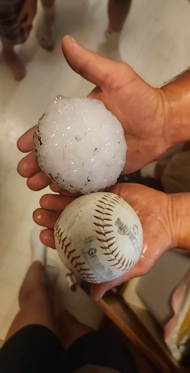
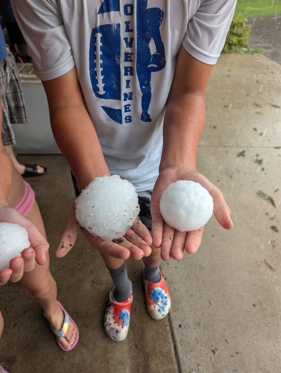
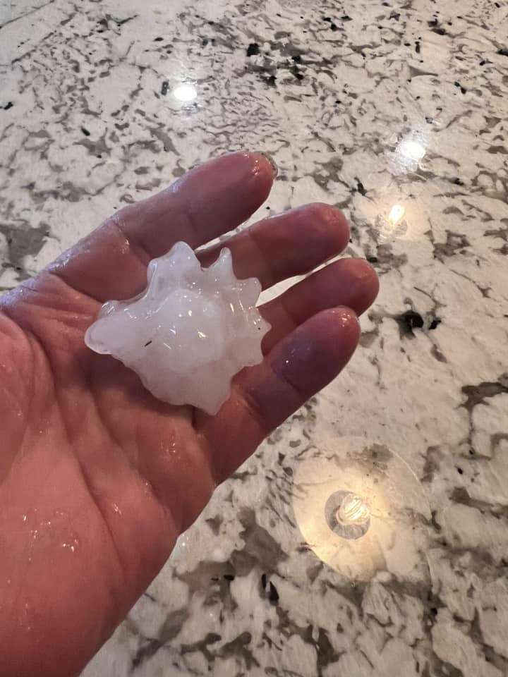
On a day that started as a slight risk as far north as west central and central Minnesota early day convection somewhat stole the show with various reports ranging from quarter to golf ball size hail near Blackduck MN. Around 5PM the first storm of the afternoon formed near Bemidji with subsequent more rigorous attempts at convection further south in Hubbard and Wadena counties by 6pm. At 6:30 pm the first report of baseball (2.75") sized hail was made in Wadena with later reports of up to softball (4") size hail. All in all about 15 minutes worth of hail occurred in the town of Wadena with most of town seeing golf ball (1.75") sized hail.Photos & Video
This event produced baseball sized hail.
 |
 |
 |
|
Sierra Rach Wadena |
Marty Penner Northeast of Wadena |
Diane Line Verndale |
 |
| Storm Report Map |
796
NWUS53 KFGF 050134
LSRFGF

Preliminary Local Storm Report...Summary
National Weather Service Grand Forks ND
834 PM CDT Sun Aug 4 2024

..TIME...   ...EVENT...      ...CITY LOCATION...     ...LAT.LON...
..DATE...   ....MAG....      ..COUNTY LOCATION..ST.. ...SOURCE....
            ..REMARKS..

0630 PM     Hail             1 N Wadena              46.45N 95.14W
08/03/2024  M4.00 Inch       Wadena             MN   Public

            Facebook report of mostly baseball sized
            stones with a few as large as softballs, no
            hail stones smaller than golf balls.

0640 PM     Hail             1 ESE Wadena            46.43N 95.11W
08/03/2024  M4.00 Inch       Wadena             MN   Public

            Corrects previous hail report from 1 ESE
            Wadena. Mostly ping pong balls, but the
            largest stones were up to softball in size.

0638 PM     Hail             Wadena                  46.44N 95.13W
08/03/2024  M3.00 Inch       Wadena             MN   Trained Spotter

            Largest hailstones only lasted 3 minutes,
            but smaller hail still ongoing at time of
            call.

0650 PM     Hail             Wadena                  46.43N 95.14W
08/03/2024  M2.50 Inch       Wadena             MN   Public


1210 PM     Hail             Blackduck               47.73N 94.55W
08/03/2024  M1.75 Inch       Beltrami           MN   Emergency Mngr


0620 PM     Hail             Staples                 46.39N 94.81W
08/03/2024  M1.75 Inch       Wadena             MN   Law Enforcement

            Delayed Report. Location Estimated.

0625 PM     Hail             Staples                 46.47N 94.81W
08/03/2024  M1.75 Inch       Wadena             MN   Law Enforcement

            Reported golf ball sized hail ongoing.

0638 PM     Hail             4 NE Wadena             46.49N 95.09W
08/03/2024  E1.75 Inch       Wadena             MN   Public

            Hail and heavy rainfall, with the largest
            stones being the size of golf balls.

0645 PM     Hail             1 N Verndale            46.41N 95.02W
08/03/2024  M1.75 Inch       Wadena             MN   Public

            Hail lasted about 15 minutes.

0830 AM     Hail             Skime                   48.55N 95.60W
08/03/2024  M1.25 Inch       Roseau             MN   Public


1050 AM     Hail             Warroad                 48.91N 95.32W
08/03/2024  M1.25 Inch       Roseau             MN   Public


1045 AM     Hail             3 NW Warroad            48.93N 95.36W
08/03/2024  M1.00 Inch       Roseau             MN   Public


1107 AM     Hail             5 N Roosevelt           48.88N 95.10W
08/03/2024  E1.00 Inch       Roseau             MN   Public

            Hail was quarter sized or slightly larger.

1210 PM     Hail             1 N Blackduck           47.74N 94.55W
08/03/2024  M1.00 Inch       Beltrami           MN   Trained Spotter

            Garden Damaged. Hail lasted 5 minutes.

0440 PM     Hail             Bemidji                 47.47N 94.88W
08/03/2024  M1.00 Inch       Beltrami           MN   Emergency Mngr

            EM reports hail around town varying from
            nickel to quarter sized.

0608 PM     Hail             7 ESE Blue Grass        46.50N 94.88W
08/03/2024  E1.00 Inch       Wadena             MN   Public

            Facebook report.

0628 PM     Hail             6 N Wadena              46.53N 95.14W
08/03/2024  M1.00 Inch       Wadena             MN   Trained Spotter


0645 PM     Hail             Verndale                46.40N 95.01W
08/03/2024  M1.00 Inch       Wadena             MN   Law Enforcement

            Still hailing at time of the report.

0940 AM     Hail             4 NNW Waskish           48.21N 94.55W
08/03/2024  E0.88 Inch       Beltrami           MN   Park/Forest Srvc

            Report of hail damage to a camper vent north
            of Waskish.

0945 AM     Hail             2 NNW Waskish           48.20N 94.53W
08/03/2024  E0.88 Inch       Beltrami           MN   Public

            Hail accumulated. Time estimated from radar.

1232 PM     Hail             2 N Holt                48.33N 96.19W
08/03/2024  E0.50 Inch       Marshall           MN   Public

            Report from mPING: Half-inch (0.50 in.).

0217 PM     Hail             1 W East Grand Forks    47.92N 97.03W
08/03/2024  E0.50 Inch       Grand Forks        ND   Public

            Report from mPING: Half-inch (0.50 in.).

0555 PM     Hail             Blue Grass              46.54N 95.01W
08/03/2024  E0.50 Inch       Wadena             MN   Public

            Report from mPING: Half-inch (0.50 in.).

0646 PM     Hail             4 N Verndale            46.46N 95.01W
08/03/2024  E0.50 Inch       Wadena             MN   Public

            Report from mPING: Half-inch (0.50 in.).
Radar
Radar picked up on high reflectivity values (>65 dbz) and related lower correlation coefficient values (~85). The core of the system traveling through southeastern Wadena county picked up on a small rotation signature.
.gif) |
| 4 Panel showing (left - right, top - bottom) Base Reflectivity, Correlation Coefficient, Base Velocity, and Differential Reflectivity |
Environment
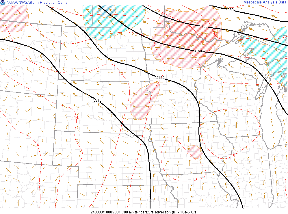
This event was driven largely by surface convergence along the warm front extending from a surface low (Fig. 1). Another forcing mechanism for this event was a shortwave trough at 700mb (Fig. 2), along with warm air advection. The warming temperatures primed the environment for convective development. The cold air advection which quickly followed pushed the system further southeast. Figure 3 shows the converging winds were converging - north/northeasterlies in northwestern MN, and south/southeasterlies in southwestern MN.
 |
 |
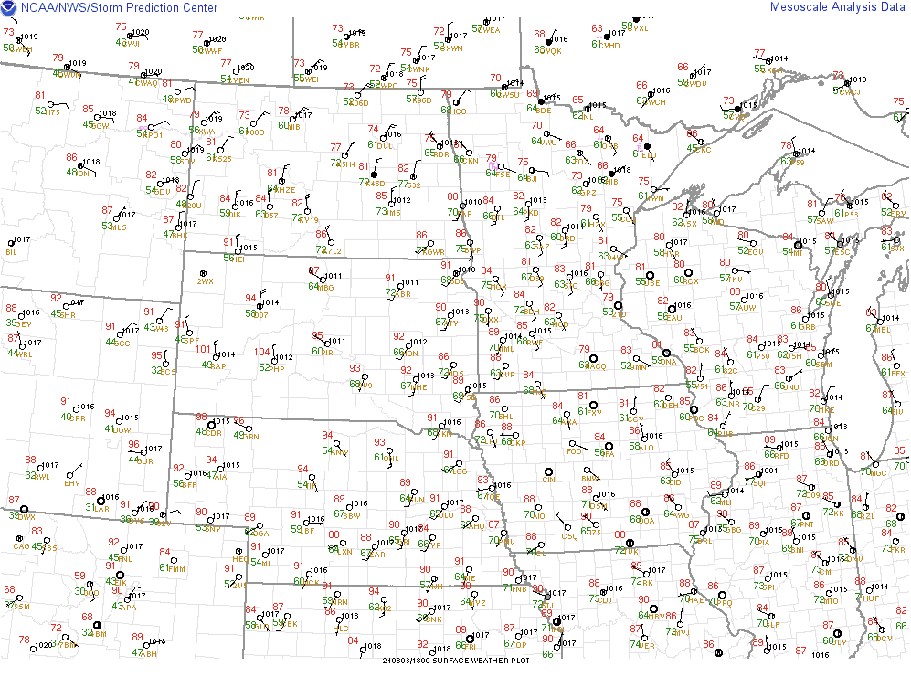 |
| Figure 1: WPC Surface Analysis for 18Z | Figure 2: 700mb Temperature Advection | Figure 3: Surface Observations. |
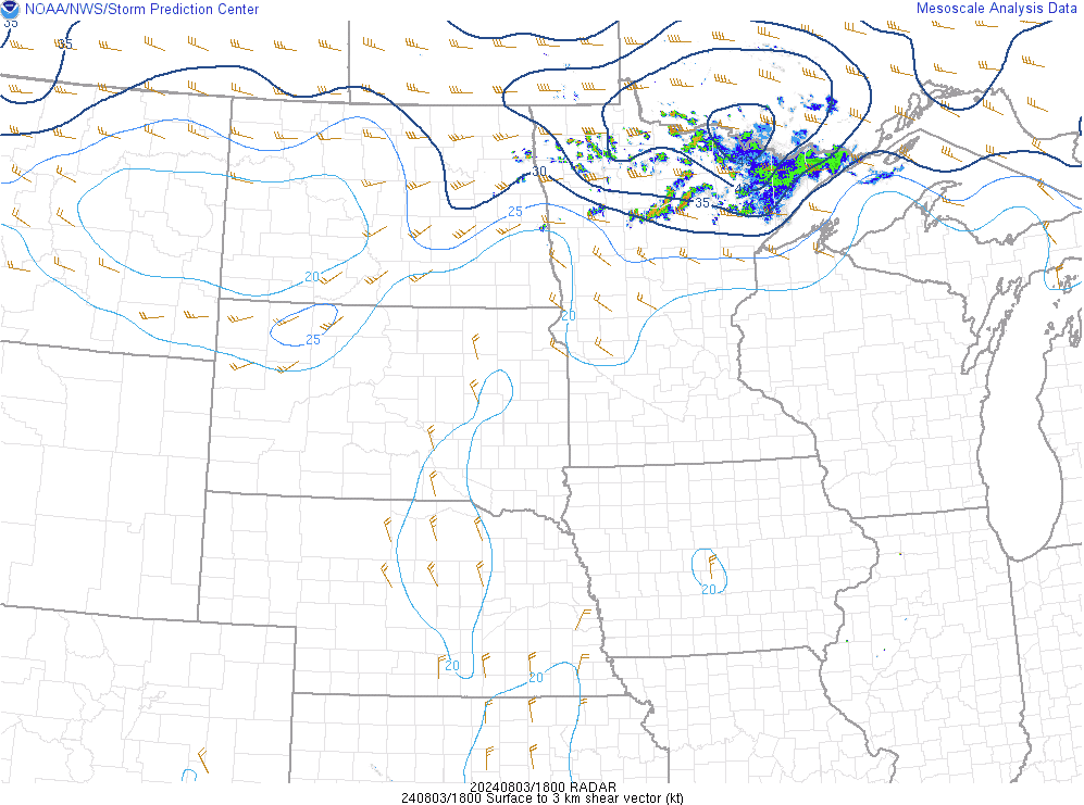
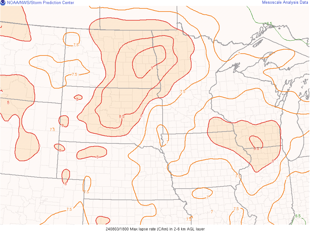
This event exhibited low level (surface - 3km) shear values greater than 40 kts (Fig. 4), which contributed to the large hail production. In addition to shear, instability for this event was also optimal. Lapse rates (Fig. 5) greater than 8.5 C/km, mixed layer CAPE values greater than 3000 J/kg, and a pocket of reduced CIN (Fig. 6), supported the instability needed for convective development. Figure 7 shows how moisture convergence also helped the system, likely due to warmer temperatures being advected into the area leading to more evaporation.
 |
 |
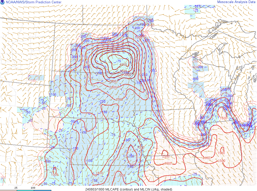 |
| Figure 4: Surface - 3km Shear, Radar Reflectivity | Figure 5: 700mb - 500mb Lapse Rates | Figure 6: MLCAPE (Contour), MLCIN (Shaded) |
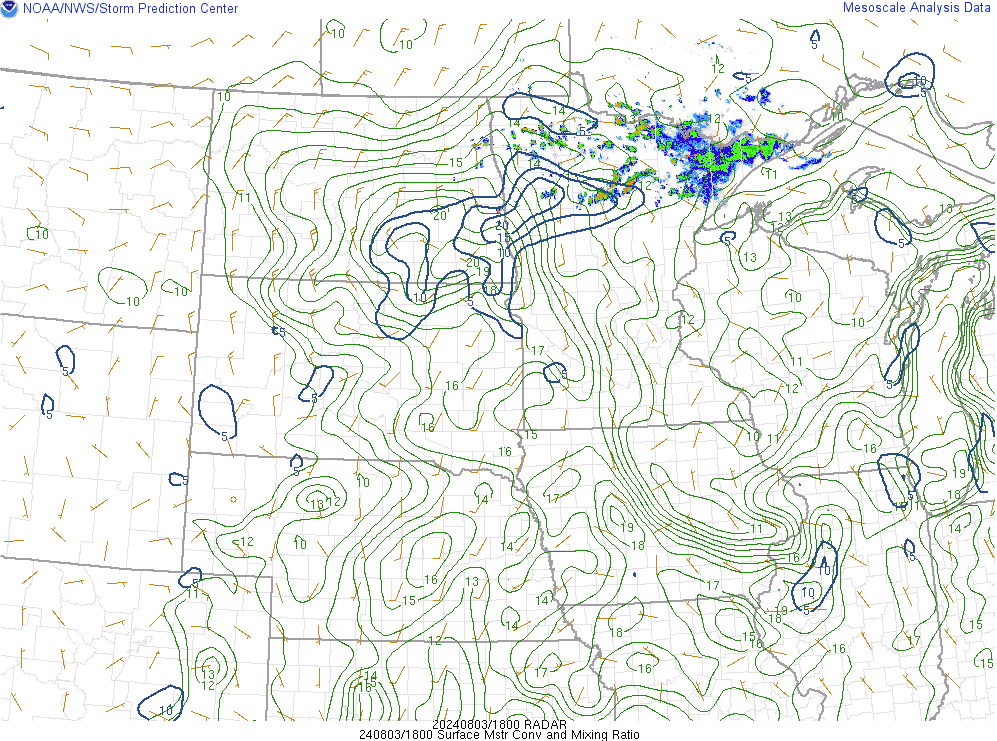 |
| Figure 7: Surface Moisture Convergence, Radar Reflectivity |
 |
Media use of NWS Web News Stories is encouraged! Please acknowledge the NWS as the source of any news information accessed from this site. |
|

