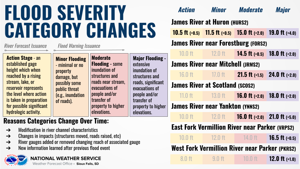
A combination of recent in-person river surveys, LiDAR analysis,
archived satellite imagery, impacts from previous flood events and
consultation with local state emergency management officials
have concluded that raising the flood severity categories
at select river gauge locations along the James and Vermillion
Rivers in southeastern South Dakota would better align the
categories with the noted impacts to the public. These changes in
impacts over the past years may be caused by such factors as
structures being moved out of the floodplain, roads and highways
being raised or new river gauge installations impacting the river
reach of an associated gauge. Below are the impacted river gauge
locations and new category levels:

James River at Huron (HURS2)
Previous Action Stage: 10.0 ft      New Action Stage: 10.5 ft
Previous Minor Stage: 11.0 ft       New Minor Stage: 11.5 ft
Previous Moderate Stage: 13.0 ft    New Moderate Stage: 15.0 ft
Previous Major Stage: 15.0 ft       New Major Stage: 19.0 ft

James River near Forestburg (FORS2)
Previous Action Stage: 10.0 ft      New Action Stage: No change
Previous Minor Stage: 12.0 ft       New Minor Stage: No change
Previous Moderate Stage: 14.0 ft    New Moderate Stage: 14.5 ft
Previous Major Stage: 16.0 ft       New Major Stage: 18.0 ft

James River near Mitchell (JRMS2)
Previous Action Stage: 16.0 ft      New Action Stage: No change
Previous Minor Stage: 17.0 ft       New Minor Stage: No change
Previous Moderate Stage: 20.0 ft    New Moderate Stage: 21.5 ft
Previous Major Stage: 22.0 ft       New Major Stage: 24.0 ft

James River at Scotland (SCOS2)
Previous Action Stage: 11.0 ft      New Action Stage: No change
Previous Minor Stage: 13.0 ft       New Minor Stage: No change
Previous Moderate Stage: 14.0 ft    New Moderate Stage: 16.0 ft
Previous Major Stage: 16.0 ft       New Major Stage: 18.0 ft

James River near Yankton (YNNS2)
Previous Action Stage: 10.0 ft      New Action Stage: No change
Previous Minor Stage: 12.0 ft       New Minor Stage: No change
Previous Moderate Stage: 14.0 ft    New Moderate Stage: 16.0 ft
Previous Major Stage: 16.0 ft       New Major Stage: 21.0 ft

East Fork Vermillion near Parker (VRPS2)
Previous Action Stage: 10.0 ft      New Action Stage: No change
Previous Minor Stage: 12.0 ft       New Minor Stage: No change
Previous Moderate Stage: 14.0 ft    New Moderate Stage: No change
Previous Major Stage: 16.0 ft       New Major Stage: 16.5 ft

West Fork Vermillion near Parker (PKRS2)
Previous Action Stage: 8.0 ft       New Action Stage: No change
Previous Minor Stage: 9.0 ft        New Minor Stage: No change
Previous Moderate Stage: 10.0 ft    New Moderate Stage: No change
Previous Major Stage: 11.0 ft       New Major Stage: 12.0 ft

River forecasts will continue to issued at and above Action Stage
and Flood Warnings (FLW) will continue to be issued for observed
or forecast levels at or above Minor Stage. In both cases, the
only change from previous thresholds for these two services will
be at the James River at Huron (HURS2) at which Action and Minor
Stage are both being raised by 0.5 ft.

This change will be effective December 14, 2023.

If you have any questions or comments, please contact:

Andrew Kalin
National Weather Service Sioux Falls, SD
26 Weather Lane
Sioux Falls, SD 57104
605-330-4247
andrew.kalin@noaa.gov


 Weather Story
 Weather Map
 Local Radar
 Follow us on YouTube