Overview
|
Heavy lake effect snow fell over the lake shore counties of northeast Wisconsin on January 14-15, 2018, as a prolonged period of easterly winds developed ahead of a low pressure system. More than a foot of snow fell across most of Door County, with more than eight inches across much of Kewaunee and Manitowoc counties. A general snowfall of two to four inches was reported across the remainder of north-central and northeast Wisconsin as the low pressure system moved across the state. The cold air mass resulted in a dry, fluffy snow.
See tabs below for radar and snow report information. Click any image for larger view. |
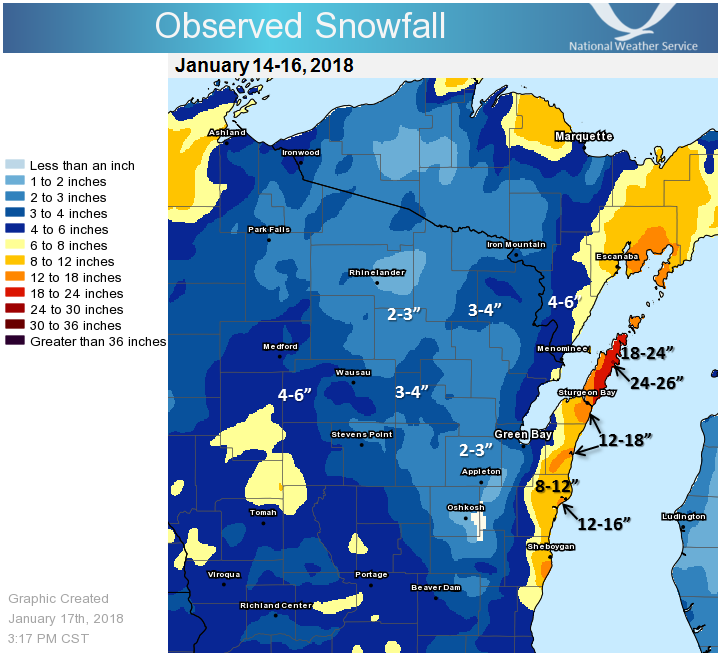 Two-Day Observed Snowfall |
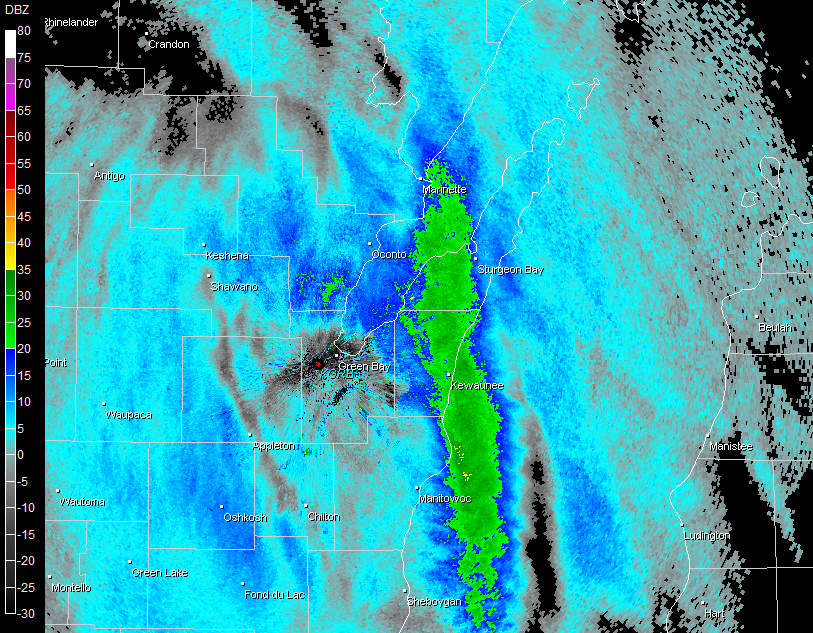
Radar:
Reflectivity Images from NWS Green Bay
 |
 |
 |
| Reflectivity: 2:00 AM January 15 | Reflectivity: 6:04 AM January 15 | Reflectivity: 10:01 AM January 15 |
  |
||
Two-Day Storm Totals
Location                     Amount    Time/Date       Lat/Lon

...Wisconsin...

...Brown County...
Flintville                   4.3 in    0700 AM 01/16   44.66N/88.12W
Suamico                      3.5 in    0700 AM 01/16   44.60N/88.10W
NWS Green Bay                3.1 in    0600 AM 01/16   44.50N/88.11W
Allouez                      2.7 in    0545 AM 01/16   44.47N/87.97W
Wrightstown                  2.1 in    0700 AM 01/16   44.33N/88.17W

...Calumet County...
Brillion                     4.0 in    0630 AM 01/16   44.18N/88.07W
New Holstein - East - WWTP   3.0 in    0750 AM 01/16   43.95N/88.08W
Darboy 3 SE                  2.5 in    0700 AM 01/16   44.20N/88.33W

...Door County...
Ephraim 5 SE - North Bay     25.0 in   0630 AM 01/16   45.13N/87.07W
3 ENE Baileys Harbor         20.5 in   0700 AM 01/16   45.09N/87.07W
Ellison Bay 1 ENE            19.3 in   0700 AM 01/16   45.26N/87.03W
Washington Island            16.0 in   0700 AM 01/16   45.36N/86.89W
Sister Bay 1 N               16.0 in   0700 AM 01/16   45.20N/87.11W
Forestville 4 E              11.0 in   0800 AM 01/16   44.70N/87.40W

...Florence County...
Spread Eagle 1 NW            3.0 in    0700 AM 01/16   45.89N/88.14W

...Forest County...
Argonne 1.5 NW               2.3 in    0725 AM 01/16   45.67N/88.90W

...Kewaunee County...
Kewaunee-southwest           11.1 in   0440 AM 01/16   44.45N/87.51W
Kewaunee                     11.1 in   0700 AM 01/16   44.46N/87.51W

...Langlade County...
Antigo 1 SSW                 3.0 in    0800 AM 01/16   45.13N/89.15W

...Lincoln County...
Merrill 8 W                  3.2 in    0600 AM 01/16   45.18N/89.85W
Merrill 7 W                  3.2 in    0600 AM 01/16   45.18N/89.85W
Rice Reservoir No. 2         1.9 in    0600 AM 01/16   45.54N/89.73W

...Manitowoc County...
Two Rivers                   15.9 in   0700 AM 01/16   44.14N/87.57W
Two Rivers 2 NW              14.5 in   0601 AM 01/16   44.18N/87.58W
Millhome 2 E                 6.9 in    0606 AM 01/16   43.90N/87.91W

...Marathon County...
Mosinee 2 W                  4.0 in    0700 AM 01/16   44.77N/89.73W
Stratford 1 NW               3.8 in    0600 AM 01/16   44.82N/90.09W
Dancy 1 NNW                  3.7 in    0600 AM 01/16   44.70N/89.70W
Wausau-Northeast             3.7 in    0545 AM 01/16   44.97N/89.62W

...Marinette County...
Peshtigo                     5.5 in    0730 AM 01/16   45.03N/87.74W
Athelstane                   3.1 in    0600 AM 01/16   45.43N/88.06W
Amberg 9 E                   2.9 in    0615 AM 01/16   45.48N/87.81W

...Oconto County...
Oconto 4 W                   6.0 in    0700 AM 01/16   44.89N/87.96W
Pulaski - WWTP               2.8 in    0700 AM 01/16   44.68N/88.23W

...Oneida County...
Lake Tomahawk 2 SE           3.5 in    0600 AM 01/16   45.81N/89.56W
Rhinelander WJFW TV          2.3 in    1030 PM 01/15   45.62N/89.41W
Rhinelander                  2.0 in    0730 AM 01/16   45.60N/89.45W
Minocqua                     1.8 in    0630 AM 01/16   45.89N/89.73W

...Outagamie County...
Shiocton                     3.2 in    0734 AM 01/16   44.44N/88.58W
Appleton                     2.3 in    0600 AM 01/16   44.35N/88.45W
Appleton WHBY Radio          1.8 in    0805 AM 01/16   44.25N/88.36W

...Portage County...
1 NNE Rudolph                4.0 in    0500 AM 01/16   44.53N/89.79W
Plover                       2.9 in    0700 AM 01/16   44.44N/89.55W
Amherst                      2.8 in    0600 AM 01/16   44.45N/89.29W

...Shawano County...
Angelica                     1.4 in    0700 AM 01/16   44.67N/88.31W

...Vilas County...
Eagle River 4 E              2.6 in    0553 AM 01/16   45.92N/89.15W
Saint Germain                2.6 in    0600 AM 01/16   45.90N/89.49W
St Germain                   2.3 in    0600 AM 01/16   45.92N/89.49W
Eagle River - South          1.8 in    0659 AM 01/16   45.91N/89.24W

...Waushara County...
Hancock Exp Farm             3.8 in    0800 AM 01/16   44.12N/89.54W

...Winnebago County...
Oshkosh 6 S                  2.8 in    0700 AM 01/16   43.94N/88.54W
Wittman Field 2 S            2.8 in    0700 AM 01/16   43.94N/88.54W
Omro 2 SW                    2.2 in    0700 AM 01/16   44.02N/88.78W
Omro 1 WSW                   2.2 in    0700 AM 01/16   44.02N/88.78W
Oshkosh-north                1.9 in    0740 AM 01/16   44.04N/88.54W
Oshkosh                      1.7 in    0700 AM 01/16   44.03N/88.56W

...Wood County...
Pittsville - WWTP            5.3 in    0700 AM 01/16   44.44N/90.13W
Wisconsin Rapids-Southeast   4.2 in    0630 AM 01/16   44.38N/89.80W
Port Edwards 2 E             3.5 in    0745 AM 01/16   44.34N/89.78W

Observations are collected from a variety of sources with varying
equipment and exposures. We thank all volunteer weather observers
for their dedication. Not all data listed are considered official.
 |
Media use of NWS Web News Stories is encouraged! Please acknowledge the NWS as the source of any news information accessed from this site. |
|

