Overview
|
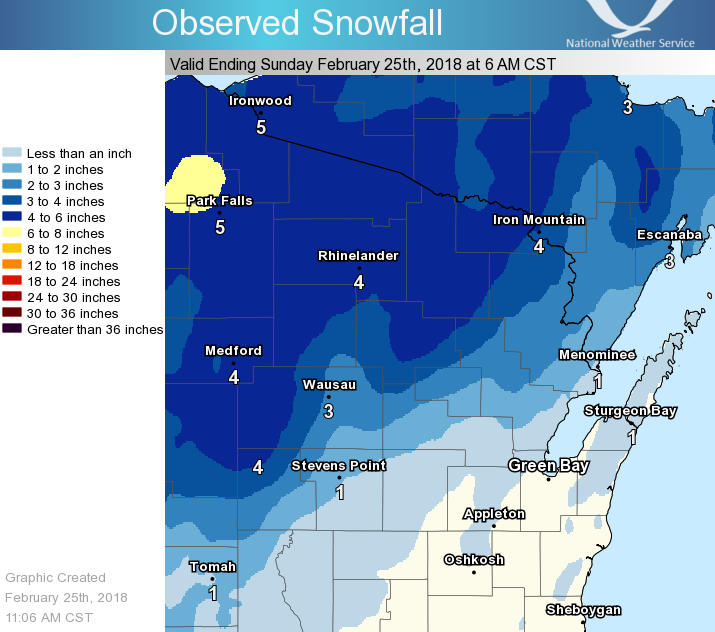
A fast-paced rocky mountain cyclone moved across the region late Saturday night, dropping rain, snow, and some sleet over northeast Wisconsin. Light to moderate snow fell in north-central, central, and far northeast Wisconsin, leaving behind 3 to 6 inches, with a few higher amounts across far north-central Wisconsin. Steady rain fell across the Fox Valley, lakeshore, and portions of central Wisconsin as well. As the system exited the area Sunday morning, gusty west and southwest winds developed, creating minor blowing and drifting snow for the areas with new snow. For areas without new snow, mainly along the Fox Valley and lakeshore, winds gusted up to 50 mph. See the tabs below for more information. |
Snowfall Totals
   ...24-Hour Snowfall Reports...
      (Ending 2/25 at 9:30 AM)

Location                     Amount

...Door County...
Washington Island            1.0 in

...Florence County...
Spread Eagle 1 NW            5.0 in
Spread Eagle                 3.6 in

...Forest County...
Crandon                      5.0 in
Argonne 1.5 NW               4.6 in

...Langlade County...
Summit Lake                  3.9 in

...Lincoln County...
Rice Reservoir No. 2         4.8 in
Merrill 8 W                  3.6 in
Merrill 7 W                  3.6 in

...Marathon County...
Stratford 1 NW               5.0 in
Wausau                       3.8 in
Wausau-Northeast             3.5 in
Mosinee 2 W                  2.8 in
Wausau 1 ENE                 2.7 in
Dancy 1 NNW                  2.4 in
Wausau WSAW TV               1.5 in

...Marinette County...
Crivitz High Falls           2.8 in
Athelstane                   2.5 in

...Oconto County...
Townsend                     3.5 in
Stiles 1 S                   1.2 in
Oconto 4 W                   1.0 in

...Oneida County...
Harshaw                      5.4 in
Lake Tomahawk 2 SE           4.8 in
Minocqua                     4.0 in
Rhinelander WJFW TV          1.0 in

...Portage County...
Rudolph 1 NNE                2.2 in
Plover                       1.4 in
Plover 2 E - Wwtp            1.0 in

...Shawano County...
Pella 3 SE                   1.3 in

...Vilas County...
Saint Germain                6.5 in
Eagle River 4 E              4.6 in
Boulder Junction 9 ENE       4.3 in
Arbor Vitae-Johnson Lake     4.2 in
Eagle River - South          3.5 in
Observations are collected from a variety of sources with varying equipment and exposures. We thank all volunteer weather observers for their dedication. Not all data listed are considered official. |
|
Wind Reports:
...Peak Wind Gusts From 2/24 10 PM to 2/25 10 AM...
Location Speed Time/Date Lat/Lon/Elev (ft.)
...Brown County...
Green Bay Airport 48 MPH 0437 AM 02/25 44.50N/88.11W/680
Wrightstown 34 MPH 0504 AM 02/25 44.33N/88.17W/660
Greenleaf 4 NNE 32 MPH 1128 PM 02/24 44.37N/88.07W/721
...Door County...
Sturgeon Bay Airport 45 MPH 0742 AM 02/25 44.84N/87.42W/725
Washington Island 1 WNW 38 MPH 0715 AM 02/25 45.39N/86.92W/652
Sister Bay 1 NNW 37 MPH 0620 AM 02/25 45.20N/87.12W/590
...Forest County...
Wabeno 2 NNW 33 MPH 0801 AM 02/25 45.46N/88.68W/1560
...Kewaunee County...
Kewaunee 45 MPH 0548 AM 02/25 44.47N/87.50W/584
...Langlade County...
Antigo Airport 40 MPH 0755 AM 02/25 45.15N/89.11W/1522
Antigo 2 ENE 35 MPH 0505 AM 02/25 45.16N/89.11W/1499
...Lincoln County...
Merrill Airport 36 MPH 0355 AM 02/25 45.20N/89.71W/1316
Tomahawk 3 W 35 MPH 0810 AM 02/25 45.47N/89.80W/1449
...Manitowoc County...
Manitowoc Airport 48 MPH 0453 AM 02/25 44.13N/87.68W/650
Wayside 1 SW 37 MPH 0448 AM 02/25 44.23N/87.96W/869
Manitowoc 2 NNE 35 MPH 0607 AM 02/25 44.12N/87.64W/649
...Marathon County...
Wausau Airport 41 MPH 0329 AM 02/25 44.93N/89.63W/1190
Mosinee Airport 30 MPH 0930 AM 02/25 44.78N/89.67W/1276
...Menominee County...
Keshena 2 WNW 30 MPH 0605 AM 02/25 44.89N/88.66W/871
...Oconto County...
Oconto Airport 43 MPH 0635 AM 02/25 44.87N/87.91W/603
Breed 5 NE 35 MPH 0703 AM 02/25 45.12N/88.37W/910
...Oneida County...
Rhinelander Airport 41 MPH 0428 AM 02/25 45.63N/89.47W/1624
...Outagamie County...
Combined Locks 1 W 48 MPH 0440 AM 02/25 44.24N/88.34W/767
Appleton Airport 43 MPH 0435 AM 02/25 44.26N/88.52W/919
Rose Lawn 4 SE 40 MPH 0501 AM 02/25 44.54N/88.25W/830
...Shawano County...
Shawano Airport 38 MPH 0435 AM 02/25 44.79N/88.56W/813
...Vilas County...
Eagle River Airport 39 MPH 0555 AM 02/25 45.93N/89.28W/1644
Arbor Vitae Airport 31 MPH 0455 AM 02/25 45.93N/89.73W/1631
Winchester 3 ENE 30 MPH 0926 AM 02/25 46.23N/89.83W/1640
...Waupaca County...
Scandinavia 50 MPH 0330 AM 02/25 44.46N/89.15W/941
Clintonville Airport 37 MPH 0435 AM 02/25 44.61N/88.73W/823
...Waushara County...
Wautoma Airport 40 MPH 0333 AM 02/25 44.04N/89.30W/859
...Winnebago County...
Zittau 3 SSE 47 MPH 0603 AM 02/25 44.17N/88.77W/790
Omro 44 MPH 0425 AM 02/25 44.03N/88.75W/761
Oshkosh Airport 39 MPH 0456 AM 02/25 43.98N/88.56W/807
Butte Des Morts 2 WSW 36 MPH 0406 AM 02/25 44.07N/88.69W/869
...Wood County...
Marshfield Airport 37 MPH 0300 AM 02/25 44.64N/90.19W/1276
Observations are collected from a
variety of sources with varying equipment
and exposures. We thank all volunteer
weather observers for their dedication.
Not all data listed are considered official.
 |
Media use of NWS Web News Stories is encouraged! Please acknowledge the NWS as the source of any news information accessed from this site. |
|