Overview
|
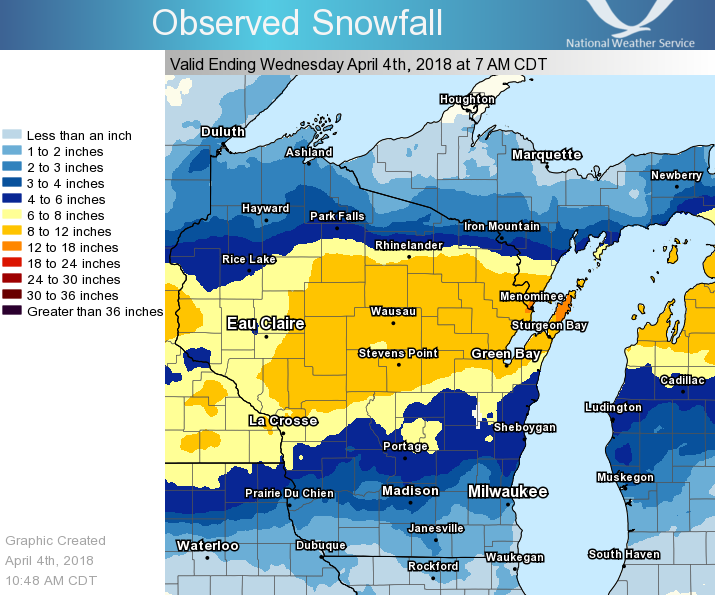
A late season winter storm brought a widespread 6 to 12 inch snowfall to central and northeast Wisconsin on April 3-4, 2018. Schools closed early as the snow picked up and winds increased during the day on the 3rd. The snow was a result of an area of low pressure that moved across northern Illinois. Daily snowfall records for April 3 were set at Sturgeon Bay, Wausau, Stevens Point, Green Bay, Wisconsin Rapids, Merrill, Marshfield, Appleton, and Oshkosh. In addition to the snow, strong north winds caused ice shoves to form on the shores of Green Bay. See the tabs below for more information. |
Snowfall / Wind Reports
...Snowfall Reports for April 3-4...

Location                     Amount    Time/Date       Provider

...Brown County...
Flintville                   11.6 in   0700 AM 04/04   COCORAHS
Suamico                      10.6 in   0700 AM 04/04   UCOOP
NWS Green Bay                9.4 in    0600 AM 04/04   COOP
Denmark WWTP                 6.2 in    0800 AM 04/04   COOP

...Calumet County...
Darboy 3 SE                  6.3 in    0700 AM 04/04   COCORAHS
Chilton                      6.0 in    0715 AM 04/04   COOP

...Door County...
Washington Island            12.7 in   0700 AM 04/04   COOP
Sturgeon Bay Exp Farm        12.0 in   0730 AM 04/04   COOP
Ephraim 5 SE - North Bay     9.5 in    0630 AM 04/04   UCOOP
Forestville 4 E              7.4 in    0800 AM 04/04   UCOOP

...Florence County...
Aurora                       6.5 in    0732 AM 04/04   UCOOP

...Forest County...
Crandon                      13.5 in   0600 AM 04/04   UCOOP

...Langlade County...
Summit Lake                  9.1 in    0645 AM 04/04   COOP

...Lincoln County...
Merrill 8 W                  9.2 in    0600 AM 04/04   UCOOP
Rice Reservoir No. 2         7.4 in    0700 AM 04/04   COOP

...Manitowoc County...
Two Rivers                   5.8 in    0715 AM 04/04   COOP

...Marathon County...
Wausau WSAW TV               11.1 in   1100 PM 04/03   COOP
Spencer                      10.9 in   0730 AM 04/04   UCOOP
Wausau-Northeast             8.9 in    0530 AM 04/04   UCOOP
Stratford 1 NW               7.5 in    0600 AM 04/04   COOP

...Marinette County...
Crivitz High Falls           12.0 in   0800 AM 04/04   COOP
Peshtigo                     11.0 in   0730 AM 04/04   COOP
Marinette                    11.0 in   0730 AM 04/04   COOP
Athelstane                   9.5 in    0600 AM 04/04   UCOOP
Wausaukee                    9.2 in    0800 AM 04/04   COOP

...Oneida County...
Rhinelander                  9.0 in    0730 AM 04/04   COOP
Rhinelander WJFW TV          8.1 in    1030 PM 04/03   COOP
Mc Naughton 3 SSE            7.9 in    0700 AM 04/04   COCORAHS
Lake Tomahawk 2 SE           4.7 in    0600 AM 04/04   UCOOP

...Outagamie County...
Appleton                     6.4 in    0700 AM 04/04   COOP

...Portage County...
Amherst 3 SE                 11.5 in   0700 AM 04/04   UCOOP
Plover                       10.9 in   0700 AM 04/04   UCOOP
Rosholt                      10.0 in   0706 AM 04/04   COOP
Amherst                      9.8 in    0600 AM 04/04   UCOOP
Plover 2 E                   9.0 in    0705 AM 04/04   UCOOP

...Shawano County...
Pella 3 SE                   12.5 in   0530 AM 04/04   UCOOP
Angelica                     10.7 in   0728 AM 04/04   COCORAHS
Stockbridge-Munsee Reservati 9.4 in    0845 AM 04/04   COOP
Shawano 2 SSW                8.7 in    0800 AM 04/04   COOP

...Waupaca County...
Big Falls 5 NW               11.7 in   0700 AM 04/04   UCOOP
Clintonville                 9.4 in    0700 AM 04/04   COOP
Waupaca                      8.5 in    0800 AM 04/04   COOP

...Waushara County...
Berlin                       7.2 in    0700 AM 04/04   COOP
Hancock Exp Farm             6.0 in    0800 AM 04/04   COOP
Wautoma Silver Lake Sanitary 5.3 in    0830 AM 04/04   COOP
Wild Rose                    5.1 in    0700 AM 04/04   COCORAHS

...Winnebago County...
Neenah                       6.6 in    0700 AM 04/04   COCORAHS
Omro 2 SW                    4.5 in    0700 AM 04/04   UCOOP
Oshkosh-North                4.4 in    0700 AM 04/04   UCOOP

...Wood County...
Wisconsin Rapids-Southeast   10.6 in   0630 AM 04/04   UCOOP
Marshfield Exp Farm          7.2 in    0730 AM 04/04   COOP

Observations are collected from a variety of sources with varying
equipment and exposures. We thank all volunteer weather observers
for their dedication. Not all data listed are considered official.
----------------------------------------------------------------------------------------------------------- ...Highest Wind Reports Past 48 Hours... Location Speed Time/Date Provider --------------------------------------------------------------- Green Bay Airport 44 MPH 0729 PM 04/03 ASOS Sister Bay 1 NNW 40 MPH 0257 AM 04/04 CWOP Oshkosh Airport 38 MPH 0832 PM 04/03 ASOS Combined Locks 1 W 38 MPH 0655 PM 04/03 CWOP Kewaunee 38 MPH 0806 PM 04/03 NWLON Sturgeon Bay Airport 38 MPH 1246 AM 04/04 AWOS Menominee 2 SE 37 MPH 0700 PM 04/03 NWLON Washington Island 1 WNW 37 MPH 1055 PM 04/03 MESOWEST 10 SE Clay Banks 34 MPH 0700 AM 04/04 MARITIME Manitowoc Airport 33 MPH 0237 AM 04/04 AWOS Plover 1 WSW 33 MPH 1022 PM 04/03 CWOP Appleton Airport 32 MPH 0945 PM 04/03 AWOS Antigo Airport 32 MPH 0215 AM 04/04 AWOS Mosinee Airport 31 MPH 0235 AM 04/04 AWOS Wrightstown 30 MPH 0844 PM 04/03 CWOP Omro 30 MPH 1146 PM 04/03 CWOP Shawano Airport 30 MPH 0835 PM 04/03 AWOS Clintonville Airport 30 MPH 0855 PM 04/03 AWOS Rhinelander Airport 30 MPH 0153 PM 04/04 ASOS Wayside 1 SW 29 MPH 0143 AM 04/04 CWOP Wisconsin Rapids Airport 29 MPH 0957 PM 04/03 ASOS Antigo 2 ENE 29 MPH 0905 PM 04/03 RAWS Butte Des Morts 2 WSW 28 MPH 0206 AM 04/04 CWOP Wautoma Airport 28 MPH 0110 PM 04/04 AWOS Howard 2 WNW 28 MPH 0714 PM 04/03 CWOP Moon 6 SW 27 MPH 1005 PM 04/03 RAWS Zittau 3 SSE 27 MPH 0217 PM 04/04 CWOP Breed 5 NE 27 MPH 1003 AM 04/04 RAWS Oconto Airport 26 MPH 0835 PM 04/03 AWOS Eagle River Airport 26 MPH 0215 PM 04/04 AWOS Appleton 2 ENE 26 MPH 0119 PM 04/04 CWOP Manitowish Waters Airport 26 MPH 1135 AM 04/04 AWOS Stevens Point Airport 26 MPH 0155 PM 04/04 AWOS Wausaukee 2 NW 25 MPH 1205 PM 04/04 RAWS Wabeno 2 NNW 25 MPH 0901 PM 04/03 RAWS Merrill Airport 25 MPH 0155 AM 04/04 AWOS Arbor Vitae Airport 25 MPH 0155 PM 04/04 AWOS Tomahawk Airport 25 MPH 0335 PM 04/04 AWOS Wausau Airport 25 MPH 1254 PM 04/04 ASOS Greenville 25 MPH 0447 PM 04/03 CWOP Coloma 4 W 25 MPH 0449 AM 04/04 CWOP Observations are collected from a variety of sources with varying equipment and exposures. We thank all volunteer weather observers for their dedication. Not all data listed are considered official. |
Click image for full view.
|
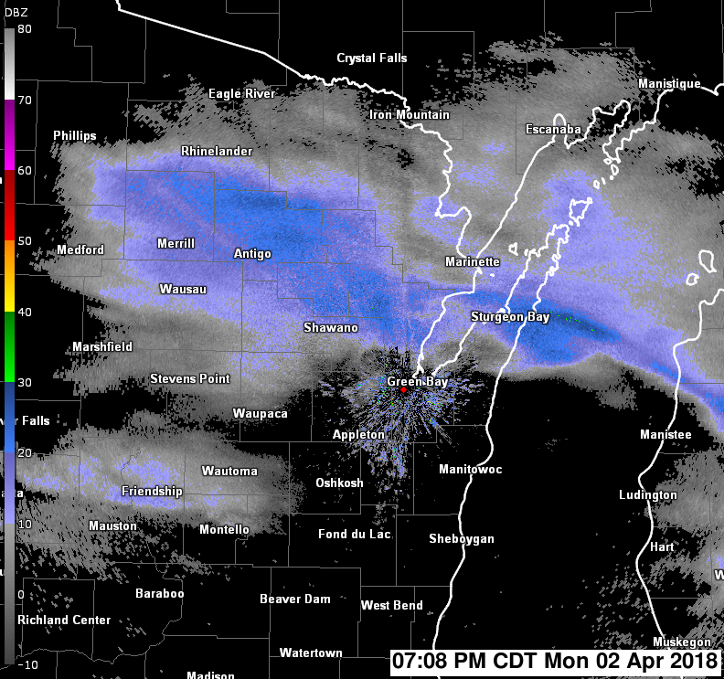
Radar:
Here is a look at the radar reflectivity animation from about 7 PM on Monday April 2 to just after midnight on Wednesday April 4.
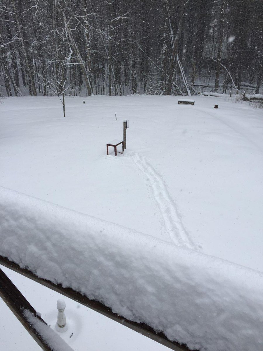
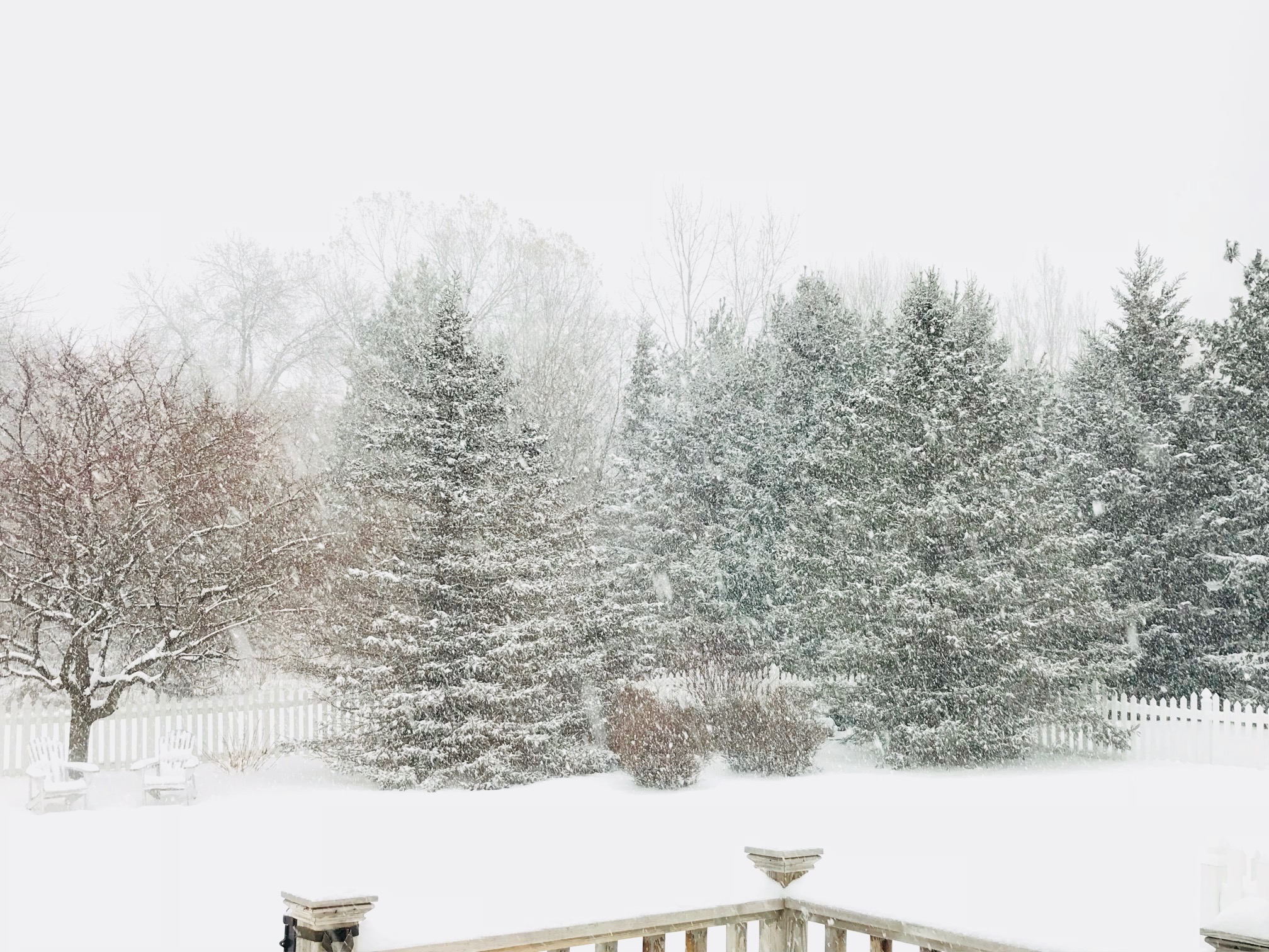
Pictures of the Storm:
 |
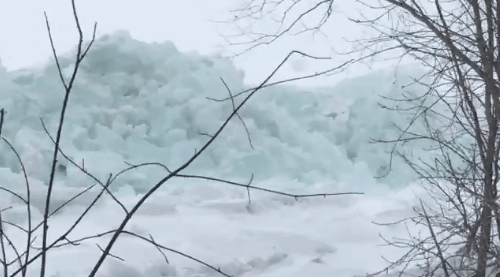 |
| Suamico, WI. Picture from Mickey Reimer. Click for full image. | Ice shove on Green Bay. Video by David Troup. |
 |
|
| Hobart, WI. Picture from Jeff Last. Click for full image. | |
 |
Media use of NWS Web News Stories is encouraged! Please acknowledge the NWS as the source of any news information accessed from this site. |
|