Record April Tornado Outbreak in Northeast Wisconsin on April 10, 2011
Last updated 5/18/11 10 am
An outbreak of severe thunderstorms and tornadoes tore across central and northeast Wisconsin during the evening of April 10, 2011. Fifteen tornadoes were confirmed in Wisconsin, most across the central and northeast part of the state.
 |
| Tornadoes on April 10, 2011. (Click for larger image.) |
Ten of the fifteen twisters touched down in the NWS Green Bay service area. The hardest hit areas included Waushara, Winnebago and southeast Outagamie counties in east-central Wisconsin, southern Lincoln County in north-central Wisconsin, and Forest County in the northeast part of the state. The ten tornadoes on April 10 is the largest tornado outbreak ever recorded in the NWS Green Bay service area. For Wisconsin, 15 tornadoes is a record April outbreak.
In addition to the tornadoes and large hail, several areas of damaging, straight-line winds were reported. Some of these "downburst" winds exceeded 80 mph, as strong as a tornado!
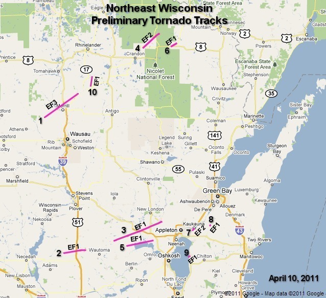
Tornado and Severe Weather Report Maps - Northeast Wisconsin Events Only
 |
|
| Northeast Wisconsin tornado track map. Track numbers correspond to "Preliminary Tornado Information" table below. (Click for larger image.) | |
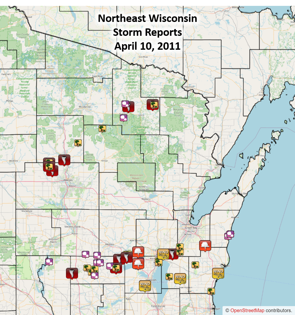
| Wind and Hail Damage | |
 |
|
| In addition to the tornadoes, damaging downburst winds and large hail were reported. (Click for larger image.) | |
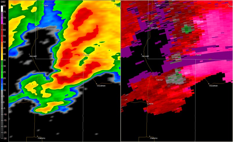
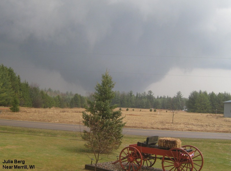
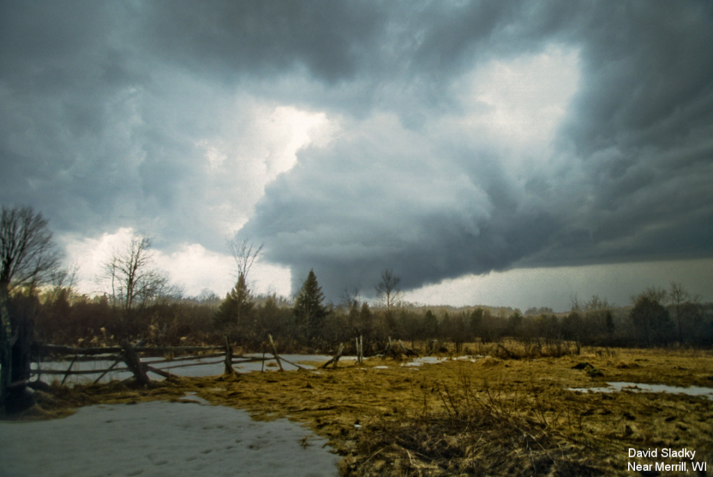
The strongest tornado occurred near Merrill, where a twister over a quarter mile wide caused considerable damage to homes, building, and trees on the north side of the city. Ten planes at the Merrill airport were damaged, three destroyed. The tornado was rated EF3 on the Enhanced Fujita (EF) tornado intensity scale.
 |
 |
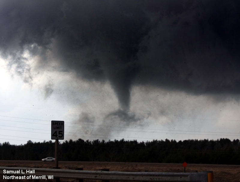 |
| Picture of the large tornado in Merrill near the time of peak intensity. (Click for larger view.) | Picture of the tornado near Merrill. (Click for larger view.) | Picture of the tornado moving away from Merrill. (Click for larger view.) |
Tornado Information - Northeast Wisconsin Tornadoes Only
(Thanks to county emergency management and the DNR for assistance with the surveys.)
| 1. Merrill - EF3 (Maximum winds 130-140 mph) | |
|
Time: 608 pm - 641 pm Area affected: Approximately 2 miles north of Hamburg (Marathon Co) to Merrill (Lincoln Co) to just west of Gleason (Lincoln Co) Path length: 21.2 miles Path width: 1050 yards (about 0.6 miles) Additional info: The worst damage (EF3) occurred a bit after 6:20 pm just north of the Merrill airport. At least 22 homes and 7 businesses were destroyed, and another 22 homes and 1 business sustained major damage. Damage was estimated at just over $11 million. |
|
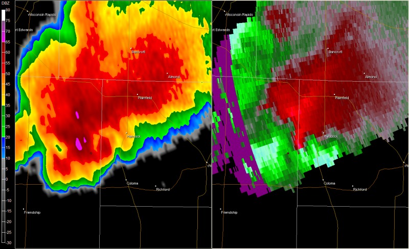
| 2. Adams County into Western Waushara County - EF1 (85 to 100 mph) | |
|
Time: 633 pm - 642 pm (entered Waushara Co approx 635 pm) Area affected: About 4 miles either side of Highway 39/51 south of Hancock Path length: 9.3 miles Path width: 140 yards Additional info: |
|
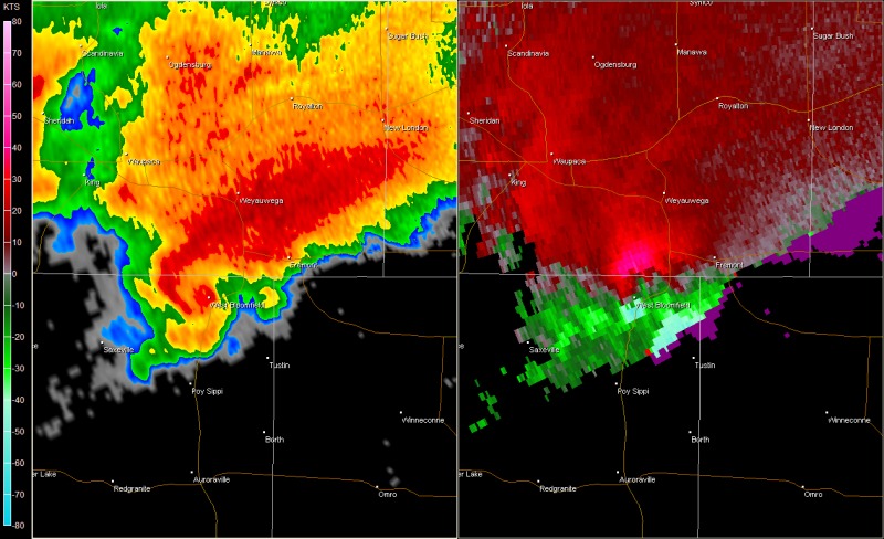
| 3. Fremont Area - EF1 (Maximum winds 90-100 mph) | |
|
Time: 706 pm - 743 pm Area affected: Saxeville (Waushara Co) to Fremont (Waupaca Co) to Hortonville (Outagamie Co.) Path length: 27.7 miles Path width: 200 yards Additional info: This tornado was not on the ground continuously, but damaged several farm buildings and snapped or uprooted thousands of trees. |
|
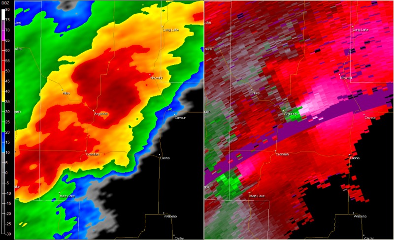
| 4. Central Forest County/Florence County - EF2 (Maximum winds 110-115 mph) | |
|
Time: 730 pm - 751 pm Area affected: 3 miles southeast of Argonne to about 6 miles southeast of Long Lake (Florence Co). Path length: 12.0 miles Path width: 600 yards Additional info: |
|
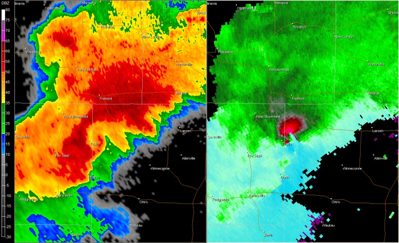
| 5. Lake Poygan Area - EF1 (Maximum winds 95-105 mph) | |
|
Time: 753 pm - 807 pm Area affected: Poy Sippi (Waushara Co) to west of Winchester near Highways MM and M (Winnebago Co) Path length: 14.9 miles Path width: 150 yards Additional info: 2 homes were destroyed and 12 homes and 2 businesses sustained major damage. Damage in this area was about $1.4 million. |
|
| 6. Eastern Forest County - EF1 (Maximum winds 95-105 mph) | |
|
Time: 803 pm - 808 pm Area affected: 4 miles west of Armstrong Creek to 1 mile northwest of Armstrong Creek Path length: 3.3 miles Path width: 250 yards Additional info: |
|
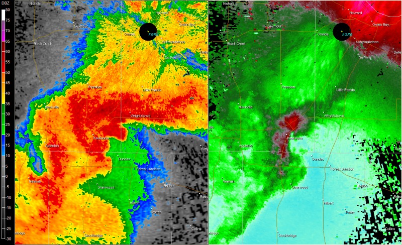
| 7. Kaukauna - EF2 (Maximum winds 110-120 mph) | |
| Time: 843 pm - 846 pm
Area affected: Southwest and central part of city of Kaukauna (Outagamie Co) Path length: 1.5 miles Path width: 175 yards Additional info: 24 homes and 4 businesses sustained major damage and 162 other homes received minor damage. Damage costs were $6.7 million. |
|
| 8. Greenleaf - EF1 (Maximum winds 85-95 mph) | |
| Time: 853 pm - 855 pm
Area affected: About 1 mile south of Greenleaf (Brown Co) Path length: 1.2 miles Path width: 75 yards Additional info: Aerial survey performed; confirmed previous ground survey. Silos damaged; barn roof ripped off. |
 |
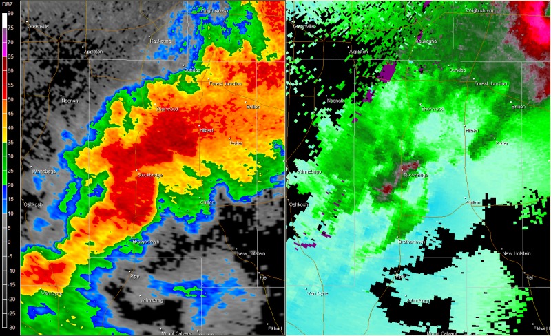
| 9. Stockbridge - EF1 (Maximum winds 85-90 mph) | |
| Time: 859 pm - 901 pm
Area affected: About 1 mile south of Stockbridge (Calumet Co) Path length: 1.7 miles Path width: 100 yards Additional info: Waterspout on Lake Winnebago was witnessed by residents on Twilight Beach Road. Storm moved onshore and caused mainly minor damage to four homes and ripped part of a roof off a large metal outbuilding. |
 |
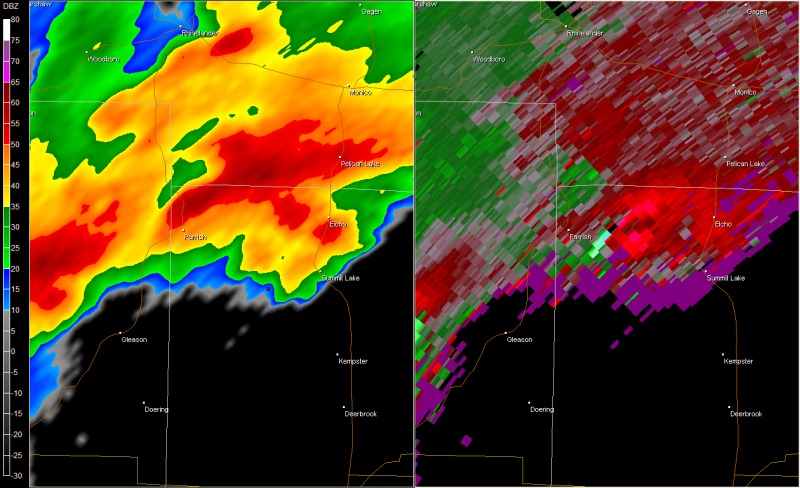
| 10. Langlade Co. - EF1 (Maximum winds near 110 mph) | |
| Time: 650 pm - 658 pm
Area affected: South and east of Parrish Path length: 5.3 miles Path width: 400 yards Additional info: Tornado confirmed after analysis of fly-over results by DNR and Langlade County Forestry. Tornado witnessed by storm chaser at 655 pm. Approximately a million trees were snapped, uprooted, or damaged in a 1600 acre area. |
 |
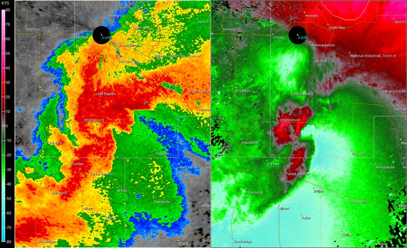
Satellite and Radar Images - Storm Evolution
 |
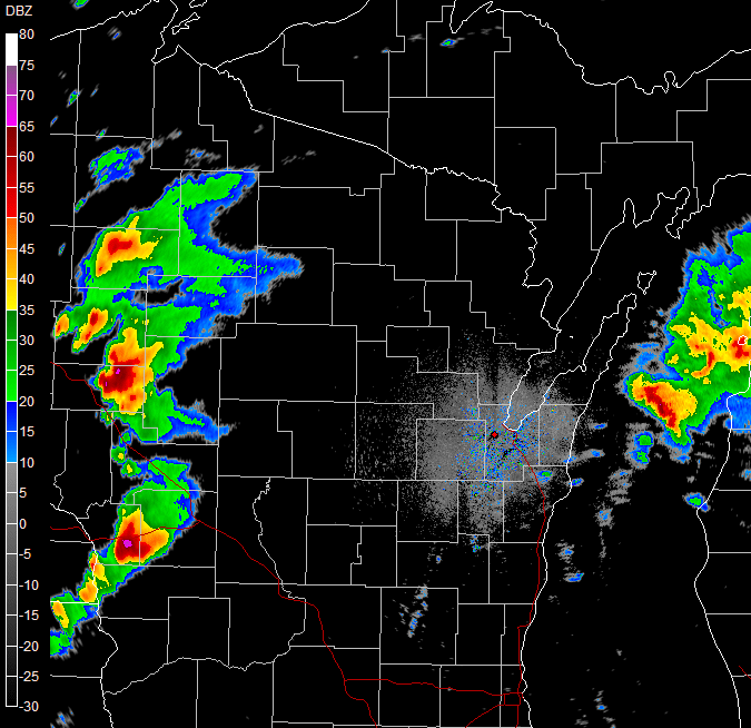 |
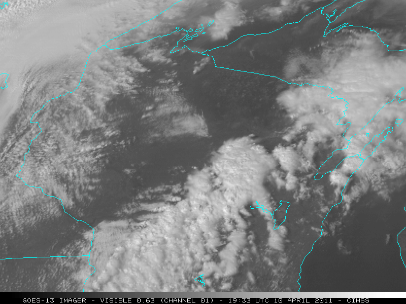
| Satellite animation from about 3 pm to 7 pm. Imagery courtesy UW-SSEC-CIMSS. (May take a moment to load. Click for larger view.) | Reflectivity animation (0.5 deg KGRB) from 5 pm to 930 pm. (Click for larger view.) |