Overview
|
A line of showers and isolated thunderstorms moved into central Wisconsin Friday night into Saturday along a slow-moving cold front. An initial 1 to 3 inches of rain fell Friday night, followed by another 1 to 2 inches on Saturday. As the cold front reached eastern Wisconsin Saturday afternoon, thunderstorms intensified with 3 tornadoes touching down over Winnebago County. One of these tornadoes was over Lake Butte des Morts and another was over Lake Winnebago.
Please click on the tabs below for more information. |
.gif) |
Tornado Reports:
Map of received tornado reports:
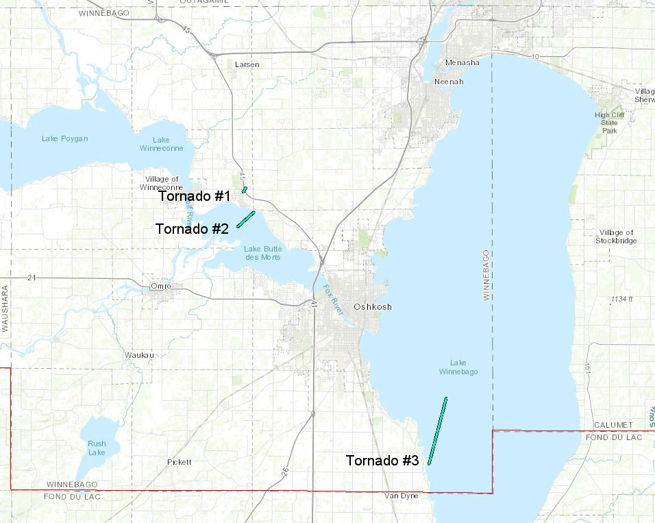
PUBLIC INFORMATION STATEMENT
NATIONAL WEATHER SERVICE GREEN BAY WI
1111 AM CDT FRI JUN 26 2020

...NWS DAMAGE SURVEY FOR 06/20/2020 TORNADO EVENT...

.TORNADO # 1 WINNEBAGO COUNTY...

RATING:                 EF-0
ESTIMATED PEAK WIND:    65 MPH
PATH LENGTH /STATUTE/:  0.25 MILES
PATH WIDTH /MAXIMUM/:   50 YARDS
FATALITIES:             0
INJURIES:               0

START DATE:             06/20/2020
START TIME:             5:01 PM CDT
START LAT/LON:          44.1097 / -88.6528

END DATE:               06/20/2020
END TIME:               5:02 PM CDT
END LAT/LON:            44.1128 / -88.6503

A BRIEF TORNADO TOUCHDOWN WAS WITNESSED BY THE OSHKOSH FIRE
DEPARTMENT NEAR HIGHWAY 45 NEAR BUTTE DES MORTS. NO DAMAGE WAS
REPORTED.

.TORNADO # 2 WINNEBAGO COUNTY...

RATING:                 EF-0
ESTIMATED PEAK WIND:    65 MPH
PATH LENGTH /STATUTE/:  1.07 MILES
PATH WIDTH /MAXIMUM/:   75 YARDS
FATALITIES:             0
INJURIES:               0

START DATE:             06/20/2020
START TIME:             5:23 PM CDT
START LAT/LON:          44.0848 / -88.6582

END DATE:               06/20/2020
END TIME:               5:27 PM CDT
END LAT/LON:            44.0952 / -88.6422

A STORM CHASER AND THE PUBLIC SPOTTED A TORNADO OVER LAKE BUTTE
DES MORTS NEAR COUNTY S. THE TORNADO DISSIPATED BEFORE REACHING
SHORE.

.TORNADO # 3 WINNEBAGO COUNTY...

RATING:                 EF-0
ESTIMATED PEAK WIND:    65 MPH
PATH LENGTH /STATUTE/:  3.37 MILES
PATH WIDTH /MAXIMUM/:   75 YARDS
FATALITIES:             0
INJURIES:               0

START DATE:             06/20/2020
START TIME:             5:35 PM CDT
START LAT/LON:          43.9139 / -88.4666

END DATE:               06/20/2020
END TIME:               5:41 PM CDT
END LAT/LON:            43.9611 / -88.4494

MULTIPLE EYEWITNESS REPORTS OF A TORNADO OVER LAKE WINNEBAGO 5 TO
6 MILES SOUTHEAST OF OSHKOSH WITTMAN FIELD AIRPORT. THE TORNADO
DISSIPATED BEFORE REACHING SHORE.

EF SCALE: THE ENHANCED FUJITA SCALE CLASSIFIES
TORNADOES INTO THE FOLLOWING CATEGORIES.

EF0...WEAK......65 TO 85 MPH
EF1...WEAK......86 TO 110 MPH
EF2...STRONG....111 TO 135 MPH
EF3...STRONG....136 TO 165 MPH
EF4...VIOLENT...166 TO 200 MPH
EF5...VIOLENT...>200 MPH

NOTE:

THE INFORMATION IN THIS STATEMENT IS PRELIMINARY AND SUBJECT TO
CHANGE PENDING FINAL REVIEW OF THE EVENTS AND PUBLICATION IN
NWS STORM DATA.

$$
Radar:
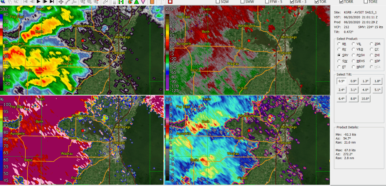 |
Upper left: Base reflectivity Upper right: Storm relative motion Lower left: Correlation coefficient (CC) Lower right: Specific differential phase (KDP) |
.gif) |
Radar loop 4:00 - 8:50 PM June 20 |
Rain:
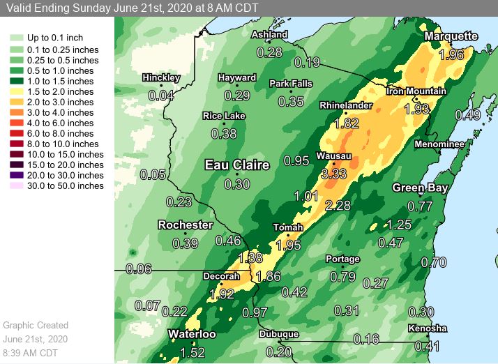 |
2-Day rainfall totals ending around 9 am June 21 | ||
PUBLIC INFORMATION STATEMENT
NATIONAL WEATHER SERVICE GREEN BAY WI
1019 AM CDT SUN JUN 21 2020

...PRECIPITATION REPORTS...

LOCATION                     AMOUNT    TIME/DATE
EVERGREEN 1 E                4.24 IN   0700 AM 06/21
WAUSAU                       4.00 IN   1002 AM 06/21
STEVENS POINT                3.84 IN   0730 AM 06/21
EVERGREEN 1.5 WSW            3.79 IN   0640 AM 06/21
MOSINEE                      3.78 IN   1000 AM 06/21
MOUNTAIN                     3.75 IN   1004 AM 06/21
WISCONSIN RAPIDS             3.73 IN   0700 AM 06/21
ANTIGO 1 SSW                 3.59 IN   0800 AM 06/21
WAUSAU 1 ENE                 3.45 IN   0600 AM 06/21
WAUSAU AIRPORT               3.41 IN   0954 AM 06/21
ANTIGO 2 ENE                 3.36 IN   0605 AM 06/21
KNOWLTON                     3.27 IN   1000 AM 06/21
ANTIGO AIRPORT               3.02 IN   0955 AM 06/21
WAUSAU 1 SSE                 2.96 IN   1005 AM 06/21
WHITE LAKE 1.4 SE            2.92 IN   0800 AM 06/21
RUDOLPH 1 NNE                2.82 IN   0500 AM 06/21
TOWNSEND 1.7 NNW             2.79 IN   0600 AM 06/21
ATHELSTANE 6 SW              2.73 IN   0700 AM 06/21
WAUSAU 2.2 NE                2.72 IN   0630 AM 06/21
WAUSAU                       2.69 IN   0700 AM 06/21
WISCONSIN RAPIDS AIRPORT     2.67 IN   0954 AM 06/21
SUMMIT LAKE                  2.62 IN   0500 AM 06/21
LAKEWOOD                     2.46 IN   1001 AM 06/21
WABENO 2 NNW                 2.33 IN   1001 AM 06/21
WAUSAU 5.4 SSW               2.25 IN   0700 AM 06/21
WISCONSIN RAPIDS             2.21 IN   1000 AM 06/21
WABENO 2 NNW                 2.12 IN   1004 AM 06/21
PORT EDWARDS 2 WNW           2.00 IN   1000 AM 06/21
SPREAD EAGLE 1 NW            2.00 IN   0700 AM 06/21
WISCONSIN RAPIDS 1 ESE       1.99 IN   1005 AM 06/21
KELLNER 3 WNW                1.98 IN   0630 AM 06/21
NEW LONDON 2 SE              1.94 IN   0630 AM 06/21
ATHELSTANE 1.6 E             1.91 IN   0600 AM 06/21
NEW LONDON - WWTP            1.88 IN   0700 AM 06/21
MOON 6 SW                    1.88 IN   0605 AM 06/21
ROYALTON                     1.86 IN   0700 AM 06/21
BREED 5 NE                   1.75 IN   1003 AM 06/21
ATHELSTANE 2 SW              1.75 IN   1000 AM 06/21
OGDENSBURG 2 E               1.75 IN   0700 AM 06/21
VESPER                       1.73 IN   1002 AM 06/21
CRANDON                      1.73 IN   0955 AM 06/21
STEVENS POINT AIRPORT        1.66 IN   0955 AM 06/21
NEENAH 1.1 ENE               1.60 IN   0700 AM 06/21
QUINNESEC 1 S                1.56 IN   1004 AM 06/21
PORT EDWARDS 2 E             1.56 IN   0645 AM 06/21
MACKVILLE 2 S                1.53 IN   0600 AM 06/21
WAUPACA 1 E                  1.50 IN   0700 AM 06/21
KAUKAUNA                     1.48 IN   1000 AM 06/21
NEW LONDON 4.1 N             1.47 IN   0600 AM 06/21
APPLETON                     1.46 IN   0600 AM 06/21
ARGONNE 1.5 NW               1.42 IN   0704 AM 06/21
APPLETON                     1.39 IN   1005 AM 06/21
DARBOY 3 SE                  1.35 IN   0700 AM 06/21
LARSEN 4 ENE                 1.34 IN   1004 AM 06/21
1.0 NE NEW LONDON            1.33 IN   0900 AM 06/21
ZITTAU                       1.33 IN   0600 AM 06/21
MENASHA 2.4 E                1.32 IN   0700 AM 06/21
ROSHOLT                      1.31 IN   0740 AM 06/21
APPLETON                     1.30 IN   1004 AM 06/21
BOWLER 1 WNW                 1.28 IN   1004 AM 06/21
KAUKAUNA                     1.28 IN   1000 AM 06/21
PELLA 3 SE                   1.28 IN   0530 AM 06/21
WAUPACA                      1.26 IN   0955 AM 06/21
WRIGHTSTOWN                  1.25 IN   1001 AM 06/21
AMBERG 9 E                   1.25 IN   0614 AM 06/21
BRILLION 2 SSE               1.17 IN   0800 AM 06/21
WRIGHTSTOWN 0.4 ENE          1.17 IN   0700 AM 06/21
KESHENA 2 WNW                1.17 IN   0605 AM 06/21
NEW ROME 4 ENE               1.15 IN   0605 AM 06/21
WRIGHTSTOWN 4 NNE            1.15 IN   0600 AM 06/21
WAUPACA 5.7 WSW              1.14 IN   0730 AM 06/21
REEDSVILLE                   1.13 IN   1001 AM 06/21
OMRO                         1.10 IN   1001 AM 06/21
WINNEBAGO 3 NW               1.08 IN   0700 AM 06/21
APPLETON                     1.01 IN   0607 AM 06/21
NEW LONDON 1 SW              0.96 IN   1005 AM 06/21
PLOVER 2 E                   0.96 IN   0700 AM 06/21
MERRILL AIRPORT              0.94 IN   0955 AM 06/21
ALMOND 5 NE                  0.94 IN   0800 AM 06/21
GREENVILLE                   0.93 IN   1002 AM 06/21
WAUPACA                      0.93 IN   1000 AM 06/21
PLOVER                       0.93 IN   0957 AM 06/21
KESHENA 4 NE                 0.92 IN   1005 AM 06/21
DENMARK WWTP                 0.92 IN   0800 AM 06/21
MERRILL 8 W                  0.92 IN   0600 AM 06/21
BLACK CREEK 3 NW             0.91 IN   0700 AM 06/21
WAUSAUKEE 2 NW               0.90 IN   0605 AM 06/21
OMRO                         0.87 IN   1001 AM 06/21
DE PERE                      0.87 IN   1000 AM 06/21
RHINELANDER 2 SW             0.87 IN   0730 AM 06/21
RHINELANDER 5 N              0.84 IN   0800 AM 06/21
DE PERE                      0.81 IN   1001 AM 06/21
GREEN BAY AIRPORT            0.80 IN   0953 AM 06/21
CHAMPION 1 NNW               0.78 IN   0730 AM 06/21
GREEN BAY                    0.78 IN   0600 AM 06/21
CLINTONVILLE AIRPORT         0.75 IN   0955 AM 06/21
OMRO 1 WSW                   0.72 IN   0700 AM 06/21
ASHWAUBENON 2 NNE            0.71 IN   1005 AM 06/21
SEYMOUR                      0.71 IN   0955 AM 06/21
MARSHFIELD 1.0 WNW           0.70 IN   0700 AM 06/21
WINCHESTER                   0.69 IN   1003 AM 06/21
MOON 1 E                     0.69 IN   0700 AM 06/21
ALLOUEZ                      0.68 IN   1002 AM 06/21
STILES 1 S                   0.68 IN   0730 AM 06/21
CRIVITZ 1 ESE                0.65 IN   1005 AM 06/21
ST. NAZIANZ 2 W              0.65 IN   0700 AM 06/21
CHILTON 0.5 E                0.65 IN   0700 AM 06/21
EAGLE RIVER - SOUTH          0.64 IN   0659 AM 06/21
GREEN BAY                    0.62 IN   1001 AM 06/21
RHINELANDER 4 NE             0.60 IN   0600 AM 06/21
PULASKI 3.7 W                0.57 IN   0700 AM 06/21
BERLIN WWTP                  0.56 IN   0700 AM 06/21
MANITOWOC                    0.53 IN   1002 AM 06/21
MC NAUGHTON 3 SSE            0.53 IN   0700 AM 06/21
AMHERST 3 SE                 0.53 IN   0700 AM 06/21
PHELPS 2 SW                  0.51 IN   1002 AM 06/21
RHINELANDER AIRPORT          0.51 IN   0953 AM 06/21
SHAWANO 2 SSW                0.51 IN   0800 AM 06/21
WAUTOMA AIRPORT              0.50 IN   0956 AM 06/21
VALDERS 3.3 WSW              0.50 IN   0700 AM 06/21

OBSERVATIONS ARE COLLECTED FROM A VARIETY OF SOURCES WITH VARYING
EQUIPMENT AND EXPOSURES. WE THANK ALL VOLUNTEER WEATHER OBSERVERS
FOR THEIR DEDICATION. NOT ALL DATA LISTED ARE CONSIDERED OFFICIAL
|
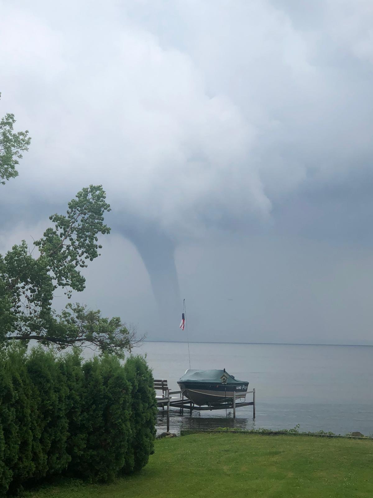
Pictures
 |
.jpg) |
 |
|
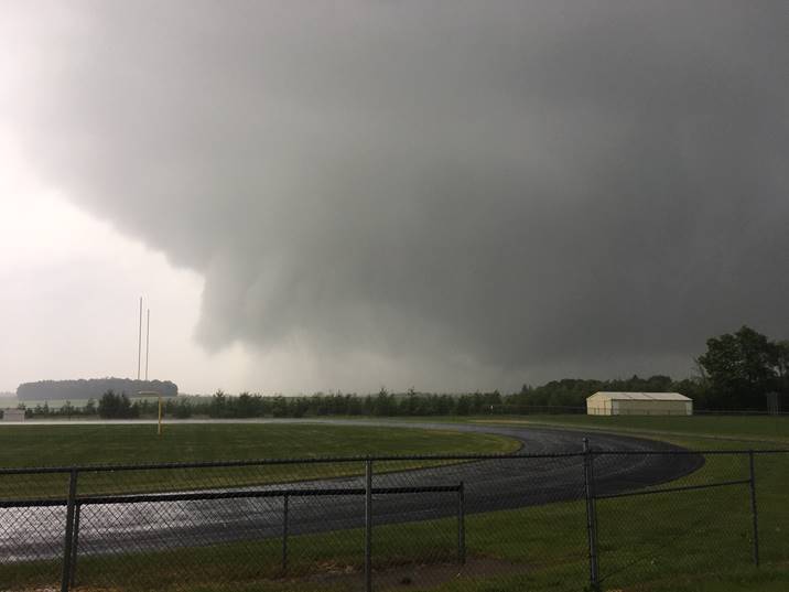
Lake Winnebago southeast of Oshkosh Photo courtesy of @bbass_34 |
Lake Winnebago Photo courtesy of James Hall Jr |
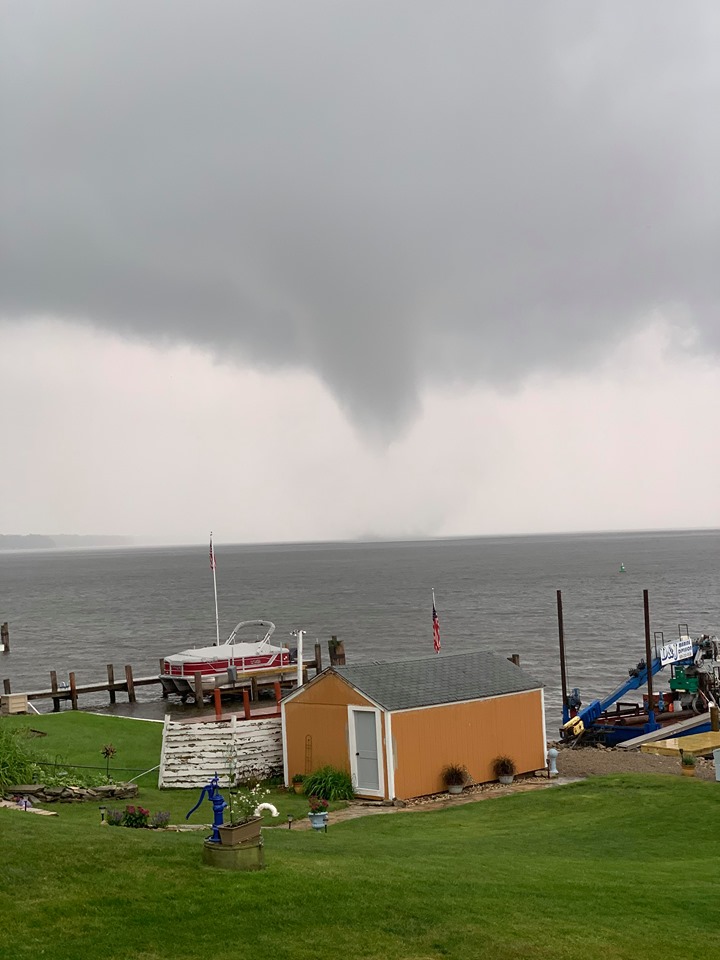
Tornado over Lake Butte des Morts Photo courtesy of Janet Elliott |
 |
 |
 |
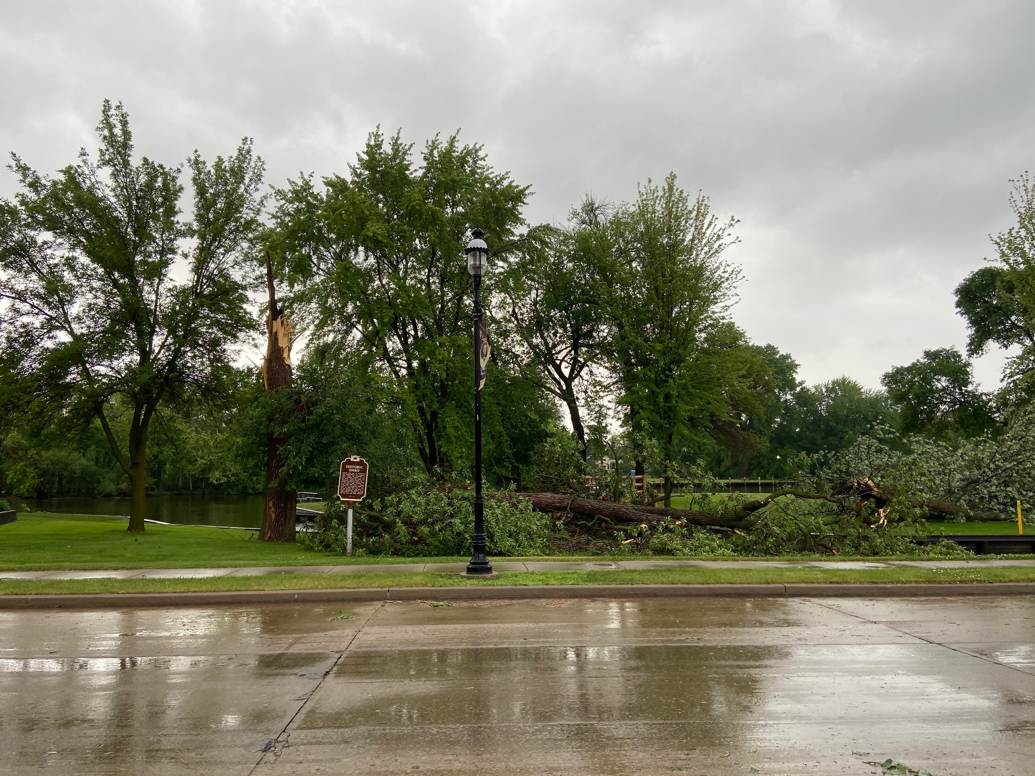
| Omro -- Photos courtesy of Cory Anderson | ||
|
Tornado over Lake Butte des Morts, WI Photo courtesy of Hunter Bolssen |
|
 |
Media use of NWS Web News Stories is encouraged! Please acknowledge the NWS as the source of any news information accessed from this site. |
|


