Overview
|
Scattered thunderstorms, some severe, developed ahead of a cold front that moved into a very warm and humid air mass across central and northeast Wisconsin. The strongest storms produced "wet microbursts" that resulted in winds over 75 mph and large hail. Many dozens of trees were uprooted or snapped across the hardest hit areas. Six buildings sustained at least minor damage from fallen trees in the Mountain area of Oconto County. Rainfall rates of over 2 inches per hour were reported with the strongest storms. |
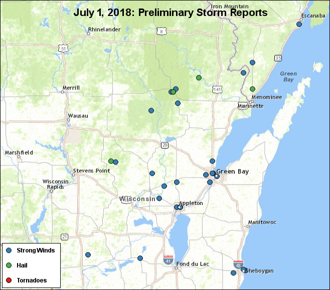 Preliminary Storm Report Map |
Photos:
 |
 |
 |
 |
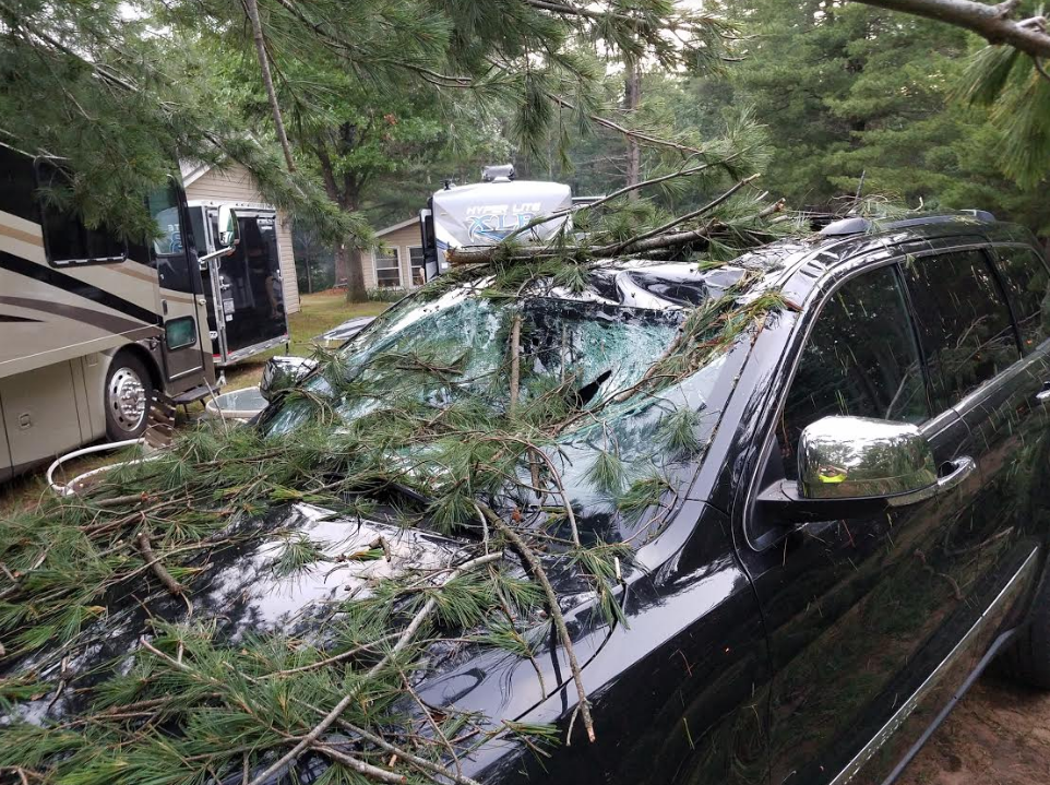
| Damage near Crooked Lake, Oconto County (Brett Shauger) |
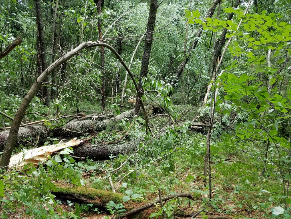
East of Neopit, Menominee County (Shelley Williams) |
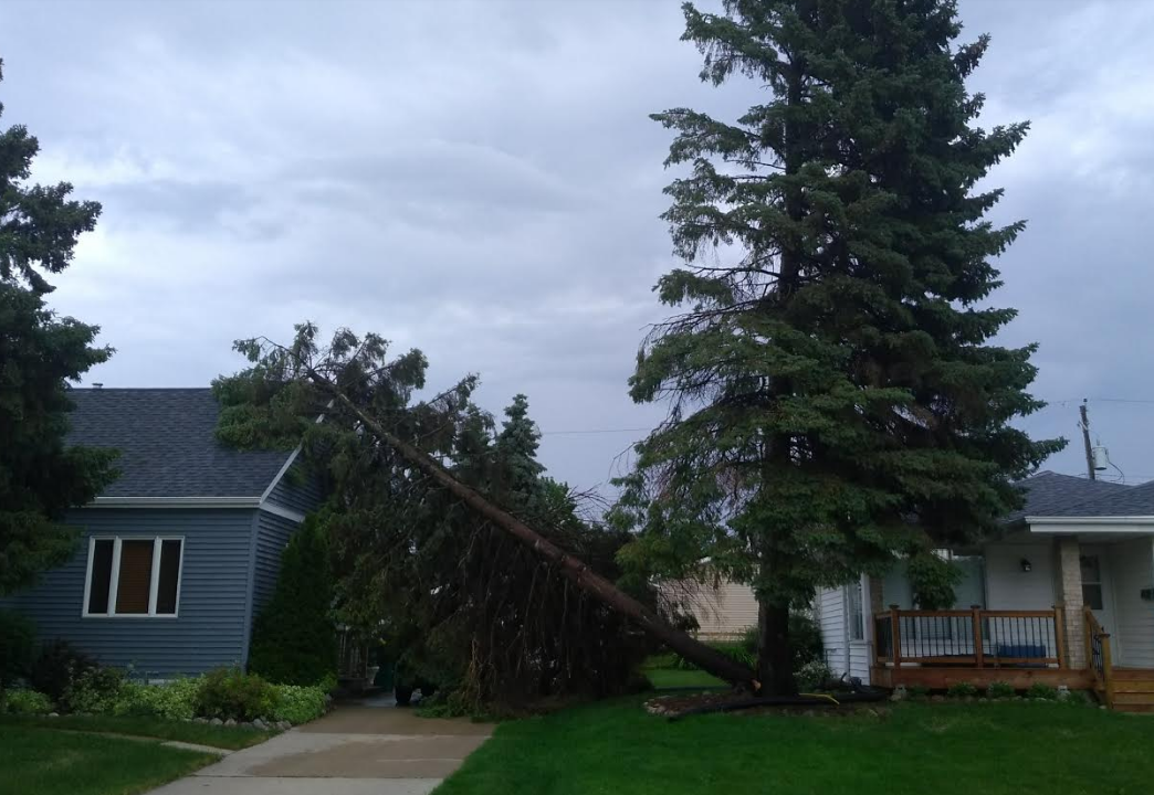
Green Bay, Brown County (Andrew Becker) |
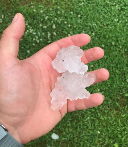
Hail in NW Waupaca County (Jordan Richter) |
Radar:
 |
 |
||
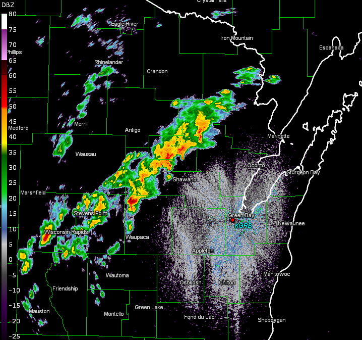
| Radar image at 12:15 PM showing developing severe storms. | Radar animation during July 1 afternoon. |
Storm Reports - Preliminary
..TIME...   ...EVENT...      ...CITY LOCATION...     ...LAT.LON...
..DATE...   ....MAG....      ..COUNTY LOCATION..ST.. ...SOURCE....
            ..REMARKS..

1220 PM     TSTM WND DMG     8 N IOLA                44.62N 89.11W
07/01/2018                   WAUPACA            WI   LAW ENFORCEMENT

            FEW TREES DOWN. TIME ESTIMATED BY RADAR.

1225 PM     TSTM WND DMG     7 ENE NEOPIT            45.00N 88.66W
07/01/2018                   MENOMINEE          WI   EMERGENCY MNGR

            DAMAGE IN THE AREA OF DELLS CREEK RD. TIME ESTIMATED BY
            RADAR.

1225 PM     TSTM WND DMG     2 NE MOUNTAIN           45.20N 88.45W
07/01/2018                   OCONTO             WI   PUBLIC

            MANY TREES SNAPPED AND UPROOTED NEAR CROOKED LAKE. VIA
            SOCIAL MEDIA.

1230 PM     HAIL             3 NW SCHMIDT CORNER     44.63N 89.16W
07/01/2018  E1.75 INCH       WAUPACA            WI   PUBLIC

            RELAYED BY WAOW.

1245 PM     HAIL             MOUNTAIN                45.18N 88.48W
07/01/2018  M1.00 INCH       OCONTO             WI   PUBLIC

1246 PM     TSTM WND DMG     1 W MOUNTAIN            45.18N 88.50W
07/01/2018                   OCONTO             WI   TRAINED SPOTTER

            ON COUNTY ROAD W...OVER 50 TREES SNAPPED AND UPROOTED.
            POWER OFF IN CITY.

1247 PM     TSTM WND DMG     MOUNTAIN                45.18N 88.48W
07/01/2018                   OCONTO             WI   TRAINED SPOTTER

            REPORTS OF MULTIPLE TREES DOWN IN MOUNTAIN.

1248 PM     TSTM WND DMG     2 N BREED               45.09N 88.43W
07/01/2018                   OCONTO             WI   TRAINED SPOTTER

            REPORT OF MULTIPLE TREES SNAPPED.

1250 PM     HAIL             SE MOUNTAIN             45.18N 88.48W
07/01/2018  M1.00 INCH       OCONTO             WI   PUBLIC

0115 PM     HAIL             HIGH FALLS RESERVOIR    45.29N 88.20W
07/01/2018  M1.00 INCH       MARINETTE          WI   PUBLIC

0150 PM     TSTM WND DMG     MCALLISTER              45.33N 87.71W
07/01/2018                   MARINETTE          WI   AMATEUR RADIO

            NEAR HWY 141 AND COUNTY ROAD JJ. MULTIPLE TREES DOWN.

0216 PM     HEAVY RAIN       MOUNTAIN                45.18N 88.48W
07/01/2018  M2.15 INCH       OCONTO             WI   TRAINED SPOTTER

            FROM 1230 TO 130 PM.

0236 PM     TSTM WND DMG     2 W APPLETON            44.26N 88.44W
07/01/2018                   OUTAGAMIE          WI   LAW ENFORCEMENT

            TREES DOWN.

0237 PM     TSTM WND DMG     APPLETON                44.26N 88.40W
07/01/2018                   OUTAGAMIE          WI   AMATEUR RADIO

             MANY TREE LIMBS DOWN. NEAR 300 BLOCK OF SOUTH BUCHANAN.

0237 PM     TSTM WND DMG     NW APPLETON             44.26N 88.40W
07/01/2018                   OUTAGAMIE          WI   PUBLIC

            LARGE TREE UPROOTED. VIA SOCIAL MEDIA. IN THE GRAND CHUTE
            AREA.

0238 PM     TSTM WND GST     APPLETON                44.26N 88.40W
07/01/2018  M49.00 MPH       OUTAGAMIE          WI   AWOS

0238 PM     TSTM WND DMG     SHIOCTON                44.43N 88.58W
07/01/2018                   OUTAGAMIE          WI   TRAINED SPOTTER

            MANY TREES SNAPPED AND UPROOTED. POWER OUT IN CITY. WIND
            GUST TO 55 MPH.

0240 PM     TSTM WND DMG     BLACK CREEK             44.46N 88.44W
07/01/2018                   OUTAGAMIE          WI   PUBLIC

            TREES UPROOTED IN CITY.

0242 PM     TSTM WND DMG     W APPLETON              44.26N 88.40W
07/01/2018                   OUTAGAMIE          WI   AMATEUR RADIO

            NEAR HWY 96 AND COUNTY ROAD T. A FEW BRANCHES DOWN. POWER
            OUT.

0300 PM     TSTM WND GST     ASHWAUBENON             44.46N 88.08W
07/01/2018  M52.00 MPH       BROWN              WI   ASOS

0304 PM     TSTM WND DMG     3 WNW GREEN BAY         44.53N 88.05W
07/01/2018                   BROWN              WI   TRAINED SPOTTER

            TREE DOWN ON MATHER AND PLATTEN ST.

0311 PM     TSTM WND GST     4 SW HOWARD             44.52N 88.12W
07/01/2018  M60.00 MPH       BROWN              WI   TRAINED SPOTTER

0313 PM     TSTM WND DMG     HORTONVILLE             44.33N 88.63W
07/01/2018                   OUTAGAMIE          WI   AMATEUR RADIO

            16 INCH LIMB SNAPPED. NEAR SCHOOL ROAD.

0315 PM     TSTM WND DMG     SUAMICO                 44.63N 88.05W
07/01/2018                   BROWN              WI   AMATEUR RADIO

            6 INCH LIMB SNAPPED. NEAR COUNTY ROAD M.

0315 PM     TSTM WND DMG     NE GREEN BAY            44.51N 88.00W
07/01/2018                   BROWN              WI   AMATEUR RADIO

            WIND GUST OVER 50 MPH AND 3 INCH BRANCHES SNAPPED. NEAR
            HUMBOLDT AND I43.
 |
Media use of NWS Web News Stories is encouraged! Please acknowledge the NWS as the source of any news information accessed from this site. |
|

