Overview
|
A line of severe thunderstorms produced strong winds and hail across central and northeast Wisconsin during the morning of July 21, 2016. The squall line developed early in the morning in a warm and very humid air mass. Storms produced widespread wind gusts over 55 mph and some hail. Trees and power lines were knocked down at many locations. The line of storms quickly moved southeast across the area, traversing the northeast third of Wisconsin in about four hours (Vilas County to Manitowoc County). |
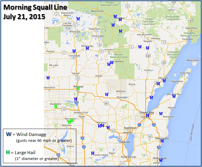 July 21, 2016 Morning Storm Reports |
Wind & Hail:
The storms produced widespread high winds, but a few hail reports were also received in central Wisconsin.
Storm Map
|
|||
| Reports |
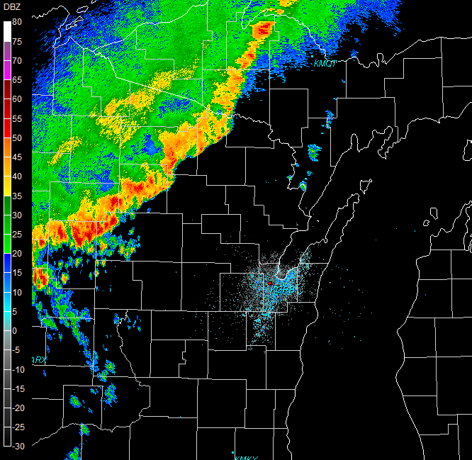
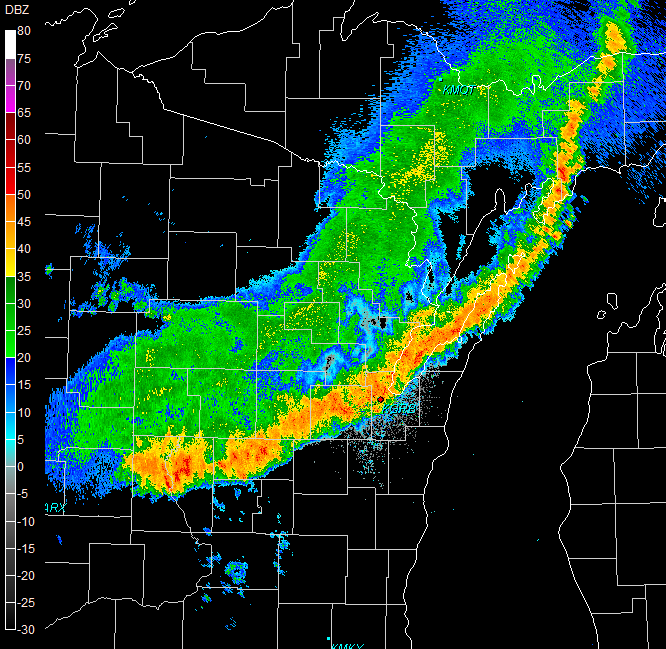
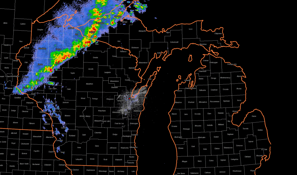
Radar:
Radar showed a classic squall line as storms organized in a linear fashion and quickly moved southeast across the region.
 |
 |
 |
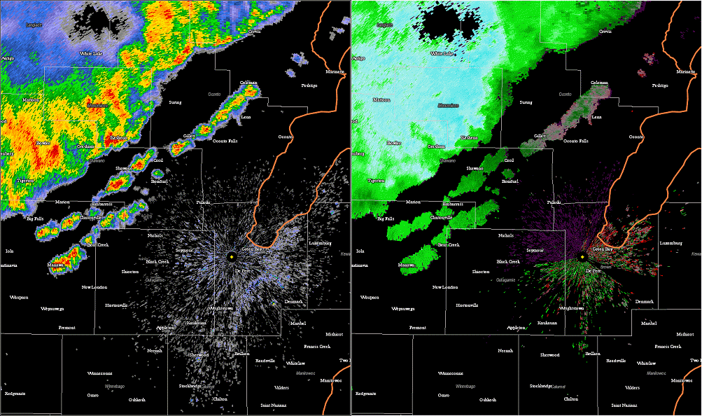 |
| 6:30 AM Radar | 8:30 AM Radar | Overview Animation | Reflectivity & Velocity |
Storm Reports
..TIME...   ...EVENT...      ...CITY LOCATION...     ...LAT.LON...
..DATE...   ....MAG....      ..COUNTY LOCATION..ST.. ...SOURCE....
            ..REMARKS..

0545 AM     TSTM WND DMG     BOULDER JUNCTION        46.11N 89.63W
07/21/2016                   VILAS              WI   LAW ENFORCEMENT

            NUMEROUS TREES AND POWERLINES DOWN THROUGHOUT MUCH OF THE
            COUNTY. SOME TREES DOWN ON HOUSES. WIND DAMAGE OCCURRED
            FROM APPROXIMATELY 515 AM TO 615 AM CDT BASED ON RADAR.

0612 AM     TSTM WND DMG     TOMAHAWK                45.46N 89.73W
07/21/2016                   LINCOLN            WI   LAW ENFORCEMENT

            TREES DOWN. TIME ESTIMATED.

0620 AM     TSTM WND DMG     ALVIN                   46.01N 88.81W
07/21/2016                   FOREST             WI   LAW ENFORCEMENT

            A FEW POWER LINES DOWN IN THE ALVIN AREA. TIME ESTIMATED
            FROM RADAR.

0625 AM     TSTM WND DMG     RHINELANDER             45.63N 89.41W
07/21/2016                   ONEIDA             WI   LAW ENFORCEMENT

            TREES DOWN. TIME ESTIMATED.

0635 AM     TSTM WND DMG     TIPLER                  45.91N 88.63W
07/21/2016                   FLORENCE           WI   LAW ENFORCEMENT

            NUMEROUS TREES DOWN ON POWERLINES MAINLY IN THE WESTERN
            PORTION OF THE COUNTY IN THE TIPLER...LONG LAKE AND FERN
            AREAS. TIME ESTIMATED VIA RADAR.

0645 AM     TSTM WND DMG     SUMMIT LAKE             45.38N 89.19W
07/21/2016                   LANGLADE           WI   LAW ENFORCEMENT

            NUMEROUS TREES AND POWERLINES DOWN.

0655 AM     TSTM WND DMG     PEARSON                 45.36N 89.01W
07/21/2016                   LANGLADE           WI   LAW ENFORCEMENT

            NUMEROUS TREES AND POWERLINES DOWN IN THE PEARSON AREA
            EASTWARD TO HIGHWAY 55 NEAR PICKEREL. POWER OUTAGES IN
            THIS AREA AS WELL. TIME ESTIMATED VIA RADAR.

0700 AM     TSTM WND DMG     PICKEREL                45.36N 88.91W
07/21/2016                   LANGLADE           WI   LAW ENFORCEMENT

            NUMEROUS TREES AND POWERLINES DOWN IN THE PICKEREL AREA
            EASTWARD TO HIGHWAY 52. POWER OUTAGES ALSO REPORTED IN
            THIS AREA. TIME ESTIMATED VIA RADAR.

0703 AM     TSTM WND DMG     10 W CARTER             45.39N 88.84W
07/21/2016                   FOREST             WI   LAW ENFORCEMENT

            NUMEROUS TREES AND POWERLINES DOWN IN THE FAR SOUTHERN
            AND SOUTHWESTERN PORTION OF THE COUNTY WEST OF
            CARTER...AND ABOUT 2 MILES NORTH OF THE PICKEREL AREA.

0705 AM     TSTM WND DMG     DUNBAR                  45.65N 88.18W
07/21/2016                   MARINETTE          WI   LAW ENFORCEMENT

            FEWS TREES DOWN IN DUNBAR AREA

0707 AM     HAIL             WAUSAU                  44.96N 89.63W
07/21/2016  M1.00 INCH       MARATHON           WI   TRAINED SPOTTER

            TREE LIMBS ALSO DOWN

0709 AM     TSTM WND GST     MOSINEE                 44.78N 89.69W
07/21/2016  M60.00 MPH       MARATHON           WI   ASOS

0715 AM     TSTM WND DMG     PEMBINE                 45.63N 88.00W
07/21/2016                   MARINETTE          WI   LAW ENFORCEMENT

            FEW TREES DOWN IN PEMBINE

0718 AM     HAIL             MARSHFIELD              44.66N 90.16W
07/21/2016  M1.00 INCH       WOOD               WI   PUBLIC

            TIME ESTIMATED. FROM SOCIAL MEDIA.

0739 AM     HAIL             BIRON                   44.43N 89.78W
07/21/2016  M1.00 INCH       WOOD               WI   PUBLIC

            FROM SOCIAL MEDIA

0740 AM     HAIL             WISCONSIN RAPIDS        44.40N 89.84W
07/21/2016  M1.00 INCH       WOOD               WI   PUBLIC

            FROM SOCIAL MEDIA

0752 AM     TSTM WND DMG     BOWLER                  44.86N 88.96W
07/21/2016                   SHAWANO            WI   LAW ENFORCEMENT

            TREES DOWN REPORTED IN BOWLER.

0800 AM     HAIL             AMHERST                 44.45N 89.28W
07/21/2016  M0.88 INCH       PORTAGE            WI   TRAINED SPOTTER

            TOWN OF LANARK

0805 AM     TSTM WND DMG     PESHTIGO                45.04N 87.75W
07/21/2016                   MARINETTE          WI   LAW ENFORCEMENT

            MANY TREES DOWN. SOME ON POWERLINES NEAR COUNTY VV IN
            PESHTIGO.

0806 AM     TSTM WND DMG     WAUPACA                 44.34N 89.06W
07/21/2016                   WAUPACA            WI   LAW ENFORCEMENT

            TREES DOWN. TIME ESTIMATED.

0807 AM     TSTM WND DMG     MARINETTE               45.09N 87.61W
07/21/2016                   MARINETTE          WI   LAW ENFORCEMENT

            FEW TREES DOWN IN THE CITY OF MARINETTE.

0815 AM     TSTM WND DMG     8 N TOMAHAWK            45.58N 89.73W
07/21/2016                   ONEIDA             WI   TRAINED SPOTTER

            TREE DAMAGE, SOME 12 INCH TREES, WINDS GUSTS ESTIMATED AT
            50-60 MPH.

0815 AM     TSTM WND DMG     PENSAUKEE               44.81N 87.91W
07/21/2016                   OCONTO             WI   LAW ENFORCEMENT

            NUMEROUS TREES AND POWERLINES DOWN IN THE TOWNS OF
            OCONTO...LITTLE RIVER AND PENSAUKEE. TIME ESTIMATED VIA
            RADAR.

0815 AM     TSTM WND DMG     KING                    44.33N 89.13W
07/21/2016                   WAUPACA            WI   TRAINED SPOTTER

            WIDESPREAD DAMAGE WEST OF WAUPACA. LARGE TREES AND
            POWERLINES DOWN, SHINGLES OFF ROOFS.

0825 AM     TSTM WND DMG     GREEN BAY               44.51N 88.00W
07/21/2016                   BROWN              WI   AMATEUR RADIO

            7-8 INCH BRANCH SUSPENDED OVER SHADY LANE.

0825 AM     TSTM WND DMG     GREEN BAY               44.51N 88.00W
07/21/2016                   BROWN              WI   AMATEUR RADIO

            HEALTHY LARGE TREE DOWN ACROSS SHADY LANE ROAD.

0840 AM     TSTM WND DMG     STURGEON BAY            44.83N 87.38W
07/21/2016                   DOOR               WI   LAW ENFORCEMENT

            A COUPLE TREES DOWN JUST NORTH OF STURGEON BAY ON
            REYNOLDS ROAD AND JUST SOUTH OF STURGEON BAY...NEAR CLAY
            BANKS.

0845 AM     TSTM WND DMG     LUXEMBURG               44.54N 87.69W
07/21/2016                   KEWAUNEE           WI   LAW ENFORCEMENT

            SCATTERED TREES AND POWER LINES DOWN IN THE LUXEMBURG
            AREA AND ALSO NEAR CASCO AREA. TIME ESTIMATED VIA RADAR.

0852 AM     TSTM WND DMG     WEYAUWEGA               44.31N 88.93W
07/21/2016                   WAUPACA            WI   TRAINED SPOTTER

            POWER LINES DOWN. MINOR STREET FLOODING.

0930 AM     TSTM WND DMG     MANITOWOC               44.08N 87.66W
07/21/2016                   MANITOWOC          WI   LAW ENFORCEMENT

            JUST A FEW TREE LIMBS DOWN IN MANITOWOC AND IN NEWTON.
            TIME ESTIMATED VIA RADAR.
 |
Media use of NWS Web News Stories is encouraged! Please acknowledge the NWS as the source of any news information accessed from this site. |
|

