The Winter Storm of December 28-29, 2015
Last updated 12/30/15
|
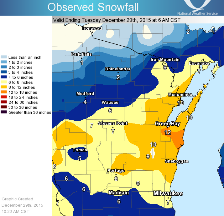
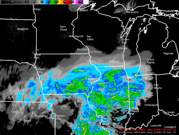
A powerful winter storm produced heavy snow across parts of central and northeast Wisconsin on December 28-29, 2015, as low pressure moved north from Arkansas to southern Lake Michigan. Green Bay officially recorded 13.2 inches, most of that falling in only eight hours. That ranks fourth for the greatest December snowstorms in Green Bay (largest occurred on December 12-13, 1909 when 16.7" fell). In addition, very gusty winds were reported across the area, creating white-out conditions across portions of east-central Wisconsin. Winds gusted over 50 mph during the height of the storm in Green Bay, Kewaunee, Algoma, and Marinette. Thundersnow was reported at several locations, including the Green Bay area and the Lake Michigan shoreline. This was the first major snowstorm of the 2015-16 winter season for central and eastern Wisconsin. At right is a radar mosaic as the storm moved across the state. (Click for full view.) |
 |
Here are the peak wind reports during the height of the winter storm:
LOCATION                     SPEED     TIME/DATE       LAT/LON

...BROWN COUNTY...
GREEN BAY AIRPORT            54 MPH    0831 PM 12/28   44.50N/88.11W
ANSTON                       36 MPH    0810 PM 12/28   44.61N/88.15W
GREENLEAF 4 NNE              31 MPH    0847 PM 12/28   44.37N/88.07W

...DOOR COUNTY...
POTAWATOMI STATE PARK 5 ESE  39 MPH    0748 PM 12/28   44.83N/87.34W
STURGEON BAY AWOS            37 MPH    0855 PM 12/28   44.84N/87.42W
POTAWATOMI STATE PARK 4 SSE  32 MPH    0800 PM 12/28   44.80N/87.40W

...KEWAUNEE COUNTY...
KEWAUNEE                     48 MPH    0818 PM 12/28   44.47N/87.50W
RANKIN 3 E                   31 MPH    0634 PM 12/28   44.60N/87.44W

...LANGLADE COUNTY...
ANTIGO 2 ENE                 37 MPH    0805 PM 12/28   45.16N/89.11W
ANTIGO AWOS                  37 MPH    0735 PM 12/28   45.15N/89.11W

...LINCOLN COUNTY...
TOMAHAWK 3 W                 30 MPH    0510 PM 12/28   45.47N/89.80W

...MANITOWOC COUNTY...
MANITOWOC AWOS               39 MPH    0826 PM 12/28   44.13N/87.68W
WAYSIDE 1 SW                 35 MPH    0726 PM 12/28   44.23N/87.96W

...MARATHON COUNTY...
MOON 6 SW                    36 MPH    0805 PM 12/28   44.70N/89.87W
WAUSAU AIRPORT               35 MPH    0739 PM 12/28   44.93N/89.63W
MOSINEE AWOS                 33 MPH    0250 PM 12/28   44.78N/89.67W

...MARINE REPORTING STATIONS...
ALGOMA CITY MARINA           61 MPH    0821 PM 12/28   44.61N/87.43W
WASHINGTON ISLAND 23 ESE     52 MPH    0800 PM 12/28   45.20N/86.50W
WHITEFISH BAY 9 SE           37 MPH    1000 AM 12/28   44.80N/87.10W

...MARINETTE COUNTY...
MENOMINEE 2 SE               53 MPH    0706 PM 12/28   45.10N/87.59W

...MENOMINEE COUNTY...
KESHENA 2 WNW                34 MPH    0805 PM 12/28   44.89N/88.66W

...OCONTO COUNTY...
OCONTO AIRPORT               37 MPH    0635 PM 12/28   44.87N/87.91W

...ONEIDA COUNTY...
RHINELANDER AIRPORT          31 MPH    0549 PM 12/28   45.63N/89.47W

...OUTAGAMIE COUNTY...
COMBINED LOCKS 2 W           45 MPH    0700 PM 12/28   44.24N/88.34W
ROSE LAWN 4 SE               42 MPH    0856 PM 12/28   44.54N/88.25W
GREENVILLE 1 E               33 MPH    0832 PM 12/28   44.29N/88.52W
APPLETON 2 ENE               31 MPH    0839 PM 12/28   44.28N/88.37W

...PORTAGE COUNTY...
PLOVER 1 WSW                 44 MPH    0747 PM 12/28   44.44N/89.55W
STEVENS POINT AIRPORT        38 MPH    0715 PM 12/28   44.55N/89.53W
PARK RIDGE 2 N               33 MPH    0715 PM 12/28   44.54N/89.54W

...SHAWANO COUNTY...
SHAWANO AIRPORT              35 MPH    0855 PM 12/28   44.79N/88.56W

...WAUPACA COUNTY...
SCANDINAVIA                  47 MPH    0724 PM 12/28   44.46N/89.15W
CLINTONVILLE AWOS            37 MPH    0855 PM 12/28   44.61N/88.73W
KING 1 ENE                   30 MPH    0659 PM 12/28   44.34N/89.12W

...WAUSHARA COUNTY...
WAUTOMA AIRPORT              43 MPH    0644 PM 12/28   44.04N/89.30W
WAUTOMA 1 WSW                32 MPH    0612 PM 12/28   44.06N/89.29W

...WINNEBAGO COUNTY...
OSHKOSH AIRPORT              46 MPH    0654 PM 12/28   43.98N/88.56W
BUTTE DES MORTS 2 WSW        43 MPH    0701 PM 12/28   44.07N/88.69W
LARSEN 2 ESE                 37 MPH    0752 PM 12/28   44.16N/88.56W
OMRO                         36 MPH    0649 PM 12/28   44.03N/88.75W
ZITTAU 3 SSE                 30 MPH    0556 PM 12/28   44.17N/88.77W

...WOOD COUNTY...
MARSHFIELD AIRPORT           39 MPH    0659 PM 12/28   44.64N/90.19W
WISCONSIN RAPIDS AIRPORT     37 MPH    0807 PM 12/28   44.36N/89.84W
PITTSVILLE                   32 MPH    0816 PM 12/28   44.45N/90.13W
NEW ROME 4 ENE               30 MPH    0705 PM 12/28   44.26N/89.81W

OBSERVATIONS ARE COLLECTED FROM A VARIETY OF SOURCES WITH VARYING
EQUIPMENT AND EXPOSURE. NOT ALL DATA LISTED ARE CONSIDERED OFFICIAL.
This was a powerful storm, and impacted much of the center of the country, ranging from snow for the Sun Bowl at El Paso in far West Texas to heavy snow in Wisconsin. Other notable impacts included large snow drifts in Texas, heavy ice accumulation in Oklahoma, tornadoes in the Dallas-Fort Worth metroplex, and record flooding on the Mississippi River.
Below is a water vapor satellite image showing this powerful storm as it lifts out of the Southern Plains and towards the Great Lakes. You can see the tremendous amount of moisture brought up to fuel our heavy snows.

Here is a visible satellite image of the storm from shortly after the snow began in Central and East Central Wisconsin. It has a tremendous span, from snow in the northern United States to a cold front that reached through the Gulf of America.

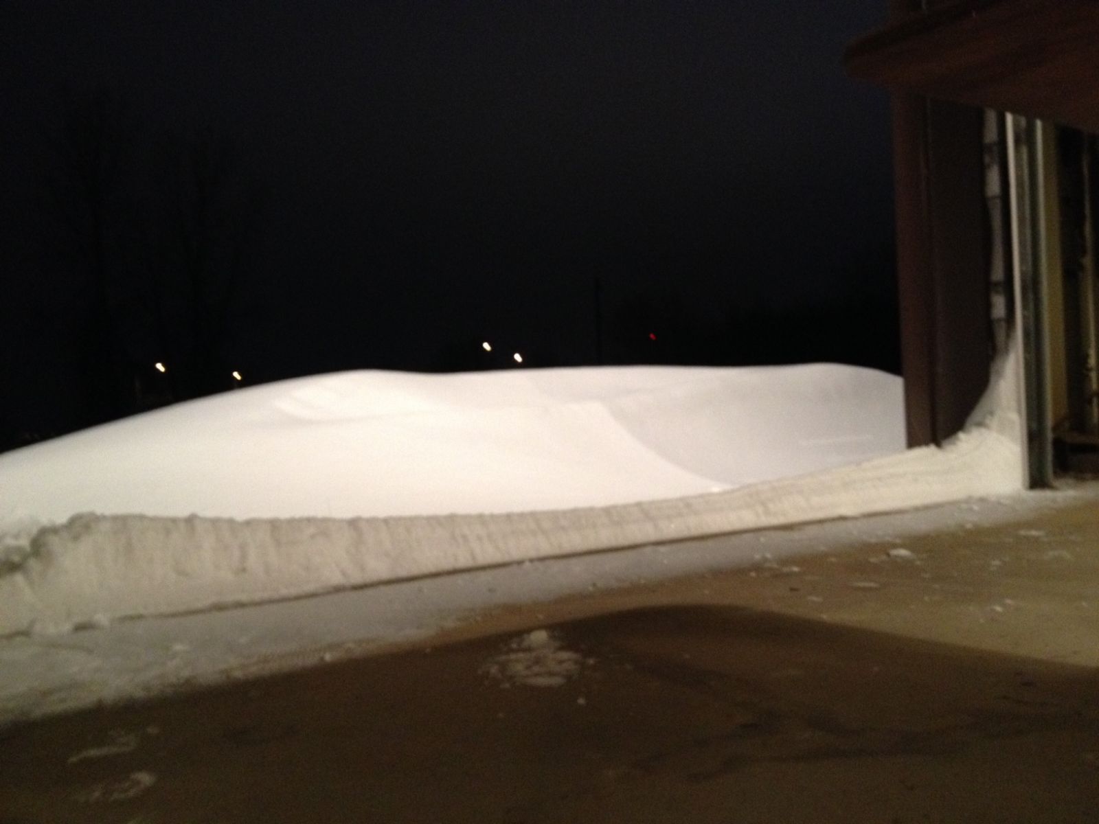
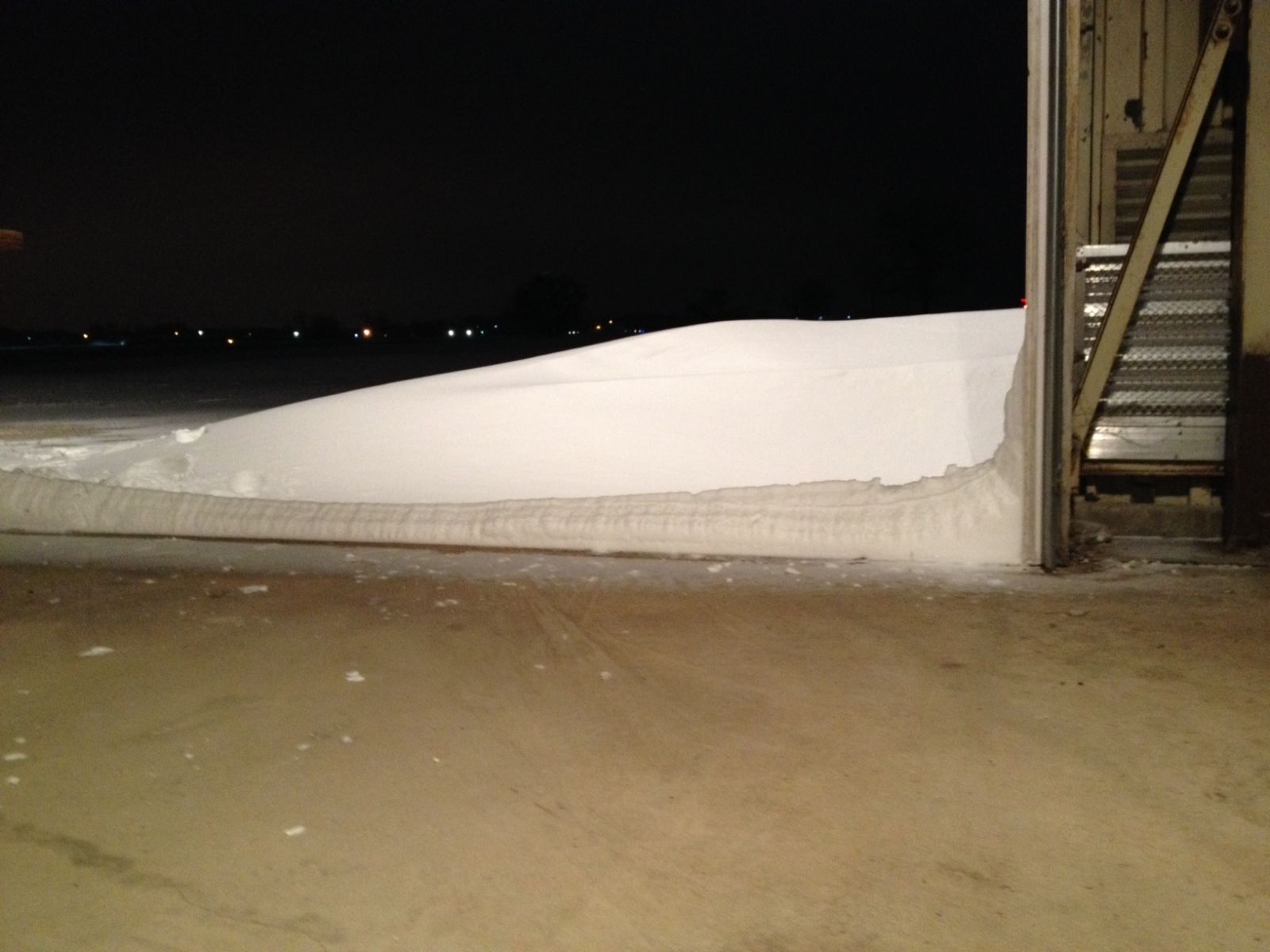
Here's a picture of the NWS Green Bay office the morning of December 29. Note the 4-5 foot drifts in front of the building.
.JPG) |
Here are some before/after pictures from December 28 vs December 29.
.JPG) |
.JPG) |
.JPG) |
.JPG) |
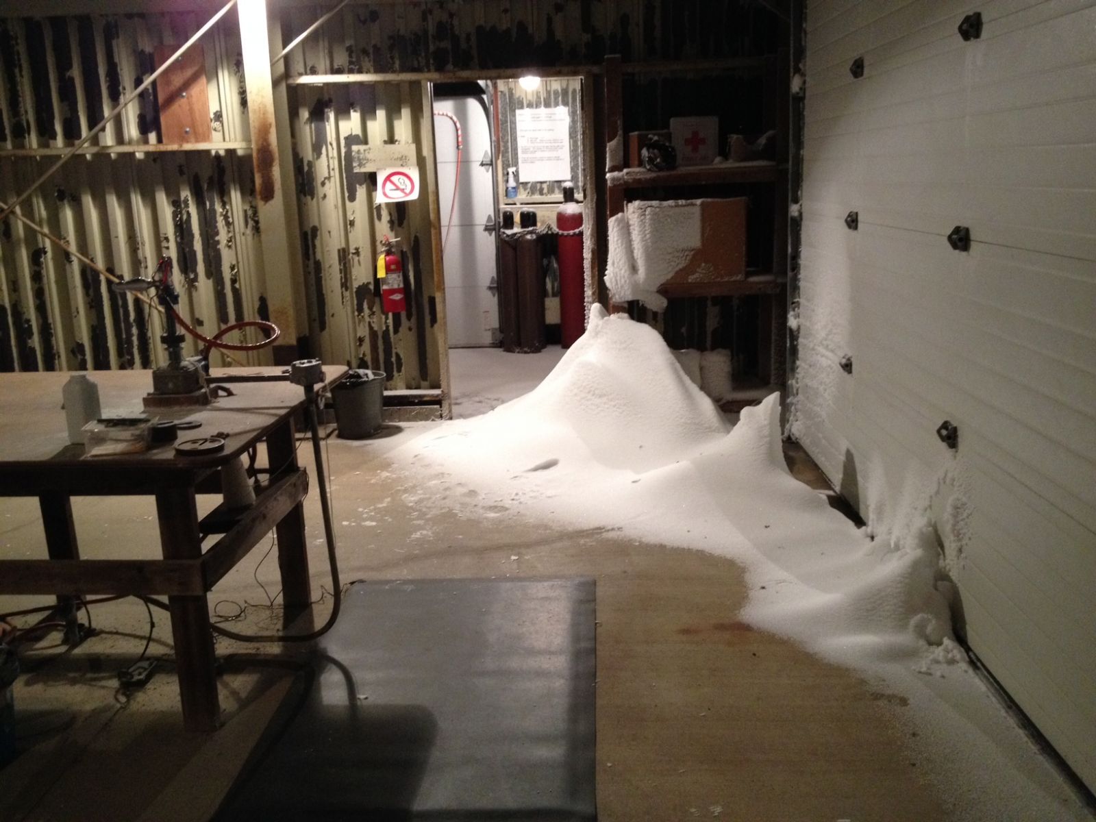
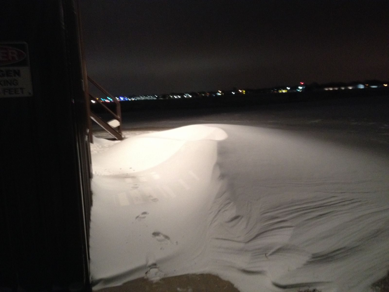
Here are pictures of the upper air building at the NWS Green Bay the morning of December 29. Drifts both inside and outside of the building!
 |
 |
 |
 |