 |
 |
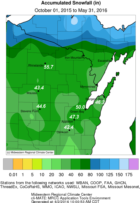
Here is the list of northeast and north-central Wisconsin snow totals, listed by amount (descending order):
                     Snowfall                      Snowfall
Location             (inches)      Location        (inches)
----------------------------------------------------------------
Land O` Lakes          90.8        Wausau             43.4
Lac Vieux Desert       90.3        Cecil - 6NE        43.3
Phelps                 76.4        Oconto             42.7
St. Germain            67.3        Oshkosh - North    42.4
Washington Island      63.2        Mountain           42.2

Eagle River            62.2        Two Rivers         42.0
Eagle River - South    58.8        Poy Sippi - 2SW    42.0
Argonne                57.0        Wausau - 3NE       41.8
Rhinelander - TV       55.7        Denmark            41.7
Aurora - 4W            55.4        Rice Reservoir     41.7

Aurora                 55.3        Wautoma            41.6
Crivitz High Falls     54.8        Stiles - 1S        41.4
Rest Lake              54.2        Valders            41.4
Florence               52.5        Kewaunee           41.3
Rhinelander - 4NE      52.2        Shiocton           41.0

Ephraim                50.7        New Hostein        40.9
Green Bay              50.0        Casco              40.5
Lake Tomahawk - 2SE    49.7        Suring             40.4
Alvin - 3 NW           49.5        Marshfield         40.3
Summit Lake            49.4        Rosholt            40.0

White Lake             48.7        Amherst            40.0
Almond - 5NE           48.3        Omro - 2SW         39.9
Antigo - 2S            48.1        Spencer            39.9
Athelstane - 2SE       47.8        Wausaukee          39.4
Crandon                47.4        Stratford          38.6

Appleton               47.3        Shawano - 4SE      38.1
Francis Creek          47.0        Merrill            37.7
Weyauwega              46.8        New London         37.6
Antigo                 46.4        Plover - South     37.5
Sturgeon Bay           46.3        Peshtigo           37.3

Amberg - 9E            46.0        Willow Reservoir   37.0
Fish Creek             46.0        Dancy - 1NE        36.5
Waupaca                45.8        Shawano            36.4
Chilton                45.6        Pittsville         36.4
Amherst - 3SE          45.4        Oshkosh            35.0

Merrill - 8W           45.4        Brillion           34.7
Big Falls - 5NW        44.9        Marinette          31.7
Ephraim - 5SE          44.8
Stevens Point          44.6
Babcock                43.8

