Green Bay, WI
Weather Forecast Office
After a very wet start to the summer, drier than normal conditions returned in August to portions of northeast Wisconsin. Locations north of Green Bay missed out on the heavy rainfall during August. The dry weather expanded across much of the area with many locations receiving between 0.50 to 1.50 inches during September, although some totals across central Wisconsin were close to 3 inches. Rainfall for September was around 20% of normal at Oconto and Washington Island. During the August and September period, Oconto received 2.82 inches (normal is 6.46 inches) or 44% of normal while Washington Island received 2.16 inches (normal is 6.35 inches) or 34% of normal. In addition, September ended at most locations as one of the top ten warmest Septembers on record with an average temperature from three to five degrees above normal. Severe Drought (D2) has expanded into northeast Wisconsin from eastern Oneida county into Florence, Forest, northeast Langlade, Marinette, northern Oconto and all of Door (except far southwest) counties.
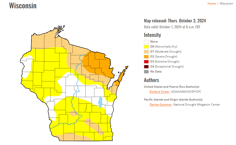
Although rain is in the forecast Saturday night, it will likely not be enough to help break the drought. The Climate Prediction Center 8-14 day outlook is calling for above normal temperatures and below normal precipitation through the middle of the month. It is likely that drought conditions will continue to worsen due to the mild temperatures and below normal precipitation.
.png)
US Dept of Commerce
National Oceanic and Atmospheric Administration
National Weather Service
Green Bay, WI
2485 South Point Road
Green Bay, WI 54313-5522
920-494-2363
Comments? Questions? Please Contact Us.

