Overview
|
An unseasonably warm and moist air mass, combined with a strong storm system, produced a severe weather outbreak on Sunday, December 28th. A number of tornadoes occurred across Illinois with this system, including three within the NWS Lincoln county warning area. |
.png) Visible satellite image from 3:01 PM CST on December 28, 2025. |
Tornadoes
Select a tornado from the table to zoom into the track and view more information. The default table view is limited to 8 tracks, but can be scrolled by a mouse wheel or dynamically expanded. Additionally, the table can fill the entire window by clicking the small circular expanding arrow icon at the very top right of the table and returned to its original size by clicking the button again. The side information panel that opens over the map can be closed using the "X" on the upper right corner of the pop-up. Zoom into the map and click damage points to see detailed information and pictures from the surveys.
|
NOTE: times shown below are local to your device's time zone. |

The Enhanced Fujita (EF) Scale classifies tornadoes into the following categories:
| EF0 Weak 65-85 mph |
EF1 Moderate 86-110 mph |
EF2 Significant 111-135 mph |
EF3 Severe 136-165 mph |
EF4 Extreme 166-200 mph |
EF5 Catastrophic 200+ mph |
 |
|||||
| Tornadoes that fail to impact any ratable damage indicators on the EF-Scale are rated EF-Unknown (EF-U) | |||||
Storm Reports
Preliminary Local Storm Report...Summary
National Weather Service Lincoln IL
526 PM CST Mon Dec 29 2025

..TIME...   ...EVENT...      ...CITY LOCATION...     ...LAT.LON...
..DATE...   ....MAG....      ..COUNTY LOCATION..ST.. ...SOURCE....
            ..REMARKS..

0900 AM     Tstm Wnd Dmg     Fairview                40.63N 90.16W
12/28/2025                   Fulton             IL   Emergency Mngr

            Power lines downed by thunderstorm winds.

0924 AM     Hail             Pekin                   40.57N 89.64W
12/28/2025  M1.00 Inch       Tazewell           IL   Public

            Relayed via broadcast media.

0924 AM     Tstm Wnd Dmg     Pekin                   40.57N 89.64W
12/28/2025                   Tazewell           IL   Emergency Mngr

            Power line downed due to thunderstorm winds.

0926 AM     Tstm Wnd Dmg     Groveland               40.59N 89.53W
12/28/2025                   Tazewell           IL   Emergency Mngr

            Power line downed due to thunderstorm winds.

0927 AM     Tornado          3 SSW Groveland         40.55N 89.56W
12/28/2025                   Tazewell           IL   Emergency Mngr

            An EF1 tornado with wind speeds up to 98 mph
            touched down along Allentown road about 3
            miles east of Pekin High School and traveled
            about 1.75 miles along that road. It
            destroyed two outbuildings and snapped off
            numerous trees along Allentown Rd. It also
            snapped off 8 power poles along Springfield
            road north of the intersection with
            Allentown Rd. Some minor roof damage
            occurred east of Springfield Road as the
            tornado dissipated.

0930 AM     Tstm Wnd Dmg     2 NW Morton             40.63N 89.49W
12/28/2025                   Tazewell           IL   Broadcast Media

            Power outage due to thunderstorm winds.

0930 AM     Tstm Wnd Dmg     3 S Groveland           40.55N 89.54W
12/28/2025                   Tazewell           IL   Emergency Mngr

            Barns destroyed. Possible tornado.

0930 AM     Tstm Wnd Dmg     3 NW Tremont            40.55N 89.53W
12/28/2025                   Tazewell           IL   Emergency Mngr

            Several power poles snapped due to
            thunderstorm winds.

0954 AM     Hail             5 NE Congerville        40.66N 89.13W
12/28/2025  M1.00 Inch       Woodford           IL   Emergency Mngr


0259 PM     Tornado          1 WNW Blue Mound        39.70N 89.14W
12/28/2025                   Macon              IL   NWS Storm Survey

            The EF-2 tornado touched down in far eastern
            Christian County where a spotter captured
            video of the tornado heading toward and
            crossing IL Route 48. The tornado remained
            weak with minimal damage until it crossed US
            Hwy 51 and reached Elwin. The damage between
            Elwin and Turpin included numerous snapped
            large trees as well as several homes with
            roof damage. Some of the more significant
            damage with this tornado occurred along E
            Skyline Drive as the tornado removed the
            majority of the roofs off of 8 homes and
            produced complete destruction of a garage
            that was tossed to the next block. Very
            large trees were also snapped off in that
            area. More home roof damage and tree damage
            occurred between S Baltimore Ave and S Mount
            Zion Rd, as the tornado crossed Bentonville
            Rd at Mount Zion Rd. The tornado weakened
            after that point, but was video taped by a
            couple of spotters progressing east all the
            way into Piatt County before dissipating
            near State Hwy 32. The tornado was on the
            ground for 34 minutes covering 23.6 miles
            with a peak wind speed of 120 mph.

0315 PM     Tornado          3 E Elwin               39.79N 88.93W
12/28/2025                   Macon              IL   Emergency Mngr

            Significant structural damage to home by a
            tornado.

0317 PM     Tstm Wnd Dmg     2 W Decatur             39.85N 88.99W
12/28/2025                   Macon              IL   Public


0318 PM     Tornado          2 NNW Mount Zion        39.80N 88.88W
12/28/2025                   Macon              IL   Emergency Mngr

            Significant structure damage to home from a
            tornado.

0318 PM     Tornado          2 NW Mount Zion         39.80N 88.89W
12/28/2025                   Macon              IL   Emergency Mngr

            8 homes destroyed by a tornado.

0319 PM     Tstm Wnd Dmg     Mount Zion              39.78N 88.87W
12/28/2025                   Macon              IL   Public

            Several trees damaged.

0319 PM     Tornado          2 WSW Long Creek        39.80N 88.87W
12/28/2025                   Macon              IL   Emergency Mngr

            Garage destroyed, roof blown off a home and
            power lines down by a tornado.

0320 PM     Tstm Wnd Dmg     2 W Mount Zion          39.78N 88.91W
12/28/2025                   Macon              IL   Public

            Multiple trees snapped. Possible tornado.
            Twitter report.

0324 PM     Tstm Wnd Dmg     4 SE Owaneco            39.44N 89.15W
12/28/2025                   Christian          IL   Emergency Mngr

            Tree downed by thunderstorm winds.

0325 PM     Tstm Wnd Dmg     3 ESE Saybrook          40.42N 88.47W
12/28/2025                   McLean             IL   Broadcast Media

            Farm outbuilding destroyed.

0330 PM     Tstm Wnd Dmg     3 WNW La Place          39.82N 88.77W
12/28/2025                   Macon              IL   Broadcast Media

            Power lines were blown down. Possible
            tornado damage. Time estimated by radar.

0355 PM     Tstm Wnd Dmg     3 NE Arthur             39.74N 88.43W
12/28/2025                   Douglas            IL   Public

            Portion of dairy barn damaged destroyed. Top
            of tree blown off.

0434 PM     Funnel Cloud     1 N Charleston          39.49N 88.18W
12/28/2025                   Coles              IL   Public


0440 PM     Tstm Wnd Dmg     3 WNW Catlin            40.08N 87.75W
12/28/2025                   Vermilion          IL   Emergency Mngr

            Multiple trees down, many shingles off roof,
            two power poles down.

0445 PM     Tornado          1 SE Redmon             39.64N 87.85W
12/28/2025                   Edgar              IL   Storm Chaser

            Brief touchdown east of Redmon. Public
            reported damage to an outbuilding.
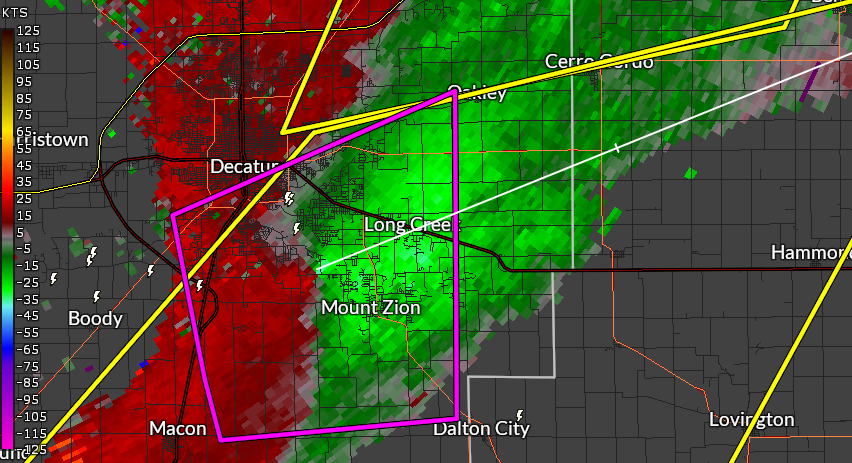
Radar
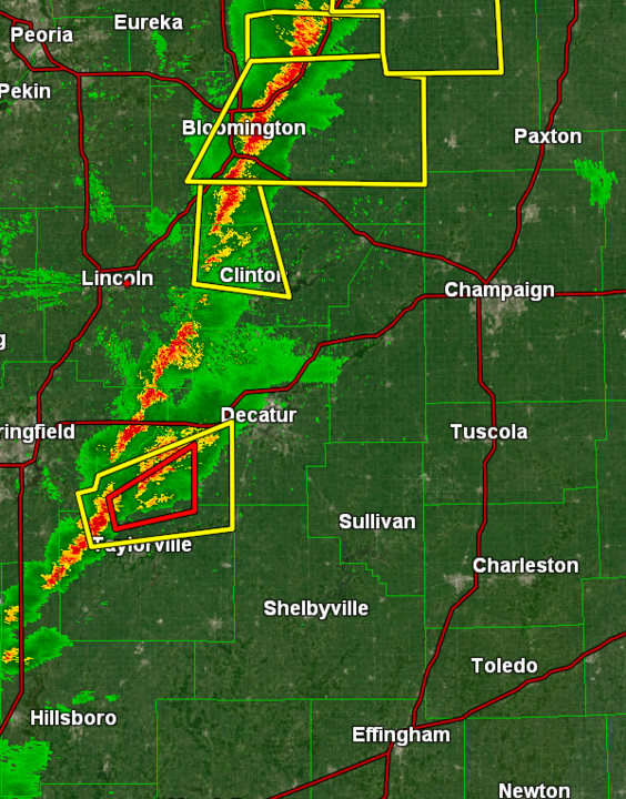 |
.png) |
 |
|
| Radar reflectivity showing a broken line of storms near/east of I-55 around 2:55 PM on December 28, 2025. Yellow boxes indicate severe thunderstorm warnings. Red boxes indicate tornado warnings. | Radar velocity showing rotation approaching Blue Mound, IL, from the southwest around 2:50 PM. A tornado warning was in effect. | Radar velocity showing a rotational couplet moving into the Mount Zion and Long Creek area. A tornado was in progress. | Caption |
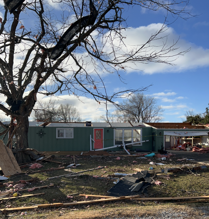
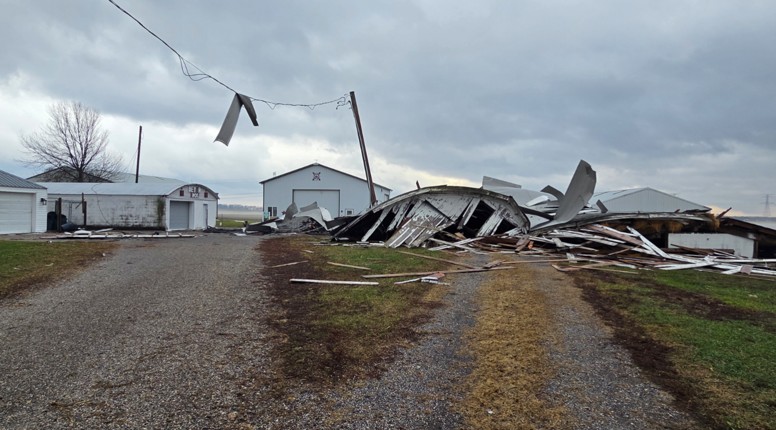
Photos & Video
Damage Photos
 |
 |
 |
 |
| Tornado damage to a residence in between Turpin and Long Creek (Photo: NWS Damage Survey) |
Tornado damage to a garage near Route 121 southeast of Decatur. (Photo: NWS Damage Survey) |
Tornado damage to a barn in Tazewell County from morning storms on December 28, 2025 (Photo: NWS Damage Survey) |
Tornado damage to a garage between Turpin and Long Creek. (Photo: NWS Damage Survey) |
Environment
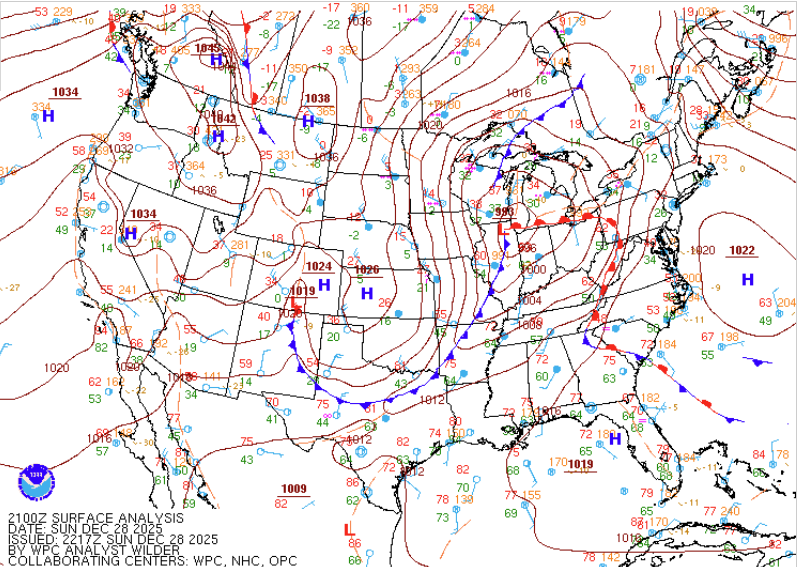
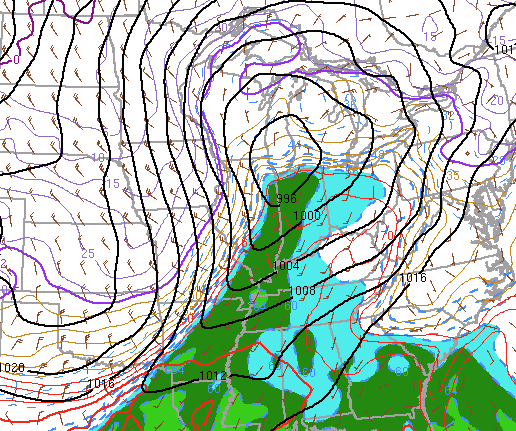
A strengthening low pressure system tracked north of the NWS Lincoln County Warning Area, and approached Chicago by mid-afternoon on Sunday, December 28th. A robust cold front extended southwestward, and swept across Illinois. The system results in some locations setting record high temperatures, with highs in the low 70s. Unseasonably high moisture content was also in place, with dewpoints above 60 degrees (green shading in Figure 2). This resulted in moderate instability (fuel), which combined with very strong wind shear led to the development of a line of strong to severe thunderstorms along the cold front.
 |
 |
|
| Figure 1: WPC surface analysis from 3 PM 12/28/25 | Figure 2: Surface temperature, dewpoint (shaded), and mean sea level pressure (black contours) | Figure 3: Caption |
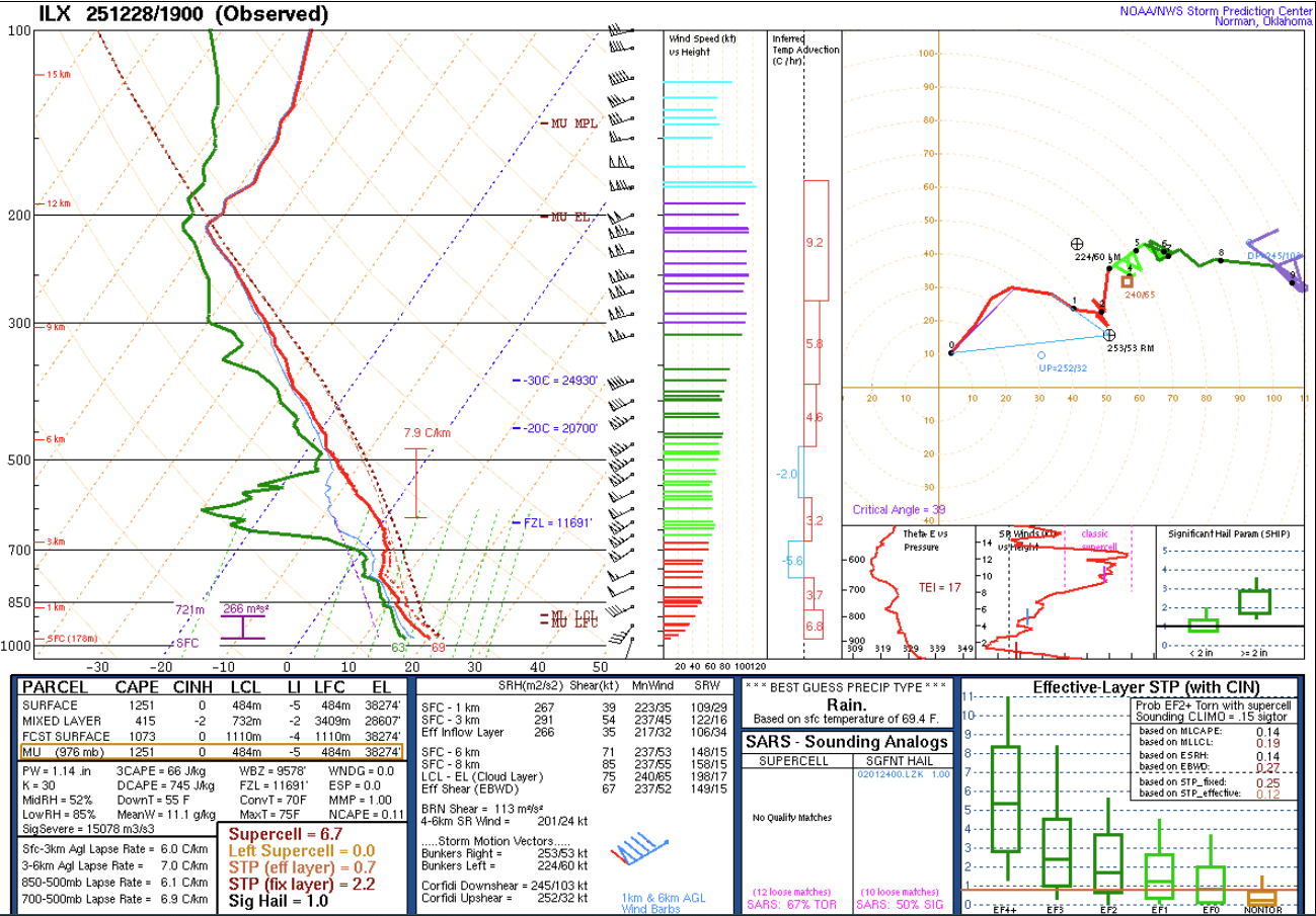
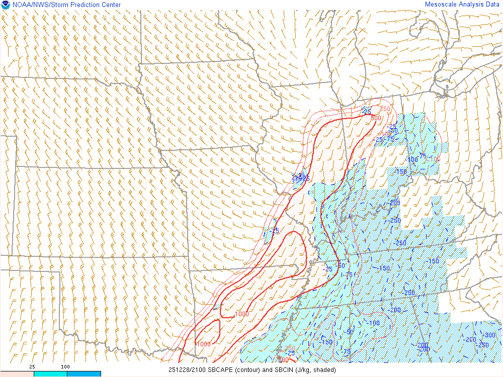
The storm environment was characterized by moderate to seasonably high instability (fuel), with surface-based CAPE values over 1000 J/kg. The dynamic system also had very strong wind shear, with low-level helicity (spin) values over 250 m2/s2. Values over 100 are often considered supportive of tornadoes, assuming other ingredients are also present.
 |
 |
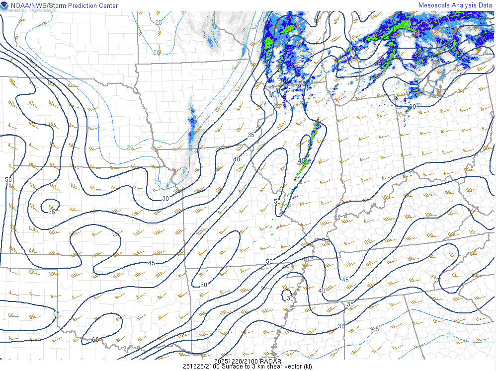 |
| Figure 4: Temperature, moisture, and wind data from the NWS Lincoln 19z (1pm) weather balloon on December 28, 2025. | Figure 5: Surface-based convective available potential energy (CAPE) (red contours). Values of 500 to 1000 indicated moderate fuel for thunderstorms. | Figure 6: Low-level (surface to 3 km AGL) wind shear. Values were over 50 knots ahead of the cold front, which is very high. |
Additional environmental data:
 |
 |
|
| Figure 7: A line chart of temperature at the Logan County Airport. Temperatures plunged on the afternoon of Dec 28 following a strong cold frontal passage. | Figure 8: 3-hour temperature change between Noon and 3 PM on December 28, 2025. Temperatures dropped as much as 30 degrees in three hours behind the front. | Figure 9: Caption |
 |
Media use of NWS Web News Stories is encouraged! Please acknowledge the NWS as the source of any news information accessed from this site. |
|

