
A significant heat wave is underway for the Intermountain West, Northern Plains, and Upper Great Lakes, peaking in intensity through midweek and lingering across parts of the Northern Plains and Midwest until this weekend. In southwest Texas, excessive rainfall may bring a risk for potentially life-threatening flash and arroyo flooding through Thursday. Read More >
Overview
|
Ahead of the main line of storms, a supercell travelled north across west central Illinois the afternoon of Friday, April 17th. This supercell produced damaging winds and 2 inch hail. The hail was wind driven and caused several houses to have siding damage and broken windows along its path. A squall line matured over west-central Illinois that evening and produced substantial straight-line wind damage, with embedded tornadoes. Preliminary reports indicate at least two dozen observed tornadoes occurred across areas mainly north of I-72, with the greatest structural damage reported near Bloomington-Normal in McLean County. This page reviews the storms that impacted the Lincoln NWS service area. Other areas can be reviewed at the following links:
|
Environment
Surface analysis from the afternoon of April 17th showed strong southerly flow across central Illinois with well above normal temperatures in the lower to middle 80s and dewpoints in the middle 60s. Meanwhile, a cold front was approaching the Mississippi River, causing winds to veer to the northwest and temperatures to drop into the 50s across central and western Iowa.
 |
 |
 |
| Figure 1: 00z 4/18/2026 Surface Analysis | Figure 2: 1630z SPC day 1 - Enhanced Risk | Figure 3: 1630z SPC day 1 hazard outlooks |
 |
 |
 |
| Figure 4: 21z SBCAPE (red contours) and SBCIN (blue shading) | Figure 5: 02z 0-1km SRH (m2/s2) and storm motion (kt) | Figure 6: 02z 0-3km bulk shear (kt) (blue contours) |
With an Enhanced Risk (level 3 of 5) for severe weather and an increasingly warm and humid airmass in place, NWS Lincoln opted to launch a special 21z/4pm weather balloon (Figure 8) to gather supplemental data. The resulting sounding showed a strongly unstable environment with Surface Based Convective Available Potential Energy (SBCAPE) of 2723J/kg and only very weak convective inhibition. Winds were southerly at the surface, then veered westerly and increased to around 50kt at 6km aloft, creating deep-layer shear on the order of 43kt. Storm relative helicity (which measures the potential for an updraft to rotate) was 118 m2/s2. The sounding also displayed an inverted-V signature, indicative of a dry sub-cloud airmass and thus an elevated risk for strong thunderstorm downdrafts. The corresponding Downward Convective Available Potential Energy (DCAPE) was an impressive 1040J/kg.
 |
 |
 |
| Figure 7: 12z 4/17/2026 ILX Sounding | Figure 8: 21z 4/17/2026 ILX Sounding | Figure 9: 00z 4/18/2026 ILX Sounding |
Radar
Review of radar images with the storms:
 |
 |
 |
| Leading supercell ahead of the main line of storms that produced a swath of damaging winds and 2 inch hail in Ipava (Fulton Co) that travelled north through the CWA. | 8:35 PM Radar Image: 3 confirmed tornado warnings, 1 radar indicated tornado warning, and 2 considerable severe thunderstorm warnings at this time along the line of thunderstorms. | 9:04 PM Radar Image: 1 confirmed tornado warning, 4 radar indicated tornado warnings, & 4 considerable severe thunderstorm warnings at this time. 3 of those tornado warnings are located over the Bloomington-Normal area. |
 |
 |
 |
| Radar reflectivity (left) and storm relative velocity (right) at 7:44 PM, showing tornadic rotation just northwest of Ipava in Fulton County. | Radar reflectivity (left) and storm relative velocity (right) at 7:23 PM, showing tornadic rotation just east of Victoria, near the Knox and Stark County line. | Radar reflectivity (left) and estimated hail size (right) at 6:21 PM, showing a supercell storm approaching Toulon in Stark County. Hail was estimated at 2 inch diameter at this time. |
Storm Reports
Preliminary Local Storm Report...Summary
National Weather Service Lincoln IL
1033 PM CDT Sat Apr 18 2026
..TIME... ...EVENT... ...CITY LOCATION... ...LAT.LON...
..DATE... ....MAG.... ..COUNTY LOCATION..ST.. ...SOURCE....
..REMARKS..
0422 PM Tstm Wnd Gst Glasgow 39.55N 90.48W
04/17/2026 M63 MPH Scott IL Emergency Mngr
0424 PM Tstm Wnd Dmg 1 E Winchester 39.63N 90.43W
04/17/2026 Scott IL Emergency Mngr
IL-106 at Woodson-Winchester Blacktop due to
downed power lines.
0424 PM Tstm Wnd Dmg 1 ENE Winchester 39.63N 90.44W
04/17/2026 Scott IL Emergency Mngr
A few commercial and residential buildings
were damaged.
0440 PM Tstm Wnd Dmg Chapin 39.76N 90.40W
04/17/2026 Morgan IL Emergency Mngr
A large shed destroyed just south of Chapin.
Time estimated by radar.
0448 PM Tstm Wnd Dmg 5 W Beardstown 40.02N 90.52W
04/17/2026 Schuyler IL Emergency Mngr
Multiple farm buildings were flattened, the
roofs of a couple machine sheds were torn
off, and 3 silos were destroyed.
0454 PM Tstm Wnd Dmg 1 S Rushville 40.10N 90.56W
04/17/2026 Schuyler IL Emergency Mngr
Several trees and tree branches were blown
down along Sugar Grove Road and at US-67 and
Watchtower Road. The entire town of
Rushville has lost power.
0459 PM Hail 4 E Rushville 40.12N 90.49W
04/17/2026 M1.75 Inch Schuyler IL Mesonet
0459 PM Tstm Wnd Gst 4 E Rushville 40.12N 90.49W
04/17/2026 E60 MPH Schuyler IL Mesonet
0500 PM Tstm Wnd Dmg 4 NW Beardstown 40.05N 90.48W
04/17/2026 Schuyler IL Emergency Mngr
US 67 closure due to tree damage near US 67
and Bluff Road.
0509 PM Hail Astoria 40.23N 90.36W
04/17/2026 M1.00 Inch Fulton IL Broadcast Media
0512 PM Hail Astoria 40.23N 90.36W
04/17/2026 M0.88 Inch Fulton IL Public
0516 PM Hail Ipava 40.35N 90.32W
04/17/2026 M2.00 Inch Fulton IL Trained Spotter
0516 PM Tstm Wnd Dmg 1 E Ipava 40.35N 90.30W
04/17/2026 Fulton IL Emergency Mngr
An industrial building has broken windows.
0522 PM Hail 4 N Ipava 40.41N 90.32W
04/17/2026 E1.00 Inch Fulton IL Emergency Mngr
0541 PM Hail Fairview 40.63N 90.16W
04/17/2026 E1.00 Inch Fulton IL Public
0541 PM Hail 3 E Fairview 40.63N 90.10W
04/17/2026 M1.00 Inch Fulton IL Trained Spotter
0557 PM Tstm Wnd Dmg Elmwood 40.78N 89.97W
04/17/2026 Peoria IL Public
Several tree branches were blown down near
the intersection of South Knox and Main
Street in Elmwood.
0601 PM Tstm Wnd Dmg 3 SSW Williamsfield 40.89N 90.04W
04/17/2026 Knox IL Trained Spotter
Reports of farm debris scattered about the
field.
0603 PM Tstm Wnd Dmg 3 SSW Williamsfield 40.89N 90.04W
04/17/2026 Knox IL Trained Spotter
flipped farm trailer, trees snapped, and
several power poles snapped. There was also
a semi flipped on I-74.
0605 PM Tstm Wnd Dmg 3 S Williamsfield 40.89N 90.01W
04/17/2026 Knox IL Trained Spotter
3 power poles snapped.
0607 PM Tstm Wnd Dmg 1 SSE Williamsfield 40.92N 90.01W
04/17/2026 Knox IL Trained Spotter
tree snapped.
0610 PM Hail 2 N Williamsfield 40.96N 90.02W
04/17/2026 M1.50 Inch Knox IL Trained Spotter
0610 PM Hail 2 NNW Laura 40.95N 89.94W
04/17/2026 M1.25 Inch Peoria IL Trained Spotter
0610 PM Hail Laura 40.92N 89.93W
04/17/2026 M1.00 Inch Peoria IL Trained Spotter
0611 PM Tstm Wnd Dmg 2 SSE Maquon 40.78N 90.15W
04/17/2026 Knox IL Broadcast Media
3-4 inch branch across the road just east of
the 97 and 8 junction.
0615 PM Tstm Wnd Dmg West Jersey 41.02N 89.93W
04/17/2026 Stark IL Trained Spotter
sheet metal barn had a roof ripped off.
0625 PM Hail Toulon 41.09N 89.86W
04/17/2026 M2.00 Inch Stark IL Public
photo shared on social media.
0728 PM Hail Toulon 41.09N 89.86W
04/17/2026 M1.75 Inch Stark IL Emergency Mngr
Siding was damaged by the hail.
0733 PM Tstm Wnd Dmg 2 ESE Avon 40.65N 90.41W
04/17/2026 Fulton IL Emergency Mngr
Numerous power poles were snapped along
North 7 Hills Road.
0745 PM Tstm Wnd Dmg Ipava 40.35N 90.32W
04/17/2026 Fulton IL Emergency Mngr
Numerous trees were blown down.
0745 PM Tstm Wnd Dmg 1 N Bernadotte 40.42N 90.33W
04/17/2026 Fulton IL Public
[Delayed Report] - Photo taken from Highway
2 looking towards Spoon River show a 50-100
yard wide path of damage through a tree
line, including snapped branches. Possible
tornado.
0750 PM Tstm Wnd Dmg 4 SSW Cuba 40.44N 90.22W
04/17/2026 Fulton IL Emergency Mngr
[Delayed Report] - Multiple buildings
damaged, one with nearly 50% loss of roofing
material, another with 20% loss of roofing
material. Debris scattered into nearby
fields. Possible tornado.
0754 PM Tornado 5 S Shirley 40.34N 89.07W
04/17/2026 McLean IL NWS Storm Survey
EF1, peak wind speed 100 mph, path length
33.8 miles. The tornado touched down about
2.5 miles southeast of Funks Grove where it
produced some tree damage along E 400 North
Rd. It progressed northeast crossing Hwy 51
just south of Randolph, causing damage to
numerous trees along the way. As it headed
toward Downs, it caused EF-1 damage to a
home and several large trees, with estimated
wind speeds of 100 mph. As the tornado moved
northeast toward Ellsworth, it caused more
tree damage and some home damage, with wind
speeds up to 100 mph. The remainder of the
tornado path were through countryside areas,
with tree damage the primary impacts. The
tornado dissipated about 1.5 miles from the
Ford County line along E 1700 North Rd.
0756 PM Tstm Wnd Dmg 1 SE Lewistown 40.39N 90.14W
04/17/2026 Fulton IL Emergency Mngr
[Delayed Report] - Tree blown down onto shed
causing structural damage. Time estimated by
radar.
0756 PM Tstm Wnd Gst Lewistown 40.40N 90.16W
04/17/2026 E65 MPH Fulton IL Emergency Mngr
0811 PM Tstm Wnd Dmg 3 ESE Dunfermline 40.46N 89.98W
04/17/2026 Fulton IL Trained Spotter
Trees were blown down.
0813 PM Tstm Wnd Dmg 1 SSW Union 40.39N 89.81W
04/17/2026 Mason IL Public
[Delayed Report] - Extensive tree damage,
with one property reporting at least 15
trees damaged. Possible tornado, NWS damage
survey will be necessary in this area. Time
estimated by radar.
0815 PM Tstm Wnd Dmg 3 S Kingston Mines 40.51N 89.79W
04/17/2026 Tazewell IL Emergency Mngr
Power line down along East Manito Rd.
0815 PM Tstm Wnd Dmg 2 NNE Oakford 40.13N 89.94W
04/17/2026 Menard IL Emergency Mngr
Trees and power lines were blown down across
Duncheon Road.
0816 PM Tstm Wnd Dmg 1 S Manito 40.42N 89.78W
04/17/2026 Mason IL Broadcast Media
Large trees broken on Glendale St.
0816 PM Tornado 5 ENE Easton 40.27N 89.76W
04/17/2026 Mason IL Trained Spotter
Tornado on the ground with debris.
0816 PM Tstm Wnd Dmg 2 E Manito 40.43N 89.74W
04/17/2026 Mason IL Public
[Delayed Report] - Multiple large trees
blown. Possible tornado.
0822 PM Tstm Wnd Dmg 2 NNE South Pekin 40.51N 89.65W
04/17/2026 Tazewell IL Emergency Mngr
12 inch limb fell on power lines.
0826 PM Tstm Wnd Dmg San Jose 40.31N 89.60W
04/17/2026 Logan IL Emergency Mngr
Power lines were blown down.
0830 PM Tstm Wnd Dmg 2 ESE Marquette Heights 40.61N 89.57W
04/17/2026 Tazewell IL Emergency Mngr
Tree blocking Cole Hollow Rd. 1 mile north
of highway 98.
0832 PM Tornado Middletown 40.10N 89.59W
04/17/2026 Logan IL Trained Spotter
0833 PM Tstm Wnd Gst 2 E Creve Coeur 40.63N 89.57W
04/17/2026 M70 MPH Tazewell IL Public
0834 PM Tstm Wnd Gst 3 SSE Tremont 40.48N 89.47W
04/17/2026 M65 MPH Tazewell IL Emergency Mngr
0834 PM Tstm Wnd Dmg 2 NNW Low Point 40.89N 89.33W
04/17/2026 Woodford IL Emergency Mngr
Machine shed collapsed, barn with roof
damage. Combine and tractor inside the shed
were also significantly damaged.
0835 PM Tstm Wnd Dmg 3 NNW Hopedale 40.46N 89.44W
04/17/2026 Tazewell IL Emergency Mngr
Grain bin moved off foundation on King Rd.
0835 PM Tstm Wnd Gst 2 WNW Morton 40.62N 89.50W
04/17/2026 M58 MPH Tazewell IL Emergency Mngr
0835 PM Tstm Wnd Dmg 2 WNW Morton 40.62N 89.50W
04/17/2026 Tazewell IL Emergency Mngr
Tree down on Roth Rd.
0835 PM Tstm Wnd Dmg 2 W Washington 40.70N 89.45W
04/17/2026 Tazewell IL Emergency Mngr
Tree limbs blocking S. Cummings Ln.
0835 PM Tornado 4 ENE Emden 40.33N 89.41W
04/17/2026 Tazewell IL Emergency Mngr
0836 PM Tstm Wnd Dmg 3 E Tremont 40.53N 89.43W
04/17/2026 Tazewell IL Public
[Delayed Report] - Numerous trees damaged
around Lake Windermere, including large
limbs broken and small trees uprooted.
Shingle damage also occurred at one
residence. Photos were provided.
0837 PM Tstm Wnd Gst Washburn 40.92N 89.29W
04/17/2026 E60 MPH Woodford IL Trained Spotter
0838 PM Tstm Wnd Dmg 1 SE Morton 40.61N 89.45W
04/17/2026 Tazewell IL Broadcast Media
Power lines were blown across Jefferson
Street.
0843 PM Tstm Wnd Dmg 4 ESE Mackinaw 40.51N 89.29W
04/17/2026 Tazewell IL Public
[Delayed Report] - Extensive tree damage,
including a maple tree blown down and two
large pine trees snapped. Personal weather
station measured 78 mph at this same
time/location. Possible tornado.
0843 PM Tstm Wnd Gst 4 ESE Mackinaw 40.51N 89.29W
04/17/2026 M78 MPH Tazewell IL Public
0846 PM Tstm Wnd Dmg 1 SE Deer Creek 40.62N 89.32W
04/17/2026 Woodford IL Emergency Mngr
A semi was blown over on I-74 near mile
marker 108.
0850 PM Tstm Wnd Dmg Elkhart 40.02N 89.48W
04/17/2026 Logan IL Emergency Mngr
A tree was blown down across Gillett Street.
0850 PM Tstm Wnd Dmg 4 E Mackinaw 40.54N 89.27W
04/17/2026 Tazewell IL Broadcast Media
[Delayed Report] - Power pole blown over
with structural damage to a large farm
outbuilding. Possible tornado. Time
estimated by radar.
0853 PM Tstm Wnd Dmg Carlock 40.58N 89.13W
04/17/2026 McLean IL Emergency Mngr
Multiple trees and power lines were blown
down.
0855 PM Tstm Wnd Dmg 1 N Shirley 40.43N 89.06W
04/17/2026 McLean IL NWS Employee
Power line down.
0855 PM Tstm Wnd Dmg Shirley 40.42N 89.06W
04/17/2026 McLean IL NWS Employee
Tree broken.
0855 PM Tstm Wnd Dmg Shirley 40.41N 89.06W
04/17/2026 McLean IL NWS Employee
Grain bins destroyed.
0855 PM Tstm Wnd Dmg 3 WNW Bloomington 40.49N 89.04W
04/17/2026 McLean IL Trained Spotter
Numerous trees and power lines were blown
down along West Market Street.
0855 PM Tstm Wnd Dmg 3 SSE Carlock 40.55N 89.12W
04/17/2026 McLean IL Emergency Mngr
[Delayed Report] - Several large tree limbs
broken. Damage to the metal roof of a large
outbuilding.
0857 PM Tornado 2 SSW Bloomington 40.45N 89.01W
04/17/2026 McLean IL NWS Storm Survey
EF1, peak wind speed 100 mph, path length
1.3 miles. This tornado set down next to
Veteran Parkway doing minor damage to two
greenhouses. It traveled near the highway
and into Highland Park Golf Course where it
did only tree damage. It ended before
reaching Main Street.
0857 PM Tornado 3 WNW Bloomington 40.50N 89.05W
04/17/2026 McLean IL NWS Storm Survey
EF1, peak wind speed 110 mph, path length
10.3 miles. This tornado touched down on the
far west side of Normal, IL and damaged
several metal buildings. As it moved
northeast across town, it did significant
tree damage, especially between Main Street
and North Linden Street. It continued to do
tree damage as it moved northeast. As it
left town, it flipped over a semi on I-55.
It then entered Towanda, doing minor damage
and ended just northeast of town.
0857 PM Tstm Wnd Dmg 4 W Normal 40.51N 89.06W
04/17/2026 McLean IL Emergency Mngr
The roof and some of the walls of a new
building at the Rivian Manufacturing Center
collapsed.
0857 PM Tstm Wnd Dmg 2 S Minonk 40.87N 89.03W
04/17/2026 Woodford IL Emergency Mngr
A power pole was snapped along IL-251 just
north of its intersection with IL-116.
0857 PM Tstm Wnd Dmg Minonk 40.90N 89.03W
04/17/2026 Woodford IL Emergency Mngr
Power lines were blown down across IL-251.
0857 PM Tstm Wnd Gst Minonk 40.90N 89.03W
04/17/2026 E60 MPH Woodford IL Emergency Mngr
0900 PM Tornado 2 ENE Bloomington 40.48N 88.97W
04/17/2026 McLean IL NWS Storm Survey
EF1, peak wind speed 110 mph, path length
4.0 miles. This tornado touched down in the
Bloomington Country Club Golf Course and did
tree damage. As it moved northeast it broke
two power poles on Empire St and then
traveled across Veterans Parkway into a
housing area. It did significant tree damage
as it moved northeast and then broke two
more power poles on GE Road. It continued
northeast, doing more tree damage and then
weakened and ended near the intersection of
Fort Jesse Road and Towanda Barnes Road.
0900 PM Tstm Wnd Dmg 2 N Normal 40.54N 88.98W
04/17/2026 McLean IL Public
Tree uprooted at Ironwood Gardens.
0900 PM Tstm Wnd Dmg 1 SSE Bloomington 40.47N 88.99W
04/17/2026 McLean IL Public
Large tree snapped at Evergreen Cemetery.
0900 PM Tstm Wnd Dmg 1 ENE Bloomington 40.48N 88.97W
04/17/2026 McLean IL Public
Several trees downed on east side of
Bloomington Country Club.
0900 PM Tstm Wnd Dmg 2 NNW Central Illinois 40.50N 88.93W
04/17/2026 McLean IL NWS Employee
A large tree was blown down onto a parked
car. Chunks of shingles and gutters were
blown off structures.
0900 PM Tstm Wnd Dmg 1 WNW Bloomington 40.49N 89.01W
04/17/2026 McLean IL Public
A large tree was blown over on Livingston
Street.
0900 PM Tstm Wnd Dmg 2 NNW Central Illinois 40.50N 88.93W
04/17/2026 McLean IL NWS Employee
Numerous trees were blown down on Gill
Street.
0900 PM Tstm Wnd Dmg 2 ESE Normal 40.50N 88.95W
04/17/2026 McLean IL Broadcast Media
Power poles were snapped along GE Road.
0900 PM Tstm Wnd Dmg 1 NW Normal 40.52N 89.00W
04/17/2026 McLean IL Public
[Delayed Report] - Photos show large trees
broken near the base at the ISU Golf Course
and U High Soccer Field. Metal bleachers
were also overturned.
0900 PM Tstm Wnd Dmg Bloomington 40.48N 88.99W
04/17/2026 McLean IL Public
[Delayed Report] - Southwest facing parapet
wall of a building was blown over.
0901 PM Tstm Wnd Dmg 3 NNE Central Illinois 40.52N 88.90W
04/17/2026 McLean IL Public
[Delayed report] - Speed limit sign blown
over and pushed into yard.
0901 PM Tstm Wnd Dmg 2 NNW Central Illinois 40.50N 88.93W
04/17/2026 McLean IL NWS Employee
[Delayed Report] - Half of a large tree
blown down onto a home. Also noted some
trees blown onto parked vehicles along this
block.
0903 PM Tstm Wnd Dmg 3 WSW Towanda 40.55N 88.95W
04/17/2026 McLean IL Public
[Delayed Report] - Photo showing residential
fence blown apart by storm winds. Possible
tornado.
0904 PM Tstm Wnd Gst Central Illinois Airpor 40.47N 88.91W
04/17/2026 M66 MPH McLean IL AWOS
0905 PM Tstm Wnd Dmg 1 N Normal 40.52N 88.98W
04/17/2026 McLean IL Public
Significant tree damage across much of north
Normal.
0905 PM Tstm Wnd Dmg Normal 40.51N 88.98W
04/17/2026 McLean IL Trained Spotter
Numerous power poles were snapped along
College Avenue and near the intersection of
South Main Street and East Lincoln Street.
0905 PM Tstm Wnd Dmg Downs 40.40N 88.87W
04/17/2026 McLean IL Emergency Mngr
Power poles were blown down.
0905 PM Tstm Wnd Dmg 1 NW Normal 40.52N 88.99W
04/17/2026 McLean IL Public
0906 PM Tstm Wnd Dmg 1 S Kenney 40.09N 89.09W
04/17/2026 De Witt IL Emergency Mngr
[Delayed Report] - Two power poles down on
Kenney Road. Possible tornado, NWS damage
survey will be necessary in this area. Time
estimated by radar.
0906 PM Tstm Wnd Dmg Downs 40.40N 88.87W
04/17/2026 McLean IL Emergency Mngr
A home was heavily damaged.
0906 PM Tstm Wnd Gst Normal 40.51N 88.98W
04/17/2026 M85 MPH McLean IL Public
Wind gust measured with anemometer.
0908 PM Tstm Wnd Dmg 3 WSW Kenney 40.08N 89.13W
04/17/2026 De Witt IL Emergency Mngr
A large tree limb was blown down onto IL-54
one mile east of the Logan/DeWitt County
line.
0909 PM Tstm Wnd Gst Towanda 40.56N 88.90W
04/17/2026 M82 MPH McLean IL Public
Peak gust before power was lost.
0912 PM Tstm Wnd Dmg 4 E Towanda 40.56N 88.82W
04/17/2026 McLean IL Public
Machine shed destroyed.
0916 PM Tstm Wnd Dmg 2 ENE Maroa 40.06N 88.92W
04/17/2026 De Witt IL Broadcast Media
[Delayed Report] - Structural damage to a
large outbuilding.
0918 PM Tstm Wnd Dmg 1 NNE Colfax 40.58N 88.61W
04/17/2026 McLean IL Emergency Mngr
Two barns were destroyed.
0918 PM Tstm Wnd Dmg 2 N Pleasant Hill 40.64N 88.75W
04/17/2026 McLean IL Public
[Delayed Report] - Social media photo shows
structural damage to large farm outbuilding.
0919 PM Tornado 4 E Pleasant Hill 40.61N 88.67W
04/17/2026 McLean IL NWS Storm Survey
EF1, path length 7.9 miles, peak wind speed
90 mph. The tornado began in rural northeast
McLean County about 4 miles northwest of
Colfax, damaging trees and power poles and
power lines. The tornado crossed into
Livingston County, damaging more trees and a
machine shed.
0926 PM Tstm Wnd Dmg Saybrook 40.43N 88.53W
04/17/2026 McLean IL Emergency Mngr
[Delayed Report] - Multiple trees down in
Saybrook, including one completely uprooted
resulting in damage to vehicle. Another tree
was snapped in half onto a garage. Possible
tornado, NWS damage survey will be necessary
in this area. Time estimated by radar.
0928 PM Tstm Wnd Dmg 4 SSW Cuba 40.44N 90.22W
04/17/2026 Fulton IL 911 Call Center
Missing roof and barn destroyed. Possible
tornado. Time estimated from radar.
0928 PM Tstm Wnd Dmg Cropsey 40.61N 88.48W
04/17/2026 McLean IL Broadcast Media
Power line down.
0935 PM Tstm Wnd Dmg 3 SW Lodge 40.07N 88.61W
04/17/2026 Piatt IL Broadcast Media
[Delayed Report] - Farm outbuilding
destroyed. Possible tornado.
0940 PM Tstm Wnd Dmg 3 SW Lodge 40.08N 88.61W
04/17/2026 Piatt IL Public
0940 PM Tstm Wnd Dmg 1 ESE Mackinaw 40.53N 89.35W
04/17/2026 Tazewell IL Broadcast Media
A grain bin was blown into a ditch and
several power lines were downed.
0942 PM Tstm Wnd Dmg 2 SW White Heath 40.07N 88.55W
04/17/2026 Piatt IL Broadcast Media
Power pole down.
0942 PM Tstm Wnd Gst Decatur Airport 39.83N 88.86W
04/17/2026 M58 MPH Macon IL ASOS
0952 PM Tstm Wnd Dmg 1 ENE Seymour 40.11N 88.41W
04/17/2026 Champaign IL Emergency Mngr
A power pole was leaning over near Route 47
just east of Seymour.
1003 PM Tstm Wnd Dmg Urbana 40.11N 88.21W
04/17/2026 Champaign IL Emergency Mngr
A large tree was snapped on Broadway Avenue.
1004 PM Tstm Wnd Gst Willard Airport 40.04N 88.28W
04/17/2026 M59 MPH Champaign IL ASOS
1045 PM Tstm Wnd Dmg 1 SE Tilton 40.09N 87.64W
04/17/2026 Vermilion IL Broadcast Media
Power pole down on Leonard St.
1045 PM Tstm Wnd Dmg 1 SE Tilton 40.09N 87.64W
04/17/2026 Vermilion IL Emergency Mngr
A tree was blown over at IL Route 1 and
Moore Street.
1045 PM Tstm Wnd Dmg 1 SSE Tilton 40.09N 87.64W
04/17/2026 Vermilion IL Broadcast Media
[Delayed Report] - Several trees blown over
onto roadways around Tilton. At least one
power pole was broken, with others leaning.
&&

$$
Tornadoes
Select a tornado from the table to zoom into the track and view more information. The default table view is limited to 8 tracks, but can be scrolled by a mouse wheel or dynamically expanded. Additionally, the table can fill the entire window by clicking the small circular expanding arrow icon at the very top right of the table and returned to its original size by clicking the button again. The side information panel that opens over the map can be closed using the "X" on the upper right corner of the pop-up. Zoom into the map and click damage points to see detailed information and pictures from the surveys.
NOTE: Tornadoes that crossed NWS Service Areas will NOT appear in the tornado dashboard (table) below, but will on the map.
|
NOTE: times shown below are local to your device's time zone. |

The Enhanced Fujita (EF) Scale classifies tornadoes into the following categories:
| EF0 Weak 65-85 mph |
EF1 Moderate 86-110 mph |
EF2 Significant 111-135 mph |
EF3 Severe 136-165 mph |
EF4 Extreme 166-200 mph |
EF5 Catastrophic 200+ mph |
 |
|||||
| Tornadoes that fail to impact any ratable damage indicators on the EF-Scale are rated EF-Unknown (EF-U) | |||||
Photos & Video
Damage pictures
 |
 |
 |
 |
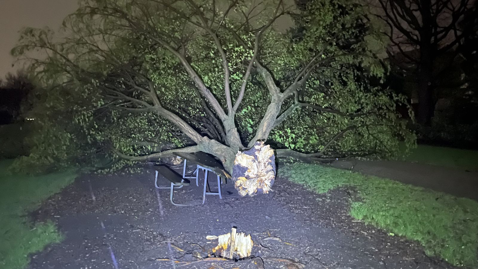
| Large tree snapped at base in Clearwater Park in Bloomington IL (NWS Employee) |
Significant tree damage in southwest Fulton County (NWS Damage Survey) |
Tornado picture captured near Mason City (Source: Joshua Henkels) |
Siding damage from the wind driven hail within the afternoon supercell ahead of the main line of storms. (City of Galva ESDA) |
 |
 |
 |
 |
| Large machine shed destroyed in southwest Fulton County (NWS Damage Survey) |
New grain bin destroyed in southwest Fulton County (NWS Damage Survey) |
Garage destroyed in eastern Tazewell County (NWS Damage Survey) |
Large machine shed destroyed in southern Tazewell County (NWS Damage Survey) |
 |
Media use of NWS Web News Stories is encouraged! Please acknowledge the NWS as the source of any news information accessed from this site. |
|

