
Flash flooding threatens areas from the Tennessee Valley to the Carolinas as storms repeat along a stalled front. Monsoonal storms may trigger flooding in the Southwest. Dangerous heat expands across the Desert Southwest, Plains, mid-Mississippi Valley and Southern Tier. Critical fire weather for interior Pacific Northwest. Cooler, drier air brings brief relief to the Great Lakes and Northeast. Read More >
Overview
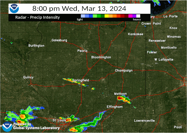
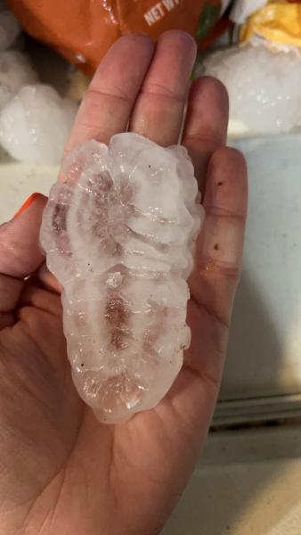
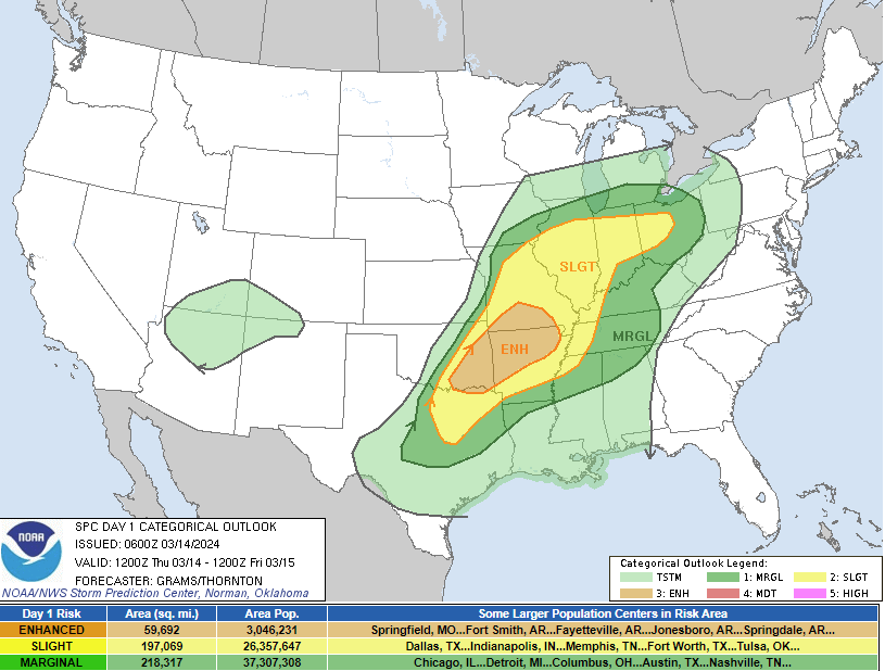
A strong low pressure system brought three rounds of thunderstorms to central and southeast Illinois between Wednesday night, March 13th and Thursday evening, March 14th. The first round arrived late Wednesday evening of March 13 when a warm front lifted north through the area. The storms produced large to very large hail in central and eastern Illinois, with golf ball size hail (1.75") reported south of Mattoon. A line of storms brought another round of severe weather on Thursday morning. Strong winds and sporadic large hail were the primary hazards reported with this round. The third and final wave of storms occurred late Thursday afternoon and evening of March 14, with several discrete supercells producing significant hail, damaging winds, and a few funnel clouds. The largest hail from the event occurred in Nortinville, IL (Morgan Co.) where a handful of significant stones measures 2-4" in diameter.
This page will continue to be updated.
Tornadoes:
|
Tornado - LOCATION
Track Map 
Downloadable KMZ File |
||||||||||||||||
|
Tornado - LOCATION
Track Map
Downloadable KMZ File |
||||||||||||||||
|
Tornado - LOCATION
Track Map
Downloadable KMZ File |
||||||||||||||||
The Enhanced Fujita (EF) Scale classifies tornadoes into the following categories:
| EF0 Weak 65-85 mph |
EF1 Moderate 86-110 mph |
EF2 Significant 111-135 mph |
EF3 Severe 136-165 mph |
EF4 Extreme 166-200 mph |
EF5 Catastrophic 200+ mph |
 |
|||||
Photos & Video
Header
 |
 |
||
| 4 inch hailstone reported in Nortinville, IL in Morgan County (Photo by Khrysten Tipps) |
Significant hail reported in Nortinville, IL in Morgan County (Photo by Khrysten Tipps) |
Caption (source) |
Caption (source) |
Radar
Header
| Caption | Caption | Caption | Caption |
Storm Reports
Preliminary Local Storm Report...Summary
National Weather Service Lincoln IL
957 PM CDT Thu Mar 14 2024

..TIME...   ...EVENT...      ...CITY LOCATION...     ...LAT.LON...
..DATE...   ....MAG....      ..COUNTY LOCATION..ST.. ...SOURCE....
            ..REMARKS..

0855 PM     Tstm Wnd Gst     Mount Carmel Airport    38.61N 87.73W
03/14/2024  M61 MPH          Lawrence           IL   AWOS


0715 PM     Funnel Cloud     5 SW Louisville         38.72N 88.57W
03/14/2024                   Clay               IL   Public

            Corrects previous funnel cloud report from 5
            SW Louisville. ESDA coordinator relayed a
            delayed report from public of a funnel cloud
            moving NE 5 miles SW of Louisville.

0639 PM     Funnel Cloud     Neoga                   39.32N 88.45W
03/14/2024                   Cumberland         IL   Trained Spotter

            Observed a funnel for a couple minutes near
            Neoga.

0638 PM     Funnel Cloud     1 NE Neoga              39.33N 88.44W
03/14/2024                   Cumberland         IL   Trained Spotter

            Funnel cloud spotted to the west of the
            Neoga exit on I-57, north of Neoga.

0555 PM     Tstm Wnd Dmg     Findlay                 39.52N 88.75W
03/14/2024                   Shelby             IL   Public

            relayed via broadcast media. photos of a
            small outbuilding/shed flipped over and a
            pine tree broken at the trunk. time
            estimated from radar.

0555 PM     Hail             Oconee                  39.29N 89.11W
03/14/2024  M1.25 inch       Shelby             IL   Broadcast Media

            Delayed report from WCIA broadcast
            meteorologist of half dollar hail in Oconee.

0532 PM     Hail             5 NW Assumption         39.58N 89.11W
03/14/2024  M1.25 inch       Christian          IL   Public

            relayed via social media post.

0524 PM     Hail             Taylorville             39.55N 89.30W
03/14/2024  M1.25 inch       Christian          IL   Trained Spotter

            Measured half dollar hail east side of
            Taylorville from a trained spotter.

0515 PM     Tstm Wnd Dmg     Kincaid                 39.59N 89.41W
03/14/2024                   Christian          IL   Trained Spotter

            social media photo of a large tree branch
            down. time estimated from radar.

0511 PM     Funnel Cloud     1 SSE Pawnee            39.58N 89.57W
03/14/2024                   Sangamon           IL   Public


0507 PM     Funnel Cloud     2 SW Pawnee             39.57N 89.61W
03/14/2024                   Sangamon           IL   Emergency Mngr


0504 PM     Hail             Pawnee                  39.59N 89.58W
03/14/2024  M1.00 inch       Sangamon           IL   Public

            photo of quarter size hail sent via social
            media. Time estimated from radar.

0437 PM     Hail             Franklin                39.62N 90.05W
03/14/2024  M1.00 inch       Morgan             IL   Emergency Mngr


0423 PM     Hail             Nortonville             39.56N 90.14W
03/14/2024  M4.00 inch       Morgan             IL   Public

            broadcast media posted a picture of very
            large hailstones ranging from 3 to 4 inches.

0421 PM     Hail             Murrayville             39.58N 90.25W
03/14/2024  M1.75 inch       Morgan             IL   Emergency Mngr

            Morgan Co reported golfball sized hail in
            Murrayville.

0417 PM     Hail             1 E Murrayville         39.58N 90.23W
03/14/2024  M1.25 inch       Morgan             IL   Trained Spotter

            delayed report.

0404 PM     Hail             Winchester              39.63N 90.46W
03/14/2024  M1.75 inch       Scott              IL   Emergency Mngr

            Scott Co EMA called to report golf ball
            sized hail in Winchester.

1025 AM     Rain             Knoxville               40.91N 90.29W
03/14/2024  M1.46 inch       Knox               IL   Mesonet

            SWOP Observer.

0933 AM     Hail             Georgetown              39.97N 87.63W
03/14/2024  M0.88 inch       Vermilion          IL   Public


0915 AM     Rain             Wataga                  41.03N 90.28W
03/14/2024  M1.24 inch       Knox               IL   Mesonet

            SWOP Observer.

0829 AM     Hail             2 SSW Cadwell           39.65N 88.55W
03/14/2024  M1.00 inch       Moultrie           IL   Public

            Delayed report. Relayed from broadcast
            media. Time estimated from radar.

0800 AM     Rain             Knoxville               40.90N 90.29W
03/14/2024  M1.46 inch       Knox               IL   CO-OP Observer

            CO-OP Observer station KNXI2 Knoxville.

0700 AM     Rain             1 W Galesburg           40.95N 90.39W
03/14/2024  M1.51 inch       Knox               IL   CO-OP Observer

            CO-OP Observer station GBGI2 Galesburg.

0700 AM     Rain             4 N Victoria            41.09N 90.08W
03/14/2024  M1.19 inch       Knox               IL   Cocorahs

            Cocorahs station IL-KX-22 Altona 4.7 ESE.

0700 AM     Rain             1 NW Knoxville          40.91N 90.29W
03/14/2024  M1.03 inch       Knox               IL   Cocorahs

            Cocorahs station IL-KX-9 Knoxville 0.7 NW.

0600 AM     Rain             Altona                  41.12N 90.16W
03/14/2024  M1.63 inch       Knox               IL   CO-OP Observer

            CO-OP Observer station AOAI2 Altona.

0528 AM     Hail             Chillicothe             40.92N 89.49W
03/14/2024  M0.88 inch       Peoria             IL   Amateur Radio

            Nickel size hail reported for about a
            minute.

1215 AM     Hail             Stanford                40.44N 89.22W
03/14/2024  E0.75 inch       McLean             IL   Public

            Report from mPING: Dime (0.75 in.).

1213 AM     Hail             Farmington              40.70N 90.01W
03/14/2024  M0.75 inch       Fulton             IL   Emergency Mngr


1130 PM     Hail             Elkhart                 40.02N 89.48W
03/13/2024  M1.00 inch       Logan              IL   Public

            Relayed via WCIA-TV.

1010 PM     Hail             4 SSE Vermilion         39.52N 87.57W
03/13/2024  E0.75 inch       Edgar              IL   Public

            dime to penny size hail. relayed via
            broadcast media.
Rain Reports
Public Information Statement
National Weather Service Lincoln IL
1213 PM CDT Fri Mar 15 2024

...2 DAY RAINFALL REPORTS...

Location                     Amount    Time/Date       Lat/Lon

...Illinois...

...Cass County...
Beardstown                   0.65 in   1120 AM 03/15   40.00N/90.37W

...Champaign County...
Sidney 0.9 N                 0.65 in   0620 AM 03/15   40.04N/88.07W
Philo                        0.65 in   0700 AM 03/15   40.00N/88.15W
Homer 2.0 N                  0.63 in   0700 AM 03/15   40.06N/87.96W
Homer 2.1 NNE                0.62 in   0700 AM 03/15   40.06N/87.95W
Broadlands 0.1 SSW           0.53 in   1201 AM 03/15   39.91N/88.00W
Philo 0.3 NE                 0.52 in   0700 AM 03/15   40.01N/88.15W
Homer 2.0 WSW                0.44 in   0700 AM 03/15   40.02N/88.00W
St. Joseph 1.1 ENE           0.43 in   0600 AM 03/15   40.12N/88.02W
Mahomet 1.8 ENE              0.42 in   0700 AM 03/15   40.20N/88.37W
Mahomet 1.6 E                0.40 in   0645 AM 03/15   40.20N/88.37W
Champaign County             0.40 in   0700 AM 03/15   39.97N/88.35W
Rantoul 1.1 NE               0.39 in   0421 AM 03/15   40.32N/88.14W
Ogden                        0.39 in   0600 AM 03/15   40.11N/87.96W
1 NE Rantoul                 0.36 in   0800 AM 03/15   40.32N/88.14W
3 NNE Villa Grove            0.36 in   1115 AM 03/15   39.91N/88.14W
Urbana                       0.34 in   0700 AM 03/15   40.10N/88.20W
Urbana 1.2 NNE               0.33 in   0700 AM 03/15   40.13N/88.20W
Savoy 0.6 SSE                0.33 in   0700 AM 03/15   40.06N/88.25W
Mahomet                      0.33 in   0815 AM 03/15   40.20N/88.41W

...Christian County...
Edinburg 3.0 W               0.61 in   0700 AM 03/15   39.65N/89.45W
Taylorville 0.6 ENE          0.46 in   0700 AM 03/15   39.53N/89.25W
2.5 W Taylorville            0.38 in   0700 AM 03/15   39.53N/89.31W
Morrisonville 0.5 SSE        0.37 in   0730 AM 03/15   39.41N/89.45W

...Clark County...
Marshall                     1.34 in   1105 AM 03/15   39.41N/87.68W
Casey                        0.53 in   0730 AM 03/15   39.30N/87.97W

...Clay County...
Flora                        0.90 in   0630 AM 03/15   38.68N/88.48W
Clay City 6 SSE              0.83 in   0600 AM 03/15   38.61N/88.31W

...Coles County...
Charleston 4.7 SSW           1.95 in   0800 AM 03/15   39.42N/88.19W
Mattoon 0.5 NW               0.88 in   0700 AM 03/15   39.48N/88.38W
Coles Co. Mem AP             0.66 in   1119 AM 03/15   39.47N/88.27W

...Crawford County...
2.0 W Robinson               0.55 in   0700 AM 03/15   39.01N/87.78W
Hutsonville                  0.54 in   0645 AM 03/15   39.11N/87.67W

...De Witt County...
Waynesville                  0.62 in   1115 AM 03/15   40.26N/89.04W
Clinton 0.4 WSW              0.45 in   0700 AM 03/15   40.15N/88.97W

...Douglas County...
Tuscola 0.6 NNE              0.65 in   0830 AM 03/15   39.81N/88.28W
Arcola                       0.63 in   1115 AM 03/15   39.69N/88.42W
Camargo 4.5 ESE              0.62 in   0722 AM 03/15   39.78N/88.09W
Tuscola 0.5 WSW              0.58 in   0700 AM 03/15   39.79N/88.29W
Camargo                      0.57 in   1115 AM 03/15   39.81N/88.16W
Newman                       0.55 in   0600 AM 03/15   39.79N/87.98W
1.5 NE Chesterville          0.35 in   1100 AM 03/15   39.70N/88.39W

...Effingham County...
Teutopolis 3.4 SE            0.80 in   0730 AM 03/15   39.10N/88.43W
Watson 0.1 S                 0.69 in   0700 AM 03/15   39.02N/88.57W
Watson                       0.67 in   0800 AM 03/15   39.03N/88.57W
Effingham 2.3 WNW            0.45 in   0700 AM 03/15   39.13N/88.59W
Effingham 4.2 WNW            0.38 in   0800 AM 03/15   39.15N/88.62W

...Fulton County...
Avon                         1.04 in   0700 AM 03/15   40.66N/90.44W
Bryant 0.1 ENE               0.89 in   0601 AM 03/15   40.47N/90.09W
Canton                       0.70 in   0700 AM 03/15   40.54N/90.04W
Canton 1.2 ESE               0.68 in   0702 AM 03/15   40.56N/90.02W
Lewistown 0.3 W              0.63 in   0700 AM 03/15   40.40N/90.16W
0.7 W London Mills           0.60 in   1045 AM 03/15   40.71N/90.28W

...Jasper County...
Newton                       1.27 in   1115 AM 03/15   38.98N/88.17W
1.1 W Newton                 1.20 in   1200 AM 03/15   38.99N/88.18W
Yale 0.1 SSW                 0.34 in   0700 AM 03/15   39.12N/88.03W

...Knox County...
Galesburg                    1.61 in   0700 AM 03/15   40.95N/90.39W
Knoxville                    1.51 in   0800 AM 03/15   40.90N/90.29W
Galesburg                    1.27 in   1120 AM 03/15   40.96N/90.37W
Altona 4.7 ESE               1.26 in   0700 AM 03/15   41.09N/90.08W
Delong                       0.94 in   1120 AM 03/15   40.82N/90.31W
Williamsfield 1.7 NNE        0.71 in   0630 AM 03/15   40.95N/90.01W
Williamsfield                0.64 in   1027 AM 03/15   40.93N/90.02W
Yates City                   0.58 in   0650 AM 03/15   40.78N/90.02W

...Lawrence County...
Lawrenceville AP             1.03 in   1053 AM 03/15   38.76N/87.60W
1 W Lawrenceville            0.59 in   0700 AM 03/15   38.72N/87.71W
1.7 W Lawrenceville          0.59 in   0800 AM 03/15   38.72N/87.72W

...Logan County...
Mount Pulaski                0.67 in   0600 AM 03/15   40.01N/89.28W
6 NE Lincoln                 0.62 in   0700 AM 03/15   40.21N/89.27W
Hartsburg 3.2 E              0.59 in   0700 AM 03/15   40.25N/89.38W
Chestnut 1.9 W               0.58 in   0700 AM 03/15   40.05N/89.22W
Mt. Pulaski                  0.50 in   1115 AM 03/15   40.00N/89.29W
NWS Lincoln                  0.48 in   0700 AM 03/15   40.15N/89.34W
Lincoln 0.6 NNW              0.47 in   0700 AM 03/15   40.16N/89.37W
Lincoln 2.0 ENE              0.45 in   0730 AM 03/15   40.17N/89.33W

...Macon County...
Decatur 1 SSE                0.41 in   1200 AM 03/15   39.83N/88.95W
Decatur 3.2 SW               0.40 in   0730 AM 03/15   39.82N/88.98W
Illiopolis 4.4 NNE           0.37 in   0700 AM 03/15   39.91N/89.22W
Orenaa 1.3 S                 0.36 in   0800 AM 03/15   39.92N/88.87W

...Marshall County...
Henry                        1.25 in   1116 AM 03/15   41.10N/89.40W
Lacon Arpt                   0.58 in   1115 AM 03/15   41.02N/89.39W

...Mason County...
0.7 W Havana                 0.36 in   1045 AM 03/15   40.29N/90.07W

...McLean County...
Heyworth 0.6 E               0.75 in   0800 AM 03/15   40.31N/88.97W
Arrowsmith 1.7 NNE           0.54 in   0800 AM 03/15   40.47N/88.62W
Cooksville                   0.49 in   1115 AM 03/15   40.51N/88.72W
Bloomington 1.5 ESE          0.47 in   0700 AM 03/15   40.47N/88.95W
Bloomington 2.7 NE           0.44 in   0700 AM 03/15   40.50N/88.93W
Downs 2 NW                   0.43 in   0800 AM 03/15   40.43N/88.89W
Bloomington                  0.42 in   1117 AM 03/15   40.47N/88.96W
Normal 3.2 ENE               0.37 in   0700 AM 03/15   40.53N/88.94W
Arrowsmith                   0.36 in   1115 AM 03/15   40.45N/88.63W
Bloomington 3.9 ESE          0.34 in   0600 AM 03/15   40.45N/88.91W
Le Roy 0.7 ENE               0.34 in   0653 AM 03/15   40.34N/88.75W

...Menard County...
Tallula                      0.60 in   1115 AM 03/15   39.92N/89.99W
Petersburg 0.2 W             0.48 in   0630 AM 03/15   40.01N/89.85W
1.9 NW Oakford               0.37 in   1045 AM 03/15   40.12N/89.98W

...Morgan County...
Jacksonville 2.6 SE          1.06 in   0700 AM 03/15   39.71N/90.19W
Jacksonville 1.2 SW          0.91 in   0700 AM 03/15   39.72N/90.25W
Jacksonville                 0.88 in   0700 AM 03/15   39.71N/90.23W
1 NNE Jacksonville Airport   0.82 in   0700 AM 03/15   39.80N/90.22W
2.0 E Jacksonville           0.80 in   0530 AM 03/15   39.73N/90.20W
Jacksonville Arpt            0.60 in   1115 AM 03/15   39.77N/90.24W
0.8 SW Meredosia             0.55 in   1100 AM 03/15   39.82N/90.57W

...Moultrie County...
Sullivan                     1.46 in   1115 AM 03/15   39.60N/88.71W
1 E Sullivan                 1.04 in   0801 AM 03/15   39.60N/88.58W
Lovington 4.1 NNW            0.67 in   0700 AM 03/15   39.77N/88.65W
Lovington                    0.53 in   0700 AM 03/15   39.71N/88.63W
2.0 NW Lovington             0.52 in   1100 AM 03/15   39.73N/88.66W

...Peoria County...
Peoria 5 NW                  0.86 in   0800 AM 03/15   40.75N/89.62W
Peoria Intl Arpt             0.85 in   1054 AM 03/15   40.67N/89.68W
Peoria Heights               0.81 in   1115 AM 03/15   40.74N/89.58W
Peoria Heights               0.81 in   1120 AM 03/15   40.74N/89.58W
Dunlap 2.6 NE                0.60 in   0700 AM 03/15   40.89N/89.64W
2.4 NW East Peoria           0.54 in   1045 AM 03/15   40.70N/89.57W
0.9 E Chillicothe            0.52 in   1100 AM 03/15   40.92N/89.48W

...Piatt County...
Mansfield 3.2 NE             0.33 in   0800 AM 03/15   40.24N/88.46W
3 SE Mansfield               0.32 in   0600 AM 03/15   40.17N/88.47W

...Richland County...
Olney 2 S                    1.27 in   0600 AM 03/15   38.70N/88.08W
Olney Noble AP               1.13 in   1115 AM 03/15   38.72N/88.18W
Olney 1.5 NE                 1.08 in   0800 AM 03/15   38.75N/88.07W
Dundas 1.4 E                 0.82 in   0800 AM 03/15   38.83N/88.06W

...Sangamon County...
Pawnee                       1.03 in   1115 AM 03/15   39.59N/89.58W
Springfield 4.4 W            1.02 in   0700 AM 03/15   39.78N/89.73W
Springfield                  0.97 in   1119 AM 03/15   39.78N/89.74W
Plainfield                   0.92 in   1119 AM 03/15   39.80N/89.75W
Springfield                  0.88 in   1115 AM 03/15   39.82N/89.69W
Williamsville 0.4 ESE        0.85 in   0700 AM 03/15   39.95N/89.55W
Springfield 4.2 W            0.79 in   0700 AM 03/15   39.77N/89.72W
1 ESE Chatham                0.79 in   0700 AM 03/15   39.67N/89.67W
Chatham                      0.79 in   1115 AM 03/15   39.67N/89.67W
Chatham 1.5 E                0.76 in   0700 AM 03/15   39.67N/89.67W
Springfield 2.0 N            0.75 in   0800 AM 03/15   39.81N/89.65W
Sherman                      0.64 in   0700 AM 03/15   39.89N/89.62W
1 SSE Grandview              0.64 in   1114 AM 03/15   39.79N/89.62W
Springfield 2.2 SE           0.57 in   0700 AM 03/15   39.76N/89.61W
1.5 W Rochester              0.50 in   1045 AM 03/15   39.74N/89.57W
Lake Springfield             0.48 in   0639 AM 03/15   39.76N/89.60W
Buffalo                      0.45 in   0700 AM 03/15   39.86N/89.42W

...Schuyler County...
Rushville 4.1 NE             0.75 in   0700 AM 03/15   40.15N/90.50W
Browning                     0.63 in   1115 AM 03/15   40.14N/90.42W
Rushville                    0.48 in   1115 AM 03/15   40.12N/90.55W
0.6 NE Ripley                0.42 in   1045 AM 03/15   40.03N/90.63W

...Scott County...
Florence                     1.00 in   1100 AM 03/15   39.63N/90.61W
Valley City                  0.38 in   1100 AM 03/15   39.70N/90.65W

...Shelby County...
Windsor                      1.40 in   0630 AM 03/15   39.45N/88.60W
3.6 E Tower Hill             1.39 in   1100 AM 03/15   39.41N/88.90W
2 W Findlay                  0.88 in   1115 AM 03/15   39.52N/88.81W
Moweaqua 2 S                 0.81 in   0600 AM 03/15   39.59N/89.02W
Shelbyville 0.5 NE           0.80 in   0700 AM 03/15   39.41N/88.80W
4 NW Mode                    0.65 in   0700 AM 03/15   39.28N/88.80W
1.6 SE Cowden                0.51 in   1100 AM 03/15   39.23N/88.84W
1.5 E Shelbyville            0.36 in   1100 AM 03/15   39.41N/88.78W

...Stark County...
Putnam                       0.66 in   1118 AM 03/15   41.03N/89.65W

...Tazewell County...
Pekin                        1.10 in   1115 AM 03/15   40.57N/89.63W
Washington 1.7 NE            1.05 in   0700 AM 03/15   40.72N/89.41W
1 NNW Morton                 0.82 in   1120 AM 03/15   40.63N/89.48W
East Peoria                  0.73 in   1111 AM 03/15   40.69N/89.53W
Washington                   0.71 in   1115 AM 03/15   40.71N/89.42W
Morton                       0.64 in   0700 AM 03/15   40.61N/89.45W
Morton 5.1 E                 0.53 in   0700 AM 03/15   40.62N/89.37W
Pekin                        0.48 in   1118 AM 03/15   40.49N/89.60W

...Vermilion County...
Danville 4.2 NW              0.63 in   0600 AM 03/15   40.19N/87.67W
Sidell 4N                    0.63 in   0800 AM 03/15   39.97N/87.82W
Danville 0.7 NNW             0.62 in   0700 AM 03/15   40.15N/87.62W
Danville 3.1 NNW             0.59 in   0700 AM 03/15   40.18N/87.65W
Georgetown 0.1 NNW           0.55 in   0700 AM 03/15   39.98N/87.64W
Danville                     0.54 in   0614 AM 03/15   40.15N/87.63W
Fithian 2.6 ESE              0.51 in   0700 AM 03/15   40.10N/87.83W
Fithian 0.6 NNW              0.46 in   0700 AM 03/15   40.12N/87.88W
Henning 3.4 SE               0.42 in   0700 AM 03/15   40.26N/87.67W
Hoopeston 0.6 E              0.38 in   0500 AM 03/15   40.46N/87.66W

...Woodford County...
1 NW Metamora                1.11 in   1115 AM 03/15   40.81N/89.38W
Metamora 1.1 WNW             0.71 in   0751 AM 03/15   40.80N/89.38W
East Peoria 6.9 NNE          0.63 in   0700 AM 03/15   40.77N/89.51W
Germantown Hills             0.57 in   1115 AM 03/15   40.76N/89.48W
Roanoke                      0.53 in   0700 AM 03/15   40.80N/89.19W
El Paso 5.2 NNW              0.46 in   0700 AM 03/15   40.81N/89.05W
Eureka                       0.46 in   1115 AM 03/15   40.73N/89.27W
2 N Panola                   0.45 in   1115 AM 03/15   40.82N/89.02W
Germantown Hills 0.5 SSW     0.43 in   0700 AM 03/15   40.76N/89.47W

Observations are collected from a variety of sources with varying
equipment and exposures. We thank all volunteer weather observers
for their dedication. Not all data listed are considered official.
Additional Information
The Forecast
 |
 |
 |
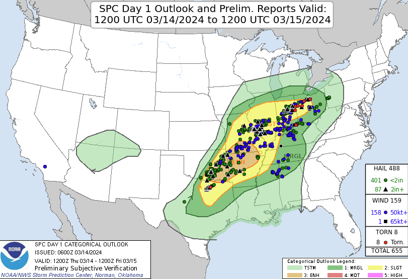 |
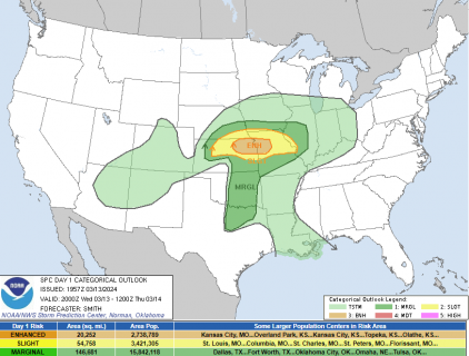
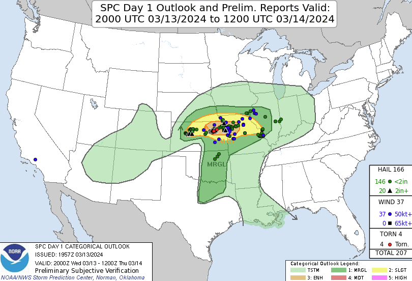
| Mar 13, 2024 SPC Categorial Outlook (20Z) | Mar 13, 2024 SPC Categorial Outlook & Preliminary Verification (20Z) | Mar 14, 2024 SPC Categorial Outlook (12Z) | Mar 14, 2024 SPC Categorial Outlook & Preliminary Verification (12Z) |
Summaries from other NWS Offices
 |
Media use of NWS Web News Stories is encouraged! Please acknowledge the NWS as the source of any news information accessed from this site. |
|

