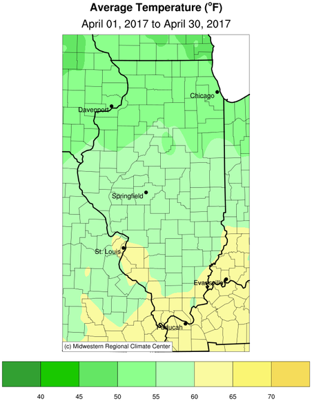
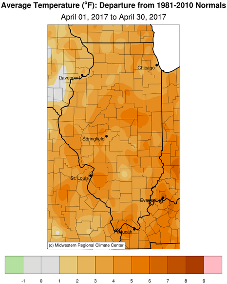
Temperature highlights:
- April 2017 continued the trend of above normal temperatures across the region, although they were not as abnormally warmer than normal as they were in February. However, average temperatures were generally 3 to 6 degrees above normal over central and southeast Illinois.
- There were only a few cool spells during the month with below normal temperatures. This included Apr 5-7th with some areas getting down near freezing on Friday morning April 7th. Also cool spells of weather were observed from April 21-23rd and during the wet and stormy end of the month from April 27-30th. The warmest spells of weather with highs in the upper 70s to mid 80s occurred from April 13-15th, the 18-20th and 24-25th.
- Peoria tied for the 8th warmest April on record with an average monthly temperature of 56.9F which was 4.6F above normal.
- Springfield had the 9th warmest April on record with an average monthly temperature of 59.2F which was 5.7F above normal.
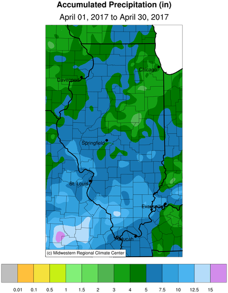
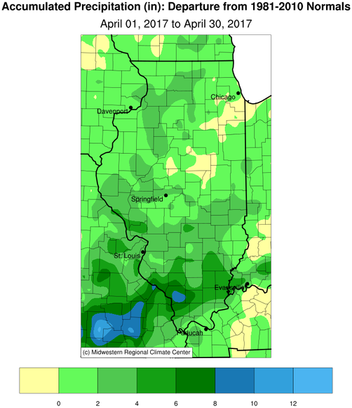
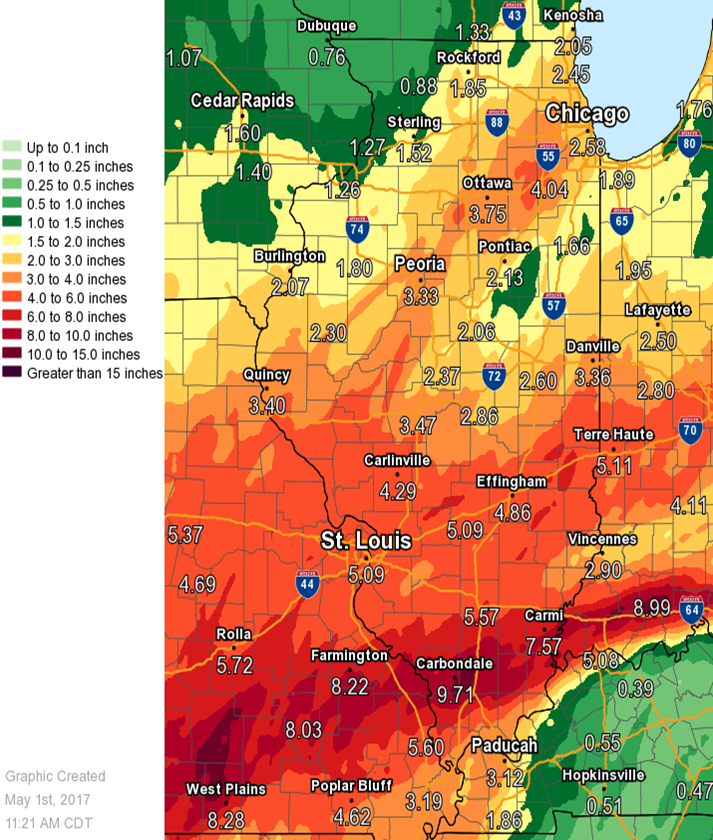
Precipitation highlights:
- Central Illinois averaged above normal rainfall, generally in the 4 to 8 inch range, with the brunt of this rainfall occurring on Wednesday April 5th and from April 26-30th.
- Very heavy rains of 3.5 to 5 inches fell across over the IL river valley and also from I-72 south, over the southern half of Illinois during the weekend of Apr 28-30th with 5-10 inches of rain south of highway 50 in southern IL and into southern parts of Missouri and Indiana.
- Peoria had the 7th wettest April on record with 8.18 inches of rainfall, which was 4.55 inches above normal.
Severe weather highlights:
- Central and Southeast IL had 6 to 10 days in April with thunderstorms, and several of those days had severe thunderstorms. Some of the bigger severe weather events occurred on Monday April 10th and from April 26-29th especially from I-72 south. Most of the severe weather was from damaging wind gusts and large hail. Canton in Fulton county had 2.5 inch diameter hail Monday afternoon April 10th. However, a few tornadoes also occurred on April 28-29th in Morgan, Richland and Lawrence counties.
| City |
County |
Rainfall |
| Ste. Marie |
Jasper |
6.85 |
| Martinsville |
Clark |
6.27 |
| Neoga |
Cumberland |
6.17 |
| Watson |
Effingham |
5.42 |
| Charleston |
Coles |
5.25 |
| Robinson 3W |
Crawford |
4.90 |
| Shelbyville |
Shelby |
4.83 |
| Jacksonville |
Morgan |
4.77 |
| Auburn 2SE |
Sangamon |
4.54 |
| Virginia |
Cass |
4.52 |
| Lake Jacksonville 1S |
Morgan |
4.32 |
| Murrayville |
Morgan |
4.20 |
| Germantown Hills 2N |
Woodford |
4.17 |
| Effingham |
Effingham |
4.03 |
| Henry |
Marshall |
4.01 |
| Chatham |
Sangamon |
3.90 |
| Taylorville |
Christian |
3.89 |
| Mattoon |
Coles |
3.76 |
| Astoria |
Fulton |
3.75 |
| Bryant |
Fulton |
3.73 |
| Olney 2S |
Richland |
3.69 |
| Springfield |
Sangamon |
3.68 |
| Mattoon |
Coles |
3.63 |
| Eureka |
Woodford |
3.59 |
| Beardstown |
Cass |
3.57 |
| Tuscola |
Douglas |
3.51 |
| Springfield 5W |
Sangamon |
3.51 |
| Springfield (COOP) |
Sangamon |
3.43 |
| Morton |
Tazewell |
3.33 |
| Sullivan |
Moultrie |
3.19 |
| Homer 2N |
Champaign |
3.14 |
| Mackinaw 1N |
Tazewell |
3.03 |
| Bismarck 3W |
Vermilion |
3.02 |
| Ogden |
Champaign |
2.91 |
| Harristown 1NW |
Macon |
2.90 |
| Peoria |
Peoria |
2.90 |
| Champaign |
Champaign |
2.86 |
| Lovington |
Moultrie |
2.77 |
| Hopewell |
Marshall |
2.66 |
| Cisco 2NE |
Piatt |
2.62 |
| Sumner |
Lawrence |
2.57 |
| Mt. Pulaski 5SW |
Logan |
2.54 |
| Danville |
Vermilion |
2.52 |
| Pekin |
Tazewell |
2.46 |
| Petersburg 8E |
Menard |
2.23 |
| Normal |
McLean |
2.00 |
| Knoxville |
Knox |
1.77 |
| Wataga |
Knox |
1.58 |
| Gilson |
Knox |
1.30 |
Precipitation, Snowfall and Temperature Maps:
Climatological Statistics for April:
The following links are to the monthly climate summaries for area cities. Only the summaries for Peoria, Springfield, and Lincoln are considered "official", meaning they are the station of record for their respective locations. The other summaries are "supplemental", meaning another location in the area is the official climate station for the city.
Climate data for other cities is available at https://www.weather.gov/climate/xmacis.php?wfo=ilx