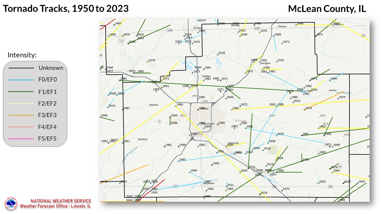
National Weather Service United States Department of Commerce


McLean County tornadoes since 1950


114 TORNADOES were reported in McLean County, Illinois between 01/01/1950 and 12/31/2022.

Click on Location or County to display Details.

Mag:
Dth:
Inj:
PrD:
CrD:
Magnitude
Deaths
Injuries
Property Damage
Crop Damage
 
Location or County Date Time (CST) Mag Dth Inj PrD CrD
Colfax 03/27/1950 04:30 PM F2 0 0 3K 0
2 Stanford 11/13/1951 01:40 PM F2 0 0 N/A 0
Downs 07/05/1953 09:00 PM F0 0 0 0K 0
Lexington 03/06/1956 04:45 PM F2 0 0 25K 0
Le Roy 04/26/1957 02:00 PM F1 0 0 25K 0
Heyworth 05/25/1960 03:00 PM F1 0 0 3K 0
Heyworth 06/01/1960 08:00 PM UNK 0 0 0K 0
Bloomington 06/04/1960 11:37 PM F2 0 0 250K 0
Bellflower 06/05/1960 12:17 AM F2 0 0 25K 0
10 Arrowsmith 03/04/1961 04:30 PM F1 0 1 250K 0
11 Saybrook 09/14/1965 04:15 PM F2 0 0 250K 0
12 Heyworth 11/12/1965 05:27 PM F2 0 0 25K 0
13 MCLEAN 04/30/1970 12:30 PM UNK  0 0 250K 0
14 Lexington 06/16/1970 05:00 PM F2 0 0 25K 0
15 Colfax 06/16/1970 05:40 PM UNK  0 0 0K 0
16 Lake Bloomington 05/24/1971 02:25 PM F1 0 0 0K 0
17 Towanda 11/01/1971 10:45 PM F1 0 0 25K 0
18 Lexington 03/31/1973 03:19 PM F1 0 0 3K 0
19 Lexington 03/31/1973 04:55 PM F0 0 0 0K 0
20 Saybrook 06/02/1973 03:50 PM F1 0 0 0K 0
21 Le Roy 06/12/1973 08:00 PM F1 0 0 25K 0
22 Carlock 04/03/1974 01:07 PM F0 0 0 0K 0
23 Mc Lean 04/03/1974 01:15 PM F1 0 0 N/A N/A
24 Colfax 04/03/1974 01:30 PM F3 0 0 250K 0
25 Anchor 06/20/1974 06:53 PM F0 0 0 0K 0
26 Hudson 04/18/1975 04:13 PM F0 0 0 0K 0
27 Ellsworth 04/30/1975 02:17 PM F0 0 0 0K 0
28 Carlock 05/30/1975 02:40 PM F2 0 0 25K 0
29 Lexington 06/29/1976 03:36 PM F2 0 0 25K 0
30 Chenoa 07/28/1976 02:55 PM F2 0 0 25K 0
31 Mc Lean 07/28/1976 03:35 PM F0 0 0 0K 0
32 Mc Lean 05/05/1977 07:22 PM F4 0 0 N/A N/A
33 Towanda 07/18/1977 11:00 AM F1 0 0 250K 0
34 Colfax 04/08/1980 01:21 AM F0 0 0 0K 0
35 Normal 05/12/1980 10:15 PM F1 0 0 25K 0
36 Bloomington 05/24/1980 12:30 PM F0 0 0 3K 0
37 Lexington 04/13/1981 08:30 PM F2 0 0 2.5M 0
38 Normal 04/13/1981 10:35 PM F0 0 0 0K 0
39 Lexington 04/13/1981 11:15 PM F1 0 0 25K 0
40 Bloomington 04/13/1981 11:20 PM F1 0 0 25K 0
41 Shirley 06/20/1981 05:45 PM F1 0 0 25K 0
42 Meadows 06/20/1981 05:45 PM F1 0 0 25K 0
43 Hudson 06/20/1981 07:34 PM F0 0 0 0K 0
44 Towanda 06/20/1981 07:34 PM F0 0 0 0K 0
45 Bloomington 06/21/1981 08:33 PM F0 0 0 0K 0
46 Holder 06/21/1981 09:16 PM F0 0 0 0K 0
47 Colfax 05/26/1982 03:27 PM F0 0 0 0K 0
48 Colfax 05/26/1982 03:27 PM F0 0 0 0K 0
49 Pleasant Hill 08/04/1982 04:55 PM F0 0 0 250K 0
50 Cooksville 08/24/1982 01:25 PM F2 0 0 2.5M 0
51 Shirley 08/24/1982 01:30 PM F0 0 0 0K 0
52 Arrowsmith 08/24/1982 01:35 PM F0 0 0 N/A 0
53 Heyworth 08/24/1982 01:35 PM F0 0 0 250K 0
54 Heyworth 06/29/1983 01:55 PM F0 0 0 0K 0
55 Holder 11/19/1985 02:50 PM F0 0 0 0K 0
56 Cooksville 11/19/1985 03:40 PM F1 0 0 25K 0
57 Lexington 09/29/1986 04:34 PM F2 0 0 2.5M 0
58 Heyworth 06/02/1987 01:13 PM F0 0 0 0K 0
59 Bloomington 06/13/1990 08:03 PM F1 0 0 N/A 0
60 Hudson 04/29/1991 07:00 PM F1 0 0 0K 0
61 Carlock 10/04/1991 05:34 PM F1 0 0 0K 0
62 McLean 12/08/1991 03:13 PM F0 0 0 250K 0
63 Cooksville 05/04/1992 03:42 PM F0 0 0 0K 0
64 Lexington 05/04/1992 03:50 PM F0 0 0 0K 0
65 Towanda 08/26/1992 02:33 PM F0 0 0 0K N/A 
66 Gridley 09/09/1992 04:46 PM F0 0 0 0K 0
67 Le Roy 05/09/1995 06:10 PM F1 0 0 150K 0
68 Saybrook 05/09/1995 07:07 PM F0 0 0 0 0
69 Saybrook 05/09/1995 07:17 PM F1 0 0 106K 0
70 Carlock 05/13/1995 06:15 PM F0 0 0 150K 0
71 Sabina 05/13/1995 08:15 PM F1 0 0 518K 0
72 Mc Lean 04/19/1996 06:09 PM F3 0 0 1.0M 0
73 Downs 04/30/1997 03:05 PM F0 0 0 100K 0
74 Ellsworth 04/29/1998 03:58 PM F0 0 0 35K 0
75 Carlock 06/04/1999 03:50 PM F0 0 0 0 0
76 Bloomington 06/04/1999 03:56 PM F0 0 0 0 0
77 Heyworth 06/04/1999 04:04 PM F0 0 0 0 0
78 Lexington 06/04/1999 04:10 PM F0 0 0 0 0
79 Chenoa 06/04/1999 04:13 PM F0 0 0 0 0
80 Saybrook 06/04/1999 04:35 PM F0 0 0 0 0
81 Anchor 06/04/1999 04:38 PM F0 0 0 0 0
82 Shamrock 05/08/2000 10:14 PM F2 0 4 175K 0
83 Le Roy 05/18/2000 06:13 PM F0 0 0 0 0
84 Le Roy 05/18/2000 06:25 PM F0 0 0 0 0
85 Twin Grove 08/23/2000 05:23 PM F1 0 0 7K 0
86 Gridley 05/08/2002 11:37 PM F0 0 0 0 0
87 Mc Lean 04/04/2003 03:20 PM F0 0 0 0 0
88 Le Roy 05/14/2003 05:08 PM F0 0 0 0 0
89 Kumler 06/13/2003 05:00 PM F0 0 0 0 0
90 Bloomington 05/18/2004 05:26 PM F0 0 0 0 0
91 Gridley 05/23/2004 07:20 PM F2 0 0 N/A  0
92 Normal 07/13/2004 01:52 PM F0 0 0 0 0
93 Towanda 04/02/2006 06:08 PM F0 0 0 0 0
94 Hudson 04/02/2006 06:12 PM F0 0 0 0 0
95 Arrowsmith 04/02/2006 06:13 PM F1 0 0 N/A  0
96 Gridley 04/02/2006 06:22 PM F0 0 0 0 0
97 Danvers 06/02/2006 01:20 PM F0 0 0 0 0
98 Mc Lean 03/28/2007 02:19 PM F0 0 0 0 0
99 Woodruff 06/04/2008 07:30 PM EF0 0 0 0 0
100 Colfax 06/15/2008 03:08 PM EF0 0 0 50K 0
101 Holder 08/19/2009 03:27 PM EF0 0 0 0 4K
102 Heyworth 05/25/2011 05:06 PM EF0 0 0 8K 0
103 Downs 05/25/2011 05:09 PM EF1 0 0 10K 0
104 Le Roy 05/28/2014 11:47 AM EF0 0 0 0 0
105 Gridley 06/21/2018 02:02 PM EF0 0 0 0 0
106 Le Roy 12/01/2018 07:06 PM EF1 0 0 75K 0
107 Le Roy 12/01/2018 07:18 PM EF2 0 0 75K 0
108 Elllsworth 12/01/2018 07:21 PM EF0 0 0 30K 0
109 Colfax 12/01/2018 07:42 PM EF1 0 0 110K 0
110 Bellflower 06/15/2019 10:36 PM EF1 0 0 40K 0
111 Gridley 07/15/2020 03:04 PM EFU 0 0 0 0
112 Downs 06/25/2021 07:26 PM EF0 0 0 0 N/A
113 Colfax 04/30/2022 05:46 PM EFU 0 0 0 0
114 Le Roy 09/18/2022 11:28 PM EF0 0 0 N/A N/A
TOTALS: 0 5 20.33M 4K


Details:

  1. 3/27/1950:  Touched down just east of Colfax, and moved northeast for about 3 miles.  One farm lost several outbuildings.
  2. 11/13/1951:  Took an intermittent path from near Mason City (Mason County), northeast across northwest Logan and southeast Tazewell Counties, into McLean County before ending near Hudson.
  3. 7/5/1953:  Reported near Downs, but was mainly aloft during its lifetime.
  4. 3/6/1956:  This tornado moved across Lexington, causing extensive roof damage to homes and businesses.  The tornado was on the ground for  3 miles.
  5. 4/26/1957:  Touched down near Le Roy, and took an intermittent path eastward to Gibson City (Ford County).
  6. 5/25/1960:  Caused minor damage to a farm 2 miles north of Heyworth.
  7. 6/1/1960:  Brief touchdown near Heyworth.
  8. 6/4/1960:  This tornado took an intermittent path, from Bloomington/Normal southeast into De Witt and Champaign Counties.  A truck terminal in Bloomington was demolished.
  9. 6/5/1960:  Touched down near Bellflower, and took an intermittent path eastward into Champaign County.
  10. 3/4/1961:  Touched down near Arrowsmith, then moved east through Saybrook before entering Ford County.  Six farmsteads were damaged at Arrowsmith, and several others at Saybrook.
  11. 9/14/1965:  Touched down just northwest of Saybrook, and moved east into Ford County, where it did most of its damage.
  12. 11/12/1965:  Brief touchdown 4 miles east-southeast of Heyworth.
  13. 4/30/1970:  Brief, intermittent touchdowns between Le Roy and Farmer City, causing extensive damage to a lumberyard.
  14. 6/16/1970:  Traveled from 2.5 miles southwest of Lexington, to 1 mile northeast of town.  Damage path was 3 blocks wide through town.
  15. 6/16/1970:  Touched down 3 miles northeast of Colfax, and slowly moved northeast for 3 miles.  Major damage to trees and minor damage to buildings was reported.
  16. 5/24/1971:  This tornado was on the ground for 2 miles and moved across a portion of Lake Bloomington, but little building damage was reported, although there was major tree damage.
  17. 11/1/1971:  Touched down 1.5 miles west of Towanda, and was on the ground for 1.5 miles.  It damaged a house and 3 garages as it traveled east-northeast.
  18. 3/31/1973:  Brief touchdown 10 miles southwest of Lexington, knocking down several telephone poles.
  19. 3/31/1973:  Brief touchdown 5 miles northeast of Lexington.
  20. 6/2/1973:  Brief touchdown near Saybrook.
  21. 6/12/1973:  First touched down 8 miles northwest of Le Roy, and moved along an intermittent path southeast until reaching town.  Several homes and two businesses were severely damage.
  22. 4/3/1974:  This was part of the "Super Outbreak" of 148 tornadoes, which affected the eastern half of the U.S. in a 24-hour period.  This particular tornado touched down 5 miles east of Carlock, but caused no damage.
  23. 4/3/1974:  This was part of the "Super Outbreak" of 148 tornadoes, which affected the eastern half of the U.S. in a 24-hour period.   This tornado originally touched down near Lincoln in Logan County, then raced northeast at 70 mph into McLean County.
  24. 4/3/1974:  Also part of the "Super Outbreak", this tornado (#4 of the overall outbreak) touched down 3 miles south-southeast of Colfax, and tracked for 8 miles to 3 miles east of Anchor.  Eight farms lost buildings, and two homes were destroyed; debris was carried for 10 miles.
  25. 6/20/1974:  Brief touchdown near Anchor.
  26. 4/18/1975:  Touched down as a waterspout over Evergreen Lake northwest of Hudson.  It moved east and dissipated as it moved onshore; the parent thunderstorm deposited 5 inches of rain immediately downstream due to the water being drawn into the storm.
  27. 4/30/1975:  Brief touchdown near the junction of highways 9 and 165 northwest of Ellsworth.
  28. 5/30/1975:  Touched down just north of Carlock, and moved northeast along the McLean/Woodford County line.  It destroyed a mobile home and a garage.  The tornado was aloft for about a 2.5 mile stretch of the overall 4.5 mile track.
  29. 6/29/1976:  This tornado struck 4 miles east of Lexington, destroying a barn and two outbuildings.
  30. 7/28/1976:  Brief touchdown 4 miles west of Chenoa, damaging two homes and destroying a garage.
  31. 7/28/1976:  Brief touchdown near Mc Lean, causing some crop damage.
  32. 5/5/1977:  This violent tornado touched down near Atlanta in Logan County, then moved northeastward for 10 miles, roughly paralleling the east side of I-55.  The tornado lifted near Funks Grove.
  33. 7/18/1977:  Touched down 1 mile north of Towanda, causing some damage at a farm.  It moved southeast for 2.5 miles, causing further damage at a cemetery and another farm.
  34. 4/8/1980:  Brief touchdown just west of Colfax, damaging some trees.
  35. 5/12/1980:  This tornado took a 1.2 mile path through the northeast section of Normal, causing significant damage to roofs and porches.
  36. 5/24/1980:  Brief touchdown near the General Electric plant on the west side of Bloomington, causing minor damage to a farm.
  37. 4/13/1981:  Touched down 4 miles southeast of Lexington, and moved southeast for 2 miles.  It destroyed several outbuildings, two cars, and 7 pieces of farm machinery.
  38. 4/13/1981:  Touched down just northeast of Normal and was on the ground for 2 miles, but caused no damage.
  39. 4/13/1981:  This thunderstorm produced 3 separate tornado touchdowns; one in southeast Woodford County northwest of Carlock, one 4 miles south of Lexington, and one in Colfax. 
  40. 4/13/1981:  Brief touchdown 3 miles east of Bloomington, damaging a house.
  41. 6/20/1981:  Touched down 5 miles northwest of Shirley near Covell.  It was on the ground for one mile, destroying a garage.
  42. 6/20/1981:  Touched down midway between Gridley and Chenoa near Meadows.  It uprooted 70 trees.
  43. 6/20/1981:  Brief touchdown near Hudson.
  44. 6/20/1981:  Brief touchdown 5 miles northwest of Towanda.  The parent thunderstorm for this tornado and the one in #41 produced intermittent tornado touchdowns from near Peoria to northwest of Champaign
  45. 6/21/1981:  Brief touchdown south of I-74 south of Bloomington.
  46. 6/21/1981:  Brief touchdown east of Bloomington near Holder.
  47. 5/26/1982:  Brief touchdown on the west edge of Colfax, causing no damage.
  48. 5/26/1982:  Brief touchdown on the north edge of Colfax, causing no damage.
  49. 8/4/1982:  Touched down 3 miles southeast of Lexington near Pleasant Hill, and traveled southeast for 7 miles before lifting just north of Colfax.  Only crop damage occurred.
  50. 8/24/1982:  This tornado initially touched down about 4 miles east-northeast of the Bloomington Airport, then moved through Cooksville before curving southeast and south, before finally entering Ford County.  Most of the damage occurred near Merna, toward the beginning of the 24-mile track.  Along the entire track, 5 homes and a trailer were destroyed, and 133 other homes were damaged.  At least 65 outbuildings were destroyed along the entire track, and 165 were damaged.
  51. 8/24/1982:  This tornado touched down 2 miles south of Shirley, moving southeast then northeast for an overall 12.5 mile path.  Only crop damage was reported.
  52. 8/24/1982:  Touched down east of Bloomington, and passed just north of Arrowsmith before lifting near Saybrook.  It caused crop and some building damage.
  53. 8/24/1982:  Touched down about 3 miles east of McLean near highway 136, then curved southeast before turning northeast and clipping Heyworth.  The tornado was on the ground for 11.5 miles. 
  54. 6/29/1983:  Brief touchdown 2 miles south of Heyworth.
  55. 11/19/1985:  Brief touchdown east of Bloomington near Holder.
  56. 11/19/1985:  Moved through Cooksville, overturning two mobile homes.
  57. 9/29/1986:  This tornado touched down northeast of Lexington, and moved 9 miles, crossing the Livingston County border near Weston. A large microwave tower was destroyed near Lexington, with several outbuildings damaged along the track.
  58. 6/2/1987:  Brief touchdown near Heyworth, causing no damage.
  59. 6/13/1990:  Touched down near Bloomington, causing some minor damage.
  60. 4/29/1991:  Brief touchdown just north of Hudson; although the tornado was about a city block wide, it caused no damage.
  61. 10/4/1991:  Brief touchdown in Carlock.
  62. 12/8/1991:  This late-season tornado was on the ground for 8 miles, from 1 mile south of McLean to 1 mile west of Heyworth.  It heavily damaged a small manufacturing plant, a mobile home, and several outbuildings.
  63. 5/4/1992:  Brief touchdown near Cooksville, causing no damage.
  64. 5/4/1992:  Brief touchdown near Lexington, causing no damage.
  65. 8/26/1992:  Brief touchdown in an open area near Towanda, causing no damage.
  66. 9/9/1992:  Brief touchdown near Gridley, causing no damage.
  67. 5/9/1995:  Touched down 2 miles north of Wapella (De Witt County), then moved northeast on an intermittent path until it dissipated in Le Roy, where it damaged a few homes.
  68. 5/9/1995:  Touched down 3 miles southwest of Saybrook, and lifted 2 miles northwest of Saybrook.  Numerous large trees were knocked down.
  69. 5/9/1995:  Touched down 2 miles northwest of Saybrook, and moved northeast for 3 miles.  5 homes were damaged, and several outbuildings destroyed.
  70. 5/13/1995:  Brief touchdown 1 mile southwest of Carlock, damaging two homes and 3 outbuildings.
  71. 5/13/1995:  Touched down 3 miles west of Sabina, and traveled eastward for 4 miles.  One home was destroyed, and 14 others were damaged.  Several grain bins and outbuildings were damaged or destroyed.
  72. 4/19/1996:  This tornado initially touched down in extreme northern Logan County, then moved into Tazewell County and then entered McLean County 5 miles west-north of McLean.  A church was destroyed, and 9 homes were damaged, along with numerous outbuildings.
  73. 4/30/1997:  This tornado was on the ground for approximately 15 miles, beginning just east of Downs and dissipating 3 miles northeast of Cooksville.  Many farm buildings were damaged or destroyed along the path, and a gas station in Cooksville was severely damaged.
  74. 4/29/1998:  This tornado touched down 2 miles west-southwest of Ellsworth, and took a 3 mile path, although the end of the track was intermittent.  Several trees were destroyed, damaging buildings in the process.
  75. 6/4/1999:  Brief touchdown 5 miles east of Carlock.
  76. 6/4/1999:  Brief touchdown 4 miles southwest of Bloomington.
  77. 6/4/1999:  This tornado initially touched down 4 miles northwest of Heyworth; it lifted, then touched down again 1 mile north of Heyworth.  No damage was reported.
  78. 6/4/1999:  Brief touchdown in a field 1 mile west of Lexington. 
  79. 6/4/1999:  Initially touched down 1 mile southwest of Chenoa.  The tornado lifted, then touched down again 3 miles south of Chenoa.  No damage reported.
  80. 6/4/1999:  Brief touchdown in a field 1 mile south of Saybrook.
  81. 6/4/1999:  Touched down several times along a path from 2 miles north of Anchor to 1 mile north of Cropsey.  No damage was reported.
  82. 5/8/2000:  This tornado touched down 1/2 mile north of Shamrock and was on the ground for 4 miles, dissipating 3 miles northeast of Downs.  A house sustained major damage northwest of Downs, where 4 people were injured.  Other outbuildings along the track sustained some damage.
  83. 5/18/2000:  Brief touchdown in a field 4 miles west of Le Roy.
  84. 5/18/2000:  Brief touchdown in a field 1 mile west of Le Roy.
  85. 8/23/2000:  Touched down 1.2 miles west-southwest of Twin Grove, and traveled 1 mile.  It destroyed several trees, but only caused minor building damage.
  86. 5/8/2002:  This tornado moved in from Woodford County, 6 miles west-southwest of Gridley.  It caused some damage to a farm in McLean County, with other damage further west in Woodford County.
  87. 4/4/2003:  Brief touchdown in a field 1 mile southwest of McLean.
  88. 5/14/2003:  Brief touchdown in a field 2 miles east of Le Roy.
  89. 6/14/2003:  Brief touchdown 1 mile northeast of Kumler, blowing the roof off a shed.
  90. 5/18/2004:  Brief touchdown on the south side of Bloomington, near the intersection of I-74 and US-51, causing no damage.
  91. 5/23/2004:  Touched down 3 miles southeast of Gridley.
  92. 7/13/2004:  Brief touchdown in a field 8 miles north of Normal.
  93. 4/2/2006:  Brief touchdown in a field 1 mile south of Towanda.
  94. 4/2/2006:  Touched down 3 miles north-northwest of Hudson, before moving into Woodford County.
  95. 4/2/2006:  Touched down 5 miles south of Arrowsmith, and was on the ground for 1 mile.  It demolished 3 concrete grain silos, and destroyed a barn.
  96. 4/2/2006:  This tornado touched down 3 miles west of Gridley, then moved northeast into Livingston County.  No damage was reported in McLean County from this tornado.
  97. 6/2/2006:  Brief touchdown in a field 5 miles southeast of Danvers.
  98. 3/28/2007:  Brief touchdown in a field 2 miles southwest of Mc Lean.
  99. 6/4/2008:  This tornado moved in from Tazewell County, and was on the ground for 4 miles, but only moved across open fields.
  100. 6/15/2008:  Touched down in an open field, and moved across Colfax, causing roof damage to several homes and trees.
  101. 8/19/2009:  Touched down in an open field 3 miles south of Holder.  Crop damage was the main result.  The tornado dissipated on the edge of a wind farm.
  102. 5/25/2011:  Touched down 4 miles east of Heyworth, causing minor damage.
  103. 5/25/2011:  Touched down 2 miles southeast of Downs, overturning a semi on I-74.  It was on the ground for 10 miles, but otherwise remained in open fields.
  104. 5/28/2014:  A landspout tornado touched down 1.1 miles north-northeast of Le Roy, remaining in open fields before dissipating 3 minutes later.
  105. 6/21/2018:  Brief touchdown in an open field 5 miles southwest of Gridley.
  106. 12/1/2018:  This tornado was part of a historic late-season tornado outbreak. It touched down about 4.4 miles south of Le Roy, and was on the ground for 1 minute. Click here for more details. 
  107. 12/1/2018: Touched down 1 mile south of Moraine View State Park, tearing the roof off a house and destroying an attached garage. Click here for more details.
  108. 12/1/2018:  Touched down 3.8 miles southwest of Ellsworth, damaging a large outbuilding. Click here for more details.
  109. 12/1/2018:  Touched down 3 miles west of Colfax, destroying several outbuildings. Click here for more details.
  110. 6/15/2019:  Touched down 1.3 miles north of Bellflower, and was on the ground for nearly 2 miles. A machine shed was destroyed.
  111. 7/15/2020:  Touched down 1.6 miles southeast of Gridley, but caused no damage.
  112. 6/25/2021:  Touched down 3.3 miles west of Downs, damaging trees and a corn field.
  113. 4/30/2022:  Touched down in an open field 3 miles southwest of Colfax, causing no damage.
  114. 9/18/2022:  Touched down on the southwest side of LeRoy and moved southeast. Click here for more details.