January 6-7, 2010
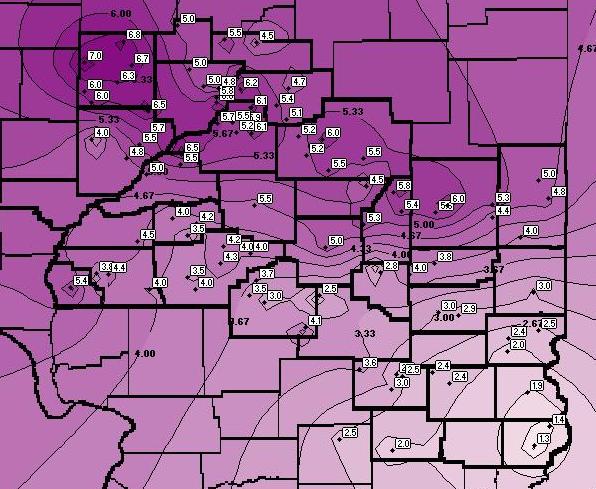
A strong upper-level wave tracked across central Illinois on January 6th and 7th, producing a period of moderate to heavy snow. The highest accumulations occurred along and north of the I-74 corridor, where 5 to 7 inch totals were common. The snowfall tapered off further south, with 3 to 5 inches along a Springfield to Charleston-Mattoon line and 1 to 3 inches south of I-70.
A cold and dry airmass was initially in place across central Illinois on January 6th, courtesy of a large ridge of Canadian high pressure. Afternoon high temperatures were generally in the teens and lower 20s, while dewpoints hovered in the single digits. As the high shifted east of the region, a vigorous upper-level disturbance dropped out of the Northern Plains and began to spread snow into west-central Illinois by the early evening hours. The atmosphere rapidly moistened, allowing the snow to spread across the remainder of the area overnight into the morning of January 7th.
The strongest lift set up across the northern half of the area, as a 150mph 300mb jet streak tracked through the Plains then eastward across south-central Illinois. As a result, snowfall rates of up to 1 inch per hour were observed from Peoria southeastward to Champaign-Urbana. Further south, synoptic lift was quite a bit weaker, which led to a lighter snowfall across south-central and southeast Illinois.
Once the system pushed further east on January 7th, an area of surface low pressure began to develop across the Ohio River Valley. The tightening pressure gradient caused by this deepening low created gusty northwesterly winds of between 15 and 25 mph. This led to considerable blowing and drifitng snow, which created hazardous driving conditions through the night of January 7th.
Below is a map of all SWOP reports collected during this storm.