January 24-25, 2026
A prolonged overrunning event occurred across a large swath of the U.S. from eastern New Mexico and Texas northeastward into New England and the Mid-Atlantic region from late evening January 23rd to the morning of January 26th. Significant snowfall was observed across the central and southern sections of Illinois...with freezing rain and sleet creating a dangerous glaze of ice further south across the Ozarks into the Tennessee River Valley.
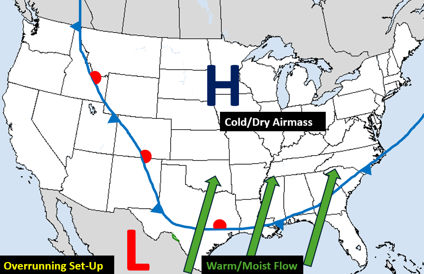
An overrunning event occurs when warm/moist air from the Gulf is forced up and over an Arctic airmass. As the air rises, it condenses into cloud cover and eventually results in precipitation. Below is a synoptic weather map depicting the set-up for this situation. A very cold airmass was in place across much of the country east of the Rockies...with strong high pressure anchored over the Upper Midwest providing a dry northeasterly flow. Meanwhile an upper-level low tracking across northern Mexico was enhancing southerly flow from the Gulf up and over the frontal boundary stalled in the Deep South.
SURFACE MAP 6AM CST JANUARY 24, 2026
As a cold front advances southward, it undercuts the existing warm airmass as shown in the diagram below. As a result, the leading edge of the cold airmass is shallow...then gets progressively thicker further north away from the front. As overrunning precipitation develops along and north of the frontal boundary, the type of precipitation that reaches the ground is determined by the thickness of the cold airmass. Where temperatures are at or above freezing throughout the entire profile, rain will be observed. As the thickness of the low-level cold airmass increases, the rain will freeze upon contact with the ground (freezing rain) or freeze into ice pellets (sleet). Once the entire depth of the atmosphere is below freezing well north of the front, snow will be the dominant precipitation type.
PRECIPITATION TYPE DIAGRAM
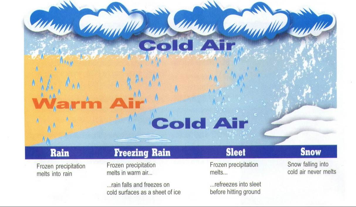
SOUTH NORTH
During the evening of January 23rd, a prominent short-wave trough was noted on water vapor imagery off the coast of Baja, California. Note the distinct swirl in the imagery. As this wave tracked eastward across northern Mexico, it would provide the necessary synoptic lift over the prevailing Arctic frontal boundary to produce the widespread wintry precipitation over the weekend.
WATER VAPOR IMAGERY CENTERED ON 6 PM CST JANUARY 23, 2026

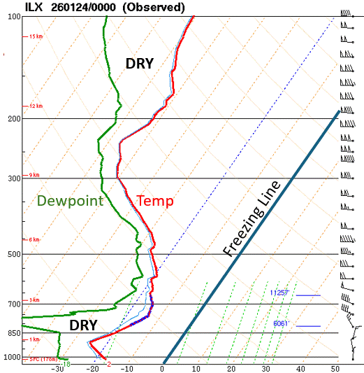
The atmosphere across central Illinois was initially very dry...as evidenced by the upper air sounding from NWS Lincoln during the evening of January 23rd. Note how far apart the red line (temperature) and green line (dewpoint) are below about 700mb. This indicates the sub-cloud layer is dry and will need to be adequately moistened before precipitation is able to reach the ground without evaporating. Also note that the entire depth of the atmosphere is well below freezing. As overrunning precipitation began to develop during the morning of Saturday, January 24th, it had to first overcome the low-level dry airmass. This delayed precipitation onset until afternoon for most locations and also limited snowfall to generally 1 inch or less through sunset Saturday.
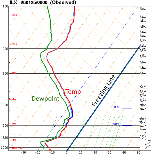
Once the profile moistened from the top-down, wintry precipitation was able to fall and accumulate more efficiently during the night of January 24th into the morning of January 25th. The image below shows the NWS Lincoln upper air sounding during the evening of January 24th. Note how the previously dry sub-cloud layer has fully saturated.
After a brief lull in the steady snow along and north of the I-72 corridor during the evening, the Baja, California wave pushed across the Deep South and enhanced the synoptic lift over the frontal boundary. This led to a round of moderate to heavy snow with significant accumulations across the southern two-thirds of the NWS Lincoln County Warning Area (CWA) overnight through about midday on January 25th.
By the time the snow tapered off and came to an end, significant amounts had been observed across parts of central and southeast Illinois...especially along and south of the I-70 corridor where amounts of 8 to 12 inches were common. Some of the highest totals were recorded across southern Richland County around Olney where a few reports indicated 13-14 inches. Amounts decreased further north, with 4-8 inches along the I-72 corridor from Jacksonville to Danville...and just 1 to 3 inches along and north of a Macomb to Peoria line. While winds did not get particularly strong, NE winds gusting 20-25mph on January 24th and N/NW winds gusting 25-30mph on January 25th created considerable drifting of the snow in places.
JANUARY 24-25, 2026 STORM TOTAL SNOWFALL


