Severe thunderstorms capable of large hail and damaging wind gusts appear possible over the central and southern High Plains and eastern Kansas into Missouri Friday afternoon and evening. Rounds of storms Friday ahead of a slow moving frontal boundary will bring locally heavy rainfall and scattered flash flooding potential to the Mid-Mississippi, Ohio, and Tennessee Valleys, and the Appalachians. Read More >
February 17, 2022
After a period of very warm conditions with high temperatures climbing well into the 50s to around 60 degrees, a strong cold front brought an abrupt end to the spring-like weather on February 17th. Rain changed to freezing rain, sleet, and snow...with significant accumulations of ice and snow occurring everywhere north of the I-70 corridor. In addition, northerly winds gusting 35-45mph created considerable blowing and drifting snow during the afternoon and evening.
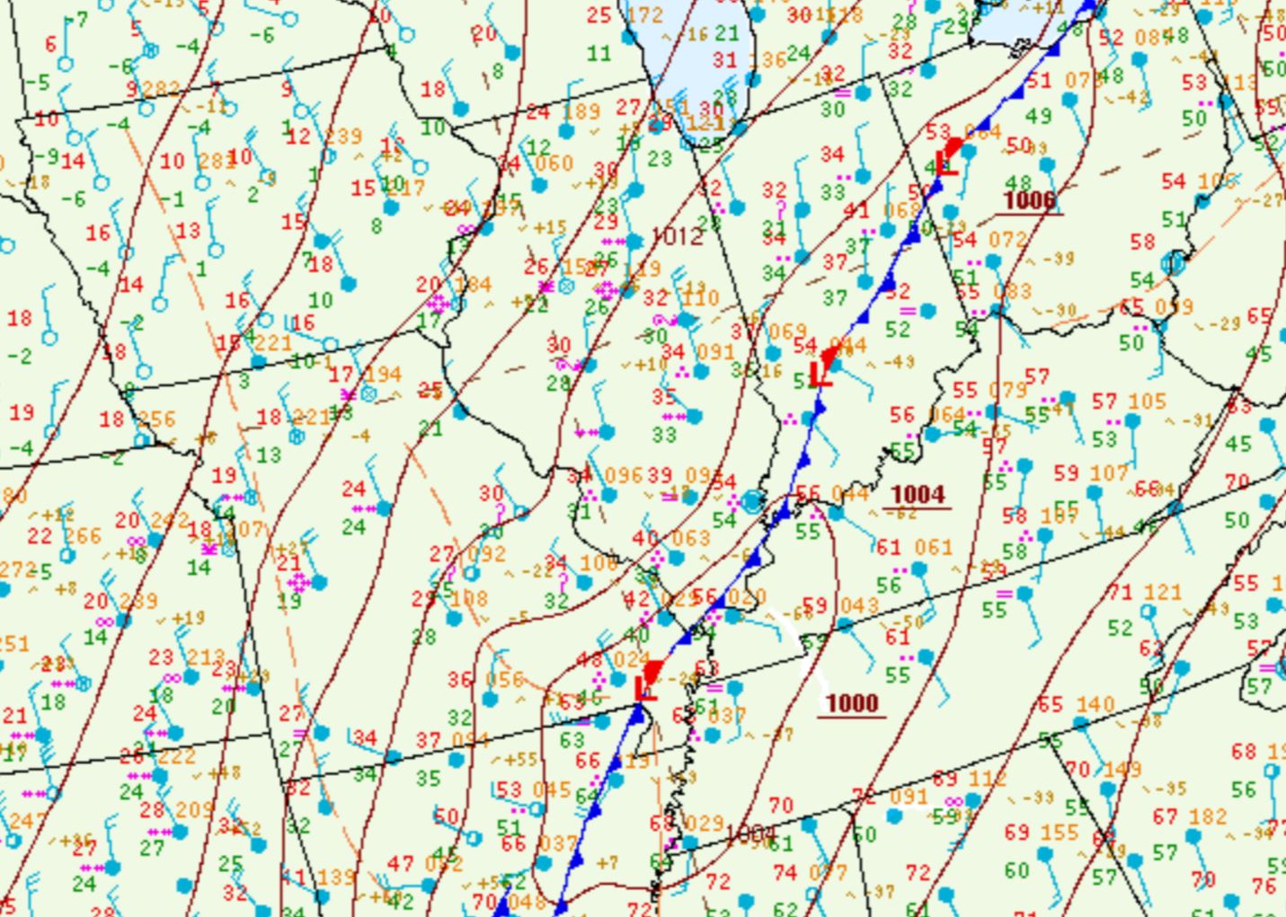
Rain showers developed ahead of an approaching cold front across the Illinois River Valley during the evening of February 16th...then spread eastward across the remainder of the region overnight. The rain became heavier and more widespread after midnight, particularly along and southeast of a Danville to Taylorville line where amounts of 1 to 3 inches were observed by the morning of February 17th. The precipitation along and behind the boundary briefly came to an end during the early morning: however, as low pressure tracked from the Ozarks northeastward toward the Ohio River Valley, it quickly returned from southwest to northeast across the area by mid to late morning. The surface weather map below from midday February 17th shows the cold front extending from central Indiana southwestward into Arkansas. Note the 1000mb low over the bootheel of Missouri, which was spreading wintry precipitation across a large chunk of the region from central and northern Missouri to the southern Great Lakes.
SURFACE WEATHER MAP 12PM CST FEB 17
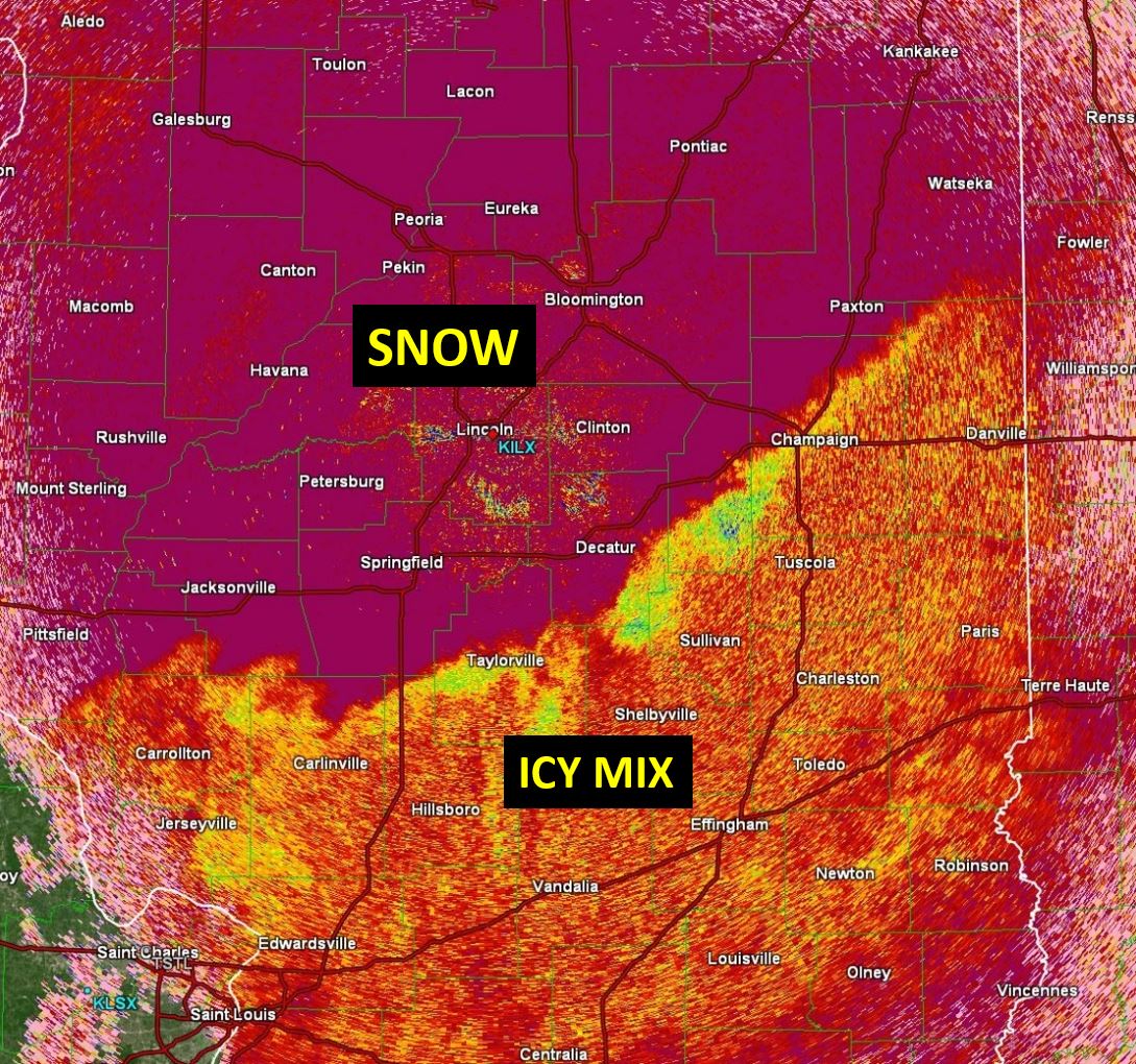
With the entire NWS Lincoln County Warning Area (CWA) on the cold side of the system, rain transitioned to freezing rain and sleet...then to snow as the day progressed. The main precipitation type across the Illinois River Valley was snow: however, a period of freezing rain and sleet occurred further east before gradually changing to heavy snow. Radar imagery from 1pm indicated a band of freezing rain and sleet (denoted by the yellow colors on the image below) from near Danville/Champaign southwestward to Shelbyville and Taylorville...with all snow falling further north (red colors).
RADAR IMAGERY 1PM CST FEB 17
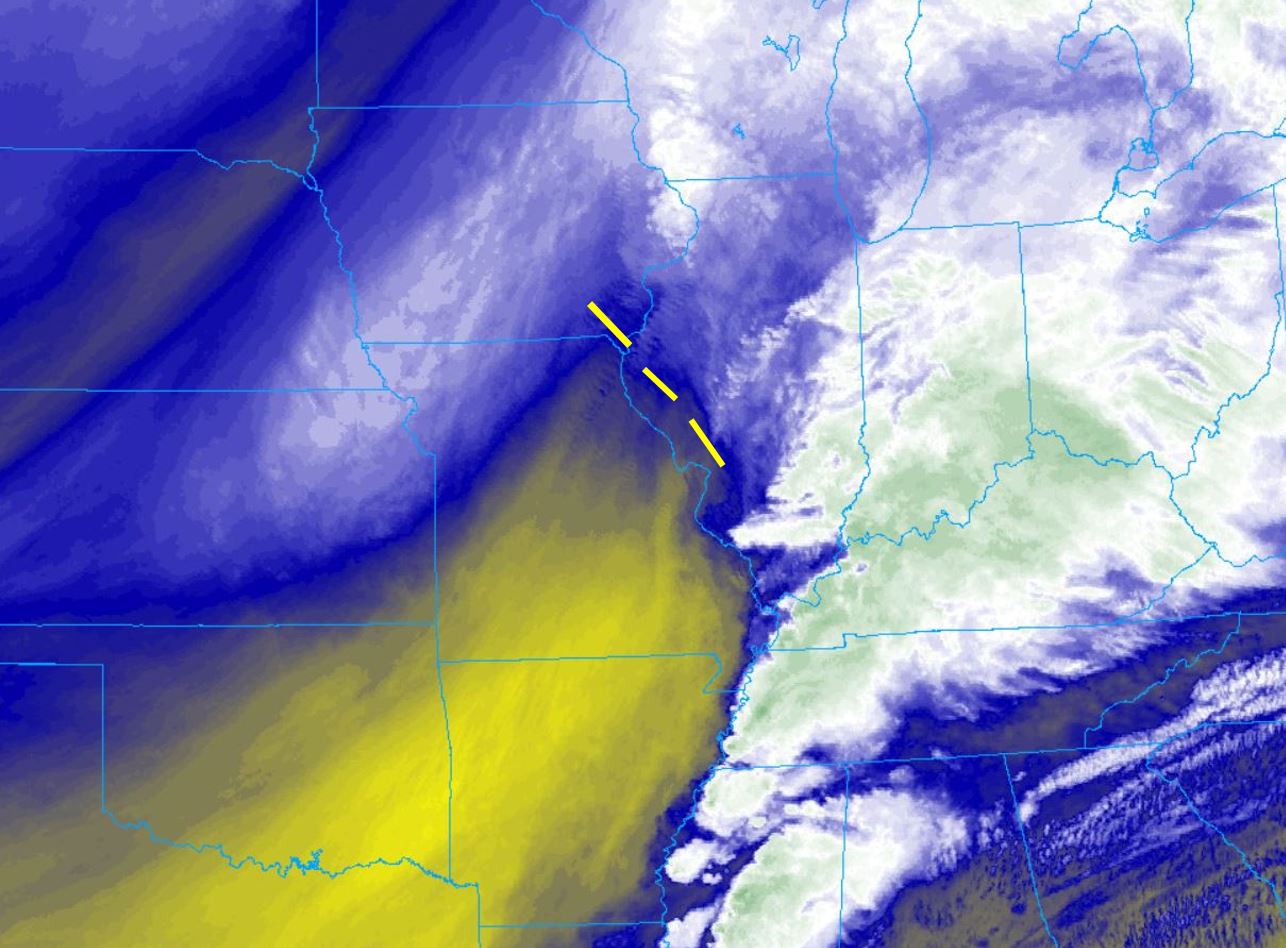
A vigorous upper-level wave approaching from the southwest created enhanced synoptic lift across central Illinois from late morning through the afternoon. The water vapor imagery below shows this feature (denoted by the dashed yellow line). Note the yellow coloring behind the wave, indicating drying (sinking motion) upstream from Texas into Missouri...while rising motion was noted ahead of the wave across central Illinois.
WATER VAPOR IMAGERY 130PM CST FEB 17
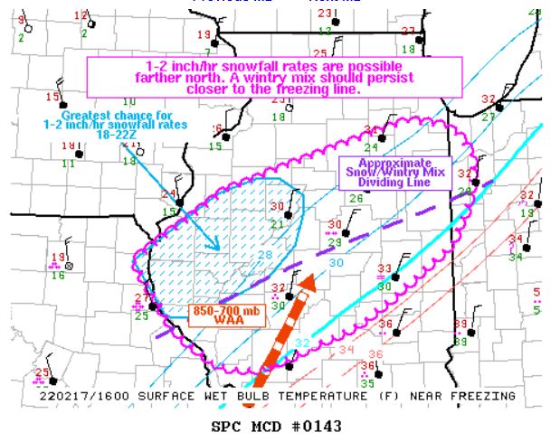
Thanks to ample deep-layer moisture flowing northward from the Gulf of America and strong lift created by the upper wave, snow became heavy across west-central Illinois by midday. In fact, snowfall rates reached 1 to 2 inches per hour as the wave approached. This prompted the Storm Prediction Center (SPC) to issue a Mesoscale Convective Discussion (MCD) for parts of central Illinois.
MESOSCALE CONVECTIVE DISCUSSION
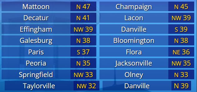
Snow began to rapidly accumulate...primarily along and north of a Quincy...to Lincoln...to Watseka line. In addition to the falling snow, strong northerly winds created near white-out conditions at times...prompting numerous road closures around the area. Further south, a mixture of freezing rain and sleet persisted, with mostly rain well south of I-70. Here is a look at some of the peak wind gusts logged at local airports.
FEB 17 PEAK WIND GUSTS (MPH)
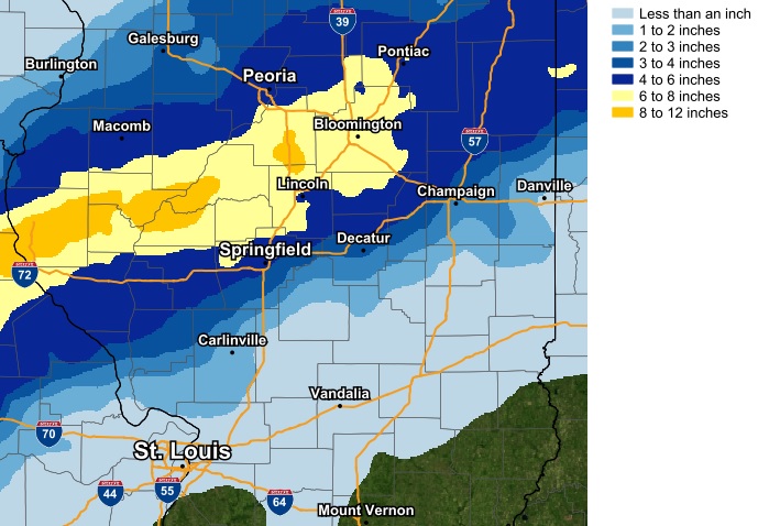
Once the upper wave passed to the northeast, synoptic subsidence in its wake led to a rapid decrease in snowfall rates from west to east across the area from late afternoon into the early evening. Despite an end to the snow, gusty winds and falling temperatures continued to create very hazardous driving conditions through the night of February 17th. Storm total snowfall was highest in a swath from Quincy northeastward to Bloomington-Normal, where amounts of 6 to 10 inches were common. Snow amounts decreased into the 1 to 3-inch range further north around Galesburg...and further south along a Carlinville to Danville line. Only trace amounts of snow were observed south of I-70.