March 3, 2023
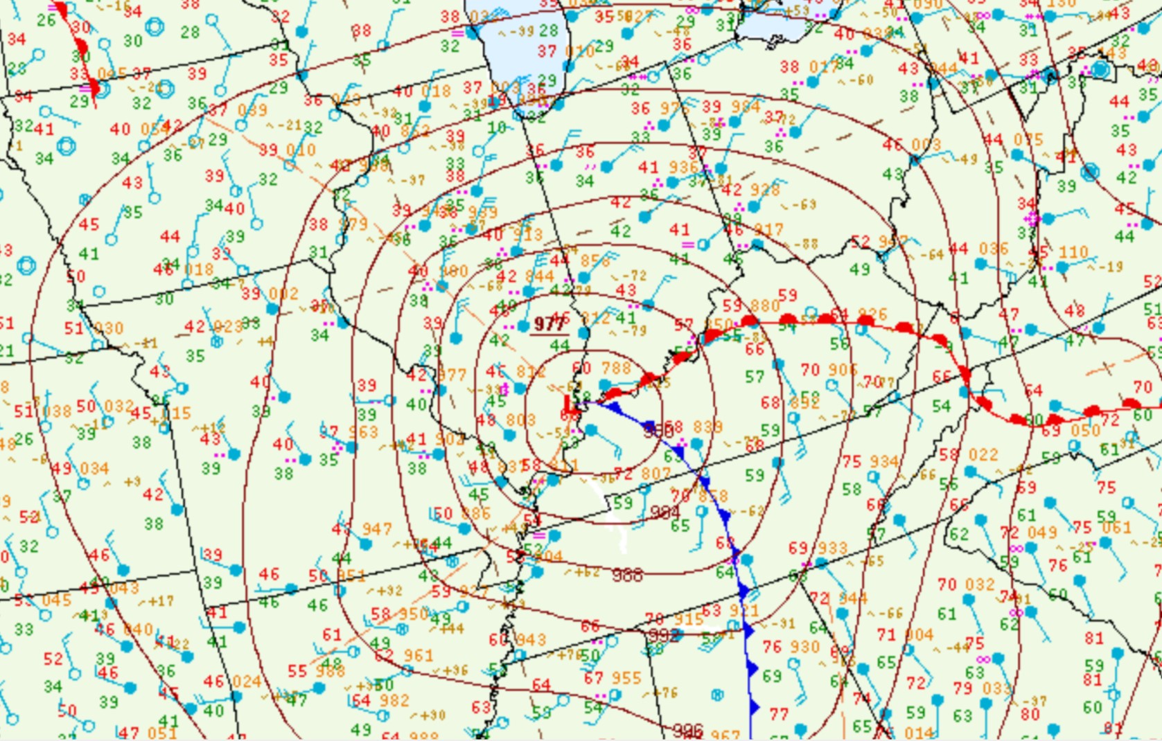
As a vigorous upper-level wave tracked eastward out of the southern Rockies, surface low pressure formed over Texas then lifted northeastward into the Ohio River Valley. Analysis from the evening of March 2nd showed a 991mb low over central Texas...with the low rapidly deepening to 976mb as it tracked into southern Indiana by the afternoon of March 3rd. Surface pressures of these magnitudes are rare across the Midwest and are in fact more comparable to a tropical storm or hurricane. As the low passed overhead, all-time record lowest barometric pressures were observed at Paducah, Kentucky (977.7mb) and Evansville, Indiana (976.0mb). The map from 12pm March 3rd below shows the 977mb low centered just north of Paducah with a warm front arcing eastward along the Ohio River. Central Illinois was on the cool side of the system as evidenced by midday temperatures ranging from the upper 30s to the middle 40s. Note the tightly packed lines of equal pressure (isobars), indicative of strong winds.
SURFACE WEATHER MAP 12PM CST MAR 3
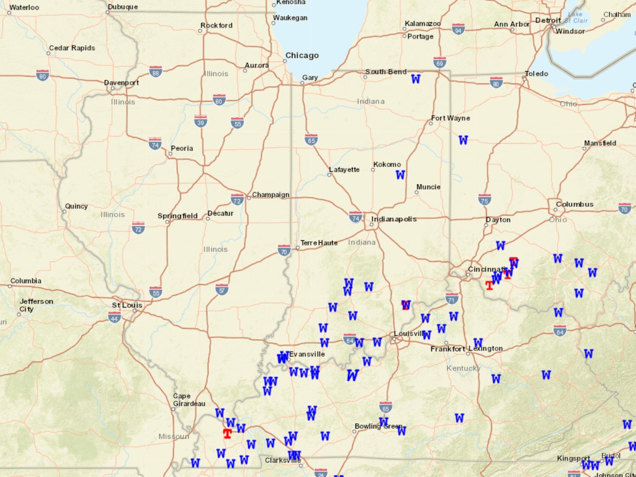
As the low continued northeastward into southern Indiana, a line of strong to severe thunderstorms brought damaging wind gusts and a couple of tornadoes to areas just southeast of the National Weather Service Lincoln County Warning Area (CWA). In fact, tornado warnings were issued as close as Gibson County, Indiana...which is less than 20 miles from our southeasternmost county of Lawrence. Note the widespread thunderstorm wind damage reports across Kentucky and the southern parts of Indiana and Ohio below.
SEVERE WEATHER REPORTS MARCH 3, 2023 (W=WIND, T=Tornado)
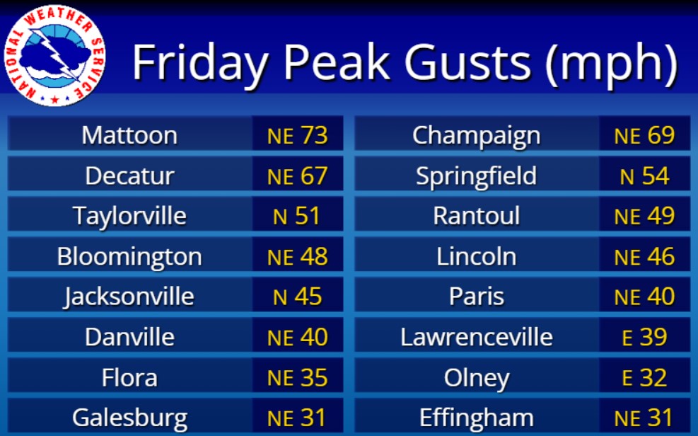
Meanwhile to the north of the low track, central Illinois was getting battered with very strong gradient winds. Northeasterly gusts frequently topped 50mph...with the highest gusts in excess of 60mph focused in a corridor from Decatur and Mattoon northeastward to Champaign. The highest gust recorded was a whopping 73mph at the Mattoon Airport!
PEAK WIND GUSTS MARCH 3, 2023
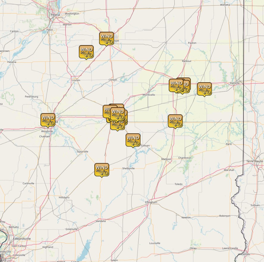
Given the high wind gusts from an unusual direction (northeast), a number of damage reports were received during the afternoon of March 3rd. Trees, tree branches, and power lines were downed in Decatur and Champaign...while a street lamp was toppled in Bloomington. Within the SWOP network, an observer near Harristown in Macon County reported part of a large tree was blown down and a large water tank was shifted several feet. Another observer in Arthur in Douglas County reported a tree down. Here is a map of all the non-thunderstorm wind damage observed.
NON-THUNDERSTORM WIND DAMGE REPORTS MARCH 3, 2023
With temperatures initially in the upper 30s and lower 40s, rain was the primary precipitation type across central Illinois. As the low continued to deepen, atmospheric lift increased...leading to dynamic cooling aloft and a change over to snow across parts of the area. The snow was first observed during the early afternoon along the I-55 corridor, then gradually spread eastward to I-57 and the Indiana border later in the afternoon. Thanks to strong upward motion and sufficient elevated instability, a few cracks of thunder were heard during the period of heavy, wet snow. Despite prolific large snowflakes coming down, the warm and wet ground conditions prevented significant accumulations. Nonetheless, amounts of 1 to 2 inches were able to accumulate before the snow band weakened and quickly shifted further eastward. Accumulations were confined to locations along a Bloomington to Springfield line northeastward to Danville. Areas along and south of I-70 remained too warm for any snow.
Rainfall with this system was heaviest along and southeast of a Robinson to Flora line where amounts of 2.50 to 3 inches were common. Rainfall steadily decreased further northwest...with less than 0.25 along and northwest of a Macomb to Henry line.
RAINFALL MARCH 3-4, 2023


