March 10-11, 2026
A significant severe weather event unfolded across Illinois from the late afternoon of March 10th into the early morning of March 11th. A total of 6 tornadoes touched down within the National Weather Service Lincoln County Warning Area (CWA)...with additional tornadoes occurring in northern and southern parts of the state.
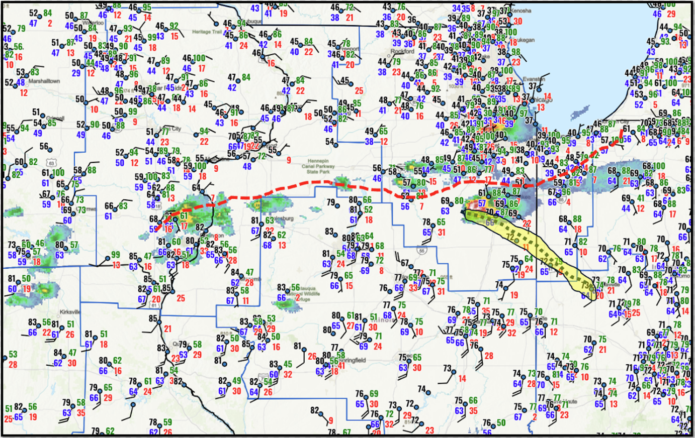
An unseasonably warm and humid airmass surged northward during the afternoon of March 10th, pushing high temperatures into the upper 70s and lower 80s across central Illinois. Record highs were established at Springfield (84 degrees), Peoria (83 degrees), and Lincoln (82 degrees)...all topping their previous highs set back in 1955. 6pm surface analysis showed a stationary front extending from southeastern Iowa to northwestern Indiana...with a sharp north-south temperature gradient across the boundary. Temperatures to the north of the front were in the 40s across much of northern Illinois and as cold as the upper 30s along the western shores of Lake Michigan. Meanwhile to the south, readings were still in the upper 70s and lower 80s in the warm sector across central Illinois. The image below shows the front (dashed red line), as well as a secondary wind shift line (circled yellow) trailing southeastward from the boundary to near Lafayette, Indiana.
SURFACE MAP 6PM CDT MARCH 10, 2026
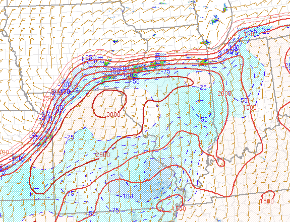
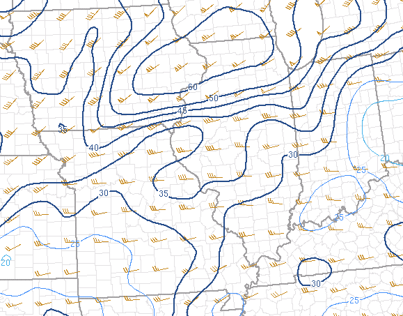
Early evening analysis from the Storm Prediction Center (SPC) indicated a highly unstable airmass in place within the warm sector...with Mixed Layer Convective Available Potential Energy (MLCAPE) of 2000-2500J/kg across much of central Illinois and as high as 3000J/kg near Quincy. Deep-layer wind shear was quite strong: however, low-level shear was maximized near and just north of the frontal boundary where 0-3km shear was analyzed at 55-65kt.
MIXED LAYER CAPE (MLCAPE) 6PM CDT MARCH 10, 2026
0-3KM SHEAR 6PM CDT MARCH 10, 2026
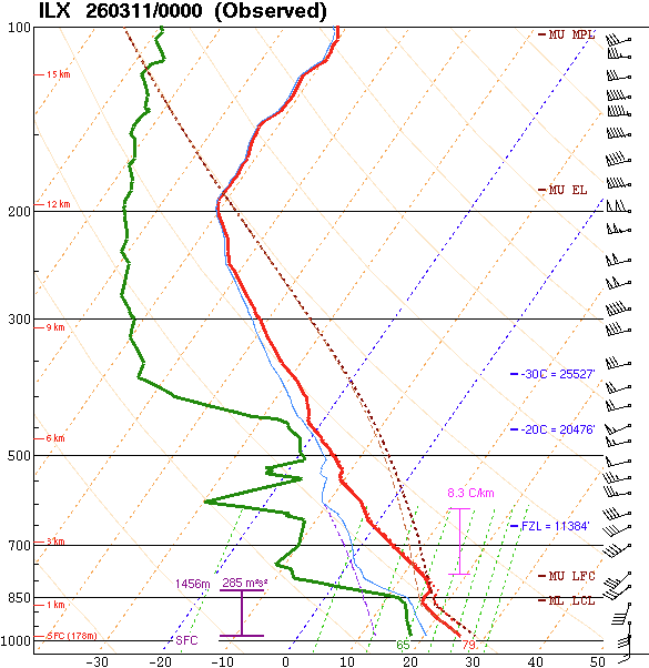
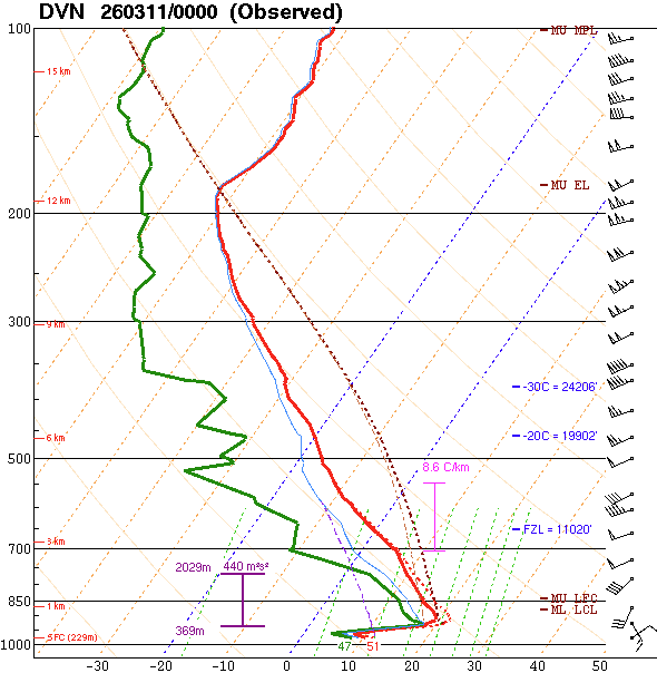
6pm balloon launches conducted by National Weather Service Lincoln (ILX) and National Weather Service Quad Cities (DVN) highlighted the significant airmass difference across the boundary. To the south of the front, the ILX sounding showed a virtually uncapped and highly unstable environment with Surface Based Convective Available Potential Energy (SBCAPE) of 2825J/kg. Meanwhile to the north, the boundary layer had cooled and stabilized at DVN courtesy of northeasterly surface winds. Despite the strong cap to surface-based convection, pronounced elevated instability was noted with Most Unstable Convective Available Potential Energy (MUCAPE) of 3223J/kg. While both sites featured strong wind shear (turning and increasing winds with height), low-level shear was greatest further north close to the boundary. As such, 0-3km shear increased from 36kt at ILX to 63kt at DVN. Given the severe weather parameters in place, it became evident the risk for tornadoes was maximized immediately along and on the southern fringe of the boundary...while the very large hail risk was focused along and north of the front.
 |
 |
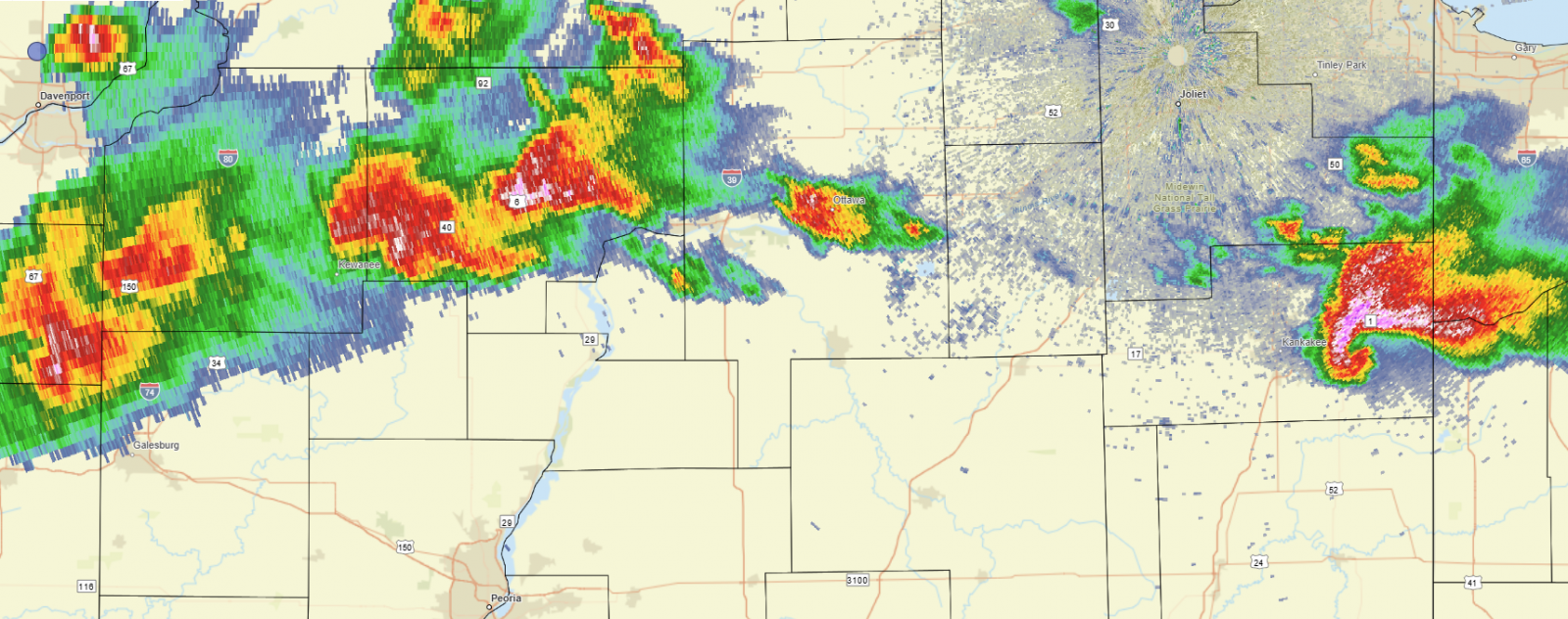
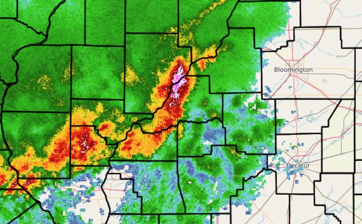
Thunderstorms were initially slow to develop due to capping in the warm sector and the lack of upper-level support. As a short-wave trough tracked across the Northern Plains into the Upper Midwest, the cap gradually weakened as the afternoon progressed and the first supercell thunderstorm rapidly developed along the McLean/Woodford County line. This storm dropped quarter-sized (1" diameter) hail in far eastern Woodford County before lifting into Livingston County and becoming significantly stronger as it curved eastward along the boundary. It dropped grapefruit-sized (4" diameter) hail north of Pontiac in Livingston County...then spawned a long-track tornado from Kankakee County into northwest Indiana. Further north, additional cells well north of the front produced giant hail ranging from 2 to 4.5" in diameter in the western suburbs of Chicago. In the 6:45pm radar imagery below, note the impressive hook echo southeast of Kankakee as the tornado was in progress.
RADAR 6:45 PM CDT MARCH 10, 2026
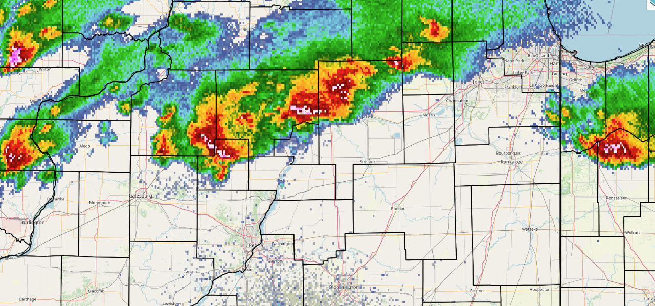
As the initial tornadic supercell tracked into Indiana, additional thunderstorms quickly formed further west along the trailing stationary front. While most of these cells skirted the National Weather Service Lincoln County Warning Area (CWA) to the north, a couple strong to severe cells tracked across northern Knox County into Stark and Marshall counties. Three tornadoes touched down across this area: an EF-1 tornado that crossed from northeastern Knox County into western Stark County, an EF-0 tornado just north of Wyoming in Stark County, and an EF-0 tornado between Lacon and Henry in Marshall County. Mainly tree damage occurred with all three storms: however, the Knox/Stark EF-1 tornado caused roof, siding, and window damage to a few homes. No injuries were reported.
RADAR 7:33 PM CDT MARCH 10, 2026
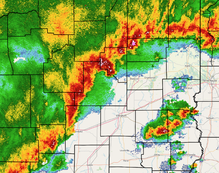
The thunderstorms impacting Stark and Marshall counties tracked east-northeastward out of the NWS Lincoln CWA by mid-evening, then the focus turned further west along an advancing cold front approaching the Mississippi River. A line of storms formed ahead of the front, then crossed the Illinois River around midnight. One of the cells produced a downburst with estimated 80-90mph winds in Havana in Mason County. The radar image below shows the intense cell near Havana at midnight. Shortly afterwards, the storms began bowing forward, creating a prominent notch within the convective line over Mason County. Two tornadoes occurred within the notch: an EF-1 tornado that touched down along US-136 just east of Havana and tracked northeastward to near Topeka...and an EF-1 tornado that tracked from south of Forest City in Mason County to south of Green Valley in Tazewell County. Several trees and power poles were snapped, a few irrigation pivots were overturned, and a horse barn was partially destroyed along the paths of the tornadoes.
RADAR 12:00 AM CDT MARCH 11, 2026
The line of thunderstorms gradually meandered further east-southeastward through the remainder of the night, producing scattered wind damage, frequent lightning, and heavy rainfall. The radar image below shows the line extending from southern Vermilion County southwestward to eastern Christian County at 4:55am CDT. A swath of wind damage was observed from Pana to near Shelbyville at around this time. The storms then dropped south of the I-70 corridor, where an EF-0 tornado destroyed a barn and caused tree damage near Yale in Jasper County. The line of storms then gradually pushed into Indiana by around 7am.
RADAR 4:55 AM CDT MARCH 11, 2026
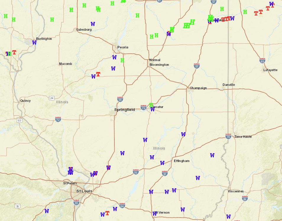
MARCH 10-11, 2026 SEVERE WEATHER REPORTS