March 15-16, 2026
A late winter storm system brought a wide variety of weather to central Illinois from the afternoon of March 15th into the morning of March 16th. Strong gradient winds, severe thunderstorms, and tornadoes occurred on the warm side of the system on the 15th...followed by sharply colder weather with accumulating snow and near blizzard conditions across parts of the area on the 16th.
Surface analysis from 4pm March 15th showed a 987mb low near Peoria with a cold front extending southward into the Ozarks. Strong southerly winds gusting 45-55mph ahead of the system had pushed temperatures well into the 60s across central Illinois, while readings behind the front had dropped into the 20s and 30s across Iowa.
SURFACE MAP 4PM CDT MARCH 15, 2026

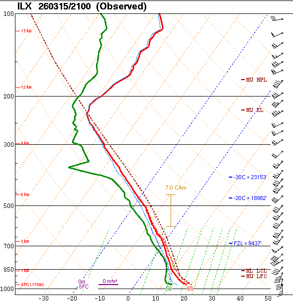
With central Illinois firmly in the warm sector of the system and an ENHANCED risk for severe weather in place, National Weather Service Lincoln opted to release a special 21z (4pm) balloon in order to sample the pre-storm environment. The resulting upper air sounding revealed modest instability (Surface Based Convective Available Potential Energy (SBCAPE) of 728J/kg), but strong deep-layer wind shear (0-6km bulk shear of 53kt). Surface winds were from the south at 15kt, but veered to the southwest and increased to 70kt at 12,000ft aloft...signaling a significant amount of wind energy in the profile.
NWS LINCOLN (ILX) UPPER AIR SOUNDING 4PM CDT MARCH 15, 2026
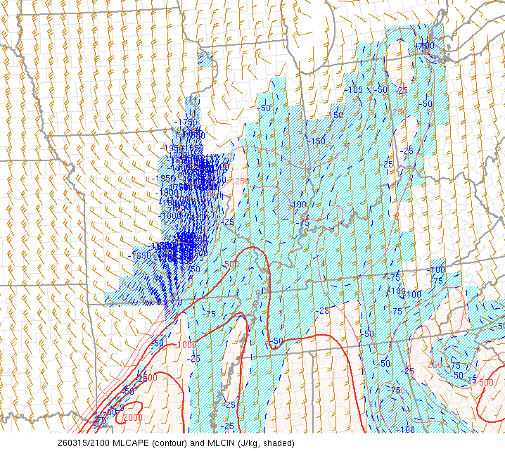
Mesoanalysis from the Storm Prediction Center (SPC) verified the weak instability across central Illinois and indicated much greater instability (Mixed Layer Convective Available Potential Energy (MLCAPE) in excess of 1000J/kg) upstream from Arkansas southward to the Gulf Coast.
MIXED LAYER CAPE (MLCAPE) 4PM CDT MARCH 15, 2026
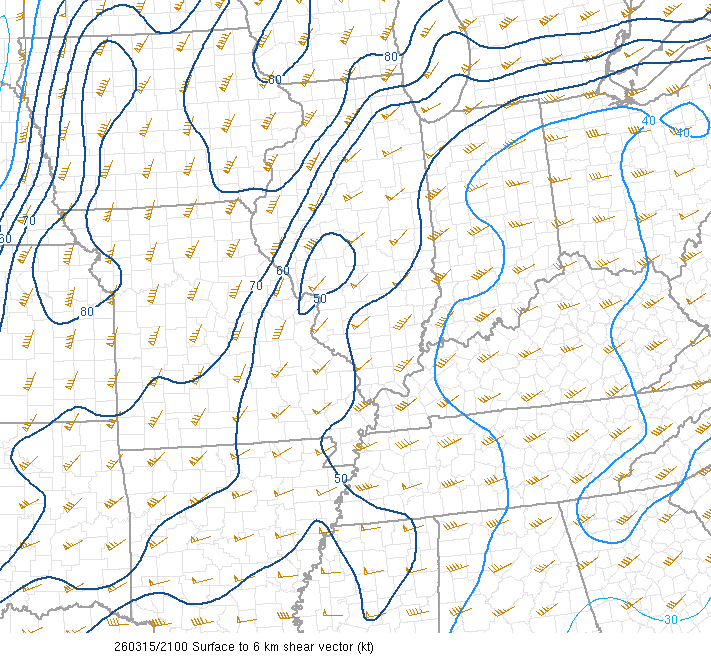
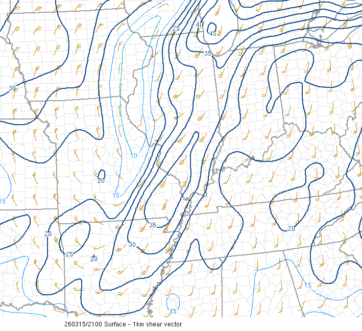
Further analysis revealed 0-6km bulk shear of 50-60kt across all of central Illinois, with higher values in excess of 70kt behind the cold front across Iowa and Missouri. Meanwhile, a narrow corridor of enhanced low-level shear was evident east of the I-55 corridor where 0-1km values ranged from 30-40kt. At this time, concern was growing that once storms developed and reached the more highly-sheared environment across east-central Illinois that an increased tornado risk would materialize.
0-6KM SHEAR 4PM CDT MARCH 15, 2026 0-1KM SHEAR 4PM CDT MARCH 15, 2026
 |
 |
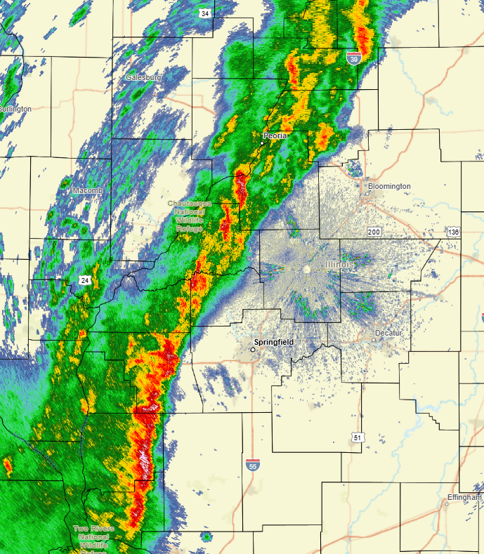
As the low tracked northeastward and pulled its trailing cold front across west-central Illinois, a broken line of thunderstorms developed by mid-afternoon. The storms were initially sub-severe in the more stable environment north of the Saint Louis area: however, one cell eventually strengthened and prompted NWS Lincoln to issue the first Severe Thunderstorm Warning for portions of Scott, Morgan, and western Sangamon counties at 4:16pm CDT. The radar image below shows a disorganized line of convection from Lacon...to Peoria...to near Petersburg...with stronger cells capable of damaging wind gusts in excess of 60mph across Morgan, Greene, and Jersey counties.
RADAR IMAGERY 4:37PM CDT MARCH 15, 2026
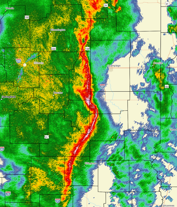
Once the storms became better organized, the line of convection advanced east-northeastward at 50-55mph for the remainder of the afternoon into the early evening. As is typically the case with a Quasi-Linear Convective System (QLCS) or "squall line," numerous kinks and notches were observed along the leading edge. These are key locations for potential tornadic development and were carefully monitored by NWS radar operators throughout the event. A number of Tornado Warnings were issued accordingly. In addition, a portion of the line began bowing forward...indicative of a powerful rear-inflow jet accelerating the storms forward and creating damaging wind gusts of greater than 70mph. In the 6:59pm radar image, note the prominent bowing segment exiting Moultrie County and pushing into western Douglas and Coles counties. Also observe the jagged nature of the entire line, signaling the potential for quick spin-up tornadoes.
RADAR IMAGERY 6:59PM CDT MARCH 15, 2026
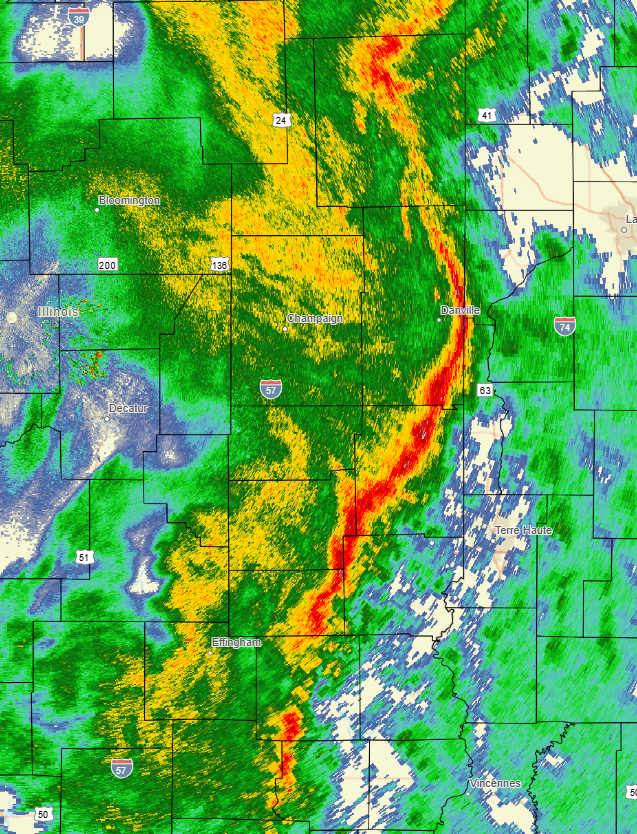
The storms continued east-northeastward across I-57 and by 7:52pm CDT the bowing segment was crossing Vermilion County toward the Indiana border. Shortly afterwards, the storms pushed entirely into Indiana by around 8:30pm CDT. Widely scattered wind damage occurred along the entire length of the line: however, the most concentrated wind damage focused along the surging part of the line from southern Christian County around Pana northeastward to near Tuscola in Douglas County. NWS storm surveys found 7 tornado touchdowns along the this path...including 4 EF-1s and 3 EF-0s.
RADAR IMAGERY 7:52PM CDT MARCH 15, 2026
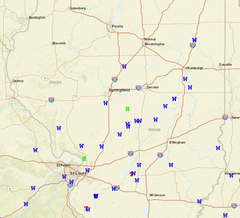
STORM REPORTS MARCH 15, 2026
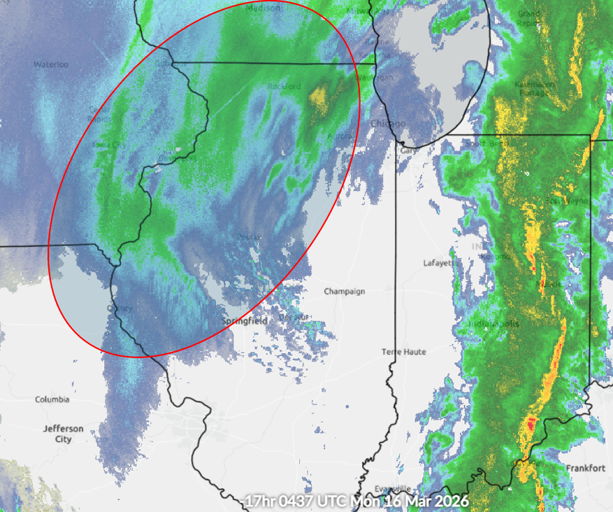
After the cold front passed and the convection swept into Indiana and Kentucky, temperatures plunged later in the evening. After highs in the 60s earlier in the day, readings ranged from the upper 20s in the Illinois River Valley to the upper 30s near the Indiana border by midnight. While the low had lifted into the Great Lakes, deformation band snow extended southwestward mainly along and west of I-55. The 11:37pm CDT regional radar mosaic shows the storms well to the east in Indiana and an area of snow (red oval) spreading across the western half of central Illinois.
RADAR IMAGERY 11:37PM CDT MARCH 15, 2026
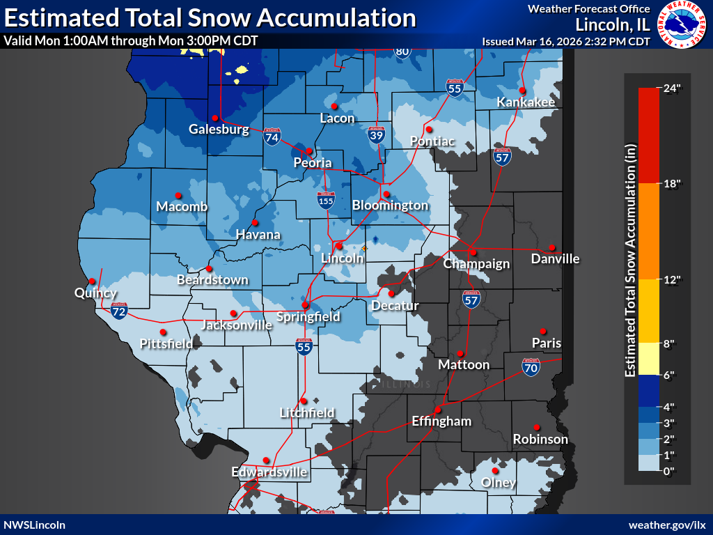
The snow continued throughout the night, then tapered off to snow showers by the morning of March 16th. Storm total snowfall was generally around 1 inch along the I-55 corridor...but increased to 2-4 inches in the Illinois River Valley. Very strong west-northwest winds gusting 40-50mph caused blowing snow, significant visibility reductions, and near blizzard conditions in open areas along and northwest of a Havana to Minonk line. The winds remained strong and gusty through the afternoon of the 16th, resulting in continued blowing and drifting snow mainly in rural locations. Numerous traffic accidents were reported and parts of I-39 in Woodford County had to be closed.
SNOWFALL MARCH 15-16, 2026