April 17, 2026
A powerful early spring storm system brought widespread severe weather to the Midwest on April 17th. Scattered supercell thunderstorms formed in the Illinois River Valley during the late afternoon...with some of the storms producing damaging wind gusts of 60-70mph and hail as large as 2 inches in diameter (hen egg-sized). After the initial convection lifted northward out of the area, a squall line advanced eastward across the Mississippi River accompanied by widespread damaging wind gusts along and north of the I-72 corridor. In addition, numerous tornadoes were embedded within the line...creating corridors of enhanced damage. After extensive storm damage surveys over the course of the next 4 days, 28 tornado touchdowns were documented across the National Weather Service Lincoln County Warning Area (CWA), breaking the previous daily tornado record of 26 established on April 2, 2006. Across the entire state of Illinois, a total of 43 tornadoes touched down, ranking 2nd behind the 48 recorded on July 15, 2024.
Surface analysis from the afternoon of April 17th showed strong southerly flow across central Illinois with well above normal temperatures in the lower to middle 80s and dewpoints in the middle 60s. Meanwhile a cold front was approaching the Mississippi River, causing winds to veer to the northwest and temperatures to drop into the 50s across central and western Iowa.
SURFACE MAP 4PM CDT APRIL 17, 2026
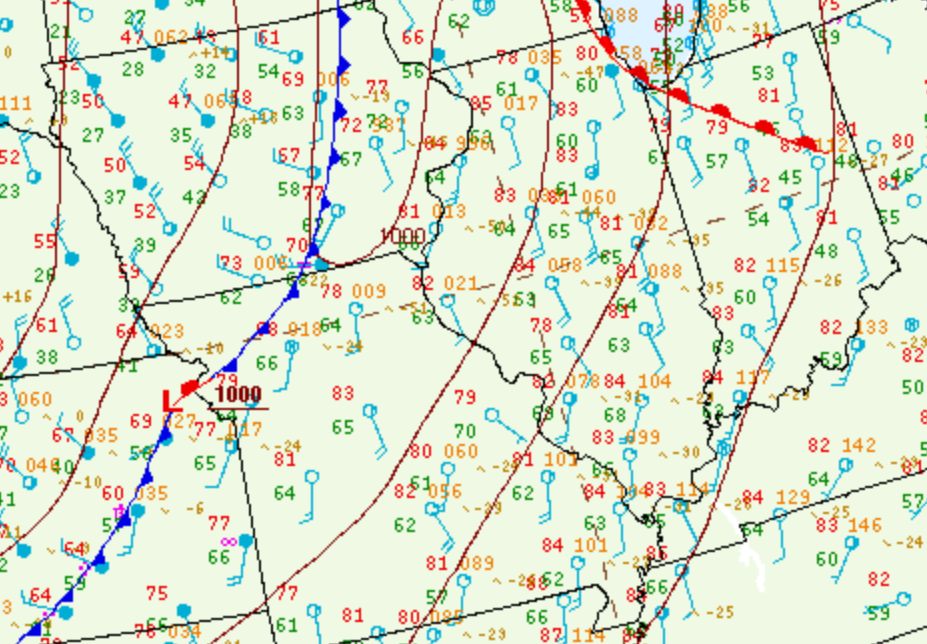
With an Enhanced Risk (level 3 of 5) for severe weather and an increasingly warm and humid airmass in place, NWS Lincoln opted to launch a special 21z/4pm weather balloon to gather supplemental data. The resulting sounding showed a strongly unstable environment with Surface Based Convective Available Potential Energy (SBCAPE) of 2723J/kg and only very weak convective inhibition. Winds were southerly at the surface, then veered westerly and increased to around 50kt at 6km aloft, creating deep-layer shear on the order of 43kt. Storm relative helicity (which measures the potential for an updraft to rotate) was 118 m2/s2. The sounding also displayed an inverted-V signature, indicative of a dry sub-cloud airmass and thus an elevated risk for strong thunderstorm downdrafts. The corresponding Downward Convective Available Potential Energy (DCAPE) was an impressive 1040J/kg.
NWS LINCOLN (ILX) UPPER AIR SOUNDING 4PM CDT APRIL 17, 2026
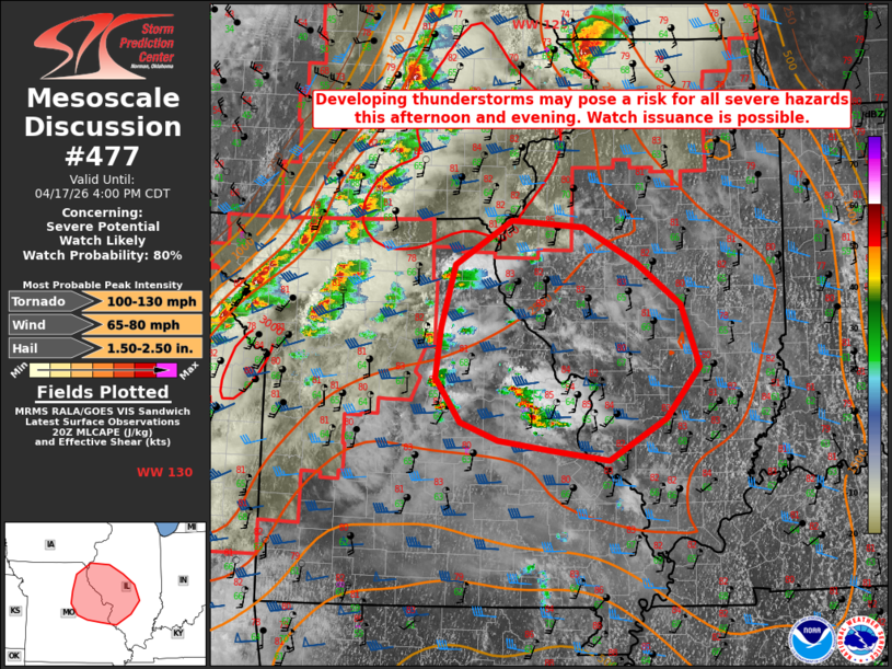
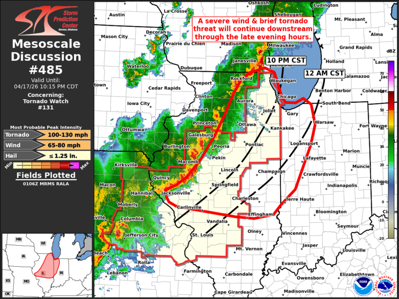
At 3:04PM CDT, the Storm Prediction Center (SPC) issued a Mesoscale Convective Discussion (MCD) for parts of central Illinois. A pre-frontal trough interacting with the unstable/sheared airmass had triggered scattered thunderstorms across eastern Missouri. SPC was concerned the cells would rapidly intensify and pose a tornado and very large hail risk as they lifted northward along and west of the I-55 corridor through the remainder of the afternoon. After a conference call with the affected NWS offices, a Tornado Watch was issued along and west of a McLean County to Shelby County line at 3:32pm CDT.
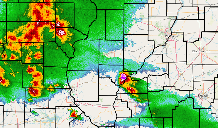
The eastern Missouri cells strengthened as expected as they lifted into west-central Illinois well ahead of the main convective line during the late afternoon. Significant wind damage occurred across parts of Scott and Schuyler counties...and one of the storms dropped 2-inch diameter hail (hen egg-sized) in Ipava in Fulton County. The image below shows the severe hail-producing storm shortly before impacting Ipava.
RADAR IMAGERY 5PM CDT APRIL 17, 2026
Once the initial batch of convection had tracked northward out of the area and/or weakened, attention quickly turned to a line of thunderstorms crossing the Mississippi River. As the line accelerated eastward, widespread damaging wind gusts of 60-70mph began impacting the Illinois River Valley. By 8:09pm CDT, SPC issued another Mesoscale Convective Discussion...this time highlighting the damaging wind threat with embedded tornadoes eastward across the remainder of central Illinois into western Indiana. As a result of continued trends, NWS Lincoln extended the original Tornado Watch eastward to the Indiana border for all counties along and north of the I-70 corridor at 8:32pm CDT.
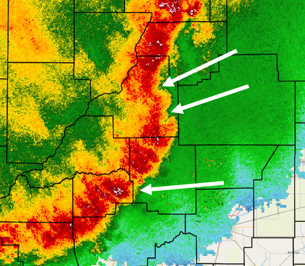
As a nocturnal low-level jet oriented from the southern Plains to the Great Lakes began intensifying after dark, Storm Relative Helicity (SRH) increased from around 100 m2/s2 from the afternoon and evening upper air soundings to 250-300 m2/s2 as per 8pm CDT SPC mesoanalysis. Given the uptick in this parameter, numerous circulations formed along the leading edge of the squall line, resulting in rapid tornadic development between 8pm and 10pm CDT. Nearly every notch and kink along the line exhibited rotation and raised concern for tornadoes. In the radar imagery below, note the numerous notches along the line denoted by the white arrows.
RADAR IMAGERY 8:45PM CDT APRIL 17, 2026
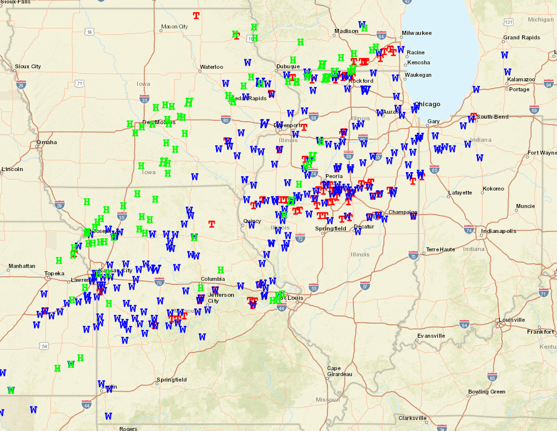
Damage reports were received in rapid succession as the line crossed I-55. As daytime instability gradually waned, the storms began to lose their intensity as the passed I-57 and headed toward the Indiana border after 10pm. The map below shows the regional extent of the April 17th severe weather episode...with dozens of damaging wind, large hail, and tornado reports extending from eastern Kansas northeastward to the southern Great Lakes. Across central Illinois, nearly all reports came from locations along and north of a Jacksonville to Danville line...with very little significant weather occurring further south.
SEVERE WEATHER REPORTS FROM APRIL 17, 2026
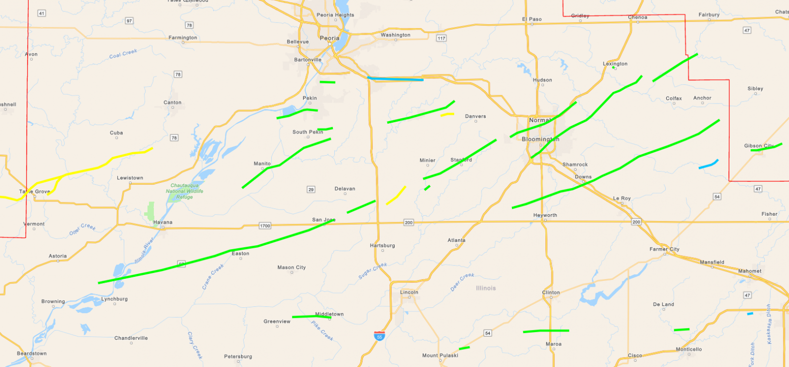
After multiple days of storm damage surveys, it was determined a total of 28 tornadoes had touched down across the NWS Lincoln CWA. The strongest were rated EF-2 with maximum winds of 115-130mph. Thankfully no major injuries or deaths occurred: however, quite a bit of tree, power line, and minor structural damage was reported. Bloomington-Normal was the largest population center impacted and experienced widespread power outages due to numerous downed trees and power poles. The 28 tornadoes marks the most ever recorded in one calendar day across NWS Lincoln's central Illinois counties...topping the previous record of 26 established on April 2, 2006.
APRIL 17, 2026 TORNADO TRACKS OVERVIEW (BLUE: EF-0, GREEN: EF-1, YELLOW: EF-2)
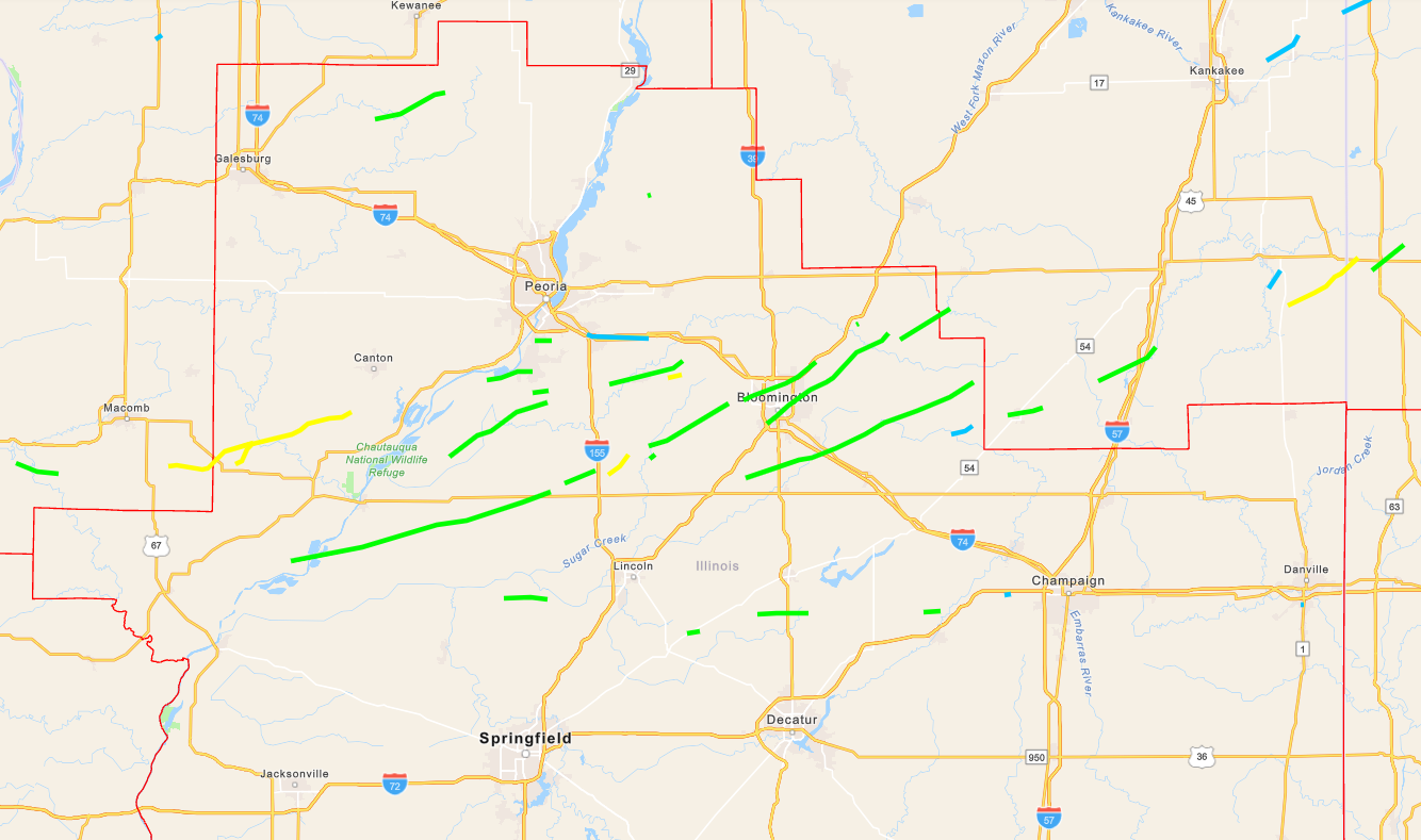
APRIL 17, 2026 TORNADO TRACKS CLOSE-UP