April 27, 2026
A strong storm system brought two rounds of significant convection to central Illinois on April 27th. The first arrived during the morning well north of an approaching warm front and resulted in scattered reports of damaging wind gusts and hail as large as ping pong balls (1.50 inches in diameter). The second bout of thunderstorms formed in the late afternoon and early evening and brought widespread damaging wind gusts of 60-80mph, tornadoes, and scattered flash flooding.
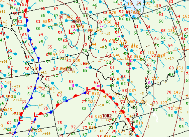
10am CDT surface analysis showed a cold front extending from Minnesota to Oklahoma. Numerous waves were noted along the front, including a 998mb low over northwestern Iowa and a 1001mb low over southeastern Kansas. A warm front extended northeastward from the Oklahoma low into Missouri and far western Tennessee. Easterly winds north of the warm front were keeping conditions cool across central Illinois with readings mostly in the upper 50s and lower 60s. Meanwhile south of the boundary, temperatures had soared into the middle to upper 70s across southern Missouri. Scattered showers and thunderstorms were developing well north of the warm front across eastern Missouri into central Illinois...while a larger area of convection that had formed on the nose of a nocturnal low-level jet across the Plains overnight was pushing eastward toward the Mississippi River.
SURFACE MAP 10AM CDT APRIL 27, 2026
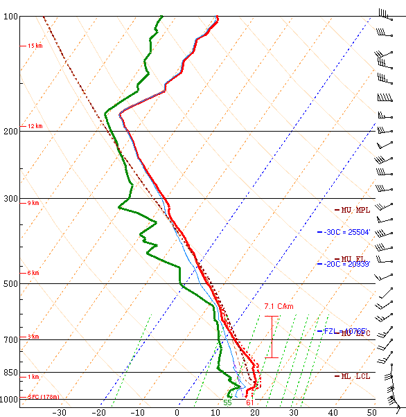
The morning upper air sounding from National Weather Service Lincoln (ILX) revealed a stable airmass with Most Unstable Convective Available Potential Energy (MUCAPE) of 60J/kg. While there was a high degree of directional wind shear due to winds veering from southeasterly at the surface to westerly aloft, speed shear remained weak thanks to 6km winds of only 15kt. The resulting 0-6km bulk shear was 25kt.
NWS LINCOLN UPPER AIR SOUNDING 7AM CDT APRIL 27, 2026
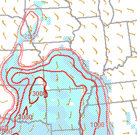
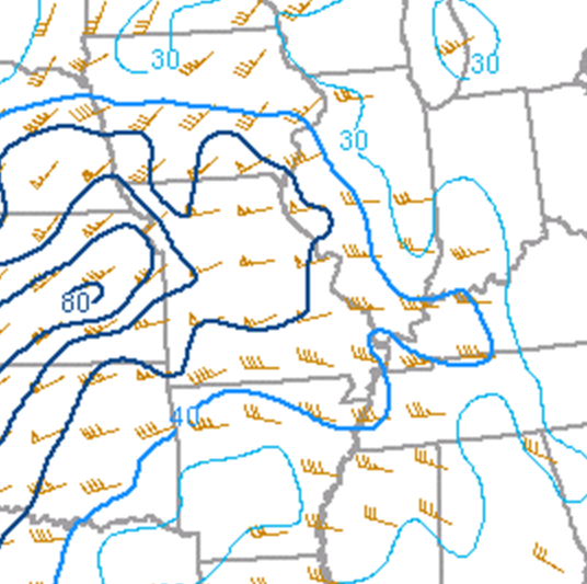
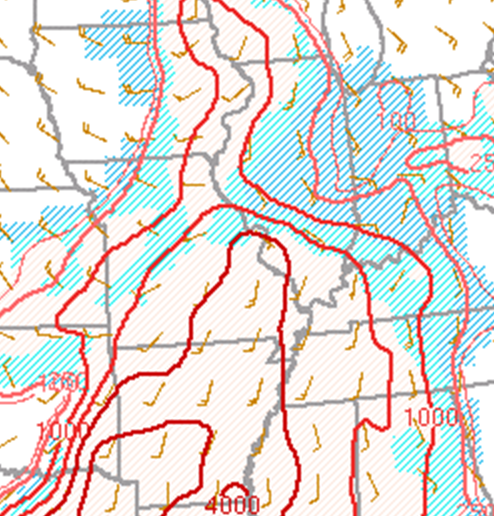
7am CDT mesoanalysis from the Storm Prediction Center (SPC) showed the stable and weakly sheared environment across central Illinois: however, it also highlighted a considerably more unstable and sheared airmass poised just upstream from Missouri south-southwestward to Texas and Oklahoma. Note values of Mixed Layer Convective Available Potential Energy (MLCAPE) of 1000-3000J/kg and 0-6km shear increasing to 50-70kt across Missouri.
MLCAPE 7AM CDT APRIL 27, 2026 0-6KM BULK SHEAR 7AM CDT APRIL 27, 2026
 |
 |
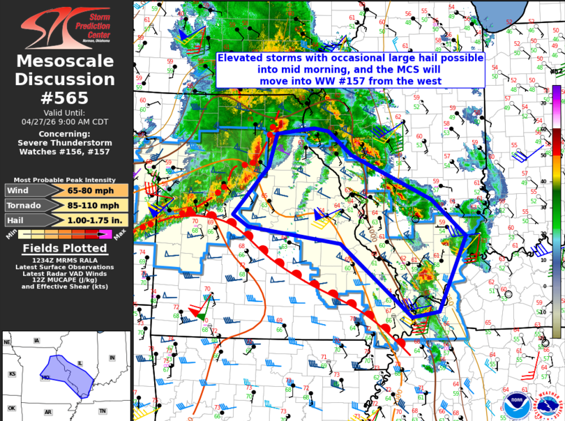
While it was clear the best instability/shear would remain southwest of central Illinois during the morning, there was growing concern that enough elevated instability would advect into the area to support a large hail and damaging wind risk with some of the developing thunderstorms. As a result, SPC issued a Mesoscale Convective Discussion (MCD) at 7:36am CDT highlighting the elevated convection. In the image below, note the scattered cells well north of the warm front from Quincy southeastward to near Effingham...and the more prominent line of convection further west across northern and central Missouri. A Severe Thunderstorm Watch was subsequently issued for nearly all of the NWS Lincoln County Warning Area (CWA) except for Knox, Stark, and Marshall counties at 8:30am CDT. Shortly afterward, the first large hail reports of the event were received between 8:50am and 9:00am CDT across parts of Sangamon County.
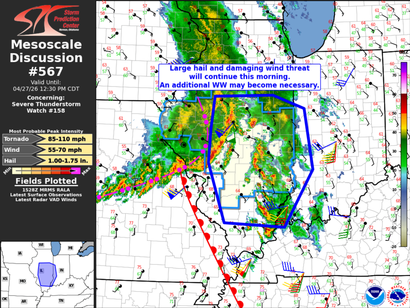
SPC issued another MCD at 10:31am CDT for the advancing squall line, as well as the scattered cells ahead of the line across east-central Illinois. As the line advanced eastward through early afternoon, numerous 50-70mph wind gusts were reported along and south of the I-72 corridor...including a measured 56mph gust at the Decatur Airport and a measured gust of 71mph from a personal weather station in Oblong in Crawford County.
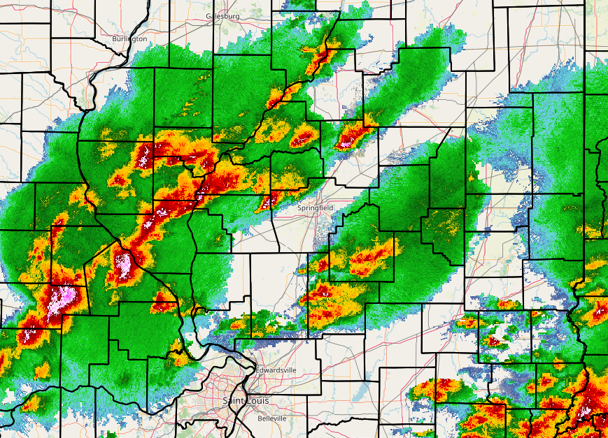
Once the squall line advanced into Indiana, much of central Illinois saw a lull in the action by mid-afternoon...with storms only lingering along and south of I-70. The main question then became how much destabilization would occur in the wake of the morning convection as the cold front crossed the Mississippi River during the late afternoon and evening. While the radar was relatively quiet for several hours, additional cells began forming ahead of the cold front across the Illinois River Valley after 4pm.
RADAR IMAGERY 4:55PM CDT APRIL 27, 2026
With cells rapidly re-developing and the atmosphere seemingly re-loading, a Tornado Watch was issued for all locations east of the Illinois River and south of a Mason County to Vermilion County line at 4:40pm CDT. 5pm CDT mesoanalysis from SPC indicated lingering stability and convective inhibition (capping) across eastern Illinois into Indiana: however, a narrow plume of instability characterized by MLCAPE of 1000-2000J/kg was noted immediately ahead of the cold front near and just east of the Mississippi River. Deep-layer wind shear had increased dramatically thanks to the arrival of a vigorous short-wave trough aloft, resulting in 0-6km bulk shear jumping from early morning values of 25-30kt to an impressive 70-75kt.
MLCAPE 5PM CDT APRIL 27, 2026 0-6KM BULK SHEAR 5PM CDT APRIL 27, 2026
 |
 |
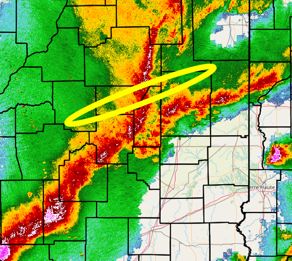
The developing cells across the Illinois River Valley efficiently tapped into the increasingly unstable and sheared environment and quickly evolved into a squall line by early evening. While a few of the cells initially produced hail up to the size of ping pong balls between the Illinois River and I-55, the primary hazards became damaging wind gusts of 60-80mph and embedded tornadoes as the mature squall line raced eastward. Numerous reports of wind damage were received from I-55 eastward to the Indiana border between 6pm and 10pm CDT before the line departed into the Ohio River Valley. The radar imagery below shows the leading edge of the storms extending from far eastern McLean County southwestward to Christian County at 7:00pm CDT. After conducting storm damage surveys, NWS Lincoln determined 5 EF-1 tornadoes touched down from Mount Pulaski in southern Logan County northeastward to near Mahomet in northern Champaign County (yellow oval in image). This is where the line was most prominently bowing forward and where several cell mergers occurred.
RADAR IMAGERY 7:00PM CDT APRIL 27, 2026
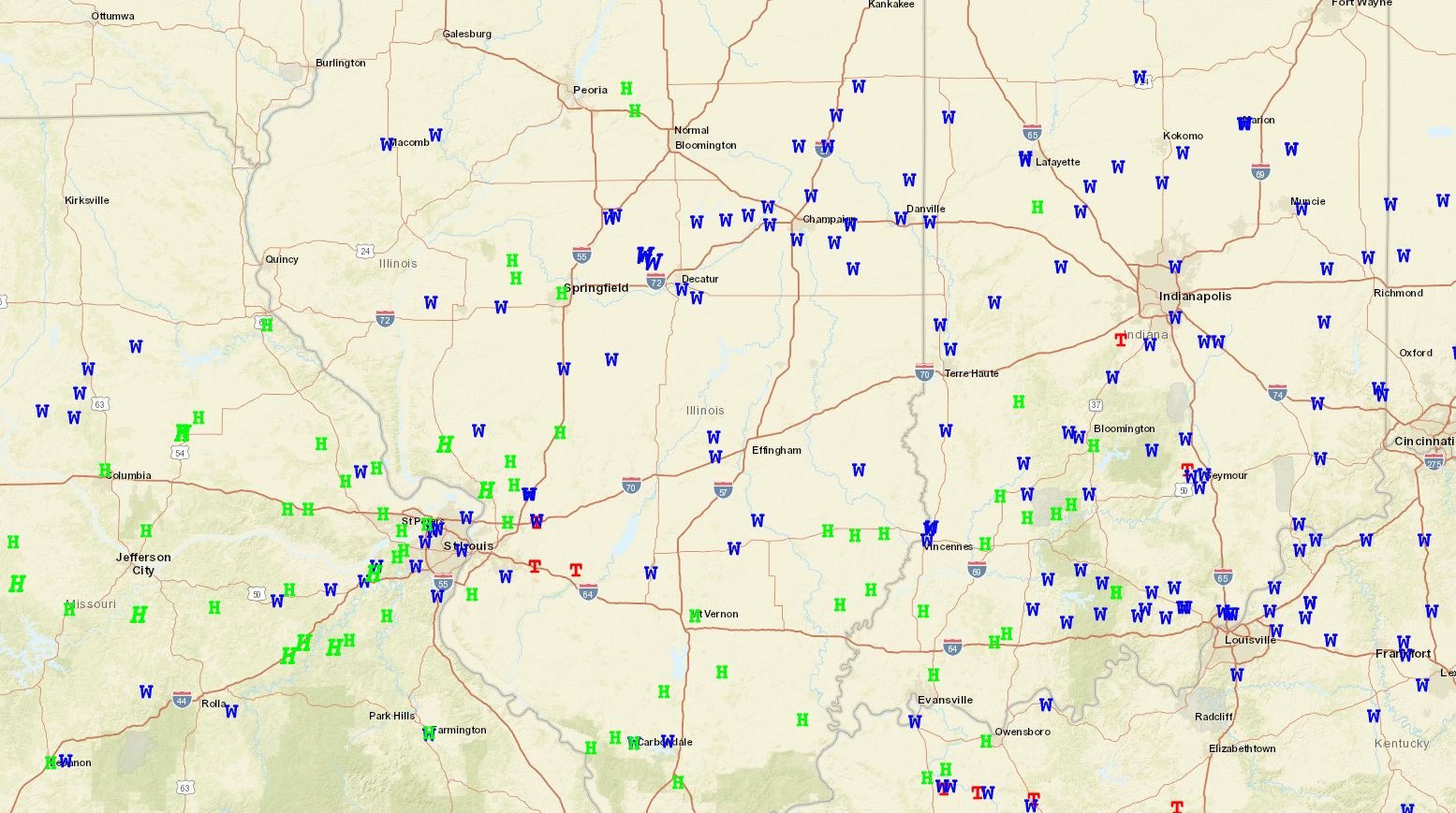
NWS Lincoln issued a total of 55 severe thunderstorm and tornado warnings on April 27th, breaking the previous calendar day office convective warning record of 50 established on March 21st, 2023. As you can see from the preliminary storm mapping below, this was a significant severe weather event that impacted a large swath of Missouri, Illinois, Indiana, and Kentucky.
SEVERE WEATHER REPORTS FROM APRIL 27, 2026