September 18-19, 2022
Several clusters of strong to severe thunderstorms developed ahead of an approaching cold front during the evening of September 18th into the early morning hours of September 19th. The strongest storms impacted locations along and north of I-74 from Peoria southeastward to Champaign-Urbana...as well as areas from Rushville to Jacksonville. An EF-0 tornado with winds around 85mph touched down near Leroy in McLean County causing minor roof damage and downing several trees and power poles. Meanwhile, other storms packing winds of 60-70mph blew down trees on the south side of Jacksonville. A few of the cells dropped very large hail...with up to tennis ball-sized hailstones being reported in Mahomet in northwest Champaign County.
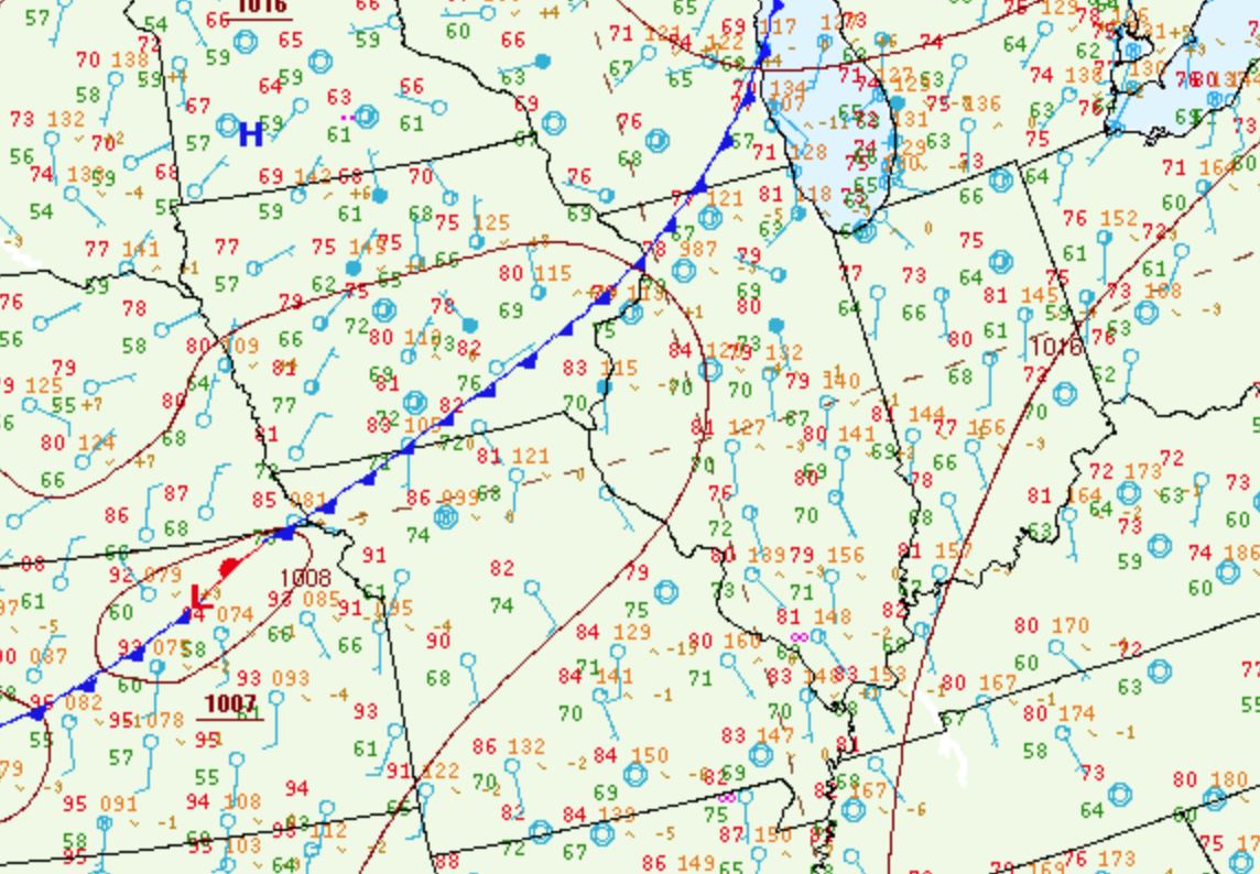
Surface analysis from the early evening of September 18th showed a cold front extending from the Upper Peninsula of Michigan southwestward to near Kansas City. The airmass ahead of the front was quite warm and humid with temperatures in the lower 80s and dewpoints hovering in the lower 70s.
SURFACE WEATHER MAP 7PM CDT SEP 18
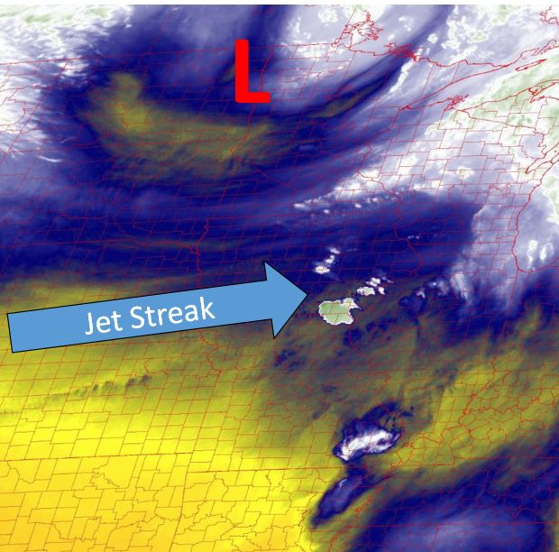
Conditions aloft featured a vigorous trough over the Upper Midwest with a prominent jet streak pivoting around the upper system from Nebraska into Iowa. Note the swirl over North Dakota into Minnesota depicting the trough on the water vapor imagery below. The light green features over southeast Iowa are thunderstorm cells beginning to develop on the nose of the jet streak.
WATER VAPOR IMAGERY 7PM CDT SEP 18
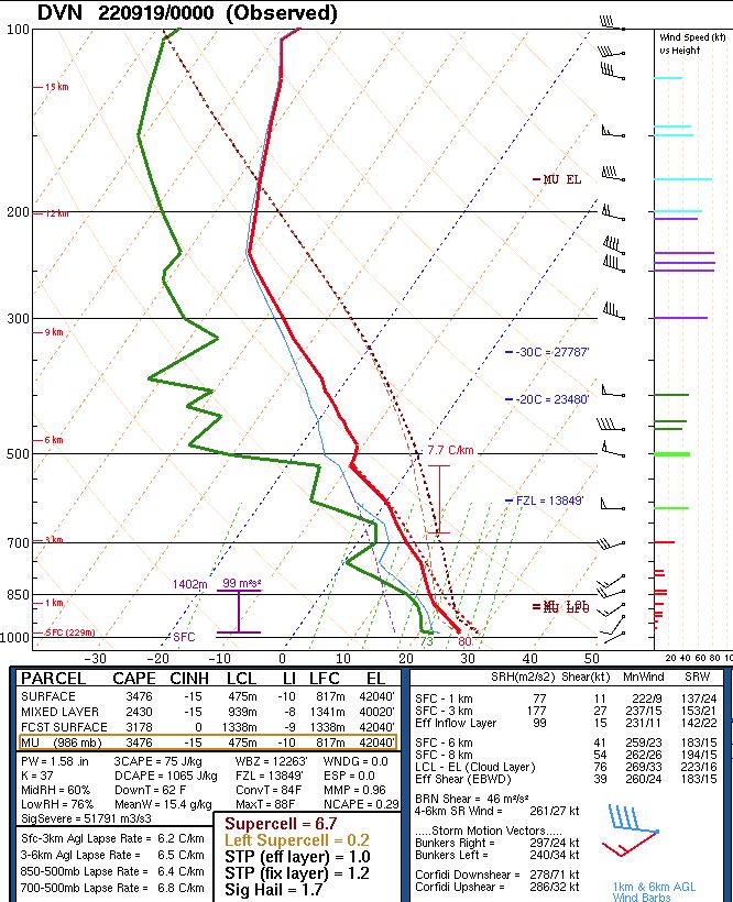
The evening upper air balloon launch from National Weather Service Quad Cities showed an unstable airmass characterized by Mixed Layer Convective Available Potential Energy (MLCAPE) values of around 2500J/kg. In addition, deep-layer shear was on the increase thanks to the approaching jet streak...with 0-6km bulk shear at 40kt. Note both the directional and speed shear on the upper air sounding below. Winds at the surface were from the southwest at 5kt, then veered to the west-northwest and increased to 50kt at 6km aloft. In addition, copious amounts of moisture were present below 6km...resulting in a precipitable water value of 1.58, which is in the 95th percentile for the date.
NWS QUAD CITIES UPPER AIR SOUNDING 7PM CDT SEP 18
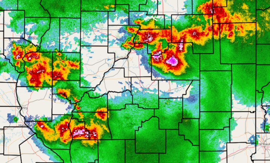
With ample instability, deep-layer moisture, and increasing wind shear in place, the stage was set for a severe weather event across parts of central Illinois. While cells were initially slow to develop due to mid-level capping within the warm sector of the system, thunderstorms rapidly initiated across southeast Iowa by the early evening of September 18th. Areal coverage of thunderstorms increased along and ahead of the cold front as the evening progressed...with two prominent clusters noted. The first tracked from Marshall and Peoria counties southeastward along and north of I-74 into McLean and northern Champaign counties, while the second focused across Schuyler, Scott, and Morgan counties.
DOPPLER RADAR 1150PM CDT SEP 18
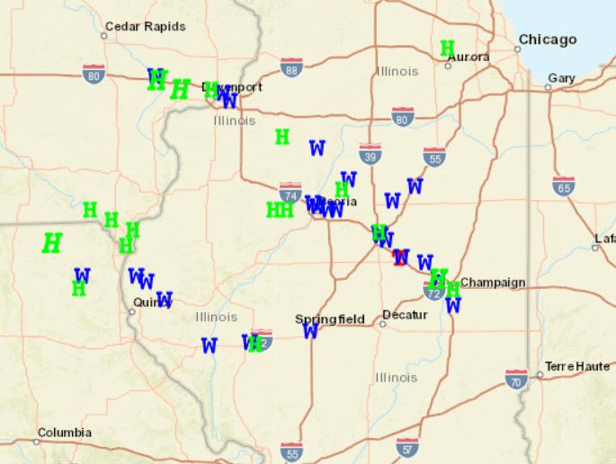
A review of the storm reports from September 18-19 clearly shows two distinct swaths of severe weather across central Illinois...one along I-74 and another from southeast Iowa to Jacksonville. Locations in between were largely missed. In addition, areas east of I-57 and south of I-70 did not experience severe storms.
SEVERE WEATHER REPORTS SEP 18-19