Top 10 Weather Events of 2025
1) January 5-6: Heavy Snow Across South-Central Illinois
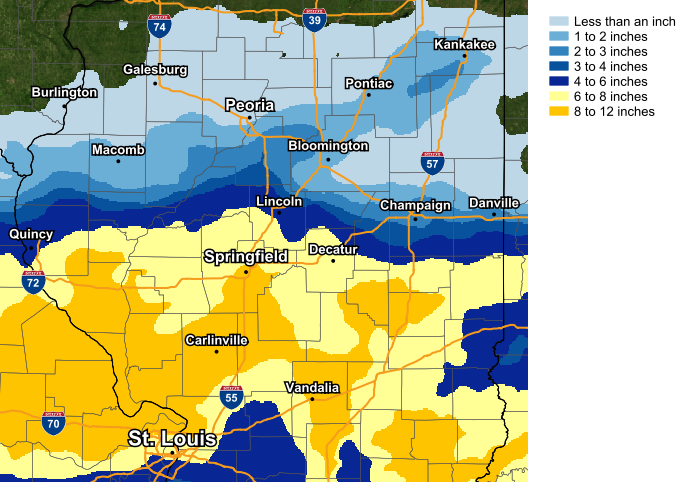
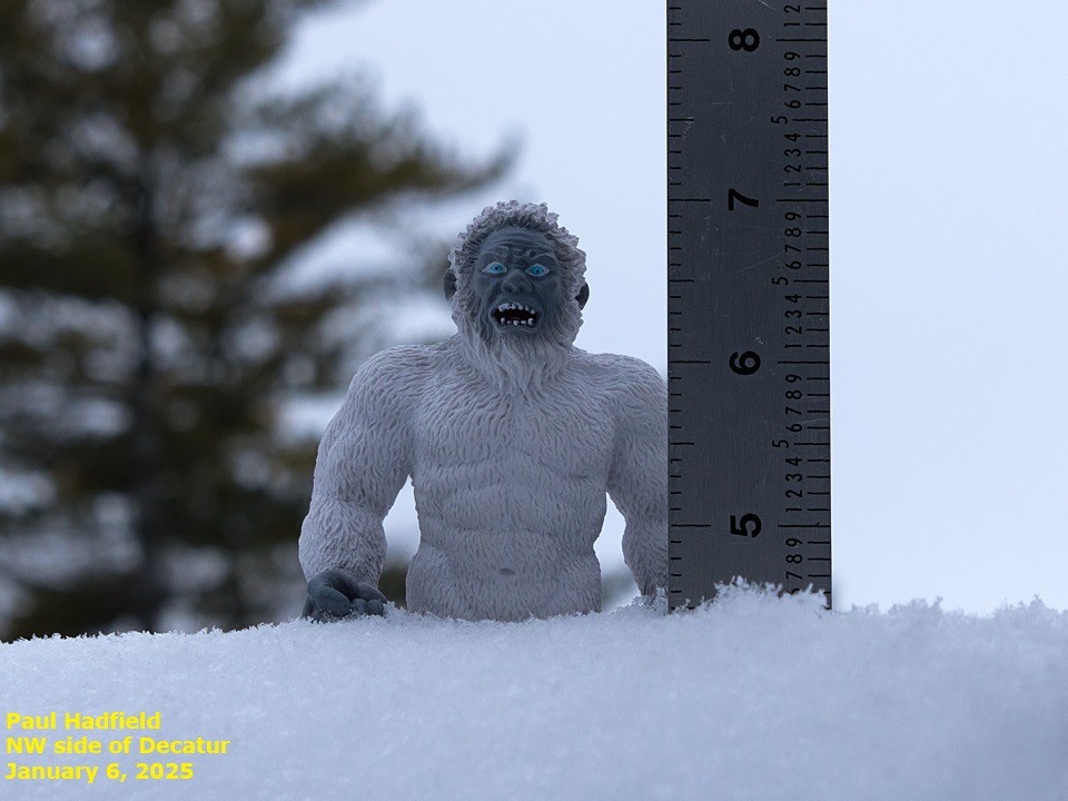
A major winter storm system impacted south-central Illinois from the morning of January 5th through the morning of January 6th. Snow was the primary precipitation type, although the profile warmed enough to produce some sleet and freezing drizzle south of the I-70 corridor. Due to dry air flowing southeastward from the Great Lakes, there was a sharp northern gradient to the snowfall...with locations north of I-74 generally picking up 1 inch or less...while slightly further south along and south of a Rushville...to Lincoln...to Paris line impressive amounts of 6 to 10 inches were noted. Due to the heavy snowfall, numerous traffic accidents were reported. A 40-50 vehicle crash closed east-bound I-70 at mile marker 119 near Effingham, while west-bound I-70 at exit 129 near Casey was also closed for a time. In addition, north-bound I-55 between mile markers 123 and 133 just south of Lincoln was shut down due to an accident.
January 5-6 Snowfall
=======================================================================================================================
2) March 14-15: Eight Tornadoes
A potent low pressure system progressed across the Midwest on Friday, March 14, 2025. Ahead of this system, temperatures soared nearly 30 degrees above normal with high temperatures reaching the lower 80s across central Illinois. Peoria established a new record high for the date of 82 degrees, while Lincoln and Springfield tied their records of 82 and 83 respectively. A strong cold front swept across Illinois during the evening into the overnight hours, with a line of severe thunderstorms developing ahead of the front. These storms produced widespread damaging straight-line winds and eight tornadoes within the NWS Lincoln County Warning Area, all of which occurred in eastern Illinois. Two of these tornadoes were rated EF-2: one in Moultrie and Piatt counties, and another in Cumberland and Coles counties. The latter resulted in two injuries.
March 14-15 Tornado Tracks


=============================================================================================================================
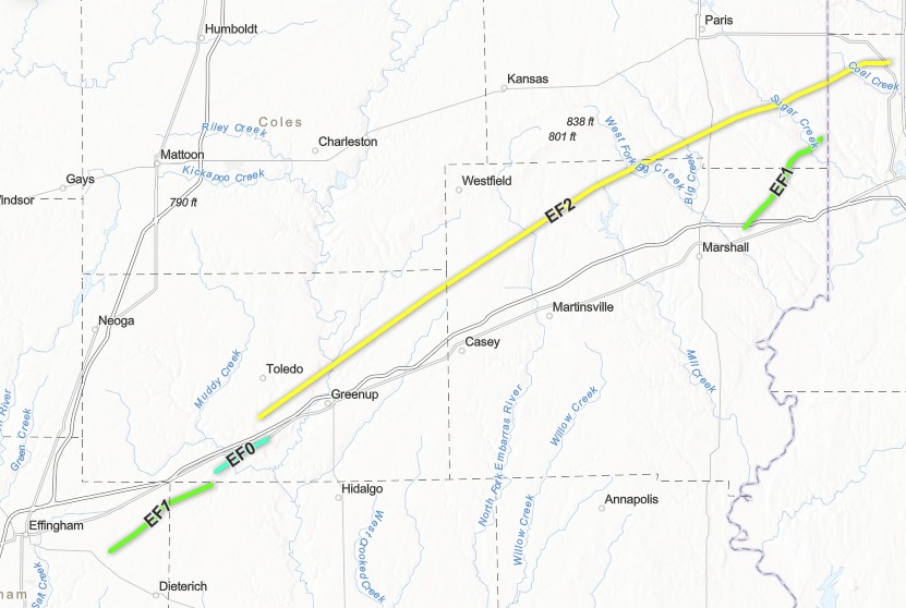
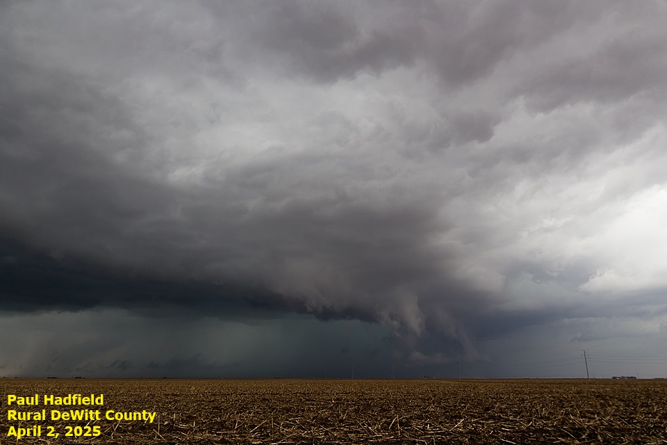
3) April 2: Long-Track EF-2 Tornado Near I-70
An area of low pressure tracked from southeastern Nebraska during the morning of April 2nd to western Wisconsin by evening, triggering two rounds of convection across central Illinois.
ROUND 1 occurred during the morning when a line of thunderstorms along the trailing cold front pushed into the Illinois River Valley. These storms were generally sub-severe, but one cell produced a downburst with estimated winds in excess of 70 mph across parts of Logan County...downing a few trees, tearing the roof off a business, and flipping 3 semis in and near Lincoln.
ROUND 2 materialized by early afternoon as storms re-developed along an outflow boundary from the morning convection along the I-55 corridor. These storms tapped into a moderately unstable and highly sheared environment and quickly became severe. Six tornadoes touched down...including a long-track EF-2 tornado that remained on the ground for nearly 45 miles and impacted parts of Cumberland, Clark, and Edgar counties before crossing into Vigo County, Indiana. Numerous reports of wind damage and large hail were received as the storms congealed into a line and pushed eastward across I-57 by early evening. The largest reported hail stones were the size of eggs (2" in diameter) in Springfield in Sangamon County and just northwest of Latham in southern Logan County.
April 2 Tornado Tracks Along I-70
=============================================================================================================================
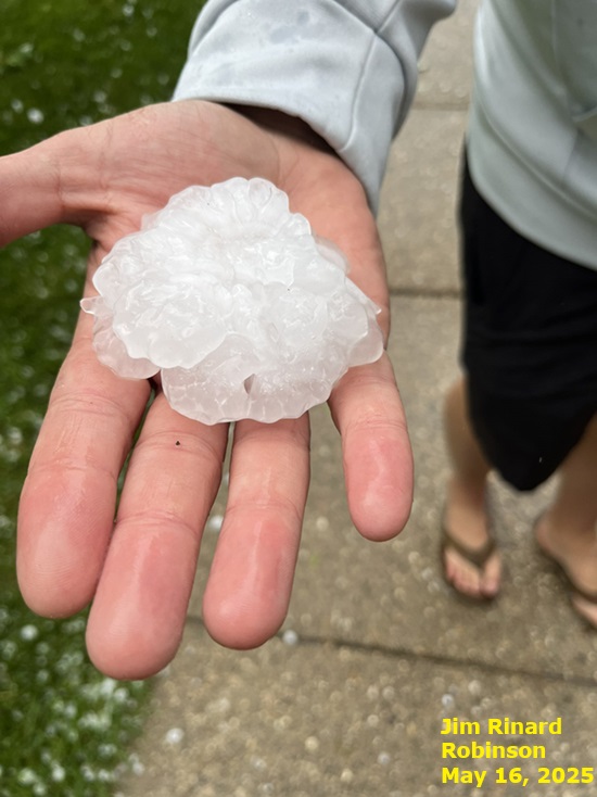
4) May 16: Very Large Hail
Scattered supercell thunderstorms developed in the vicinity of a nearly stationary frontal boundary draped along I-70 during the afternoon and early evening of May 16th. The storms first formed along a Springfield to Saint Louis line, then tracked east-northeastward generally south of the I-72 corridor, causing sporadic wind damage...most notably in the Decatur and Effingham areas. In addition, the highly unstable airmass to the south created vigorous storm updrafts which supported very large hail. Upon initial storm development, a few stones as large as golf balls occurred on the southeast side of Springfield to near Riverton. However, an even stronger cell later in the afternoon dropped 3-inch diameter hail (larger than a baseball) in Robinson in Crawford County. Another nearby storm produced an EF-1 tornado that tracked across portions of northern Crawford and southern Clark County before crossing the Wabash River into Sullivan County, Indiana.
=============================================================================================================================
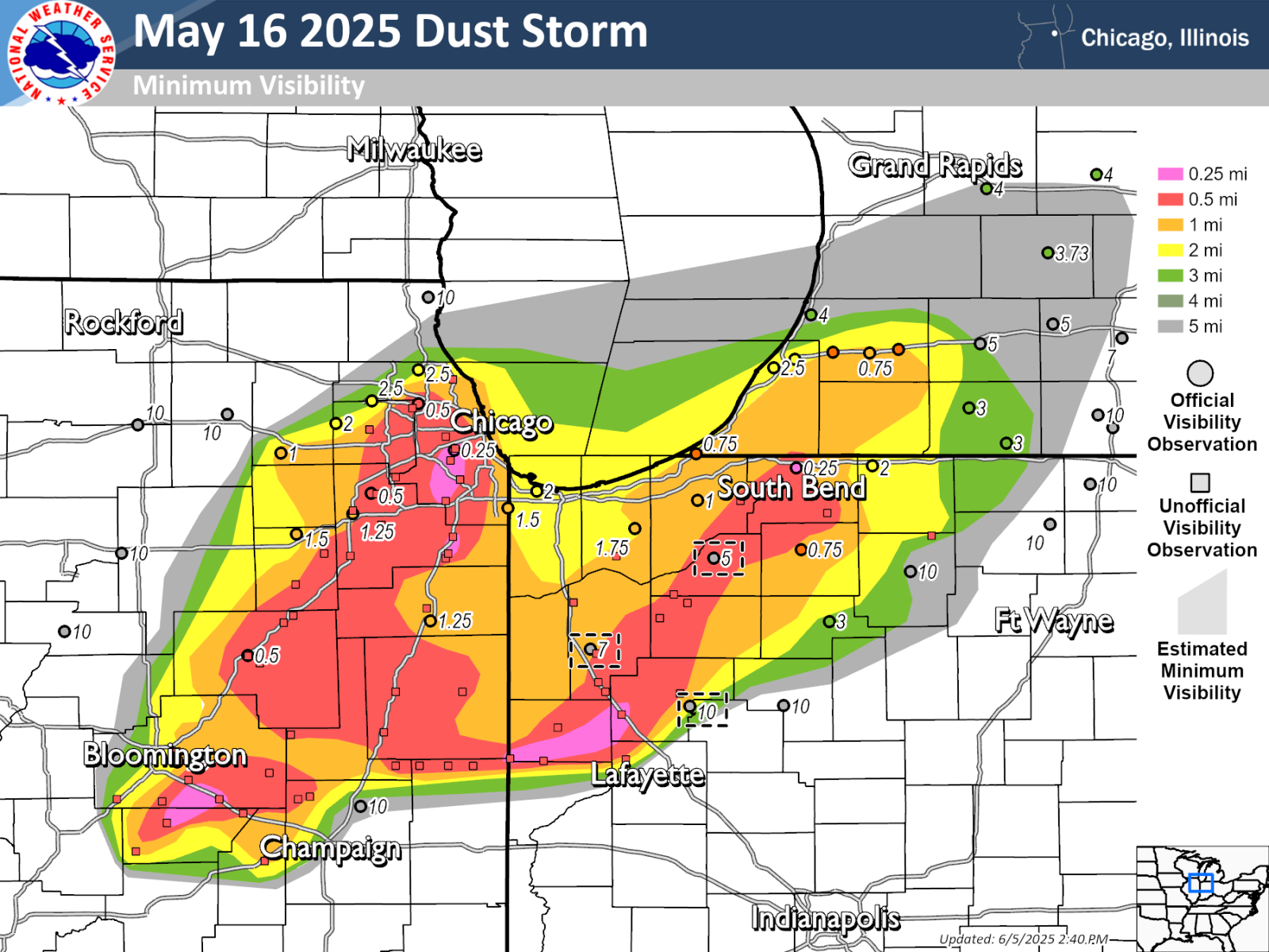
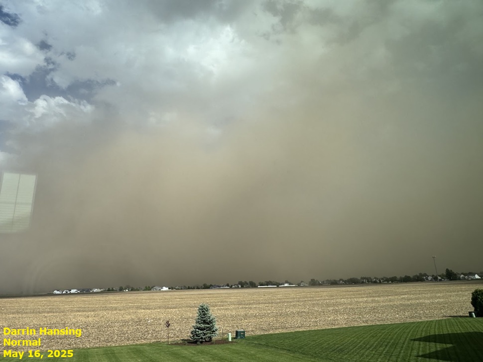
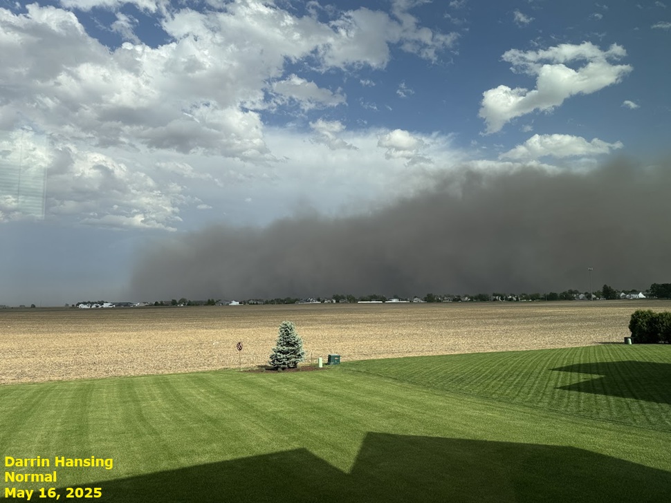
5) May 16: Dust Storm Across East-Central Illinois
A nearly stationary frontal boundary draped along I-70 separated a warm, humid airmass to the south across the Ohio River Valley from a warm, but considerably drier airmass further north across much of central and northern Illinois on May 16th. Thunderstorms developed near the boundary during the afternoon and early evening, with the activity remaining largely south of I-72. Thanks to a very dry sub-cloud environment, developing showers to the north of the thunderstorms were able to mix higher momentum air from aloft down to the surface....resulting in 60-70 mph wind gusts well away from falling precipitation. The high momentum air began to pick up dry soil from open farm fields and created an impressive dust-storm as the afternoon progressed. The dust initially developed along a line from just southeast of Lincoln to south of Champaign. It then lifted north-northeastward and eventually spread all the way into the Chicago metro. Visibilities were reduced to near zero at times within the dust plume, prompting the closure of numerous roads and resulting in a few traffic accidents with injuries.
Minimum Visibility Map (courtesy of NWS Chicago)
 |
 |
=============================================================================================================================
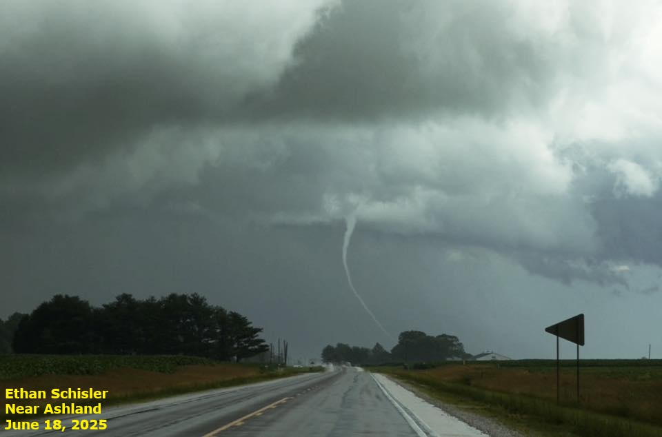
6) May 20: Six Tornadoes and Very Large Hail
A warm front lifted slowly northward through central Illinois during the afternoon of May 20th. A few showers developed in the vicinity of the boundary...with one of the cells producing a brief EF-0 tornado near Oakland in northeastern Coles County. Meanwhile further west, scattered supercell thunderstorms formed in the warm sector ahead of a cold front crossing the Mississippi River. Some of the storms dropped hail as large as tennis balls (2.5" in diameter) across portions of Morgan County as they initially developed. As the storms continued further eastward, several weak tornadoes were observed: one near Latham in southeastern Logan County and four additional tornadoes further east across eastern Champaign County into Vermilion County. The strongest tornado was rated EF-1 as it snapped two power poles and damaged numerous trees near Armstrong and Potomac in Vermilion County. Further southeast, a downburst with estimated 90 mph winds created widespread wind damage on the south side of Westville in Vermilion County.
May 20 Severe Weather Reports (W= Wind, H= Hail, T= Tornado)
 |
 |
=============================================================================================================================
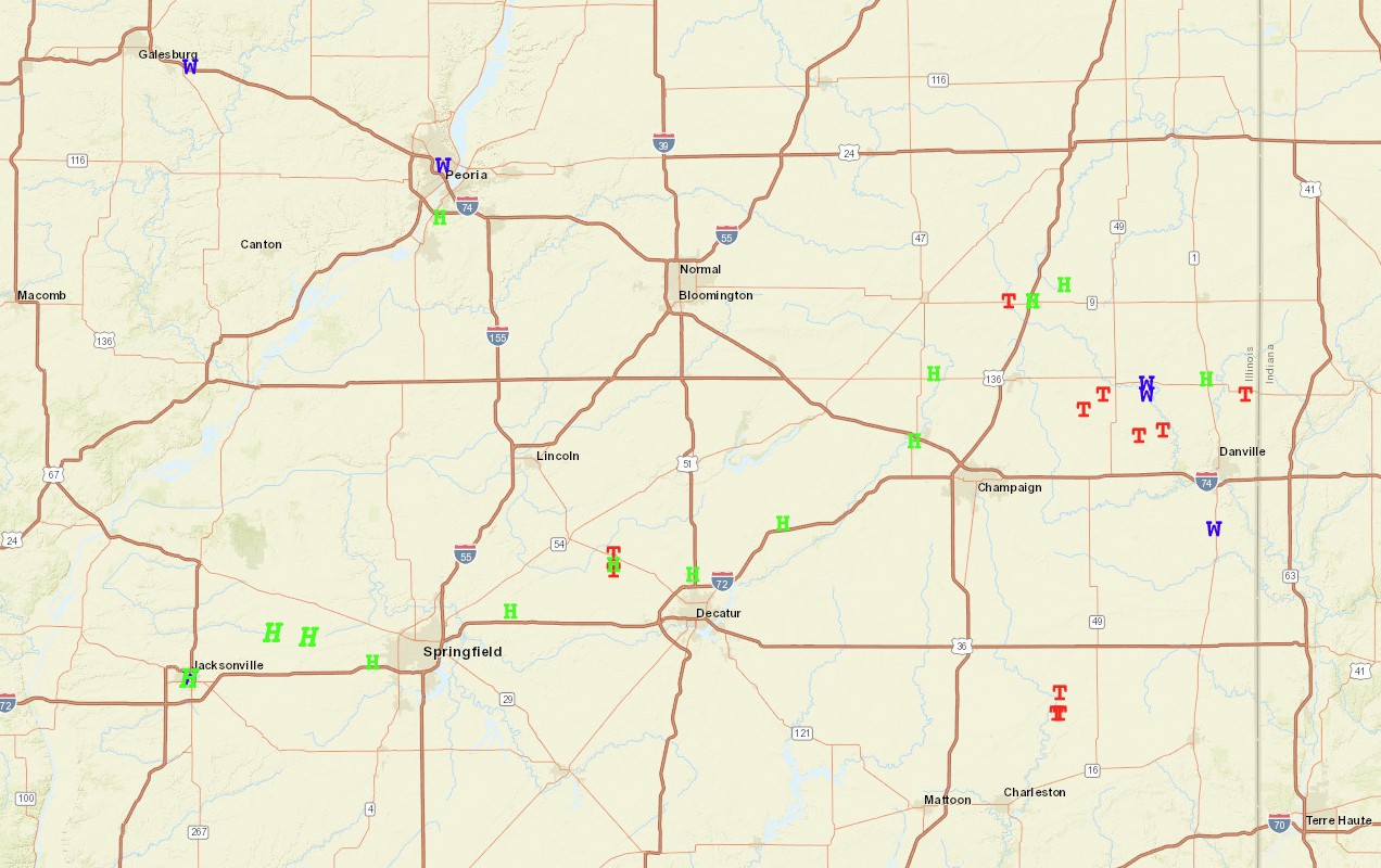
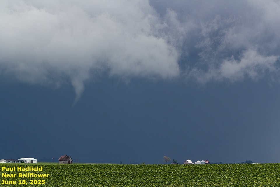
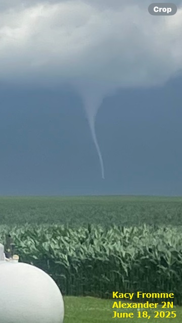
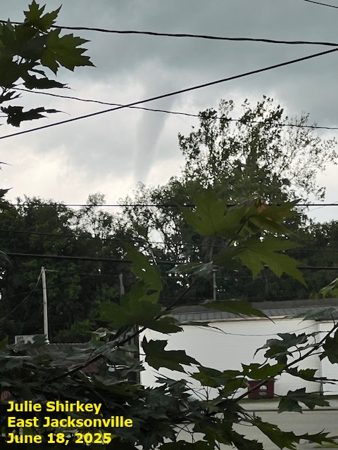
7) June 18: Fourteen Tornadoes
A mesoscale convective vortex (MCV) generated by a large cluster of nocturnal thunderstorms across the Plains moved into central Illinois during the late morning of Wednesday, June 18th. Thanks to a moderately unstable airmass, scattered strong thunderstorms developed and quickly began rotating due to the enhanced low-level wind shear associated with the MCV. A total of 14 tornadoes touched down within the NWS Central Illinois County Warning Area (CWA)...mainly west of the I-55 corridor. While 7 of the tornadoes were rated either EF-U or EF-0, there were 6 EF-1's and 1 EF-2. The strongest tornado touched down about 2.5 miles north-northeast of Jacksonville and destroyed a number of outbuildings and displaced or mangled farm equipment. No injuries were reported with this particular tornado: however, a minor injury occurred when winds associated with a separate tornado tossed a woman against her home in Morgan County.
 |
 |
 |
 |
=======================================================================================================================
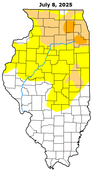
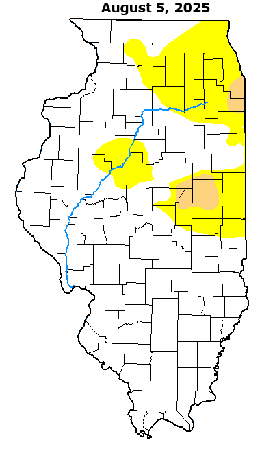
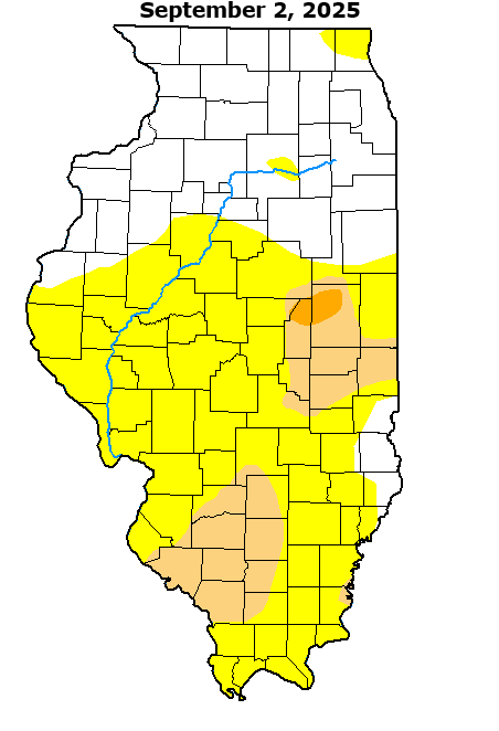
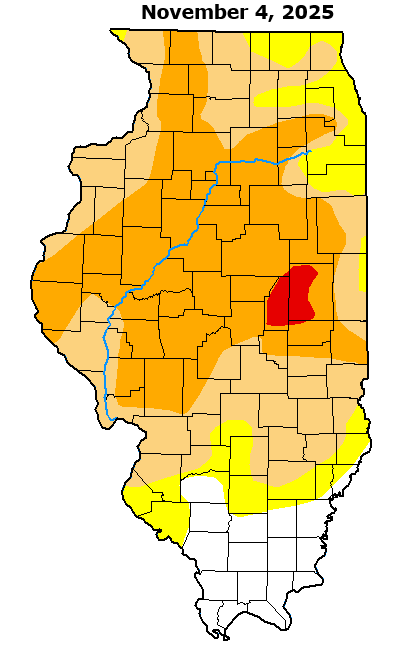
8) Severe to Extreme Drought
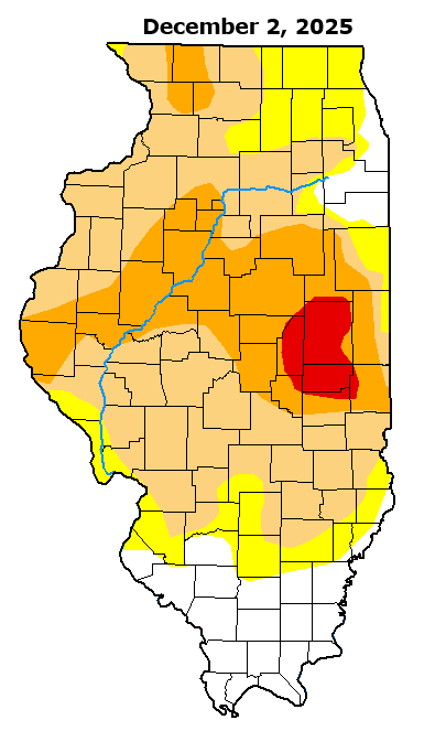
Drought conditions developed across east-central Illinois during the spring of 2025, then steadily worsened and spread across the remainder of central Illinois during the late summer and fall. While July offered a temporary respite from the dryness, rainfall decreased and drought conditions quickly engulfed the entire region by September and October. By the November 4th U.S. Drought Monitor issuance, the majority of central Illinois north of the I-70 corridor had deteriorated into the Severe Drought (D2) category...with a pocket of Extreme Drought (D3) noted across parts of Champaign and Piatt counties. While several storm systems brought heavy snowfall and much-needed moisture from the end of November into the middle of December, significant moisture deficits still exist and very little drought improvement has been noted through December 15th.
Most locations saw near or above average rainfall in July: however, all central Illinois climate sites have since experienced 4 consecutive months of below normal precipitation. The worst conditions continue to be focused over Champaign County...where a longer-term drought is ongoing. In fact, Champaign 3S has not experienced a month of above normal precipitation since December 2024.
The drought has led to a number of agricultural and hydrological impacts...including low streamflows and very poor to record low water tables and sub-soil moisture. The uppermost portion of the Sangamon River basin is experiencing near record low flow, which is significantly impacting downstream water levels. As a result, both Lake Decatur and Lake Shelbyville are more than 2 feet below seasonal norms. The extremely dry conditions also led to numerous community burn bans and water restrictions during the fall.
Here is a series of images showing the progression of the drought as depicted by the U.S. Drought Monitor from July through December:
U.S. Drought Monitor (Abnormally Dry, Moderate Drought, Severe Drought, Extreme Drought)
 |
 |
 |
 |
 |
 |
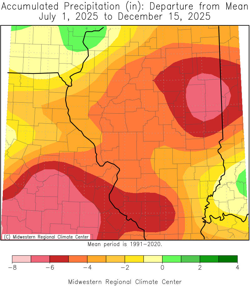
This image from the Midwest Regional Climate Center (MRCC) shows the departure from mean precipitation from July 1st through December 15th. Note the bullseye over Champaign County indicating a deficit of over 7 inches during that time.
Rainfall Departures from Mean by Month
| June | July | August | September | October | November | |
| Peoria | +0.35 | -0.07 | -2.26 | -3.39 | -1.21 | -1.08 |
| Lincoln NWS | +0.77 | +2.96 | -0.67 | -0.78 | -1.90 | -0.95 |
| Springfield | -0.69 | +2.99 | -3.21 | -2.32 | -1.98 | -0.11 |
| Champaign 3S | -1.94 | -0.03 | -2.33 | -1.46 | -1.82 | -1.92 |
=============================================================================================================================
9) November 26-Dec 15: Extreme Cold and Snow
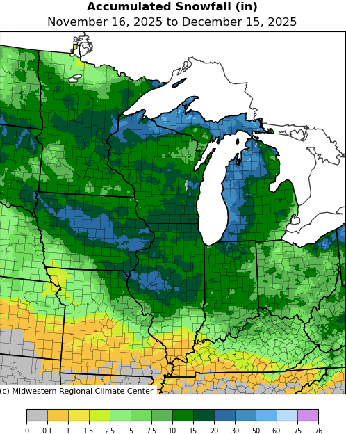
After a period of unseasonably warm weather in mid-November that saw temperatures peak in the middle 70s on November 14th and 15th, sharply colder conditions arrived the day before Thanksgiving. As the cold airmass intensified, low pressure tracking from near Kansas City to southern Lake Michigan brought heavy snow and strong winds to central Illinois on November 29th. Snowfall ranged from 5 to 12 inches everywhere north of the I-70 corridor...with daily records being established at Springfield (8.9), Lincoln (7.8), and Peoria (5.2). Despite the wet nature of the snow, strong southeasterly winds gusting 35-45mph created considerable blowing and drifting. This first winter system was quickly followed by a second on December 1st that dropped 2 to 4 inches of snow on much of the region. Clear skies and diminishing winds in the wake of the second system led to the first sub-zero low temperatures of the season by December 4th. After a brief warm-up that resulted in significant snow melt, central Illinois was hit by two additional winter storms and even colder temperatures. A fast-moving Alberta Clipper dropped 2-4 inches of snow on December 11th...while yet another clipper system fast on the heels of the first brought even higher amounts of 4-8 inches north of I-70 on December 13th.
Storm total snowfall from November 26th through December 15th ranged from 10-20 inches everywhere north of the I-70 corridor...with a few locations along a Canton...to Lincoln...to Decatur line picking up in excess of 20 inches. These numbers represent record snowfall totals for this early in the season. In addition to the snow, a bitterly cold airmass settled into the region. Thanks to clear skies and calm winds over the deep snow cover, low temperatures plunged well below zero by December 14th and 15th. Lincoln, Champaign, and Tuscola all recorded lows of -13.
Snowfall and Temperatures (November 26-December 15)
| CITY | COUNTY | SNOWFALL | COLDEST TEMP |
| Canton | Fulton | 23.5 | n/a |
| Decatur | Macon | 21.5 | -11 Dec 14 |
| Petersburg 1N | Menard | 20.8 | -5 Dec 14 |
| Tuscola | Douglas | 19.7 | -13 Dec 15 |
| Lincoln NWS | Logan | 19.6 | -13 Dec 14 |
| Jacksonville 2E | Morgan | 19.5 | -9 Dec 14 |
| Springfield | Sangamon | 18.9 | -8 Dec 14 |
| Charleston | Coles | 17.8 | -5 Dec 14 |
| Peoria | Peoria | 16.6 | -7 Dec 14 |
| Champaign 3S | Champaign | 16.1 | -13 Dec 15 |
| Taylorville 2SE | Christian | 15.0 | -5 Dec 15 |
| Normal 4NE | McLean | 14.4 | -9 Dec 15 |
| Shelbyville | Shelby | 13.9 | -4 Dec 15 |
| Paris | Edgar | 12.1 | -9 Dec 15 |
| Galesburg | Knox | 9.1 | -8 Dec 14 |
| Effingham | Effingham | 8.3 | n/a |
| Lawrenceville 2WSW | Lawrence | 5.2 | 1 Dec 15 |
| Robinson | Crawford | 4.0 | -2 Dec 15 |
| Flora | Clay | 3.0 | 3 Dec 15 |
=============================================================================================================================
10) 49 Tornadoes Across Central Illinois in 2025
A typical year sees 20-25 tornado touchdowns within the NWS Lincoln County Warning Area (CWA). This year the majority of our tornadoes (32) occurred in the spring months: however, the day with the most tornadoes was June 18th when a total of 14 touched down. The strongest tornadoes to impact the Lincoln CWA were rated EF-2...including a long-track tornado on April 2nd that remained on the ground for over 45 miles across portions of Cumberland, Clark, and Edgar counties before crossing the Wabash River into Vigo County, Indiana.
Winter (0)
Spring (32)
| DATE | COUNTY | BEGIN LOCATION | EF-SCALE |
| March 14 | Shelby | 2 miles south-southwest of Stewardson | EF-1 |
| March 14 | Shelby | 2 miles north-northeast of Strasburg | EF-1 |
| March 14 | Moultrie | 2 miles west-northwest of Lovington | EF-1 |
| March 14 | Moultrie | 2.3 miles north-northeast of Lovington | EF-2 |
| March 14 | Cumberland | Southeast side of Neoga | EF-2 |
| March 14 | Coles | 3.5 miles north of Mattoon | EF-1 |
| March 14 | Champaign | Sellers | EF-1 |
| March 14 | Edgar | 1 mile south of Paris | EF-1 |
| March 19 | Tazewell | 6.3 miles west-northwest of Parkland | EF-U |
| March 19 | Coles | 0.8 miles northwest of Rardin | EF-1 |
| March 30 | Champaign | 3 miles south-southeast of Ivesdale | EF-1 |
| April 2 | Logan | 0.9 northwest of Latham | EF-0 |
| April 2 | Effingham | 4 miles south-southeast of Altamont | EF-1 |
| April 2 | Effingham | 0.8 east-northeast of Evers | EF-1 |
| April 2 | Cumberland | 1.7 miles southwest of Woodbury | EF-0 |
| April 2 | Cumberland | 1 mile north of Jewett | EF-2 |
| April 2 | Clark | 3 miles south of Marshall | EF-1 |
| April 20 | Knox | 1 mile west of Victoria | EF-1 |
| April 20 | Knox | 1.5 miles northeast of Altona | EF-1 |
| April 20 | Tazewell | 2 miles south of Tremont | EF-1 |
| April 30 | Effingham | 2.5 miles north of Effingham | EF-U |
| April 30 | Coles | 1.2 miles west of Campbell | EF-U |
| May 13 | Logan | 2.5 miles east-northeast of Emden | EF-U |
| May 13 | Champaign | 2.4 miles north of Champaign | EF-U |
| May 13 | Stark | 2 miles southwest of Toulon | EF-0 |
| May 16 | Crawford | 1.5 miles north-northeast of Annapolis | EF-1 |
| May 20 | Coles | Northwest side of Oakland | EF-0 |
| May 20 | Logan | Just south of Latham | EF-U |
| May 20 | Champaign | 1.5 miles southwest of Gerald | EF-0 |
| May 20 | Vermilion | 3 miles south of Armstrong | EF-1 |
| May 20 | Vermilion | 2.5 miles southwest of Collison | EF-0 |
| May 20 | Vermilion | 3 miles east of Bismarck | EF-0 |
Summer (15)
| DATE | COUNTY | BEGIN LOCATION | EF-SCALE |
| June 18 | Scott | 3.2 miles west-northwest of Glasgow | EF-U |
| June 18 | Morgan | 3.2 miles east-southeast of Lynnville | EF-0 |
| June 18 | Scott | 2.9 miles east-southeast of Riggston | EF-1 |
| June 18 | Morgan | 2.3 miles west of Jacksonville | EF-1 |
| June 18 | Morgan | 2.5 miles north-northeast of Jacksonville | EF-2 |
| June 18 | Morgan | 3.2 miles north-northeast of Alexander | EF-1 |
| June 18 | Sangamon | 2.6 miles northwest of Berlin | EF-1 |
| June 18 | Cass | 2.8 miles northwest of Ashland | EF-U |
| June 18 | Cass | Just south of Newmansville | EF-U |
| June 18 | Menard | 4 miles south-southwest of Atterberry | EF-1 |
| June 18 | Mason | 2 miles northeast of Mason City | EF-0 |
| June 18 | DeWitt | 1.5 north-northwest of Fullerton | EF-1 |
| June 18 | Tazewell | 3 miles north-northeast of Hopedale | EF-U |
| June 18 | McLean | 1.2 miles southwest of Bellflower | EF-U |
| August 16 | Vermilion | 2.6 miles northeast of Homer | EF-U |
Fall (2)
| DATE | COUNTY | BEGIN LOCATION | EF-SCALE |
| September 20 | Mason | 2 miles east-northeast of Mason City | EF-0 |
| October 3 | Vermilion | 2 miles north-northwest of Jamaica | EF-U |

