National Weather Service United States Department of Commerce

Severe Thunderstorms, Heavy Rainfall and Dangerous Heat

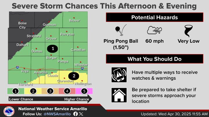
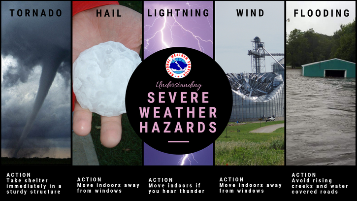
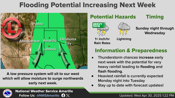
Severe thunderstorms are expected today and Friday from the upper Midwest, central Great Lakes into the Ohio and mid-Mississippi Valley's. In addition, heavy rainfall threat increases on Friday across the Ohio Valley. Meanwhile, early summer-like heat wave across portions of southern Texas with new daily records are forecast today and through the weekend; The heat spreads across the Gulf States. Read More >

Click a location below for detailed forecast.

Last Map Update: Fri, May 16, 2025 at 12:10:26 am CDT

We will be watching for a storm system to impact the Panhandles on Sunday. One of the main keys to the forecast will be where the dryline sets up because locations west of the dryline will likely have breezy to windy conditions, but those east of the dryline will have a chance for strong to severe thunderstorms.
We'll be above normal with our temperatures over the weekend, with several areas expected to reach the low 90s on Sunday.
Lows tonight will be in the mid-40s to mid-50s with winds generally less than 10 mph.
Overall temperatures are favored to be above normal for the 6 to 10 day outlook, and while equal chances are out there for precipitation, it's worth noting that most of the guidance is giving very little to no precipitation to the Panhandles (exception is the eastern Panhandles) over the next 10 days. There may be a pattern chance that start to support moisture return in the 10 to 14 day time frame, but right now it's looking mostly dry.

Text Product Selector (Selected product opens in current window)


Current Observations ( )
Location Sky/Weather Temp (°F) Dewpt (°F) RH (%) Wind (mph) Pressure (inHg) Remarks
 Amarillo
N/A
N/A
N/A
N/A
N/A
N/A
N/A
 Borger
N/A
N/A
N/A
N/A
N/A
N/A
N/A
 Canadian
N/A
N/A
N/A
N/A
N/A
N/A
N/A
 Dalhart
N/A
N/A
N/A
N/A
N/A
N/A
N/A
 Dumas
N/A
N/A
N/A
N/A
N/A
N/A
N/A
 Guymon
N/A
N/A
N/A
N/A
N/A
N/A
N/A
 Hereford
N/A
N/A
N/A
N/A
N/A
N/A
N/A
 Pampa
N/A
N/A
N/A
N/A
N/A
N/A
N/A
 Perryton
N/A
N/A
N/A
N/A
N/A
N/A
N/A
 Amarillo 9NNE
N/A
N/A
N/A
N/A
N/A
N/A
N/A
 Amarillo 7SSE
N/A
N/A
N/A
N/A
N/A
N/A
N/A
 Bootleg 11WNW
N/A
N/A
N/A
N/A
N/A
N/A
N/A
 Canadian 6E
N/A
N/A
N/A
N/A
N/A
N/A
N/A
 Clarendon 2WSW
N/A
N/A
N/A
N/A
N/A
N/A
N/A
 Claude 12SW
N/A
N/A
N/A
N/A
N/A
N/A
N/A
 Hereford 2NW
N/A
N/A
N/A
N/A
N/A
N/A
N/A
 McLean 1E
N/A
N/A
N/A
N/A
N/A
N/A
N/A
 Palo Duro SP
N/A
N/A
N/A
N/A
N/A
N/A
N/A
 Pampa 2E
N/A
N/A
N/A
N/A
N/A
N/A
N/A
 Umbarger 3NNE
N/A
N/A
N/A
N/A
N/A
N/A
N/A
Note: "N/A" or "MISG" will be displayed if values are not available. In the LOCATION column, click on links for a list of recent observations at sites of interest. In the WIND column, VRB is "variable" and G is "gust". In the REMARKS column, HX is "heat index", WCI is "wind chill index", and VSB is "visibility" (if shown).


Aviation Drought Fire Weather Hydrology Severe Weather Winter Weather
 
Climate Graphs Hourly Forecast Long Range Local Model Data Precip Maps Office Webcam
 
Education Local Research News Skywarn Weather Calculator Weather Radio