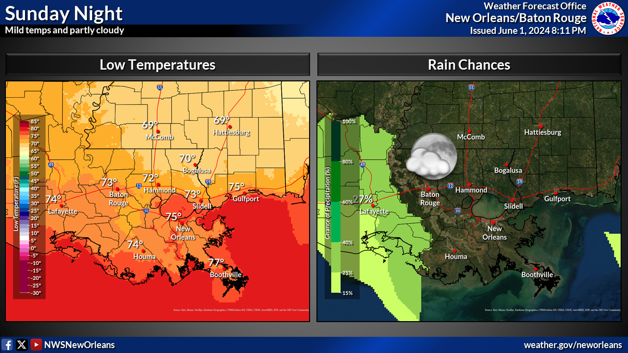
National Weather Service United States Department of Commerce

Severe Weather Threat Shifted to the Southern Plains and Mid-South; Critical Fire Weather in the Southern Plains

Multiple rounds of strong to severe thunderstorms may produce very large hail, swaths of damaging wind, a few tornadoes and heavy rain across parts of Texas into the lower Mississippi and Tennessee Valleys. Gusty winds and dry conditions will continue to promote elevated to critical fire weather conditions across the southern High Plains. Read More >

Click a location below for detailed forecast.

Last Map Update: Tue, Apr 28, 2026 at 8:40:13 am CDT

There are no watches, warnings, or advisories at this time.

Graphic reads Mid-Week Rain and Cool-Down and displays forecasts for Tuesday through Thursday including High/Low temperatures and precipitation chances for New Orleans, Baton Rouge, Gulfport, and McComb. Temperatures range from overnight lows around 70 and highs in the mid to upper 80s (91 at Baton Rouge) for Tuesday and Wednesday, cooling to the upper 60s to around 80 on Thursday. Rain chances are very low, if any Tuesday and Wednesday climbing to 40-60% on Thursday.


CoCoRaHS
CoCoRaHS - Click for more information
Submit
Storm Report

Submit a Storm Report

River Stages
Latest River Stages


Quick Access to Text Products


 Current Weather Observations...
Location Time
(CDT)
Weather Vsby.
(SM)
Temp.
(ºF)
Dewpt.
(ºF)
Hum.
(%)
Wind
(mph)
Wind Chill / Heat Index
(ºF)
Pres.
(in)
Baton Rouge LA07:53Partly Cloudy10747190ESE 6-30.04
Biloxi MS08:09Mostly Clear10777183S 5-30.05
Gulfport MS07:53Mostly Clear10777078SSE 9-30.07
Hammond LA08:15Partly Cloudy10767390SSE 9-30.06
Houma LA07:47Partly Cloudy7777183SSW 5-30.07
McComb MS08:29Partly Cloudy10737090SSE 13-30.05
New Orleans LA07:53Mostly Cloudy10767184E 5-30.07
Slidell La08:16Partly Cloudy10757290SSE 5-30.07