Overview
|
On the evening of April 2, 2025, a few discrete cells that eventually merged into a line of strong to severe storms swept through the area after sunset. Damaging winds of 60-80 mph were the main threat along with a few tornadoes. Concentrated areas of wind damage were noted across northern Indiana and northwest Ohio. As of April 5th, 2025, NWS Storm Surveys have confirmed 8 tornadoes: an EF-1 in Marshall County near Bourbon, 2 EF-1 tornadoes in Adams County, IN, 2 EF-1 tornadoes in Van Wert County, OH, an EF-1 tornado in Steuben County, an EF-1 in Branch County, MI, and an EF-2 tornado that affected Paulding/Putnam Counties in northwest Ohio. These storms also brought heavy rain to the area, with 1-3"+ area-wide, which escalated concerns for areal and river flooding for several days afterwards. Here's the link to the most recent PNS: https://partnerservices.nws.noaa.gov/products/adb9f96762b2775d6ef37cb705cb4a39 |
Tornadoes
Select a tornado from the table to zoom into the track and view more information. The default table view is limited to 8 tracks, but can be scrolled by a mouse wheel or dynamically expanded. Additionally, the table can fill the entire window by clicking the small circular expanding arrow icon at the very top right of the table and returned to its original size by clicking the button again. The side information panel that opens over the map can be closed using the "X" on the upper right corner of the pop-up. Zoom into the map and click damage points to see detailed information and pictures from the surveys.
|
NOTE: times shown below are local to your device's time zone. |

The Enhanced Fujita (EF) Scale classifies tornadoes into the following categories:
| EF0 Weak 65-85 mph |
EF1 Moderate 86-110 mph |
EF2 Significant 111-135 mph |
EF3 Severe 136-165 mph |
EF4 Extreme 166-200 mph |
EF5 Catastrophic 200+ mph |
 |
|||||
| Tornadoes that fail to impact any ratable structures on the EF-Scale are rated EF-Unknown (EF-U) | |||||
Peak Wind Gusts
Here is a summary of peak wind gusts from the evening of April 2nd:
137
NOUS43 KIWX 031258
PNSIWX
INZ005>009-012>015-017-018-020-022>027-032>034-103-104-116-203-204-216-MIZ078>081-
177-277-OHZ001-002-004-005-015-016-024-025-040058-

Public Information Statement
National Weather Service Northern Indiana
858 AM EDT Thu Apr 3 2025

...HIGHEST WIND REPORTS FROM APRIL 2, 2025...

Location                     Speed     Time/Date       Lat/Lon

...Indiana...

...Allen County...
Fort Wayne International Ap  53 MPH    1036 PM 04/02   40.98N/85.18W

...De Kalb County...
Auburn Dekalb C              40 MPH    1015 PM 04/02   41.30N/85.07W

...Elkhart County...
2 ESE Waterford Mills        70 MPH    0824 PM 04/02   41.53N/85.80W

...Grant County...
Grant County Municipal Apt   49 MPH    1015 PM 04/02   40.48N/85.68W

...Jay County...
Dunkirk                      62 MPH    1015 PM 04/02   40.37N/85.21W

...Kosciusko County...
2 N North Webster            52 MPH    0825 PM 04/02   41.35N/85.70W

...La Porte County...
La Porte                     41 MPH    0236 PM 04/02   41.57N/86.73W

...Miami County...
Grissom AFB Peru             45 MPH    0913 PM 04/02   40.63N/86.15W

...Starke County...
Knox - Starke Co. Airport    53 MPH    0735 PM 04/02   41.33N/86.67W

...Steuben County...
Orland                       98 MPH    0848 PM 04/02   41.73N/85.17W

...Whitley County...
Northeast Purdue Agricultura 43 MPH    1005 PM 04/02   41.11N/85.40W

...Michigan...

...Berrien County...
Benton Harbor                46 MPH    0935 AM 04/02   42.13N/86.42W

...Ohio...

...Allen County...
2 WNW Westminster            63 MPH    1122 PM 04/02   40.71N/84.02W
Lima 1 N                     49 MPH    1129 PM 04/02   40.78N/84.12W
Bluffton                     42 MPH    1145 PM 04/02   40.89N/83.89W

...Defiance County...
Defiance                     46 MPH    0128 AM 04/03   41.33N/84.43W

...Fulton County...
Wauseon                      40 MPH    1235 AM 04/03   41.62N/84.13W

...Henry County...
DESHLER                      56 MPH    1145 PM 04/02   41.20N/83.89W

...Putnam County...
Ottawa                       68 MPH    1233 AM 04/03   41.03N/83.98W
Kalida                       40 MPH    1130 PM 04/02   40.98N/84.20W

...Van Wert County...
1 SSW Van Wert               65 MPH    1107 PM 04/02   40.86N/84.59W
Middle Point                 50 MPH    1124 PM 04/02   40.86N/84.45W
Van Wert                     45 MPH    1110 PM 04/02   40.85N/84.48W
Van Wert County              40 MPH    1115 PM 04/02   40.87N/84.62W

Observations are collected from a variety of sources with varying
equipment and exposures. We thank all volunteer weather observers
for their dedication. Not all data listed are considered official.
Storm Reports
Preliminary Local Storm Report...Summary
National Weather Service Northern Indiana
1243 AM EDT Fri Apr 4 2025

..TIME...   ...EVENT...      ...CITY LOCATION...     ...LAT.LON...
..DATE...   ....MAG....      ..COUNTY LOCATION..ST.. ...SOURCE....
            ..REMARKS..

0730 PM     Hail             1 S Brems               41.32N 86.70W
04/02/2025  M0.75 Inch       Starke             IN   Trained Spotter

            Trained Spotter reports dime to penny sized
            hail just south of Brems in Starke County in
            Indiana. Also reported 35 to 45 mph gusts.

0735 PM     Non-Tstm Wnd Gst 2 ESE Brems             41.33N 86.67W
04/02/2025  M53 MPH          Starke             IN   AWOS

            AWOS station KOXI Knox - Starke Co. Airport.

0752 PM     Tornado          1 SSE Rutland           41.23N 86.35W
04/02/2025                   Marshall           IN   NWS Storm Survey

            A survey of damage revealed a tornado
            touched down southeast of Rutland on SR-10
            and tracked quickly northeast. The tornado
            moved over numerous empty fields but also
            impacted several wooded areas as well as
            snapped or uprooted trees on private
            property. The tornado entered Bourbon and
            reached peak intensity on the northeast side
            of town in the area of Crocus Ct and Rose
            Lane where several homes suffered extensive
            roof damage. Debris was thrown into the
            field. Many homes showed garage doors being
            compromised, lowering potentially higher
            wind speeds. The tornado continued out of
            town, producing sporadic tree and power pole
            damage until reaching north of Etna Green in
            Kosciusko county where the damage ended. A
            preliminary rating of the tornado has been
            assigned EF-1 with estimated peak winds
            around 105 mph. The path length was 17.9
            miles.

0754 PM     Tstm Wnd Dmg     1 SE Rutland            41.23N 86.34W
04/02/2025                   Marshall           IN   Broadcast Media

            Roof damage to a barn on IN-10 between
            Culver and Argos. Photo relayed by ABC 57 on
            Facebook. Time estimated via radar.

0754 PM     Tstm Wnd Dmg     2 E Rutland             41.24N 86.31W
04/02/2025                   Marshall           IN   Utility Company

            Marshall County REMC reports nearly a mile
            swath of 3 phase power poles and lines down
            on State Road 10 between Argos and Culver
            and on the south side of Lake Max. Time
            estimated via radar.

0756 PM     Tstm Wnd Dmg     Clymers                 40.71N 86.45W
04/02/2025                   Cass               IN   Emergency Mngr

            Tree down onto a garage. Time estimated via
            radar.

0800 PM     Tstm Wnd Dmg     2 ESE Rutland           41.24N 86.33W
04/02/2025                   Marshall           IN   Public

            Lots of damage reported east of Argos, IN on
            SR 10 including trees down onto powerlines
            and large trees limbs snapped.

0801 PM     Tstm Wnd Dmg     2 NE Logansport         40.77N 86.34W
04/02/2025                   Cass               IN   Emergency Mngr

            Emergency manager relayed a report of a tree
            down on Hawthorne Lane in Logansport. Time
            estimated via radar.

0803 PM     Tstm Wnd Dmg     Bourbon                 41.29N 86.12W
04/02/2025                   Marshall           IN   Broadcast Media

            Photo relayed by WSBT in South Bend of
            damage to the Northern Indiana Manufacturing
            factory in Bourbon. Factory is at the
            intersection of W Quad Street and S Ecker
            Avenue. Time estimated via radar.

0803 PM     Tstm Wnd Dmg     Bourbon                 41.29N 86.12W
04/02/2025                   Marshall           IN   Broadcast Media

            Photo relayed by WSBT of damage to Northern
            Indiana Manufacturing Inc. The factory is at
            the intersection of S Ecker Avenue and W
            Quad Street. Time estimated via radar.

0804 PM     Tstm Wnd Dmg     1 N Bourbon             41.31N 86.12W
04/02/2025                   Marshall           IN   Broadcast Media

            ABC 57 in South Bend relays report that 3
            semis tipped over on US 30 in Bourbon. Parts
            of US 30 are closed. Unknown if any
            injuries. Time estimated via radar.

0804 PM     Tstm Wnd Dmg     2 E Bourbon             41.30N 86.08W
04/02/2025                   Marshall           IN   Amateur Radio

            Structural damage reported to a house on the
            east side of Bourbon. Time estimated via
            radar.

0804 PM     Tstm Wnd Dmg     Bourbon                 41.30N 86.12W
04/02/2025                   Marshall           IN   Broadcast Media

            Roof gone and structural damage to the
            Bourbon Township Trustee building at the
            intersection of Center Street and N
            Washington Street. Relayed by ABC 57. Time
            estimated via radar.

0805 PM     Tstm Wnd Dmg     Bourbon                 41.30N 86.12W
04/02/2025                   Marshall           IN   Broadcast Media

            Substantial damage to a home in Bourbon.
            Garage is completely gone and part of home
            has severe structural damage. Time estimated
            via radar.

0805 PM     Tstm Wnd Dmg     2 ENE Bourbon           41.30N 86.09W
04/02/2025                   Marshall           IN   Utility Company

            Marshall County REMC reports over 20 broken
            poles along 12th Rd between Cedar Rd and
            Beech Rd. Time estimated via radar.

0805 PM     Tstm Wnd Dmg     1 N Bourbon             41.31N 86.12W
04/02/2025                   Marshall           IN   Broadcast Media

            US 30 was closed for several hours on the
            evening of April 2nd after at least 3 semis
            flipped over at the intersection with Cedar
            Rd north of Bourbon. Unknown if there were
            any injuries. US 30 was closed from US 331
            to SR 19. Time estimated via radar.

0809 PM     Tstm Wnd Dmg     3 N Etna Green          41.32N 86.04W
04/02/2025                   Kosciusko          IN   Emergency Mngr

            Powerlines down on SR19 near 600 North. Time
            estimated via radar.

0825 PM     Tstm Wnd Dmg     1 NW Syracuse           41.43N 85.76W
04/02/2025                   Kosciusko          IN   Emergency Mngr

            Tree and power lines down onto a vehicle
            across N. Hillside Drive. Time estimated via
            radar.

0830 PM     Tstm Wnd Dmg     2 WSW Scott             41.73N 85.60W
04/02/2025                   Lagrange           IN   Emergency Mngr

            Multiple trees down onto powerlines at the
            intersection of St Rd 120 and 900 West. Time
            estimated via radar.

0837 PM     Tstm Wnd Dmg     3 N Mongo               41.72N 85.24W
04/02/2025                   Lagrange           IN   Law Enforcement

            LaGrange County Sheriffs Office reports
            leaning/downed power lines on SR 120 between
            CR 110 E and CR 900 E. Time estimated via
            radar.

0848 PM     Tstm Wnd Dmg     Orland                  41.73N 85.17W
04/02/2025                   Steuben            IN   Emergency Mngr

            Emergency manager reports a barn with
            structural damage to the roof at 7640 N 750
            W ij Orland. Time estimated via radar.

0848 PM     Tstm Wnd Dmg     Orland                  41.73N 85.17W
04/02/2025                   Steuben            IN   Trained Spotter

            Damage reported to a barn and a home on St
            Rd 120. Time estimated via radar.

0848 PM     Tstm Wnd Dmg     Orland                  41.73N 85.17W
04/02/2025                   Steuben            IN   Emergency Mngr

            Emergency manager reports 1 injury at 6060
            Market Street in Orland. Roof lost on a 1
            story assisted living building. Insulation
            and debris strewn in nearby fields and in
            trees. Time estimated via radar.

0855 PM     Tstm Wnd Dmg     1 SSW Lake of the Woods 41.83N 85.05W
04/02/2025                   Branch             MI   Trained Spotter

            Large trees downed and extensive damage to a
            shed was reported. Time estimated from
            radar.

0945 PM     Flood            North Webster           41.33N 85.70W
04/02/2025                   Kosciusko          IN   NWS Employee

            NWS Employee reports water covering CR13 in
            North Webster. Estimated water to be at
            least 6 inches deep.

1005 PM     Tstm Wnd Dmg     1 WSW Mill Grove        40.40N 85.30W
04/02/2025                   Blackford          IN   Public

            Report of a home with serious damage on CR
            400 E between CR 300 S and CR 400 S. Time
            estimated from radar.

1006 PM     Tstm Wnd Dmg     1 WSW Mill Grove        40.40N 85.30W
04/02/2025                   Blackford          IN   Law Enforcement

            *** 1 INJ ***
            Corrects previous tstm wnd dmg report from 1
            WSW Mill Grove. Law Enforcement reported a
            barn was blown into a house near Mill Grove
            in Blackford County in Indiana. Time is
            radar estimated. 1 minor injury was
            reported.

1008 PM     Tstm Wnd Dmg     2 WSW Mill Grove        40.40N 85.31W
04/02/2025                   Blackford          IN   Law Enforcement

            Law enforcement reports of a large tree
            downed near Mill Grove in Blackford County
            in Indiana. Time is radar estimated.

1023 PM     Tstm Wnd Dmg     1 SW Collett            40.36N 85.02W
04/02/2025                   Jay                IN   Emergency Mngr

            Tree onto a house near 550 S and 200 W. No
            injuries reported. Time estimated by radar.

1024 PM     Tstm Wnd Dmg     2 N Redkey              40.38N 85.15W
04/02/2025                   Jay                IN   Emergency Mngr

            Emergency manager reports powerlines down
            and trees down at 400 S and State Road 1
            north of Redkey.

1027 PM     Tstm Wnd Dmg     2 SE New Mount Pleasant 40.34N 85.04W
04/02/2025                   Jay                IN   Emergency Mngr

            Emergency manager reports roof damage to
            barns, silos, and machine sheds east of
            Redkey on S CR 325 W. Debris scattered in a
            nearby field. Time estimated via radar.

1036 PM     Tstm Wnd Gst     2 ENE Nine Mile         40.98N 85.18W
04/02/2025  M53 MPH          Allen              IN   ASOS

            Corrects previous tstm wnd gst report from 2
            ENE Nine Mile. ASOS station KFWA Fort Wayne
            International Ap.

1042 PM     Tstm Wnd Dmg     Berne                   40.66N 84.96W
04/02/2025                   Adams              IN   Trained Spotter

            Trained spotter reported a large tree downed
            in Berne in Adams County in Indiana.

1100 PM     Tstm Wnd Dmg     1 ESE Glenmore          40.78N 84.68W
04/02/2025                   Van Wert           OH   Emergency Mngr

            Barn destroyed at 7225 Ainsworth Road in
            Ohio City, OH. Time estimated via radar.

1100 PM     Tstm Wnd Dmg     Ohio City               40.77N 84.62W
04/02/2025                   Van Wert           OH   Emergency Mngr

            Village of Ohio City Fire Dept reporting
            some poles snapped and some trees down on
            west side of town.

1104 PM     Tornado          2 ESE Van Wert          40.85N 84.55W
04/02/2025                   Van Wert           OH   NWS Storm Survey

            A tornado touched down on the southeast side
            of Van Wert, OH where tree and shingle
            damage occurred before the tornado destroyed
            a two-story barn structure. The tornado
            might have briefly skipped as it traversed
            to the northeast before causing noticeable
            damage on Lincoln Hwy. The tornado then
            caused some minor damage to a deer farm
            before destroying a pole barn. The last
            noticeable damage occurred just northwest of
            Ottoville. As this tornado dissipated,
            another tornado formed off just to its
            north. The tornado has been given a
            preliminary rating of EF-1 with an estimated
            peak wind of 95 mph. Path length is 12.6
            miles and maximum path width of 300 yards.

1110 PM     Tstm Wnd Dmg     2 ESE Van Wert          40.85N 84.55W
04/02/2025                   Van Wert           OH   Public

            Photos on X of power poles and tree branches
            down. A home lost its roof at the corner of
            Jennings Rd and Mendon Rd. Time estimated
            via radar.

1111 PM     Tstm Wnd Dmg     Middle Point            40.85N 84.45W
04/02/2025                   Van Wert           OH   Trained Spotter

            Tree branches reported down.

1111 PM     Tstm Wnd Dmg     Middle Point            40.85N 84.45W
04/02/2025                   Van Wert           OH   Trained Spotter

            Tree branches reported down.

1112 PM     Tstm Wnd Dmg     Dupont                  41.06N 84.30W
04/02/2025                   Putnam             OH   Emergency Mngr

            Several homes with extensive damage in
            Dupont, OH.

1112 PM     Tstm Wnd Dmg     Dupont                  41.06N 84.30W
04/02/2025                   Putnam             OH   Emergency Mngr

            Several homes with extensive damage in
            Dupont, OH.

1112 PM     Tstm Wnd Dmg     1 ENE Dupont            41.06N 84.29W
04/02/2025                   Putnam             OH   Emergency Mngr

            Mobile home rolled several times in the
            22000 block of county road I-22. 3 injuries
            reported. Time estimated via radar.

1112 PM     Tstm Wnd Dmg     Middle Point            40.86N 84.45W
04/02/2025                   Van Wert           OH   Emergency Mngr

            Report of several trees uprooted at Mendon
            Rd and Middle Point Rd.

1113 PM     Tstm Wnd Dmg     Dupont                  41.06N 84.30W
04/02/2025                   Putnam             OH   Emergency Mngr

            Large tree down on a house in Dupont, OH.
            Time estimated via radar.

1115 PM     Tstm Wnd Dmg     1 SSW Ottoville         40.92N 84.34W
04/02/2025                   Putnam             OH   Emergency Mngr

            Part of a barn was reported in the roadway
            on SR 66 , south of Ottoville.

1118 PM     Tornado          1 NE Mandale            41.03N 84.35W
04/02/2025                   Paulding           OH   NWS Storm Survey

            A second tornado spun up north of the
            decaying Van Wert tornado, touching down in
            far southeast Paulding County. The tornado
            severely damaged a pole barn as it moved
            into Putnam county. The tornado rapidly
            moved northeast, hitting a well anchored
            mobile homed and flipping it 60 feet away.
            Three occupants were in the mobile home and
            two of them sustained minor injuries. It is
            here that the tornado peaked at EF-2
            magnitude with an estimated wind speed of
            120 mph. The tornado destroyed another
            well-anchored 60x120 ft pole barn, throwing
            its debris onto the bank of the Auglaize
            River. To the northeast, it directly hit the
            town of Dupont where it did widespread EF-0
            to EF-1 damage throughout. The tornado
            damaged several large corn silos (one that
            was full of corn had the ground anchor bolts
            break from uplift). It is near here where
            the visible damage stopped. The path length
            of the tornado is 4.51 miles with a maximum
            width of 375 yards.

0600 AM     Flood            3 W Delta               41.57N 84.06W
04/03/2025                   Fulton             OH   Dept of Highways

            OH DOT reports US 20A in Delta is closed due
            to flooding as of 6 AM April 3rd.

0800 AM     Rain             Malinta                 41.32N 84.04W
04/03/2025  M5.60 Inch       Henry              OH   Emergency Mngr

            Photo of a rain gauge with 5.6 inches of
            rain in the past 24 hours per emergency
            manager.


&&

$$
Rain Reports
New daily rainfall records were set at both Fort Wayne (KFWA) and South Bend (KSBN) on April 2nd.
Fort Wayne had 1.51"of rain, which broke the previous daily record of 0.83" set in 1983. South Bend
had 1.41" of rain, which broke the previous daily record of 1.07" set in 1975. This was the first
time KFWA had received 1" or more of rain in a single day since May 7, 2024, which was 330 days ago!

Public Information Statement
National Weather Service Northern Indiana
1005 AM EDT Thu Apr 3 2025

...24 HOUR RAINFALL REPORTS...

Location                     Amount    Time/Date       Lat/Lon

...Indiana...

...Adams County...
0.8 N Linn Grove             1.13 in   0945 AM 04/03   40.66N/85.03W

...Allen County...
Fort Wayne 9.3 W             2.07 in   0700 AM 04/03   41.05N/85.31W
Monroeville 0.2 ESE          2.03 in   0700 AM 04/03   40.97N/84.86W
Fort Wayne 9.1 SE            1.96 in   0700 AM 04/03   40.99N/85.00W
Woodburn 2.8 WSW             1.96 in   0700 AM 04/03   41.12N/84.91W
Hoagland 1.5 SSW             1.89 in   0700 AM 04/03   40.93N/85.00W
Fort Wayne 8.0 N             1.80 in   0700 AM 04/03   41.19N/85.11W
Fort Wayne 6.8 NE            1.68 in   0700 AM 04/03   41.13N/85.03W
Ellisville 0.3 W             1.45 in   0730 AM 04/03   41.02N/85.29W
Fort Wayne 6.0 N             1.44 in   0700 AM 04/03   41.16N/85.13W
Fort Wayne 2.6 NW            1.41 in   0700 AM 04/03   41.10N/85.18W
Fort Wayne 8.7 W             1.40 in   0700 AM 04/03   41.08N/85.31W
Woodburn 2.6 NNW             1.39 in   0900 AM 04/03   41.16N/84.88W
Fort Wayne 2.6 NE            1.21 in   0700 AM 04/03   41.10N/85.11W
4 S Tuckers Corner           1.21 in   0950 AM 04/03   40.99N/84.94W
Fort Wayne 4.1 NE            1.03 in   0700 AM 04/03   41.12N/85.09W
Fort Wayne 1.9 SSW           1.00 in   0700 AM 04/03   41.05N/85.15W
SPENCERVILLE                 0.75 in   0945 AM 04/03   41.25N/84.89W
Fort Wayne 1.6 S             0.14 in   0800 AM 04/03   41.05N/85.14W

...Blackford County...
Hartford City 4 ESE          1.41 in   0800 AM 04/03   40.44N/85.29W

...Cass County...
Young America                0.75 in   0800 AM 04/03   40.57N/86.33W
Galveston                    0.58 in   0945 AM 04/03   40.56N/86.19W

...De Kalb County...
0.6 S Garrett                2.17 in   0610 AM 04/03   41.34N/85.13W
Hamilton 3.0 ESE             1.94 in   0700 AM 04/03   41.52N/84.86W
Corunna 1.1 S                1.72 in   0700 AM 04/03   41.42N/85.15W
Auburn 1.1 NNE               1.70 in   0700 AM 04/03   41.38N/85.05W
1.7 SE Butler                1.50 in   0725 AM 04/03   41.41N/84.85W
Auburn 0.4 NNW               1.29 in   0700 AM 04/03   41.37N/85.06W

...Elkhart County...
Syracuse 2.0 NW              1.99 in   0655 AM 04/03   41.44N/85.78W
Elkhart 4.8 SW               1.67 in   0600 AM 04/03   41.64N/86.04W
Goshen 1.8 SE                1.65 in   0700 AM 04/03   41.56N/85.81W
Ligonier 4.3 WNW             1.55 in   0800 AM 04/03   41.48N/85.67W
Wakarusa 2.4 NNE             1.53 in   0700 AM 04/03   41.57N/85.99W
Goshen 1.4 SSE               1.44 in   0700 AM 04/03   41.56N/85.83W
Goshen 1.2 SW                1.42 in   0700 AM 04/03   41.57N/85.85W
Goshen 4.6 N                 1.26 in   0700 AM 04/03   41.64N/85.83W
Goshen 3.5 NNW               1.25 in   0700 AM 04/03   41.62N/85.87W
Goshen 6.8 NE                1.00 in   0700 AM 04/03   41.65N/85.75W
Jamestown                    0.93 in   0930 AM 04/03   41.64N/86.04W
Goshen                       0.10 in   0953 AM 04/03   41.53N/85.78W

...Fulton County...
Rochester 2.4 NW             0.92 in   0700 AM 04/03   41.09N/86.23W
Rochester                    0.86 in   0700 AM 04/03   41.07N/86.21W
Kewanna 4.9 S                0.77 in   0700 AM 04/03   40.95N/86.41W

...Grant County...
(KB9CRA)Gas City 0.3 N       1.56 in   0700 AM 04/03   40.49N/85.61W
(KC9QCJ) Shamrock Lakes 3.0  1.38 in   0700 AM 04/03   40.45N/85.45W
2.2 N Marion                 0.91 in   0701 AM 04/03   40.58N/85.66W
Marion 5.6 NE                0.87 in   0600 AM 04/03   40.60N/85.59W
Upland 2.4 SSE               0.80 in   0700 AM 04/03   40.43N/85.50W
Marion 6.5 N                 0.79 in   0700 AM 04/03   40.64N/85.69W

...Huntington County...
Huntington 0.3 W             1.35 in   0700 AM 04/03   40.88N/85.51W
2.4 NW Warren                0.80 in   0945 AM 04/03   40.71N/85.45W
1.7 E Bowerstown             0.29 in   0900 AM 04/03   40.90N/85.41W

...Jay County...
(W9JKL) Portland 0.6 SSW     1.00 in   0700 AM 04/03   40.42N/84.99W
Portland 2.3 S               0.98 in   0700 AM 04/03   40.40N/84.98W
Redkey 0.6 SE                0.84 in   0801 AM 04/03   40.34N/85.14W

...Kosciusko County...
Cromwell 2.9 W               2.71 in   0700 AM 04/03   41.40N/85.67W
Syracuse 3.0 ESE             2.24 in   0800 AM 04/03   41.41N/85.70W
Milford 2.7 SSW              2.18 in   0600 AM 04/03   41.38N/85.87W
Leesburg 6.7 ESE             1.82 in   0700 AM 04/03   41.31N/85.72W
Leesburg 0.1 WNW             1.69 in   0600 AM 04/03   41.33N/85.85W
Warsaw 1.4 N                 1.68 in   0630 AM 04/03   41.26N/85.85W
Milford 0.9 N                1.67 in   0700 AM 04/03   41.42N/85.85W
Warsaw 1.2 NNE               1.53 in   0700 AM 04/03   41.25N/85.84W
North Webster 2.3 N          1.41 in   0800 AM 04/03   41.36N/85.70W
Warsaw 3.7 E                 1.19 in   0730 AM 04/03   41.23N/85.78W
North Webster 0.6 ESE        1.05 in   0800 AM 04/03   41.32N/85.69W
1 SSE Clunette               0.11 in   0950 AM 04/03   41.31N/85.92W

...La Porte County...
0.8 W La Porte               1.07 in   1258 AM 04/03   41.61N/86.73W
La Crosse 1.2 W              0.66 in   0800 AM 04/03   41.32N/86.91W
Hanna 1.1 E                  0.63 in   0800 AM 04/03   41.41N/86.76W
Mill Creek 1.9 NNE           0.54 in   0800 AM 04/03   41.61N/86.52W
La Porte 0.9 SSE             0.50 in   0800 AM 04/03   41.60N/86.71W
La Porte 1.6 SW              0.46 in   0800 AM 04/03   41.59N/86.73W
La Porte 6.8 SW              0.44 in   0800 AM 04/03   41.55N/86.82W
New Carlisle 3.0 WNW         0.25 in   0900 AM 04/03   41.72N/86.57W

...Lagrange County...
Orland 6.6 SSW               2.87 in   0700 AM 04/03   41.64N/85.20W
Lagrange 9.6 ESE             2.80 in   0700 AM 04/03   41.59N/85.24W
LaGrange 9.9 E               2.26 in   0800 AM 04/03   41.65N/85.23W
Wolcottville 1.1 WNW         2.13 in   0700 AM 04/03   41.53N/85.39W
LaGrange 1.3 ENE             1.61 in   0605 AM 04/03   41.65N/85.40W
Howe 3.7 WSW                 1.12 in   0700 AM 04/03   41.70N/85.48W

...Marshall County...
Culver 1.0 NNW               1.46 in   0700 AM 04/03   41.23N/86.43W
Plymouth 2.5 WSW             0.81 in   0400 AM 04/03   41.33N/86.36W
1.2 W Plymouth               0.72 in   0945 AM 04/03   41.34N/86.34W

...Miami County...
Denver 1.3 NE                0.79 in   0700 AM 04/03   40.88N/86.06W
Denver 0.5 SSE               0.78 in   0700 AM 04/03   40.86N/86.07W
Peru                         0.78 in   0930 AM 04/03   40.75N/86.07W
Amboy                        0.70 in   0945 AM 04/03   40.59N/85.98W
Macy 2.7 SSE                 0.41 in   0700 AM 04/03   40.92N/86.12W

...Noble County...
Huntertown 3.2 NW            2.50 in   0700 AM 04/03   41.27N/85.21W
Ligonier 5.3 ENE             2.02 in   0900 AM 04/03   41.49N/85.50W
Kendallville 4.5 NW          1.80 in   0700 AM 04/03   41.50N/85.31W
Cosperville                  1.40 in   0930 AM 04/03   41.48N/85.48W
Avilla 3 SW                  0.83 in   0600 AM 04/03   41.35N/85.30W

...Pulaski County...
Monterey 2.2 WNW             1.67 in   0800 AM 04/03   41.17N/86.52W
Francesville                 1.50 in   0700 AM 04/03   40.98N/86.89W
Winamac 9.9 NW               0.71 in   0800 AM 04/03   41.15N/86.75W
1.3 SW Ora                   0.49 in   0945 AM 04/03   41.16N/86.56W

...St. Joseph County...
South Bend 3.3 SE            1.71 in   0600 AM 04/03   41.64N/86.23W
Mishawaka 3.9 ENE            1.67 in   0740 AM 04/03   41.68N/86.10W
Granger 1.8 ENE              1.59 in   0700 AM 04/03   41.75N/86.11W
South Bend 4.6 SE            0.99 in   0700 AM 04/03   41.62N/86.22W
Walkerton 4.1 ENE            0.96 in   0713 AM 04/03   41.49N/86.41W
New Carlisle                 0.68 in   0730 AM 04/03   41.71N/86.50W
0.9 W Roseland               0.34 in   0915 AM 04/03   41.72N/86.27W

...Starke County...
3.5 N Brems                  0.06 in   0900 AM 04/03   41.39N/86.71W

...Steuben County...
Angola                       2.70 in   0630 AM 04/03   41.64N/84.99W
Angola 6.2 NW                2.47 in   0700 AM 04/03   41.71N/85.07W
Hudson 4.1 NNW               2.32 in   0700 AM 04/03   41.59N/85.10W
Hudson 4.6 N                 2.19 in   0715 AM 04/03   41.60N/85.09W
Hudson 0.3 SE                2.08 in   0520 AM 04/03   41.53N/85.08W
Hamilton 1.7 E               1.92 in   0700 AM 04/03   41.53N/84.89W
Angola 8.7 ESE               1.76 in   0700 AM 04/03   41.61N/84.84W
Hudson 6.4 WNW               1.61 in   0800 AM 04/03   41.58N/85.19W
Angola 8.8 ESE               1.56 in   0800 AM 04/03   41.62N/84.83W
Angola 1.2 S                 1.30 in   0600 AM 04/03   41.62N/85.00W
0.7 E Hamilton               1.08 in   0945 AM 04/03   41.53N/84.90W

...Wabash County...
Wabash 0.3 NNW               1.64 in   0600 AM 04/03   40.80N/85.83W
0.7 SE Wabash                0.90 in   0930 AM 04/03   40.79N/85.82W
3.0 SE Lagro                 0.71 in   0915 AM 04/03   40.81N/85.68W

...Wells County...
Bluffton 0.9 SE              1.70 in   0700 AM 04/03   40.73N/85.16W
Craigville 2.7 NW            1.33 in   0800 AM 04/03   40.80N/85.13W
Bluffton                     1.08 in   0945 AM 04/03   40.74N/85.17W

...White County...
5.6 N Badger Grove           1.02 in   0600 AM 04/03   40.67N/86.95W
Brookston 0.3 SE             0.64 in   0700 AM 04/03   40.60N/86.86W
Idaville 0.2 SW              0.63 in   0700 AM 04/03   40.76N/86.65W
Monticello 5.5 NNW           0.63 in   0800 AM 04/03   40.82N/86.79W
Norway                       0.51 in   0845 AM 04/03   40.78N/86.76W

...Whitley County...
Columbia City 4.6 S          2.26 in   0600 AM 04/03   41.09N/85.47W
Columbia City 0.5 WSW        1.57 in   0615 AM 04/03   41.16N/85.49W
South Whitley 2.6 SE         1.53 in   0800 AM 04/03   41.06N/85.59W
Columbia City 0.2 NE         1.01 in   0639 AM 04/03   41.16N/85.48W
Tri-Lakes 3.0 N              0.78 in   0700 AM 04/03   41.26N/85.49W
Columbia City 7.4 N          0.76 in   0640 AM 04/03   41.26N/85.50W
Columbia City 5.4 N          0.75 in   0700 AM 04/03   41.24N/85.49W

...Michigan...

...Berrien County...
Stevensville 1.7 SSE         2.93 in   0522 AM 04/03   41.99N/86.51W
Baroda 1.3 W                 2.48 in   0700 AM 04/03   41.95N/86.51W
St. Joseph 2.8 SSE           2.29 in   0700 AM 04/03   42.06N/86.47W
Shoreham 2.0 SE              1.69 in   0800 AM 04/03   42.03N/86.49W
Buchanan 1.4 ESE             1.49 in   0700 AM 04/03   41.82N/86.34W
3.7 S Watervliet             1.20 in   0900 AM 04/03   42.13N/86.25W
St. Joseph 1.5 SSE           1.02 in   0700 AM 04/03   42.08N/86.48W
Niles 2.7 W                  1.02 in   0800 AM 04/03   41.84N/86.30W
Benton Harbor                0.87 in   0953 AM 04/03   42.13N/86.42W

...Branch County...
1 SSW Coldwater              0.71 in   0953 AM 04/03   41.92N/85.01W
Coldwater                    0.33 in   0855 AM 04/03   41.92N/85.03W

...Cass County...
Niles 3.5 E                  1.64 in   0600 AM 04/03   41.84N/86.18W
2 NNW Edwardsburg            1.46 in   0700 AM 04/03   41.84N/86.10W

...Hillsdale County...
Osseo 2.7 NE                 2.30 in   0830 AM 04/03   41.90N/84.49W
Hillsdale 2.5 ESE            2.18 in   0800 AM 04/03   41.91N/84.59W
Jonesville 5.9 ENE           1.97 in   0600 AM 04/03   42.01N/84.56W

...St. Joseph County...
Three Rivers 2.4 NE          2.29 in   0700 AM 04/03   41.97N/85.60W
2.0 SE Mendon                1.07 in   0900 AM 04/03   41.98N/85.43W

...Ohio...

...Allen County...
Delphos 2.3 ESE              1.46 in   0600 AM 04/03   40.83N/84.30W
Lima 2.7 NE                  1.46 in   0700 AM 04/03   40.77N/84.08W
Elida 1.4 WNW                1.43 in   0707 AM 04/03   40.80N/84.22W
Lima 7.3 SE                  1.28 in   0700 AM 04/03   40.66N/84.03W
Spencerville 0.3 SSE         1.15 in   0800 AM 04/03   40.70N/84.35W
Ada 3.0 W                    1.09 in   0855 AM 04/03   40.77N/83.88W
Lima 1 N                     0.95 in   0928 AM 04/03   40.78N/84.12W
2 WNW Westminster            0.91 in   0953 AM 04/03   40.71N/84.02W

...Defiance County...
Defiance                     1.63 in   0953 AM 04/03   41.33N/84.43W

...Fulton County...
Wauseon 1.8 S                2.30 in   0700 AM 04/03   41.53N/84.14W
Swanton 4.0 S                2.19 in   0642 AM 04/03   41.53N/83.91W
Fayette 4.3 ESE              1.94 in   0700 AM 04/03   41.65N/84.25W
Archbold 4.7 NW              1.83 in   0530 AM 04/03   41.57N/84.36W
Delta 0.4 ENE                1.80 in   0700 AM 04/03   41.58N/83.99W
Archbold 2.4 NW              1.25 in   0700 AM 04/03   41.54N/84.34W
4.6 SW Morenci  (R2)  (R2)   0.79 in   0900 AM 04/03   41.66N/84.25W

...Henry County...
Malinta                      5.60 in   0800 AM 04/03   41.32N/84.04W
New Bavaria 2.3 WSW          3.69 in   0700 AM 04/03   41.19N/84.21W
Napoleon 1.2 SSE             2.61 in   0700 AM 04/03   41.38N/84.12W
Napoleon 1 SW                2.57 in   0700 AM 04/03   41.38N/84.15W
Napoleon 0.6 WSW             2.46 in   0800 AM 04/03   41.39N/84.14W
Napoleon 4.5 NNW             1.95 in   0700 AM 04/03   41.46N/84.15W
DESHLER                      1.78 in   0930 AM 04/03   41.20N/83.89W

...Putnam County...
Ottawa 1.2 ENE               1.36 in   0855 AM 04/03   41.03N/84.02W
Ottawa 2.3 SE                1.33 in   0700 AM 04/03   40.99N/84.02W
Ottawa 1.0 N                 1.05 in   0700 AM 04/03   41.04N/84.04W

...Van Wert County...
2 N Wetsel                   1.40 in   0950 AM 04/03   40.98N/84.44W
1 WNW Convoy                 1.19 in   0950 AM 04/03   40.93N/84.74W

...Williams County...
Pioneer 2.3 S                2.24 in   0700 AM 04/03   41.65N/84.55W
1.2 E Bryan                  2.17 in   0800 AM 04/03   41.46N/84.53W
Alvordton 0.5 E              1.89 in   0700 AM 04/03   41.67N/84.42W
3 S Nettle Lake              0.98 in   0950 AM 04/03   41.63N/84.73W

Observations are collected from a variety of sources with varying
equipment and exposures. We thank all volunteer weather observers
for their dedication. Not all data listed are considered official.

$$
Photos & Video
Header
| Caption (source) |
Caption (source) |
Caption (source) |
Caption (source) |
Radar
Header
| Caption | Caption | Caption | Caption |
Environment
 |
 |
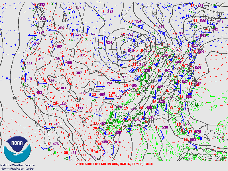 |
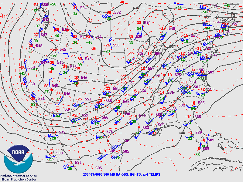
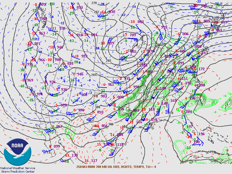
| Figure 1: 500 mb analysis April 2, 8 PM EDT | Figure 2: 700 mb analysis April 2, 8 PM EDT | Figure 3: 850 mb analysis April 2, 8 PM EDT |
Near-storm environment summary.
 |
 |
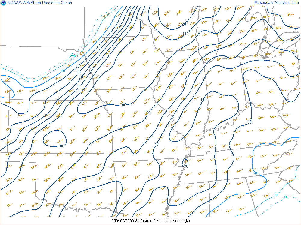 |
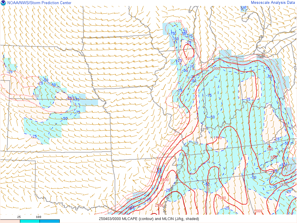
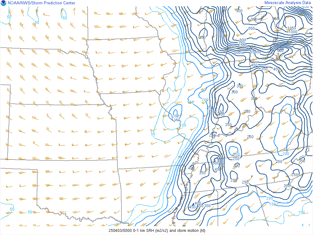
| Figure 4: 100 mb MLCAPE April 2, 8 PM EDT | Figure 5: 0-1 Storm Relative Helicity April 2, 8 PM EDT | Figure 6: 0-6km Deep Layer Shear April 2, 8 PM EDT |
Additional environmental data.
 |
 |
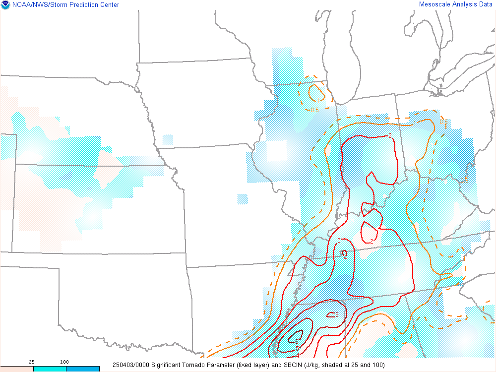 |
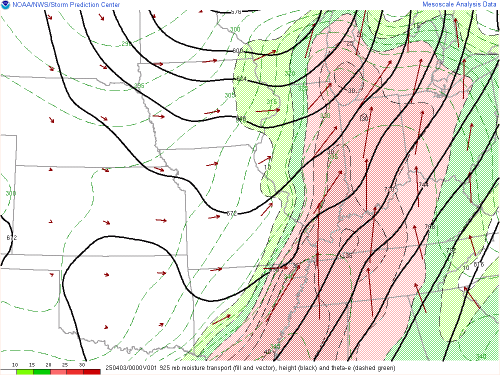
| Figure 7: Surface analysis April 2, 8 PM EDT | Figure 8: 925 mb Moisture Transport April 2, 8 PM EDT | Figure 9: Significant Tornado Parameter (STP) April 2, 8 PM EDT |
 |
Media use of NWS Web News Stories is encouraged! Please acknowledge the NWS as the source of any news information accessed from this site. |
|

