Overview
|
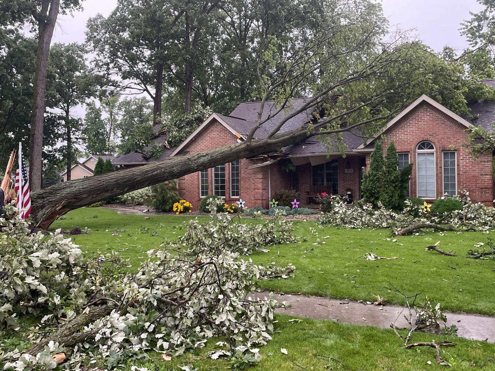
A line of strong to severe storms moved across the area in the afternoon and evening of Wednesday, June 18th, 2025. Overall, damage was generally confined to numerous instances of tree damage, scattered reports of power lines down, and some associated roof/siding damage to buildings/homes. Wind gusts were estimated to be between 50-60 mph. There were a few reports of quarter to golf ball size hail in northeast Indiana. The most extensive wind damage occurred in Van Wert County, OH; wind speeds of up to 70 mph downed an estimated 100 trees and caused minor damage to homes and buildings in the city of Van Wert. Van Wert County EMA director Rick McCoy said that this was the worst wind damage he had seen since the 2012 derecho. There were no injuries or fatalities. |
(Van Wert County EMA) |
Storm Reports
Preliminary Local Storm Report...Summary
National Weather Service Northern Indiana
358 PM EDT Thu Jun 19 2025
..TIME... ...EVENT... ...CITY LOCATION... ...LAT.LON...
..DATE... ....MAG.... ..COUNTY LOCATION..ST.. ...SOURCE....
..REMARKS..
0358 PM Tstm Wnd Dmg 4 SE Talma 41.10N 86.27W
06/18/2025 Fulton IN Public
Several large trees downed.
0415 PM Tstm Wnd Dmg 2 NW Gulivoire Park 41.63N 86.27W
06/18/2025 St. Joseph IN Trained Spotter
Large tree limbs down onto sheds on the
south side of South Bend. Time estimated via
radar.
0427 PM Tstm Wnd Dmg 2 S Stevensville 41.99N 86.52W
06/18/2025 Berrien MI Public
Large tree uprooted (estimated 12 to 18
inches in diameter) south of Stevensville.
Time estimated via radar.
0449 PM Tstm Wnd Gst 3 SSW La Porte 41.57N 86.73W
06/18/2025 M53 MPH La Porte IN AWOS
AWOS station KPPO La Porte.
0450 PM Hail South Whitley 41.08N 85.63W
06/18/2025 M1.00 Inch Whitley IN Broadcast Media
Photos of quarter size hail in South
Whitley. Tim estimated via radar.
0502 PM Tstm Wnd Dmg Paw Paw Lake 42.21N 86.28W
06/18/2025 Berrien MI Public
Large tree uprooted (estimated 1 to 2 feet
in diameter). Time estimated via radar.
0512 PM Tstm Wnd Gst Hanfield 40.60N 85.58W
06/18/2025 E60 MPH Grant IN Trained Spotter
Large limbs snapped.
0527 PM Tstm Wnd Dmg Bronson 41.87N 85.19W
06/18/2025 Branch MI Public
Large tree limbs snapped in Bronson. Time
estimated via radar.
0538 PM Tstm Wnd Gst 2 ENE Nine Mile 40.98N 85.18W
06/18/2025 M53 MPH Allen IN ASOS
ASOS station KFWA Fort Wayne International
Ap.
0545 PM Tstm Wnd Dmg Union City 42.07N 85.14W
06/18/2025 Branch MI Public
Large tree uprooted (estimated 2 to 3 feet
in diameter). Time estimated via radar.
0620 PM Tstm Wnd Dmg 1 NE Van Wert 40.88N 84.57W
06/18/2025 Van Wert OH Emergency Mngr
12 power poles down between Stripe Rd and
Mendon Rd near the Vantage Career Center.
Time estimated via radar.
0622 PM Tstm Wnd Dmg 1 E Van Wert 40.86N 84.57W
06/18/2025 Van Wert OH Public
Bell tower collapsed at St Marys Church in
Van Wert. Time estimated via radar.
0625 PM Tstm Wnd Gst 2 W Middle Point 40.85N 84.48W
06/18/2025 M62 MPH Van Wert OH Mesonet
Mesonet station AS860 Van Wert.
0640 PM Tstm Wnd Dmg 1 SW Kemp 40.71N 84.24W
06/18/2025 Allen OH Public
Powerlines down on SR 117 between
Spencerville and Lima.
0640 PM Tstm Wnd Dmg 1 SSE Delphos 40.84N 84.33W
06/18/2025 Allen OH Public
A large tree (2 to 3 feet in diameter) fell
on two homes in Delphos. Time estimated via
radar.
0641 PM Tstm Wnd Dmg 2 NE Kemp 40.74N 84.20W
06/18/2025 Allen OH Public
Tree down on West Elm Street at the
roundabout with South Fraunfeiter Rd. Time
estimated via radar.
0644 PM Tstm Wnd Dmg 1 WNW Lima 40.75N 84.13W
06/18/2025 Allen OH Public
Large tree down onto car at the intersection
of North Woodlawn Avenue and Latham Avenue.
No known injuries at this time. Time
estimated via radar.
0645 PM Tstm Wnd Dmg Lima 40.74N 84.11W
06/18/2025 Allen OH Broadcast Media
Large tree down on Woodlawn St. in Lima.
Time estimated via radar.
0645 PM Tstm Wnd Gst Lima 40.74N 84.11W
06/18/2025 E60 MPH Allen OH Trained Spotter
Trained spotter estimates gusts up to 60 mph
in Lima.
0647 PM Tstm Wnd Dmg 1 SW Lima 40.73N 84.13W
06/18/2025 Allen OH Trained Spotter
Corrects report source of previous tstm wnd
dmg report from 1 SW Lima. Trained spotter
reports large tree branches and a few trees
down near Faurot Park in Lima. Time
estimated via radar.
0350 PM Tstm Wnd Dmg 3 NW Dunkirk 40.79N 86.43W
06/18/2025 Cass IN Emergency Mngr
Multiple trees down.
0408 PM Tstm Wnd Dmg Argos 41.23N 86.25W
06/18/2025 Marshall IN Public
2 large trees down at Broadway St and 1st St
in Argos. Time estimated via radar.
0410 PM Tstm Wnd Gst 1 S Tippecanoe 41.20N 86.11W
06/18/2025 M62 MPH Marshall IN Public
Corrects previous tstm wnd gst report from 1
S Tippecanoe. Time estimated via radar.
0410 PM Tstm Wnd Dmg 2 WNW Mentone 41.19N 86.07W
06/18/2025 Marshall IN Public
Downed powerlines between Tippecanoe and
Mentone. Time estimated via radar.
0410 PM Tstm Wnd Dmg Argos 41.24N 86.24W
06/18/2025 Marshall IN Amateur Radio
Large limb down.
0415 PM Tstm Wnd Dmg 3 WNW South Bend 41.70N 86.32W
06/18/2025 St. Joseph IN ASOS
ASOS station KSBN South Bend International
Ap.
0417 PM Tstm Wnd Dmg 1 SSE Palestine 41.17N 85.95W
06/18/2025 Kosciusko IN Emergency Mngr
Tree down blocking road.
0418 PM Tstm Wnd Dmg 2 SSE South Bend 41.66N 86.25W
06/18/2025 St. Joseph IN Public
Minor damage to siding to a home on the
south side of South Bend. Time estimated via
radar.
0420 PM Tstm Wnd Dmg 1 SSE Atwood 41.25N 85.97W
06/18/2025 Kosciusko IN Emergency Mngr
Tree down across road.
0420 PM Tstm Wnd Dmg 2 SSW Clunette 41.29N 85.94W
06/18/2025 Kosciusko IN Emergency Mngr
Large tree down across road.
0423 PM Tstm Wnd Dmg 2 WNW Warsaw 41.25N 85.88W
06/18/2025 Kosciusko IN Emergency Mngr
Tree down.
0425 PM Tstm Wnd Dmg 1 SSW Warsaw 41.23N 85.86W
06/18/2025 Kosciusko IN Emergency Mngr
Tree down onto power lines which resulted in
a fire.
0425 PM Tstm Wnd Dmg 1 NNE Winona Lake 41.24N 85.81W
06/18/2025 Kosciusko IN Emergency Mngr
Trees and power lines down.
0425 PM Tstm Wnd Dmg 2 SSE Monoquet 41.27N 85.85W
06/18/2025 Kosciusko IN Public
Minor roof damage to a home on the north
side of Warsaw. Shingles removed. Time
estimated via radar.
0425 PM Tstm Wnd Dmg 1 E Warsaw 41.24N 85.84W
06/18/2025 Kosciusko IN Broadcast Media
Large tree down on East Center Street in
Warsaw. Time estimated via radar.
0426 PM Tstm Wnd Dmg 3 ESE Monoquet 41.27N 85.81W
06/18/2025 Kosciusko IN Broadcast Media
Video shows a large tree limb fell onto
powerlines outside of a home on N 175 E. No
injuries reported.
0429 PM Tstm Wnd Dmg 1 SSW Osceola 41.65N 86.08W
06/18/2025 St. Joseph IN Public
Large tree down at Hums Elementary School.
Time estimated via radar.
0430 PM Tstm Wnd Dmg Bertrand 41.78N 86.26W
06/18/2025 Berrien MI Public
Large tree down on Madeline Rd in Niles.
Times estimated via radar.
0430 PM Tstm Wnd Dmg 2 ENE Monoquet 41.30N 85.83W
06/18/2025 Kosciusko IN NWS Employee
Off duty NWS employee reports trees down on
Levi Lee Rd near Leesburg. Time estimated
via radar.
0431 PM Tstm Wnd Dmg 3 N Gravelton 41.47N 85.92W
06/18/2025 Elkhart IN Emergency Mngr
Powerlines down on CR50 between CR 13 and CR
15.
0436 PM Tstm Wnd Gst Peru 40.76N 86.07W
06/18/2025 E50 MPH Miami IN Trained Spotter
0442 PM Tstm Wnd Gst Goshen 41.58N 85.84W
06/18/2025 M60 MPH Elkhart IN Trained Spotter
Trained spotter estimates 2 minutes of 60
mph gusts in Goshen.
0442 PM Tstm Wnd Dmg Goshen 41.58N 85.83W
06/18/2025 Elkhart IN Public
Large tree down on SR 15 near the Goshen
Public Library. Time estimated via radar.
0442 PM Tstm Wnd Dmg 1 S Dunlap 41.62N 85.92W
06/18/2025 Elkhart IN Broadcast Media
Large tree down on CR 113 near CR 26 and CR
28 in Dunlap. Time estimated via radar.
0449 PM Hail South Whitley 41.09N 85.63W
06/18/2025 M1.75 Inch Whitley IN Public
Ping pong to golf ball size hail in South
Whitley. Time estimated via radar.
0450 PM Tstm Wnd Dmg 3 SSW Lucerne 40.82N 86.42W
06/18/2025 Cass IN Emergency Mngr
Barn roof damaged. Pieces of sheet metal
torn off.
0454 PM Tstm Wnd Dmg Topeka 41.54N 85.54W
06/18/2025 Lagrange IN Emergency Mngr
Power lines down.
0454 PM Tstm Wnd Dmg 1 WSW Middlebury 41.67N 85.72W
06/18/2025 Elkhart IN Public
Tree down on Twin Oaks Drive in Middlebury.
Time estimated via radar.
0501 PM Tstm Wnd Gst Marion 40.55N 85.67W
06/18/2025 E60 MPH Grant IN Trained Spotter
0502 PM Tstm Wnd Dmg Shipshewana 41.68N 85.58W
06/18/2025 Lagrange IN Emergency Mngr
Power lines down.
0505 PM Tstm Wnd Dmg Shipshewana 41.68N 85.58W
06/18/2025 Lagrange IN Emergency Mngr
Trees and power lines down across area with
power outages.
0506 PM Tstm Wnd Dmg 1 S Home Corner 40.50N 85.64W
06/18/2025 Grant IN Public
Multiple tree limbs down of one to two
inches thick. Pea to dime size hail.
0508 PM Tstm Wnd Dmg 2 N Lancaster 40.77N 85.51W
06/18/2025 Huntington IN Public
Large tree down at the intersection of S 300
W and W 400 S. Time estimated via radar.
0510 PM Hail Marion 40.55N 85.67W
06/18/2025 M0.70 Inch Grant IN Amateur Radio
0514 PM Tstm Wnd Dmg 2 W Brushy Prairie 41.64N 85.28W
06/18/2025 Lagrange IN Emergency Mngr
Tree down across State Rd 3.
0515 PM Tstm Wnd Dmg 3 N Banquo 40.74N 85.62W
06/18/2025 Huntington IN Emergency Mngr
Tree down on power lines.
0518 PM Tstm Wnd Dmg 2 NNE Lancaster 40.77N 85.49W
06/18/2025 Huntington IN Emergency Mngr
Large tree branches down blocking roadway.
0522 PM Tstm Wnd Dmg Burr Oak 41.85N 85.32W
06/18/2025 St. Joseph MI Storm Chaser
Several trees down in Burr Oak. Time
estimated via radar.
0530 PM Tstm Wnd Dmg Jonesboro 40.48N 85.63W
06/18/2025 Grant IN Public
Large tree down in Jonesboro.
0543 PM Tstm Wnd Dmg Bluffton 40.74N 85.17W
06/18/2025 Wells IN Emergency Mngr
Part of a roof blown off of a commercial
building and many power lines down.
0547 PM Tstm Wnd Dmg Redkey 40.35N 85.16W
06/18/2025 Jay IN Emergency Mngr
Large pine tree down.
0555 PM Tstm Wnd Gst 1 N Portland 40.45N 84.98W
06/18/2025 M59 MPH Jay IN AWOS
Corrects event type of previous non-tstm wnd
gst report from 1 N Portland. AWOS station
KPLD 1 N Portland.
0556 PM Tstm Wnd Dmg Berne 40.66N 84.95W
06/18/2025 Adams IN Public
Large tree uprooted.
0603 PM Tstm Wnd Dmg 1 NNW Litchfield 42.06N 84.76W
06/18/2025 Hillsdale MI 911 Call Center
Powerlines down on Mosherville Rd.
0620 PM Tstm Wnd Dmg 1 N Van Wert 40.87N 84.58W
06/18/2025 Van Wert OH Emergency Mngr
Several trees and power lines down including
a tree on a house.
0641 PM Tstm Wnd Dmg 4 NNE Fort Jennings 40.95N 84.26W
06/18/2025 Putnam OH Emergency Mngr
Trees and power lines down over the roads in
Ottoville and Kalida areas.
0646 PM Tstm Wnd Dmg Kalida 40.98N 84.20W
06/18/2025 Putnam OH Emergency Mngr
Reports of trees on houses.
0646 PM Tstm Wnd Dmg 2 WNW Lima 40.76N 84.15W
06/18/2025 Allen OH Public
Very large branch snapped off of tree.
0648 PM Tstm Wnd Dmg 1 N Lima 40.76N 84.11W
06/18/2025 Allen OH Public
Large branches down.
0655 PM Tstm Wnd Gst 3 ENE Ottawa 41.03N 83.98W
06/18/2025 M59 MPH Putnam OH AWOS
AWOS station KOWX Ottawa.
0701 PM Tstm Wnd Dmg 1 NNW Ottawa 41.03N 84.04W
06/18/2025 Putnam OH Trained Spotter
1ft diameter tree down.
0704 PM Tstm Wnd Dmg 1 N Hamler 41.25N 84.03W
06/18/2025 Henry OH Public
Photos of various large branches down.
Appears to be some siding damage to a home.
0706 PM Tstm Wnd Dmg 1 N Deshler 41.22N 83.91W
06/18/2025 Henry OH Public
Report on Facebook of lots tree damage in
and around Deshler.
Photos
 |
 |
 |
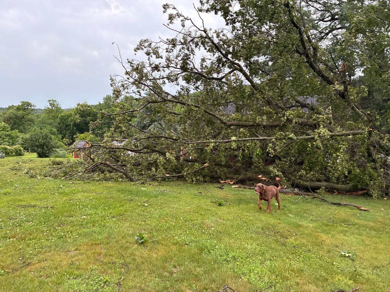 |
| Damage to a building in Bluffton, IN (Matthew Hartman) |
Tree down onto a home in Kalida, OH (Putnam County EMA) |
Powerlines damaged on US 421 near Wanatah, IN (La Porte County EMA) |
Trees down in Logansport, IN (White County EMA) |
Rain Reports
Public Information Statement
National Weather Service Northern Indiana
1103 AM EDT Fri Jun 20 2025

...48 HOUR RAINFALL REPORTS...

Location                     Amount    Time/Date       Lat/Lon

...Indiana...

...Adams County...
0.8 N Linn Grove             0.66 in   0845 AM 06/20   40.66N/85.03W

...Allen County...
Fort Wayne 6.8 NE            2.03 in   0700 AM 06/20   41.13N/85.03W
Fort Wayne 4.1 NE            1.90 in   0700 AM 06/20   41.12N/85.09W
FORT WAYNE                   1.82 in   1046 AM 06/20   41.10N/85.22W
Fort Wayne 2.6 NE            1.65 in   0700 AM 06/20   41.10N/85.11W
FORT WAYNE                   1.58 in   0957 AM 06/20   41.03N/85.17W
Fort Wayne 7.6 SE            1.53 in   0700 AM 06/20   41.01N/85.02W
Woodburn 2.6 NNW             1.51 in   0900 AM 06/20   41.16N/84.88W
Ellisville 0.3 W             1.40 in   0730 AM 06/20   41.02N/85.29W
Fort Wayne 10.1 WSW          1.39 in   0700 AM 06/20   41.03N/85.32W
Fort Wayne 9.3 W             1.36 in   0700 AM 06/20   41.05N/85.31W
Fort Wayne 8.7 W             1.34 in   0800 AM 06/20   41.08N/85.31W
Woodburn 2.8 WSW             1.22 in   0700 AM 06/20   41.12N/84.91W
Fort Wayne International Ap  1.21 in   1056 AM 06/20   40.98N/85.18W
Fort Wayne 9.1 SE            1.20 in   0700 AM 06/20   40.99N/85.00W
SPENCERVILLE                 1.17 in   1045 AM 06/20   41.25N/84.89W
Hoagland 1.5 SSW             1.10 in   0700 AM 06/20   40.93N/85.00W
FORT WAYNE                   1.07 in   1037 AM 06/20   41.02N/85.31W
4 S Tuckers Corner           0.84 in   1050 AM 06/20   40.99N/84.94W

...Blackford County...
(KA9VIS) Hartford City 0.7 N 1.20 in   0700 AM 06/20   40.46N/85.37W
Hartford City 4 ESE          1.19 in   0800 AM 06/20   40.44N/85.29W

...Cass County...
Young America                1.33 in   0800 AM 06/20   40.57N/86.33W
Galveston                    1.03 in   0945 AM 06/20   40.56N/86.19W

...De Kalb County...
Hamilton 3.0 ESE             1.71 in   0700 AM 06/20   41.52N/84.86W
Corunna 1.1 S                1.62 in   0700 AM 06/20   41.42N/85.15W
Auburn 1.1 NNE               1.44 in   0700 AM 06/20   41.38N/85.05W
0.6 S Garrett                1.20 in   0615 AM 06/20   41.34N/85.13W
Auburn Dekalb C              1.10 in   1035 AM 06/20   41.30N/85.07W
Garrett                      0.90 in   0950 AM 06/20   41.33N/85.13W

...Elkhart County...
Wakarusa 2.4 NNE             2.11 in   0700 AM 06/20   41.57N/85.99W
Goshen 3.5 NNW               1.82 in   0700 AM 06/20   41.62N/85.87W
Jamestown                    1.65 in   0928 AM 06/20   41.64N/86.04W
Elkhart 4.8 SW               1.64 in   0600 AM 06/20   41.64N/86.04W
Goshen 1.4 SSE               1.38 in   0700 AM 06/20   41.56N/85.83W
Goshen 1.8 SE                1.06 in   0700 AM 06/20   41.56N/85.81W
Syracuse 2.0 NW              1.02 in   0708 AM 06/20   41.44N/85.78W
Elkhart Municipa             0.81 in   0955 AM 06/20   41.72N/86.00W
Ligonier 4.3 WNW             0.66 in   0800 AM 06/20   41.48N/85.67W

...Fulton County...
Kewanna 4.9 S                1.59 in   0700 AM 06/20   40.95N/86.41W
Rochester 2.4 NW             1.28 in   0700 AM 06/20   41.09N/86.23W
Rochester                    1.13 in   0700 AM 06/20   41.07N/86.21W

...Grant County...
2.2 N Marion                 1.91 in   0700 AM 06/20   40.58N/85.66W
Marion 6.5 N                 1.76 in   0700 AM 06/20   40.64N/85.69W
MARION                       1.53 in   1035 AM 06/20   40.62N/85.71W
Grant County Municipal Apt   1.24 in   0955 AM 06/20   40.48N/85.68W
Marion 5.6 NE                1.13 in   0600 AM 06/20   40.60N/85.59W

...Huntington County...
Huntington                   1.56 in   1048 AM 06/20   40.83N/85.53W
Huntington 0.3 W             1.32 in   0700 AM 06/20   40.88N/85.51W
Huntington 8.6 N             1.31 in   0700 AM 06/20   41.00N/85.48W
Huntington 5.7 ENE           1.14 in   0700 AM 06/20   40.92N/85.41W
1.7 E Bowerstown             1.13 in   1000 AM 06/20   40.90N/85.41W
2.4 NW Warren                0.91 in   0845 AM 06/20   40.71N/85.45W
Huntington                   0.85 in   1035 AM 06/20   40.85N/85.45W

...Jay County...
(W9JKL) Portland 0.6 SSW     0.87 in   0700 AM 06/20   40.42N/84.99W
(KC9LQY) Portland 5.4 SW     0.42 in   0700 AM 06/20   40.39N/85.06W

...Kosciusko County...
Cromwell 2.9 W               1.94 in   0700 AM 06/20   41.40N/85.67W
2 N North Webster            1.45 in   0800 AM 06/20   41.36N/85.70W
Claypool 1.2 E               1.44 in   0715 AM 06/20   41.13N/85.86W
Warsaw 3.0 SE                1.24 in   0800 AM 06/20   41.21N/85.80W
2.3 N North Webster          1.21 in   0159 AM 06/20   41.36N/85.70W
North Webster 0.6 ESE        1.09 in   0800 AM 06/20   41.32N/85.69W
Warsaw 1.2 NNE               0.94 in   0700 AM 06/20   41.25N/85.84W
Milford 0.9 N                0.94 in   0700 AM 06/20   41.42N/85.85W
Syracuse                     0.92 in   1055 AM 06/20   41.42N/85.76W
Warsaw 1.4 N                 0.77 in   0700 AM 06/20   41.26N/85.85W

...La Porte County...
2 SW Michigan City           1.80 in   0400 PM 06/18   41.70N/86.90W
Wanatah 4.4 ESE              1.03 in   0900 AM 06/20   41.41N/86.81W
La Crosse 1.2 W              1.02 in   0800 AM 06/20   41.32N/86.91W
La Porte 6.8 SW              1.01 in   0800 AM 06/20   41.55N/86.82W
La Porte 1.6 SW              0.82 in   0800 AM 06/20   41.59N/86.73W
0.8 W La Porte               0.80 in   1258 AM 06/20   41.61N/86.73W

...Lagrange County...
Orland 6.6 SSW               1.42 in   0700 AM 06/20   41.64N/85.20W
LaGrange 1.3 ENE             1.34 in   0709 AM 06/20   41.65N/85.40W
Lagrange 9.6 ESE             1.06 in   0700 AM 06/20   41.59N/85.24W

...Marshall County...
Plymouth 2.5 WSW             1.55 in   0430 AM 06/20   41.33N/86.36W
1.2 W Plymouth               0.79 in   0945 AM 06/20   41.34N/86.34W

...Miami County...
Macy 2.7 SSE                 2.18 in   0700 AM 06/20   40.92N/86.12W
Amboy                        1.96 in   0945 AM 06/20   40.59N/85.98W
Peru                         1.89 in   0930 AM 06/20   40.75N/86.07W
Denver 0.5 SSE               1.49 in   0700 AM 06/20   40.86N/86.07W
Denver 1.3 NE                1.47 in   0700 AM 06/20   40.88N/86.06W
Grissom AFB Peru             0.93 in   0955 AM 06/20   40.63N/86.15W

...Noble County...
Ligonier                     1.63 in   1054 AM 06/20   41.46N/85.59W
Ligonier 5.3 ENE             1.51 in   0825 AM 06/20   41.49N/85.50W
Huntertown 3.2 NW            1.42 in   0700 AM 06/20   41.27N/85.21W
Kendallville 4.5 NW          1.35 in   0700 AM 06/20   41.50N/85.31W
Albion 3.7 S                 1.26 in   0930 AM 06/20   41.34N/85.42W
Cosperville                  1.08 in   1030 AM 06/20   41.48N/85.48W
Kendallville                 0.96 in   0955 AM 06/20   41.47N/85.25W

...Pulaski County...
Winamac 9.1 SW               2.22 in   0900 AM 06/20   40.96N/86.73W
Francesville                 1.81 in   0700 AM 06/20   40.98N/86.89W
Monterey 2.2 WNW             1.74 in   0800 AM 06/20   41.17N/86.52W

...St. Joseph County...
Walkerton 4.1 ENE            1.27 in   0705 AM 06/20   41.49N/86.41W
Mishawaka 2.0 E              1.20 in   0700 AM 06/20   41.66N/86.13W
South Bend 3.3 SE            1.20 in   0715 AM 06/20   41.64N/86.23W
Mishawaka 3.9 ENE            1.19 in   0710 AM 06/20   41.68N/86.10W
South Bend 4.6 SE            1.07 in   0700 AM 06/20   41.62N/86.22W
South Bend 4.0 NNE           0.71 in   0819 AM 06/20   41.72N/86.23W
South Bend International Ap  0.63 in   1054 AM 06/20   41.70N/86.32W
3 E Chain-O-Lakes            0.63 in   1057 AM 06/20   41.71N/86.32W
0.9 W Roseland               0.43 in   1015 AM 06/20   41.72N/86.27W

...Starke County...
Winona                       2.14 in   0800 AM 06/20   41.24N/86.57W
Culver 3.1 WNW               1.63 in   0700 AM 06/20   41.24N/86.48W
3.5 N Brems                  0.55 in   1000 AM 06/20   41.39N/86.71W

...Steuben County...
Angola 8.7 ESE               1.57 in   0700 AM 06/20   41.61N/84.84W
Angola                       1.51 in   0700 AM 06/20   41.64N/84.99W
Angola 8.8 ESE               1.40 in   0700 AM 06/20   41.62N/84.83W
Hudson 6.4 WNW               1.04 in   0800 AM 06/20   41.58N/85.19W
Hudson 4.1 NNW               0.92 in   0700 AM 06/20   41.59N/85.10W
Hudson 4.6 N                 0.85 in   0715 AM 06/20   41.60N/85.09W

...Wabash County...
Wabash 0.3 NNW               1.61 in   0600 AM 06/20   40.80N/85.83W
Wabash 1.5 SW                1.61 in   0700 AM 06/20   40.78N/85.84W
La Fontaine 1.1 NW           1.60 in   0800 AM 06/20   40.68N/85.74W
3.0 SE Lagro                 1.26 in   1015 AM 06/20   40.81N/85.68W
0.7 SE Wabash                0.99 in   0930 AM 06/20   40.79N/85.82W

...Wells County...
Craigville 2.7 NW            1.08 in   0800 AM 06/20   40.80N/85.13W
Bluffton 0.9 SE              0.80 in   0700 AM 06/20   40.73N/85.16W

...White County...
Monticello 5.5 NNW           1.68 in   0800 AM 06/20   40.82N/86.79W
5.6 N Badger Grove           0.90 in   0535 AM 06/20   40.67N/86.95W

...Whitley County...
Columbia City 7.4 N          1.55 in   0800 AM 06/20   41.26N/85.50W
Tri-Lakes 3.0 N              1.52 in   0700 AM 06/20   41.26N/85.49W
Columbia City 4.6 S          1.18 in   0600 AM 06/20   41.09N/85.47W
Columbia City 0.5 WSW        1.10 in   0800 AM 06/20   41.16N/85.49W

...Michigan...

...Berrien County...
St. Joseph 2.8 SSE           1.28 in   0700 AM 06/20   42.06N/86.47W
3.7 S Watervliet             0.91 in   1000 AM 06/20   42.13N/86.25W
Benton Harbor                0.86 in   1053 AM 06/20   42.13N/86.42W
Niles 2.7 W                  0.75 in   0800 AM 06/20   41.84N/86.30W
Buchanan 1.4 ESE             0.73 in   0700 AM 06/20   41.82N/86.34W
Baroda 1.3 W                 0.61 in   0700 AM 06/20   41.95N/86.51W
Niles                        0.61 in   1045 AM 06/20   41.83N/86.25W
St. Joseph 1.5 SSE           0.53 in   0700 AM 06/20   42.08N/86.48W

...Branch County...
1 SSW Coldwater              2.16 in   0933 AM 06/20   41.92N/85.01W
QUINCY                       1.88 in   0930 AM 06/20   41.94N/84.90W
Coldwater                    1.20 in   1055 AM 06/20   41.92N/85.03W

...Cass County...
Cassopolis 9.0 SSE           1.52 in   0700 AM 06/20   41.79N/85.95W
2 NNW Edwardsburg            0.81 in   0700 AM 06/20   41.84N/86.10W
Niles 3.5 E                  0.71 in   0900 AM 06/20   41.84N/86.18W

...Hillsdale County...
Jonesville 5.9 ENE           1.50 in   0615 AM 06/20   42.01N/84.56W
Hillsdale 2.5 ESE            1.28 in   0800 AM 06/20   41.91N/84.59W

...St. Joseph County...
2.0 SE Mendon                1.11 in   0900 AM 06/20   41.98N/85.43W

...Ohio...

...Allen County...
Elida 1.4 WNW                1.74 in   0703 AM 06/20   40.80N/84.22W
Bluffton                     1.17 in   1045 AM 06/20   40.89N/83.89W
Ada 3.0 W                    0.94 in   0700 AM 06/20   40.77N/83.88W
Delphos 2.3 ESE              0.82 in   0600 AM 06/20   40.83N/84.30W
Lima 2.7 NE                  0.77 in   0700 AM 06/20   40.77N/84.08W
2 WNW Westminster            0.74 in   0953 AM 06/20   40.71N/84.02W
Lima 1 N                     0.71 in   0927 AM 06/20   40.78N/84.12W
Lima 7.3 SE                  0.55 in   0700 AM 06/20   40.66N/84.03W

...Defiance County...
Defiance                     0.63 in   0853 AM 06/20   41.33N/84.43W

...Fulton County...
Swanton 4.0 S                1.38 in   0654 AM 06/20   41.53N/83.91W
Archbold 4.7 NW              0.88 in   0530 AM 06/20   41.57N/84.36W

...Henry County...
Napoleon 1.2 SSE             1.46 in   0700 AM 06/20   41.38N/84.12W
Liberty Center 0.3 NE        1.15 in   0700 AM 06/20   41.45N/84.00W
Napoleon 1 SW                1.10 in   0730 AM 06/20   41.38N/84.15W
Napoleon 0.6 WSW             1.03 in   0800 AM 06/20   41.39N/84.14W
Napoleon 4.5 NNW             1.02 in   0700 AM 06/20   41.46N/84.15W
New Bavaria 2.3 WSW          0.92 in   0700 AM 06/20   41.19N/84.21W

...Paulding County...
Paulding 5.6 ESE             1.11 in   0700 AM 06/20   41.09N/84.49W

...Putnam County...
Ottawa 1.2 ENE               1.22 in   0956 AM 06/20   41.03N/84.02W
Ottawa 1.0 N                 1.16 in   0700 AM 06/20   41.04N/84.04W

...Van Wert County...
1 WNW Convoy                 0.76 in   1050 AM 06/20   40.93N/84.74W
Van Wert                     0.70 in   0927 AM 06/20   40.87N/84.59W
Van Wert                     0.65 in   0930 AM 06/20   40.85N/84.48W

...Williams County...
3 S Nettle Lake              2.08 in   0950 AM 06/20   41.63N/84.73W
1.2 E Bryan                  0.92 in   0700 AM 06/20   41.46N/84.53W
Bryan 2.1 NNW                0.80 in   0641 AM 06/20   41.50N/84.56W

Observations are collected from a variety of sources with varying
equipment and exposures. We thank all volunteer weather observers
for their dedication. Not all data listed are considered official.
Radar
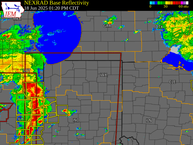 |
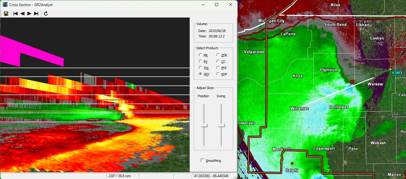 |
| Radar loop of the squall line courtesy of IEM | Radar cross section (left) through the squall line showing the rear inflow jet as it moved from west to east. Cross section is showing storm relative velocity and right image is a plan view image of base velocity. |
Environment
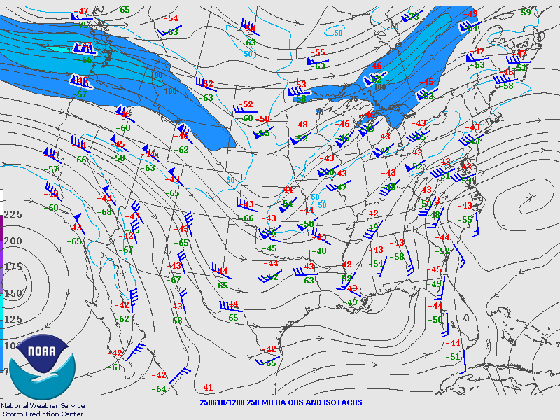
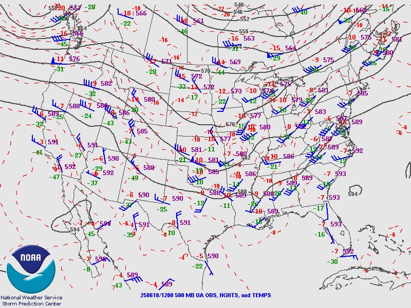
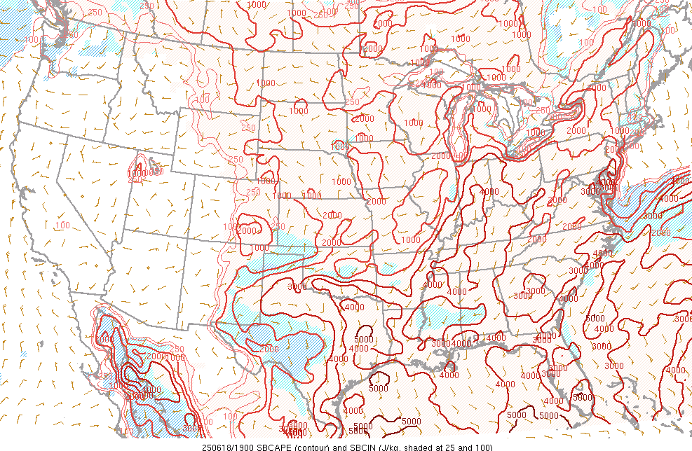
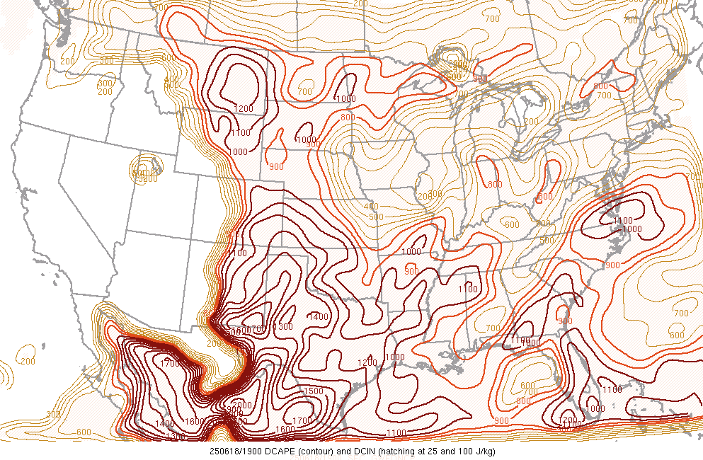
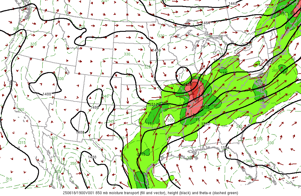
A surface cold front and attendant 500-mb trough moved through on the afternoon and evening of June 18th. Despite scattered non-severe storms after daybreak, the atmosphere recovered instability ahead of the cold front in the afternoon. By 3 PM ET, surface based CAPE was 2000-4000 J/kg from south to north across the area. The best shear of 40-50 kts lagged behind the main line of storms closer to the cold front. Dewpoints were in the upper 60s to mid 70s due to low level and mid level southwesterly winds bringing in moisture from the Gulf.
 |
 |
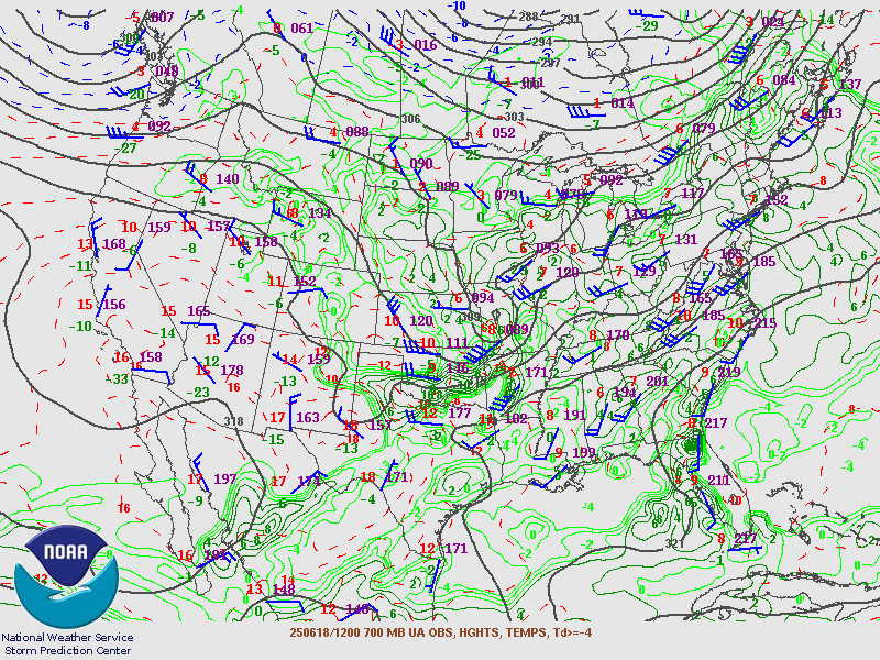 |
| Figure 1: 12Z June 18th 250mb chart | Figure 2: 12Z June 18th 500mb chart | Figure 3: 12Z June 18th 700mb chart |
 |
 |
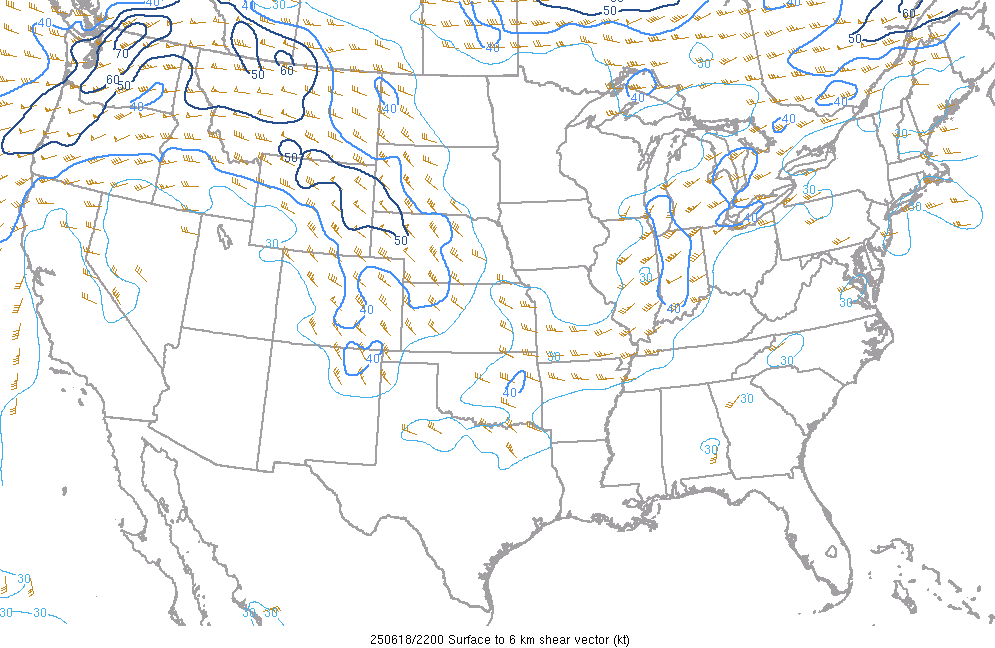 |
| Figure 4: 19Z June 18th Surface Based CAPE | Figure 5: 19Z June 18th Downdraft CAPE | Figure 6: 22Z June 18th 0-6 km Shear |
 |
 |
 |
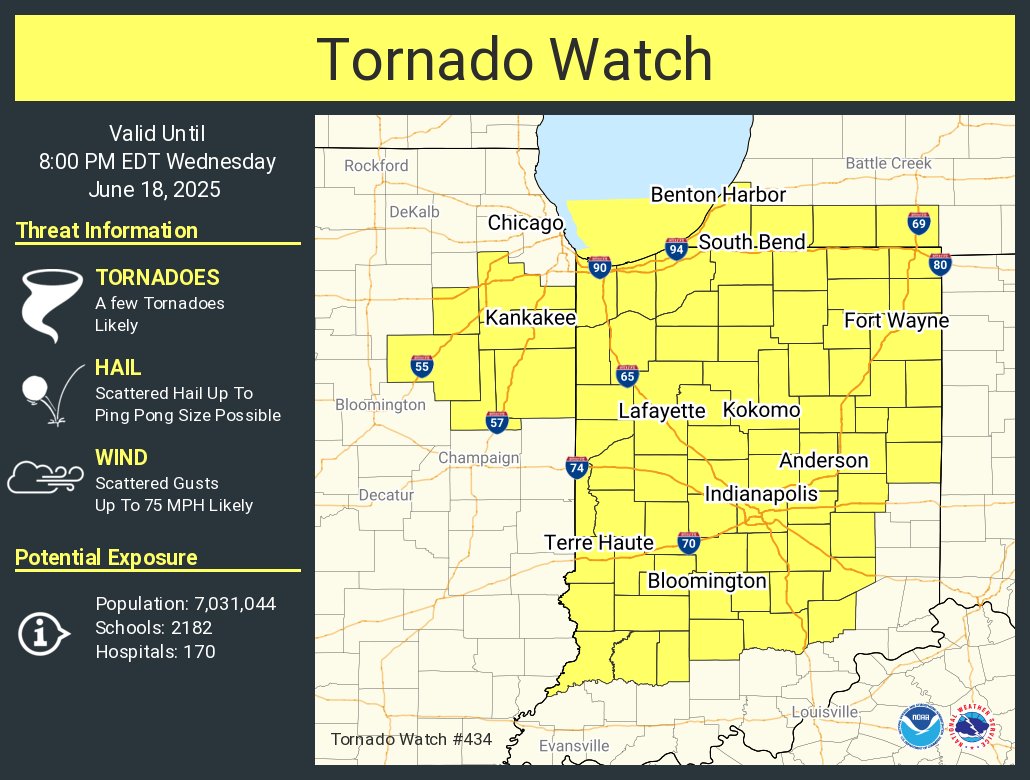
| Figure 7: 19Z June 18th Moisture Transport | Figure 8: Tornado Watch for northern Indiana and southwest Lower Michigan | Figure 9: Severe Thunderstorm Watch for northwest Ohio and southeast Lower Michigan |
 |
 |
 |
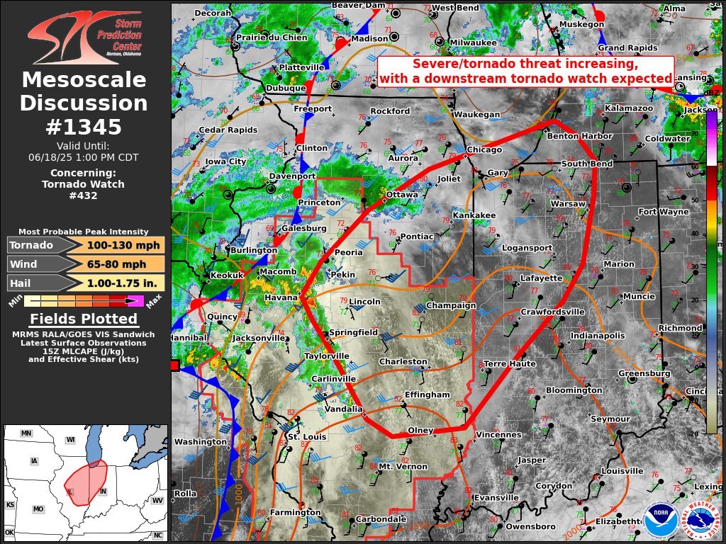
| Figure 9: SPC MD #1345 | Figure 10: SPC MD #1346 | Figure 11: SPC MD #1349 |
 |
Media use of NWS Web News Stories is encouraged! Please acknowledge the NWS as the source of any news information accessed from this site. |
|


.jpg)