October 24th, 2001 Tornado Outbreak
Story Compiled by NWS Northern Indiana Staff
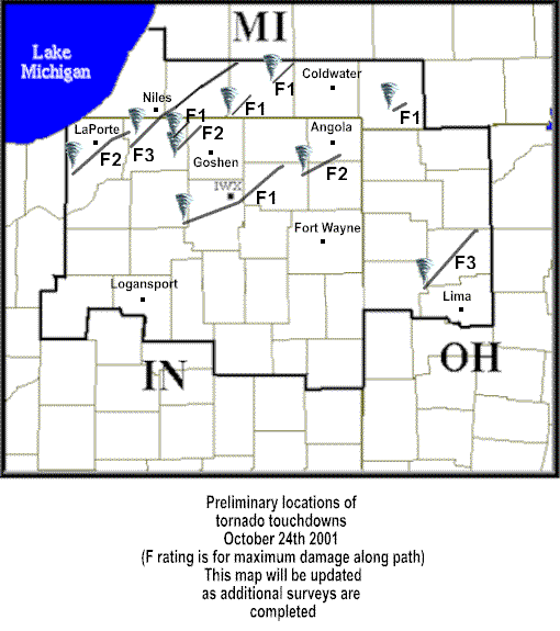
Tornadoes can develop under the right circumstances any time of the day, any time of the year in northern Indiana, northwest Ohio and southern Michigan. On the afternoon of October 24, 2001 conditions were highly favorable for a significant outbreak of severe weather throughout the lower Great Lakes region. A warm, unstable air mass was in place, with southerly winds pumping in a supply of moist air (65 to 70 degree dew points). Storms began to quickly develop during the afternoon as a strong cold front approached from the west. This cold front exhibited a striking contrast of air masses with temperatures plummeting about 15 degrees within an hour of the front?s passage. This front provided the focus for rapid thunderstorm development. Also, the wind field was conducive for developing strong rotation in the storms that led to tornado development in the strongest storms. The winds at the surface were generally from the southeast to south up to 20 mph. Meanwhile winds just a few thousand feet above the ground were from the southwest at speeds of 50 to 70 mph. This shift in wind direction and increase in wind speed greatly enhanced the threat for tornadic storms. See the map below for tornado tracks and F scale ratings of the October 24th storms. You can also read the damage survey conducted by the NWS Northern Indiana Office. A complete timeline of events from October 24th is also available.
PUBLIC INFORMATION STATEMENT
NATIONAL WEATHER SERVICE NORTHERN INDIANA
600 AM EST FRI NOV 2 2001


...SUMMARY OF PRELIMINARY TORNADO TRACKS FROM OCTOBER 24, 2001


1) ST. JOSEPH COUNTY INDIANA AND
     BERRIEN...CASS...AND ST. JOSEPH COUNTY MICHIGAN...

     F3 TORNADO...TOUCHDOWN 1 MILE SOUTHWEST OF CRUMSTOWN INDIANA...
     MOVED NORTHEAST ACROSS NORTHWEST SOUTH BEND INDIANA TO
     JUST SOUTH OF NILES MI THROUGH THE  SOUTHEAST CORNER OF BERRIEN
     COUNTY...AND INTO CASS COUNTY MICHIGAN. THE TORNADO MOVED
     THROUGH EDWARDSBURG NORTHEAST THROUGH CASSOPOLIS...ON INTO
     HOWARDSVILLE IN THE NORTHWEST CORNER OF ST. JOSEPH COUNTY
     MICHIGAN.

     MAXIMUM DAMAGE WAS IN CRUMSTOWN INDIANA...MOST DAMAGE F1

     PATH LENGTH...47 MILES...PATH WAS INTERMITTENT FOR MUCH OF LATTER
     HALF

     MAXIMUM WIDTH...3/4 MILE

     NO KNOWN DEATHS OR INJURIES


2) ST. JOSEPH MICHIGAN...

    F1 TORNADO...TOUCHDOWN NEAR THE ELKHART/ST. JOSEPH
    MICHIGAN COUNTY BORDER SOUTHWEST OF WHITE PIGEON. SKIPPED
    NORTHEAST...LIFTED ONE MILE NORTH OF WHITE PIGEON.

    MAXIMUM DAMAGE AT THE INTERSECTION OF ROUTES 131 AND 12...WHERE
    HIGH TENSION WIRES...TREES...AND BUILDINGS WERE DAMAGED.

    PATH LENGTH...SKIPPING OVER 4 MILES

    MAXIMUM WIDTH...400 YARDS

    ONE INJURY...VEHICLE WAS LIFTED AND TURNED


3) ST. JOSEPH MICHIGAN...

    F1 TORNADO...TOUCHDOWN TWO MILES WEST OF COLON...SKIPPED
    NORTHEAST...LIFTED TWO MILES EAST OF LEONIDAS.

    MAXIMUM DAMAGE WAS A BARN DESTROYED...DEBRIS THROWN ABOUT A HALF
    MILE

    PATH LENGTH...SKIPPING OVER 5 MILES

    MAXIMUM WIDTH...400 YARDS

    NO KNOWN DEATHS OR INJURIES


4) EAST ST. JOSEPH COUNTY INTO EXTREME NORTHWEST ELKHART COUNTY...

    F1 TORNADO...TOUCHDOWN NEAR INTERSECTION OF DOUGLAS ROAD
    AND BITTERSWEET ROAD. SKIPPED NORTHEAST AND LIFTED
    TWO HUNDRED FEET EAST OF THE ASH ROAD OVERPASS OVER THE
    TOLL ROAD.

    MAXIMUM DAMAGE ON BUCKEYE ROAD AND AT THE ASH ROAD
    OVERPASS OVER THE TOLL ROAD...DAMAGE WAS INTERMITTENT ALONG THE
    ENTIRE PATH

    PATH LENGTH...SKIPPING OVER A 2 AND A HALF MILE DISTANCE

    MAXIMUM WIDTH...50 YARDS

    NO KNOWN DEATHS OR INJURIES


5) EAST ST. JOSEPH COUNTY INDIANA INTO NORTHWEST ELKHART COUNTY...

    F2 TORNADO...PREVIOUSLY THIS TORNADO WAS THOUGHT TO HAVE BEEN AN
    F0 AND TO ONLY HAVE HIT THE COBUS GREEN MOBILE HOME COMMUNITY ON
    WEST COUNTY LINE ROAD WEST OF ELKHART. FURTHER INVESTIGATION
    REVEALED THAT THIS TORNADO ACTUALLY FIRST TOUCHED DOWN ON
    BLACKBERRY ROAD HALF A MILE SOUTH OF HARRISON ROAD...SOUTHEAST
    OF MISHAWAKA. THE TORNADO TRAVELED NORTHEAST THROUGH THE WEST
    SIDE OF OSCEOLA TO CHAPEL HILL MEMORIAL GARDENS CEMETERY...THEN
    SKIPPED NORTHEAST TO COBUS GREEN AND LIFTED JUST NORTH OF THE
    ELKHART AIRPORT. DAMAGE ALONG THE TRACK NORTHEAST OF THE
    CEMETERY WAS INTERMITTENT.

    MAXIMUM DAMAGE ON SOUTH SHORE AVENUE BETWEEN MISHAWAKA AND
    OSCEOLA...MOST DAMAGE ALONG THE REST OF THE PATH WAS F0

    PATH LENGTH...ON THE GROUND FOR TWO AND A HALF MILES...THEN
    SKIPPING FOR AN ADDITIONAL 5 MILES

    MAXIMUM WIDTH...3/4 MILE

    NO KNOWN DEATHS OR INJURIES


6) VAN WERT AND PUTNAM COUNTIES...

    F3 TORNADO...TOUCHDOWN JUST NORTHWEST OF DELPHOS IN VAN WERT
    COUNTY MOVING NORTHEAST ACROSS PUTNAM COUNTY...LIFTING JUST
    SOUTH OF THE PUTNAM AND HENRY COUNTY LINE. THE TORNADO DID
    NOT MOVE INTO HENRY COUNTY

    MAXIMUM DAMAGE 2 MILES SOUTHWEST OF OTTAWA...MOST DAMAGE F1 OR F2

    PATH LENGTH...SKIPPING OVER A 32 MILE DISTANCE

    MAXIMUM WIDTH...UP TO THREE QUARTERS OF A MILE

    NO KNOWN DEATHS OR INJURIES


7) LAPORTE AND ST. JOSEPH COUNTIES IN...

    F2 TORNADO...TOUCHDOWN JUST NORTH OF WANATAH MOVING EAST OF
    LAPORTE TO NORTHEAST...THEN LIFTED 5 MILES WEST OF SOUTH
    BEND...NEAR WESTFIELD.

    MAXIMUM DAMAGE 4 MILES EAST OF LAPORTE...MOST DAMAGE F0 TO F1

    PATH LENGTH...SKIPPING OVER A 35 MILE DISTANCE

    MAXIMUM WIDTH...UP TO 1 MILE

    1 DEATH...4 MILES EAST OF LAPORTE

    NO KNOWN INJURIES


8) MARSHALL...KOSCIUSKO...AND NOBLE COUNTIES IN

    F1 TORNADO...TOUCHDOWN 2 MILES SOUTHEAST OF TIPPECANOE THROUGH
    NORTHERN WARSAW THROUGH NORTH WEBSTER LIFTING NEAR ROME CITY.

    MAXIMUM DAMAGE WAS IN NORTHERN WARSAW...MOST DAMAGE F0

    PATH LENGTH...39 MILES

    MAXIMUM WIDTH...150 YARDS

    14 KNOWN INJURIES

    NO KNOWN DEATHS


9) NOBLE...DEKALB...AND STEUBEN COUNTIES IN...

    F2 TORNADO...TOUCHDOWN 1 MILE EAST OF KENDALLVILLE...PASSING
    THROUGH FAIRFIELD CENTER AND THE SOUTHEAST SIDE OF ASHLEY AND
    LIFTED ABOUT 1 MILE NORTH OF STEUBENVILLE.

    MAXIMUM DAMAGE WAS NEAR FAIRFIELD CENTER...MOST DAMAGE F0 TO F1

    PATH LENGTH...12 1/2 MILES

    MAXIMUM WIDTH...1/4 MILE

    NO KNOWN DEATHS OR INJURIES


10) HILLSDALE COUNTY MI

    F1 TORNADO...TOUCHDOWN 1 MILE SOUTHWEST OF RANSOM AND LIFTED 1
    MILE NORTH OF RANSOM

    MAXIMUM DAMAGE ON THE NORTH SIDE OF RANSOM...MOST DAMAGE F0

    PATH LENGTH...2 MILES

    MAXIMUM WIDTH...60 YARDS

    NO KNOWN DEATHS OR INJURIES


NOTE...THIS DATA IS PRELIMINARY AND MAY BE CHANGED AS NEW
INFORMATION BECOMES AVAILABLE.
Amateur photographer Ed Sloan captured the Kosciusko County tornado on film as it moved just south of North Webster near Armstrong Road. We have also put together a page with over 100 photographs from this event, many from our storm damage surveys. Feel free to email us your pictures as well.
While the tornado outbreak of October 24, 2001 was certainly a rare event, strong tornados in October have happened before. On October 24, 1967, F2 tornados struck Kosciusko and Elkhart Counties Indiana.
On October 16, 1988 an F2 tornado struck Elkhart County Indiana. The tornado damaged 21 homes and several barns on its 6 mile track as it moved across the southern part of the county.
On October 8, 1992 an F2 tornado tracked 2 miles from just south of Fort Wayne International Airport's tower in Allen County Indiana, and moved to the northeast. Windows were blown out of the control tower and five businesses were damaged. Nine people were injured.
We have compiled a complete historical summary of October tornadoes in this region. We also have individual county maps with all known tornado tracks since 1834!!
The recent tornado outbreak underscores the importance of having a plan of action in place whenever a tornado or severe thunderstorm threatens. Whether at home, work, school, or business, know where to go and what to do to protect yourself and your family. Do you have a NOAA Weather Radio to alert you to severe weather? Tornados will strike again, are you prepared? Here are some safety tips for you and your family.
Tornado Tracks on October 24th, 2001

