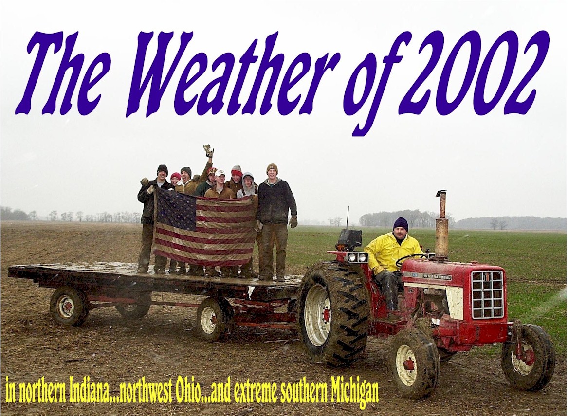
An American flag is recovered during clean-up after an F4 tornado tore through Van Wert on November 10. Photo courtesy Jan Dunlap.
Top Ten Weather Events in 2002*
1. Tornado outbreak, November 10
2. Snow and ice, January 30 - 31
3. Tornado outbreak, September 20
4. Wind, March 9
5. Flash flood, June 26
6. Record heat in April followed by frost in May
7. Snow and cold, March 25 - 27
8. Snow, February 25 - 27
9. Snow, December 24-25
10. Lightning and heavy rain, May 12
Map of the biggest events of the year
Highlights:
January 9 -- Record warm minimum temperature of 36E at South Bend.
January 11 -- Record warm minimum temperature of 32E at South Bend.
January 27 -- Record high of 59E at South Bend.
January 28 -- Record high of 58E and record warm minimum of 37E at South Bend.
January 29 -- Record warm minimum of 41E and record daily precipitation, 0.93", at Fort Wayne.
January 30 -- Record daily precipitation, 0.84", at South Bend.
January 30 - 31 -- On the 30th heavy snow fell on northwest Indiana and southwest Michigan, including 11" at Cassopolis. On the 31st the precipitation fell in the form of freezing rain over the central and northern portions of the area. Weather observers reported between one quarter and one half inch of ice accumulation on most objects. The addition of this ice on top of the heavy wet snow was too much weight for many tree limbs and power lines. Reports from power companies indicated well over 100,000 people were without power on the 31st. Hundreds of trees and tree limbs were reported down, many of them on power lines. Roads were ice covered and treacherous, and several communities issued states of emergencies. In the south, heavy rains fell that led to flooding.
January 31 -- Record daily precipitation, 0.94", at South Bend.
JANUARY -- 4th warmest and 6th least snowy at Fort Wayne. 3rd warmest at South Bend.
WINTER -- The winter of 2001-02 was the 2nd warmest winter on record at South Bend and Fort Wayne. 8th least snowy on record at Fort Wayne.
February 25 - 27 -- Winter storm dropped 1 to 5 inches of snow on the southeast half of the area, 6+ inches in the northwest, with a maximum of 16.7" at South Bend, thanks to lake enhancement. The heaviest purely synoptic snow fell at the weather office, which reported 12".
FEBRUARY -- 8th warmest at South Bend and 10th warmest at Fort Wayne.
March 2 -- 8" of snowfall occurred at Dowagiac (Cass County MI). Record daily precipitation, 0.73", at South Bend.
March 3-4 -- 6 to 12 inches of lake effect snow fell on LaPorte, St Joseph IN, Berrien, and Cass MI counties.
March 4 -- Record low of -3E and record cold maximum temperature of 17E at South Bend. Record cold maximum temperature of 20E at Fort Wayne.
March 9 -- Very strong large scale non-thunderstorm winds in excess of 50mph caused widespread damage. Elida, OH (Allen County) reported winds of 73mph. Part of the Peru Fire Department's roof was blown off. Street lights were blown over in Marion. A trailer lost its roof 4 miles WSW of Montpelier (Blackford County). A barn lost its roof 3 miles west of Roll (Blackford County). Roof removed from maintenance building near Fort Wayne International Airport. Two-story home in Fort Wayne had its roof blown off. Barn lost its roof near Fort Wayne. A barn was leveled in Wetsel, OH (Van Wert County). House lost its roof in Oakwood, OH (Paulding County). Roof blown off a trailer in Ottawa OH. Semi truck blown onto its side in Beaverdam OH (Allen County). Barn blown down in Spencerville OH (Allen County). TV tower blown down in Assumption OH (Fulton County). Roof blown off supermarket in Van Wert, trapping people inside and destroying vehicles.
March 25-27 -- Deep snows and cold temperatures spread across the area. Snowfall totals from the 25th-26th included 8" at Rochester and 10" at Paulding and Grover Hill OH (Paulding County). Low temperatures on the 27th included 8E at Montpelier OH (Williams Co), 5E at Columbia City, and 3E at Bryan OH.
April 12-- 3/4" diameter hail fell on Fort Wayne.
April 15 -- Record high of 85E and record warm minimum of 61E at Fort Wayne. Record high of 87E at South Bend.
April 16 -- Record high of 85E at Fort Wayne. Record warm minimum of 66E at South Bend.
April 17 -- 3/4" diameter hail at Glandorf OH (Putnam County). Record high of 85E and record warm minimum of 66E at Fort Wayne. Record warm minimum of 65E at South Bend.
April 18 -- Record high of 87E and record warm minimum of 62E at Fort Wayne. Record high of 86E and record warm minimum of 64E at South Bend.
April 19 -- 1" diameter hail fell on Walton in Cass County IN.
May 11 -- Thunderstorm winds blew trees down in Rochester.
May 12 -- Lightning struck a dairy barn in Wakarusa (Elkhart County) causing a fire that destroyed it and killed 7 horses and 13 cows. Flash flooding in Wauseon resulted in three homes being evacuated and one person was rescued from their vehicle. Three inches of rain fell at Millersburg (Elkhart County) and 3.37" fell at Goshen. Record daily precipitation, 1.45", at South Bend.
May 18 -- Record low of 33E at South Bend.
May 19 -- Record low of 30E at Fort Wayne and record low of 32E at South Bend.
May 21 -- Record low of 30E at South Bend.
May 25 -- 1.75" diameter hail fell at Napoleon. Storm winds destroyed two barns and a silo 3 miles west of Somerset in Wabash County.
May 28 -- Nickel-sized hail fell on New Haven (Allen County IN).
MAY -- 6th coolest and 7th wettest at South Bend. 8th wettest at Fort Wayne.
June 3 -- Trees and power lines were blown down nine miles east of Benton Harbor (Berrien County). Nickel sized hail fell at Huntertown (Allen County IN).
June 4 -- 1.75" diameter hail fell in the counties of Fulton IN, Wabash, Huntington, and Van Wert. Trees were blown down in Galveston in Miami County.
June 14 -- Dime size hail fell on Frontier MI (Hillsdale County).
June 21 -- Power lines were struck down by lightning in Waldron MI (Hillsdale County).
June 25 -- Siding blown off a home, garage damaged, trees and power lines blown down at Middle Point OH (Van Wert County).
June 26 -- Phenomenal flash flooding occurred in the city of Fort Wayne and areas of western Allen County as thunderstorms continually redeveloped over central and western parts of the metropolitan area, dropping up to 8 inches of rain (Times Corner) over the course of several hours in the evening. 3.50" of rain fell in 90 minutes at the intersection of Taylor and Broadway. Numerous cars were stranded in water up to 3 feet deep. Numerous basements were flooded, and most downtown buildings were closed the following day. Spy Run Creek hit 12.3', it's highest stage ever recorded (old record was 10.7'). Spy Run Creek rose 9 feet in 8 hours.
JUNE -- 4th driest at South Bend.
July 22 -- A barn was blown down 4 miles west of Reading (Hillsdale County) and roofs were damaged by winds in Onward (Cass County IN).
July 26 -- Trees were blown down 3 miles south of South Bend and power lines were blown down 7 miles east-southeast of Hartford City.
July 27 -- Trees were blown down from Bronson to Coldwater (Branch County).
July 29 -- A tree was blown down onto a family in their driveway, injuring three people, in Pandora (Putnam County). Record daily precipitation, 1.44", at Fort Wayne.
JULY -- 4th warmest at South Bend.
August 2 -- One inch diameter hail covered the ground 2 miles west of Elkhart (Elkhart County). Trees and power lines were blown down in the counties of Cass MI, St Joseph MI, St Joseph IN, Elkhart, and Lagrange.
August 4 -- Trees and power lines were blown down at several locations in Hillsdale County.
August 13 -- Trees and power lines were blown down in the Michigan counties of Berrien, Cass, St Joseph, and Branch, as well as in South Bend IN.
August 24 -- An 80 acre cornfield was flattened and several large oak trees snapped at the base in Elgin OH (Van Wert County).
SUMMER -- 4th driest and 5th warmest summer on record at South Bend.
September 18 -- Shed blown over and part of tin roof blown off 5 miles east of Decatur.
September 19 -- Trees and power lines were blown down in the counties of Miami, Kosciusko, Lagrange, DeKalb, St Joseph MI, Noble, Branch, and Van Wert.
September 20 -- An F1 tornado occurred from Hartford City to 3 miles northeast of Hartford City, blowing trees and power lines down and flattening buildings at a fertilizer plant. An F0 tornado then briefly traveled from 1 mile north to 2 miles north-northeast of Van Wert, causing roof damage to three houses, and also damage to a barn and numerous trees. An F1 twister then struck 5 miles east of Delphos (Allen County OH) and destroyed a barn, and brought down trees and power lines.
SEPTEMBER -- 3rd warmest and 7th driest at South Bend.
October 1 -- Record high of 85E at South Bend.
October 14 -- Record low of 32E at South Bend.
OCTOBER -- 9th coolest at South Bend and 10th coolest at Fort Wayne.
November 10 -- An F1 tornado touched down two miles southwest of Hartford City and headed northeast, through the north side of town, to three miles northeast of Hartford City. A wall was knocked out of a grocery store and other scattered structural damage was done. Then, an F0 tornado touched down for a moment near Petroleum (Wells County). This was followed by an F3 twister that touched down two miles northeast of Berne and lifted at the state line near Salem (Adams County). An F4 tornado then developed near Willshire OH (Van Wert County) and created a 53-mile path of destruction to near Malinta (Henry County). F4 damage occurred on Lincoln Highway west of Van Wert. F4 damage also occurred at the intersection of Dull-Robinson and Zook roads. There was one fatality at this location, as well as an injury. Another casualty occurred when the tornado swept a car off the road near Van Wert's Twin Cinemas, killing the driver inside. After leaving the city of Van Wert, the tornado was between F3 and F4 strength through the remainder of Van Wert County. The tornado maintained F3 strength through Paulding County and extreme northwest Putnam County. Two more fatalities took place near Continental, Ohio (Putnam County), when the tornado destroyed a mobile home. The twister then began to weaken, becoming F0 in strength across Henry County. In addition to the tornadoes, 80mph winds derailed a train 2 miles southeast of Hamler in Henry County. Also, there was record precipitation, 1.18", at Fort Wayne.
November 22 -- 5.5" of snow piled up at Lima.
November 30 -- 4 to 6 inches of snow fell on St Joseph County Indiana, Cass County Michigan, and St Joseph County Michigan.
AUTUMN -- 4th driest at South Bend.
December 4 -- Record low of 4E at South Bend.
December 18 -- Record daily precipitation, 0.82", at South Bend.
December 24-25 -- Snowfalls of 6 to 10 inches were common throughout the area, including Fort Wayne's 10th heaviest 24-hour snowfall on record, 8.2 inches.
*In the area of responsibility of the Northern Indiana National Weather Service office

