
Map of the year's most significant events
After a fairly quiet late winter and early spring, the weather across northern Indiana, extreme southern Michigan, and northwest Ohio turned explosive for much of the middle part of the year. Ten tornadoes...more than in the average year...developed between May 9 and August 26. Severe weather occurred every day from July 4 through 11, including four tornadoes. In addition to the severe weather in July, torrential rains flooded many areas, especially along and south of US 30, including Fort Wayne. July 2003 was the third wettest July on record at Fort Wayne and went towards making the summer Fort Wayne's third wettest ever seen since official records began in 1911. The weather then turned quiet again for the autumn, with South Bend experiencing its 2nd least snowy fall on record (records began in 1940), and Fort Wayne having its 8th least snowy fall season.
January 23-24
Nearly 9 inches of lake effect snow fell on Rolling Prairie, IN. Bridgman, MI received 7.
January 26
Six to seven inches of lake effect snow fell at Berrien Springs and Buchanan, MI, and Simonton Lake, IN.
January 2003 was the 9th driest January on record at South Bend. January 2003 was the 6th snowiest January on record at Fort Wayne.
February 7
A heavy band of lake effect snow moved over Berrien County from late morning to early afternoon with accumulations of up to a foot around Benton Harbor. A multi-vehicle accident occurred around 1:30pm on Interstate 94 just northeast of Benton Harbor. Approximately 60 vehicles were involved with one fatality and over two dozen injuries. More information
February 14-15
Up to half a foot of snow fell over southern sections of the area, with just flurries across the north. Snowfall map
February 17
Up to seven inches of snow fell on Putnam and Allen counties in Ohio. Snowfall map
February 22-23
Rain and freezing rain changed to heavy snow in the afternoon, tapering off that night. Ten to eleven inches of snow were reported at Marion and Hartford City. Nine to ten inches fell on Van Wert and Putnam counties. Snowfall map
February 25
Record low at Fort Wayne, -5 degrees.
February 2003 was the 7th driest February on record at South Bend. February 2003 was the 5th snowiest February on record at Fort Wayne. Winter 2002-2003 was the 5th driest winter on record at South Bend.
March 4-5
Up to half a foot of snow fell in a band only a few miles wide from Michigan City, IN to Berrien Center, MI. Snowfall map
March 9
Record cold maximum temperature at South Bend, 21 degrees.
March 10
Record cold maximum temperature at South Bend, 22 degrees.
March 13
Hail piled up at the weather office during a thunderstorm that occurred with a temperature of 34 degrees.
March 15
WFO Northern Indiana participated in Advanced SKYWARN Training in Elkhart, IN, sponsored by IMO SKYWARN.
March 17
South Bend records its warmest Saint Patrick's Day temperature of 72 degrees. Fort Wayne does the same with 71 degrees.
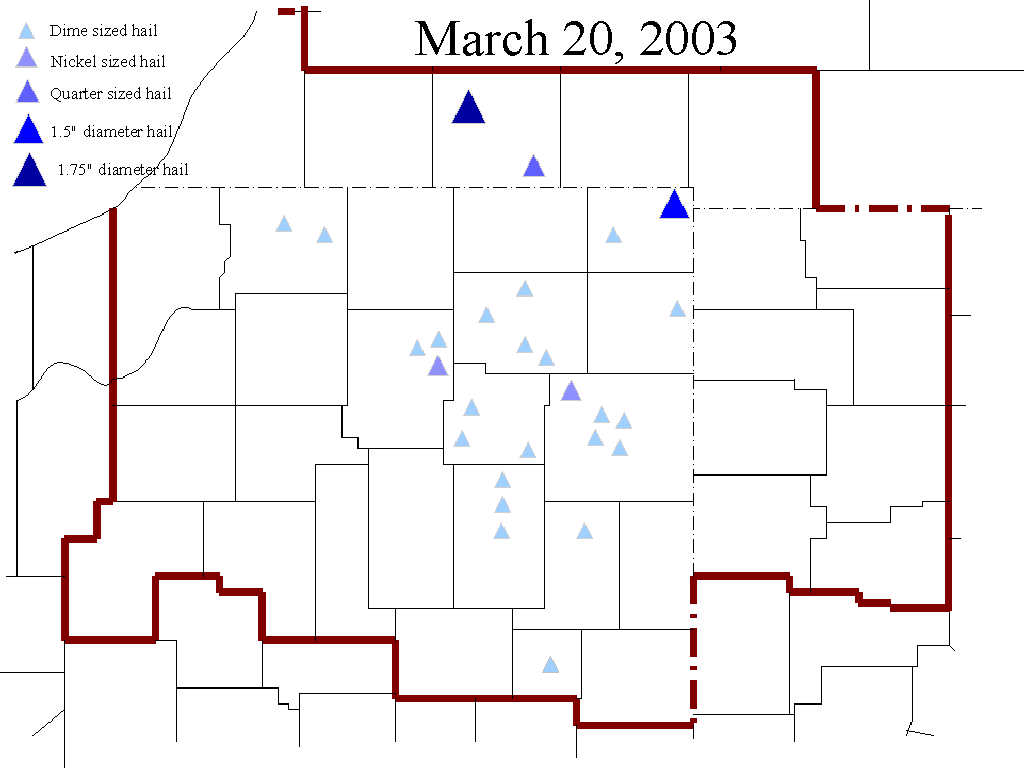
March 20
The first severe weather outbreak of the season, including golf ball sized hail in Three Rivers, Michigan. Hail map
March 24
Record high of 75 degrees at South Bend.
March 28
Thunderstorm winds of at least 50 mph blew through DeKalb and Steuben counties. Fort Wayne sets a new daily precipitation record of 1.42".
March 2003 was the 7th driest March on record at South Bend.
April 4
Widespread severe weather, including golf ball sized hail in Noble County and 70mph winds five miles northwest of Columbia City, IN. South Bend set a daily precipitation record with 1.89" of rainfall, and Fort Wayne did the same with 1.60". Severe weather map
April 7
Record cool daily maximum at Fort Wayne, 36 degrees.
April 14
Record high at South Bend, 81 degrees.
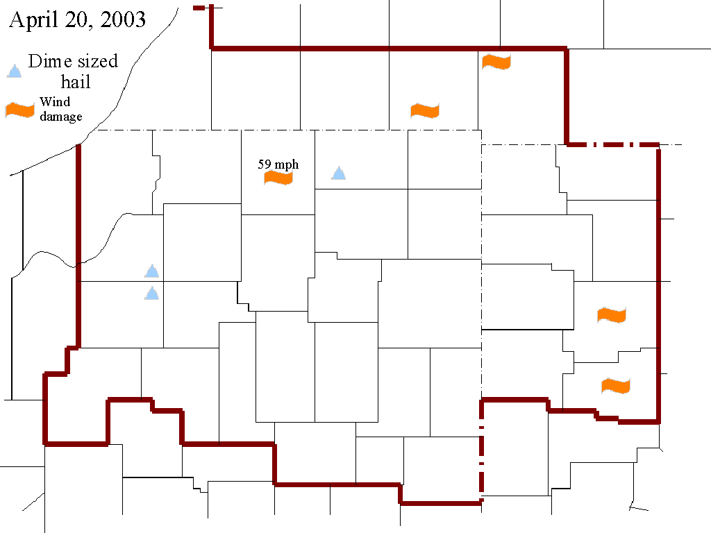
April 20-21
Another widespread severe weather event, with 60mph winds in Allen and Putnam counties in northwest Ohio. Roof damage occurred at Lima High School. Severe weather map
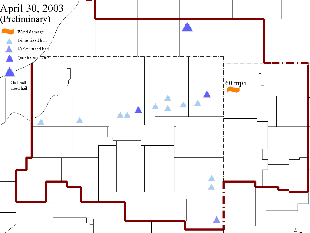
April 30
Severe storms brought golf ball sized hail to Union City, Michigan and 60mph winds to Kosciusko County. Severe weather map
May 1
Flood stage on the Eel River at North Manchester changed to 9 feet.
May 5
Record daily precipitation at South Bend, 0.86", and record daily precipitation at Fort Wayne with 1.82".
May 7
One of only two severe weather outbreaks of the month took place. Golf ball sized hail pounded Berrien and Cass counties in Michigan and Elkhart County, Indiana. Damage to the tune of $8,000 occurred at Klug's nursery in Berrien Springs, Michigan, when hail fell for nearly 20 minutes. Hail fell for 15 minutes west of Cassopolis and accumulated to a depth of one foot.
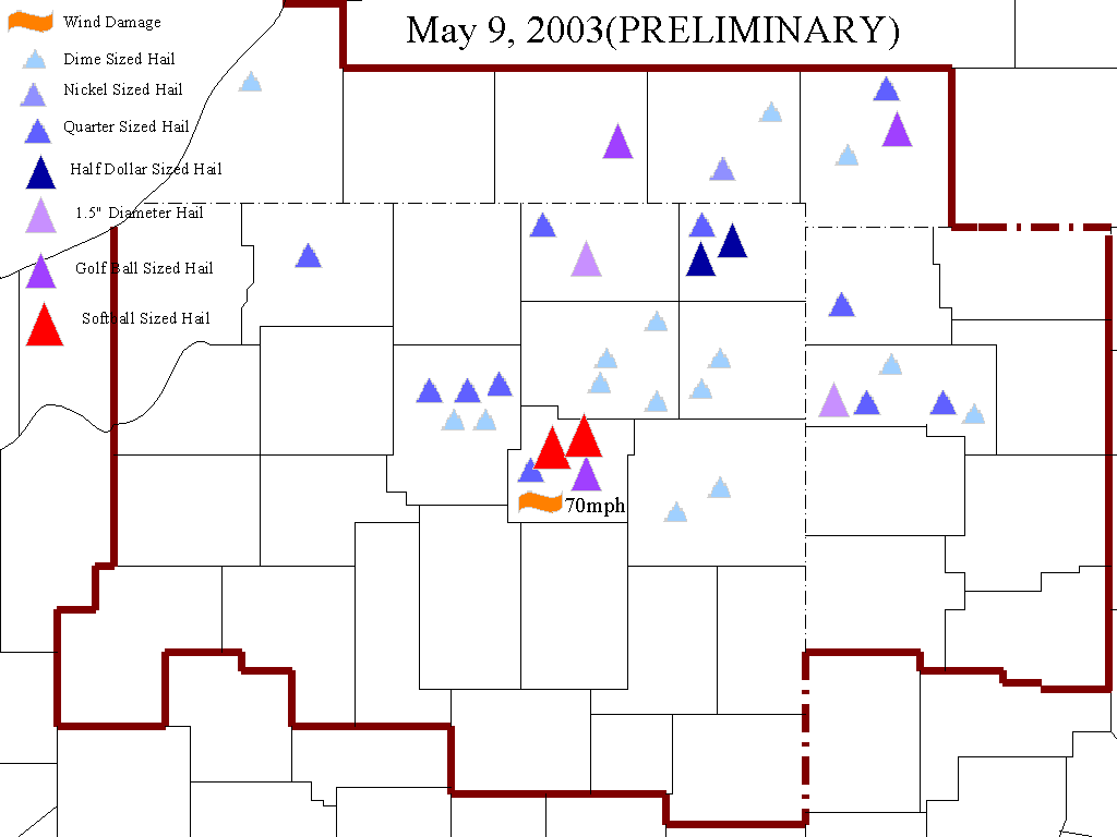
May 9
Record daily precipitation at Fort Wayne, 1.51".
May 9-10
The year's first tornado struck, doing F1 damage six miles south of Pierceton, Indiana. A mini-van was traveling southbound, was picked up by the tornado and tossed 15 feet to the west into a field. A downburst associated with the tornado created extensive damage in the area, mainly to trees, roofs, and vehicles. Also, the year's largest hailstones fell, when hail larger than grapefruit was witnessed five miles west of Columbia City and two miles north of Columbia City, Indiana. Severe weather map
May 2003 was the 5th wettest May on record at South Bend and Fort Wayne.
June 1
Record low at South Bend, 36 degrees.
June 8
58mph thunderstorm winds blew down trees and power lines six miles northwest of Three Rivers, Michigan.
June 17
2003 NOAA Weather and All Hazards Radio Mark Trail Award given to the Van Wert County Emergency Management Agency because of their actions before, during, and after the Van Wert Tornado of November 10, 2002. More information
June 17-18
Flash flooding struck Defiance and Paulding counties. Ten inches of rain fell in three hours, flooding OH 18 under four feet of water at Sherwood. Thirty businesses and homes experienced flood damage. Sandbagging was necessary along Blue Creek in Paulding County. More information
June 28
58mph thunderstorm winds were common along and northeast of a line from South Bend to Fort Wayne. A large tree fell on a church tent six miles southeast of Cassopolis, injuring 4 people.
June 29
A storm produced 58mph winds in Blackford and Jay counties.
June 2003 was the 8th coolest and 4th driest June on record at South Bend. June 2003 was the 9th coolest June on record at Fort Wayne.
July 4
The Week of Storms began with a significant severe weather outbreak. The worst of the day was a tornado that produced F1 damage in an eight and a half mile long path from two miles southeast of Plum Tree, IN, to three miles south of Liberty Center, IN between 5:30 and 6pm. Trees and power poles were snapped, and one home sustained damage (see more information, including pictures). Also, wind gusts to 80mph were reported one mile north of Converse, IN. Golf ball sized hail fell one mile north of Decatur, IN. Flooding in Cass (IN) and Miami counties
July 4-5
Nighttime flash flooding was reported along and south of a line form Logansport to Decatur, IN. The water was waist-deep in some streets of Bluffton. Mobile home communities were evacuated near Peru, Warren, and Bunker Hill, IN. Deer Creek, near Galveston, IN, caused $1.3 million in damage when it flooded over 40 homes. Flooding in Decatur, IN
July 5
Storms produced 58mph winds in a 40-mile wide corridor along the Indiana/Michigan state line from Lake Michigan to northeast of Elkhart from 6:45 to 7:20am. Then, flooding worsened during the day across the Indiana counties of Cass, Miami, Grant, Wells, Jay, Adams, and Allen. Two hundred homes suffered damage in Miami County. Sixty homes were damaged and county roads were washed out three miles east of Redkey. Flooding in Wabash County
Severe flooding began in and around Fort Wayne that would continue for the next nine days. Over 200 private structures, ten businesses, and numerous public facilities were damaged in Fort Wayne. The Saint Marys River in Decatur reached a record crest of 26.9 feet (flood stage is 17 feet), flooding 200 homes. The Wabash River in Bluffton reached its second highest crest of record, 18.3 feet (flood stage is 10 feet). One man was killed near Bluffton along the swollen Wabash River when he was swept off his 4-wheeler and down the river, drowning. Damages totalled $16.5 million across Allen, Wells, and Adams counties. Flooding in Decatur, IN
July 6
More severe weather. Hail larger than baseballs pounded down a mile north of South Bend, IN. Baseball sized hail was witnessed near Royal Center, IN. Flash flooding swept through many communities once again...homes were evacuated along the Tippecanoe River near Monterey, IN, 2 feet of water was flowing over roads between Chalmers and Brookston, IN, and cars were abandoned on US 24 near Wabash in deep water. Fort Wayne set a new daily precipitation record of 2.67". Saint Marys River flooding
July 7
More severe weather...primarily along and north of US 30. No severe hail was reported, but damaging winds were common. A tractor trailer was flipped by 69mph winds on US 31 near Plymouth. A home two miles southwest of South Bend sustained $5,000 in roof damage.
Flooding commenced along the Saint Marys River in Van Wert County, and would continue through the 13th. Nearly fifty structures were damaged.
July 7-8
Of the 37 counties for which this office is responsible, 33 of them experienced severe weather between 11:15pm on the 7th and 2:05am on the 8th. Wolcott, IN received 70mph winds. The weather office was buffeted with 67mph winds. A barn was blown down near Cecil, OH.
July 8
Severe storms produced high winds and large hail along a 35-mile-wide path from Elkhart County to Henry County. Nickel sized hail was observed at Millersburg, Butler, and three miles northwest of Grabill, IN. Uprooted tree. Flash flooding swept from White County to Jay County, with two feet of water covering many roads in Cass County, IN.
July 9
A small tornado touched down for a few seconds five miles east of Monticello, IN, doing F0 damage to trees. A 58mph wind gust felled trees four miles west of Logansport.
July 10
Two tornadoes formed, and were the only reports of severe weather for the entire day. One twister skipped along a two-mile-long path just east of Swayzee, IN, through cornfields (picture of funnel over Marion). The other formed four miles southeast of Camden, MI, doing F0 damage to a storage shed and some trees.
July 11
Dime sized hail fell in Wolcott, IN, where 58mph winds blew trees down just before 5pm.
July 16
New NOAA Weather Radio voice, Tom, debuted. Tom replaced Craig.
July 20
Severe storms were scattered along and north of a line from LaPorte, IN to Napoleon, OH. Golf ball sized hail fell 12 miles northeast of Coldwater, MI. A barn was destroyed two miles southwest of Wauseon, OH.
July 21
Over four inches of rain fell on the Spy Run Creek basin in less than three hours, sending the creek out of its banks. Sandbagging was done along the creek. No major damage occurred, although numerous streets in Fort Wayne were flooded and some roads were closed.
Also, a tornado was on the ground for two miles southwest of Twelve Mile, IN for a few minutes this afternoon. F0 damage was done to trees and cornfields.
July 27
The final severe weather of July 2003 occurred when 58mph winds were felt near Bluffton, Berne, and Geneva, IN, and Spencerville, OH. Trees and power lines were blown down.
July 2003 was the 5th wettest July on record at South Bend. July 2003 was the 2nd wettest July and the 3rd wettest overall month on record at Fort Wayne.
August 1
A tornado of F1 strength destroyed a garage in the southwest corner of Jay County, doing about $2500 in damage (view picture of secondary funnel). Another tornado, F0, touched down for a moment nine miles northeast of Hillsdale, MI. In addition, one mile southwest of Plymouth, IN, two men were struck by lightning near Dixon Lake. They suffered burns on their arms, shoulders, and back. Elsewhere, 61mph winds blew down more than 40 fruit trees two miles southwest of Goshen, IN, and baseball sized hail fell four miles north of Bronson, MI.
August 2
Up to three inches of rain fell on Allen County, Ohio, causing water to rise to two feet in depth on several county roads. Also, dime sized hail was reported at Roanoke, IN. Picture of small circulating cloud feature in Litchfield, MI.
August 3
Severe storms rumbled through the South Bend area. 60mph winds rushed through Wakarusa, IN.
August 4
Dime sized hail was seen at Hartford City, IN, and Hamler, OH.
August 8
Thunderstorm over Williams County photographed from Branch County.
August 10
Small funnel cloud spotted about three miles southeast of Van Wert, OH (picture).
August 11
Trees were blown over by 59mph, blocking roads, two miles north of White Pigeon, MI.
August 16
Severe storms struck Hillsdale County with winds to nearly 60mph. A tree was blown onto a house in Hillsdale, MI.
August 17
Just before 2am, thunderstorm winds blew trees down in Cass County, IN.
August 21
Storms blew trees over in the Michigan counties of Berrien and Saint Joseph, and the Indiana counties of Lagrange, Noble, and Kosciusko.
August 22
A single severe storm blew down many trees and power lines in Wabash, IN, blocking many roads.
August 25
An isolated severe thunderstorm blew trees down in northeast Hillsdale County.
August 26
In the morning, a severe storm produced spotty wind damage as it moved from Starke County to Van Wert County. Hail one inch in diameter fell on Fort Wayne.
Then in the afternoon severe weather was widespread through much of the area. Two miles south of Mishawaka, IN, a tornado caused $10,000 worth of F1 damage. Three miles south of Lima, OH another tornado, this one an F0, damaged a barn. 79mph winds were experienced three miles south of South bend, IN, and two miles south of Koontz Lake, IN. In South Bend 75 mph winds blew over a semi and tore roofs off houses. Damage pictures
August 27
A severe storm created 58mph winds and dime sized hail from Three Rivers to Hillsdale, MI.
August 31
Record cool daily maximum temperature at Fort Wayne, 67 degrees.
Summer 2003 was the 3rd wettest summer on record at Fort Wayne.
September 1
Record cool maximum temperature at South Bend with 62 degrees, and at Fort Wayne with 64 degrees. Also, a new flood forecast point was established on the Auglaize River at Defiance, OH.
September 15
Dime sized hail fell one mile west of Keystone, IN.
September 22
Record daily precipitation at Fort Wayne, 1.24".
September 24
Trees were felled by 58mph thunderstorm winds in northeast Hillsdale County.
October 2
Record low at South Bend, 30 degrees.
October 5
WFO Northern Indiana participated in the Michiana Valley Hamfest Association Show in Goshen, IN.
November 3
Record high at Fort Wayne, 76 degrees.
November 4
Record high at Fort Wayne, 76 degrees.
November 12
The last severe weather event of 2003. Nickel and quarter sized hail were reported around Dupont, OH, and storm winds blew over construction trailers two miles north of Haviland, OH.
November 15-16
WFO Northern Indiana participated in the Fort Wayne Hamfest and Computer Expo.
November 18
Record daily precipitation at South Bend, 1.47".
November 23
Record daily precipitation at South Bend, 1.03".
November 28-29
A band of lake effect snow dropped 5 inches of snow on parts of Cass and Saint Joseph counties in Michigan. Snowfall map
November 2003 was the 10th warmest and 3rd least snowy November on record at South Bend. November 2003 was the 10th warmest and 9th least snowy November on record at Fort Wayne. Autumn 2003 was the 2nd least snowy autumn on record at South Bend and the 8th least snowy on record at Fort Wayne.
December 5
WFO Northern Indiana was awarded the prestigious Department of Commerce Gold Medal Award for Distinguished Achievement in the Federal Service, for its exemplary performance during the Van Wert Tornado Outbreak of November 10, 2002. More information: gold medal the event

