Parts of the Area Dig Out From Surprise Heavy Snowfall
January 8, 2005
A fast moving but intensifying upper level disturbance affected most of the region late Friday night into early Saturday morning. Light snow began to develop in earnest across east central Missouri and southwest Illinois Friday evening in response to intense forcing within the exit region of a strong upper level jet streak and northeast of rapidly deepening mid level cyclone. This rapid deepening combined with intense forcing aloft underneath the upper level jet streak, a deep moisture plume advecting northward out of the Ohio valley, and ideal thermodynamic profile supporting large dendritic snow crystal growth all combined to support a narrow band of heavy snowfall over northern Indiana, roughly along and 25 miles either side of a Rochester to North Webster to Angola line. Snowfall reports from 5 to nearly 8 inches were observed in this band. Much of the snowfall occurred over period of only 3 to 4 hours. Here, at the Northern Indiana Weather Office, as well as a few other locations, snowfall rates as high as 3 inches per hour were observed. Figure 1 shows a radar estimated liquid precipitation equivalent for the event. Note the cyan and magenta colored areas which indicated the where the heaviest precipitation occurred.
|
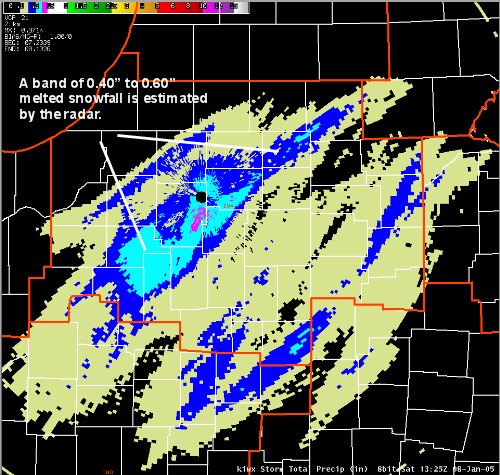 Figure 1 National Weather Service Digital Storm Total Precipitation ending at 825 am EST 01/08/05 |
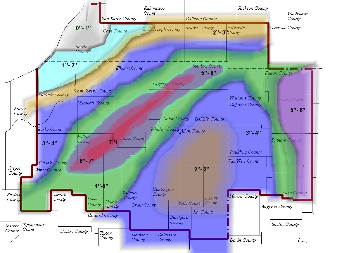 Figure 2 Hand contour analysis of observed snowfall via cooperative observers and snow spotters. |
The following are some specific snow reports from around the area
...SOUTHERN LOWER MICHIGAN...
COUNTY            CITY            SNOW IN INCHES
HILLSDALE         LITCHFIELD      2.7
BRANCH            QUINCY          2.5
CASS              NILES           1.2
BERRIEN           BUCHANAN        1.0
BERRIEN           EAU CLAIRE      1.0
BERRIEN           BENTON HARBOR   0.7
ST JOSEPH         WHITE PIGEON    2.3


...NORTHERN INDIANA...
COUNTY            CITY            SNOW IN INCHES
KOSCIUSKO         WARSAW          7.5
KOSCIUSKO         NORTH WEBSTER   7.5
KOSCIUSKO         SYRACUSE(NWS)   7.4
KOSCIUSKO         LEESBURG        7.2
NOBLE             CROMWELL        7.0
FULTON            ROCHESTER       7.0
KOSCIUSKO         SYRACUSE        7.0
KOSCIUSKO         MENTONE         6.0
FULTON            AKRON           6.0
CASS              LOGANSPORT      6.0
WHITE             MONTICELLO      6.0
NOBLE             KENDALLVILLE    6.0
STEUBEN           ANGOLA (NORTH)  6.0
STEUBEN           FREMONT         6.0
DEKALB            ASHLEY          5.1
DEKALB            WATERLOO        4.0
ELKHART           MIDDLEBURY      5.1
STEUBEN           ANGOLA (SOUTH)  5.0
STEUBEN           PLEASANT LAKE   5.0
CASS              LOGANSPORT      5.0
CASS              LOGANSPORT      6.0
STEUBEN           ANGOLA (WEST)   4.8
ELKHART           MILLERSBURG     4.5
DEKALB            AUBURN          4.0
BLACKFORD         HARTFORD CITY   4.0
ST. JOSEPH        SOUTH BEND ARPT 3.9
GRANT             MARION          3.8
WHITE             HEADLEE         3.8
ELKHART           ELKHART         3.5
ALLEN             MONROEVILLE     3.5
ELKHART           NEW PARIS       3.5
DEKALB            AUBURN          3.5
ALLEN             FORT WAYNE ARPT 3.2
ALLEN             FORT WAYNE      3.0
HUNTINGTON        HUNTINGTON      3.0
ALLEN             HOAGLAND        2.7
ST. JOSEPH        SOUTH BEND      2.5
ST. JOSEPH        NEW CARLISLE    1.5
LAPORTE           ROLLING PRAIRIE 1.3
LAPORTE           WESTVILLE       1.4
LAGRANGE          LAGRANGE        4.3
WHITLEY           COESSE          2.5
WHITLEY           COLUMBIA CITY   3.5
STEUBEN           METZ            3.5
STEUBEN           SALEM CENTER    5.0


...NORTHWESTERN OHIO...

COUNTY            CITY            SNOW IN INCHES
PUTNAM            COLUMBUS GROVE  5.6
HENRY             DESHLER         5.6
ALLEN             LIMA            5.0
PUTNAM            PANDORA         5.0
PUTNAM            OTTOVILLE       5.0
DEFIANCE          HICKSVILLE      3.0
VAN WERT          VAN WERT        3.5
PUTNAM            OTTAWA          4.0-6.0
VAN WERT          CONVOY          4.0

$$

A big thanks to those who relayed reports for this event.
TEH...01/09/05

