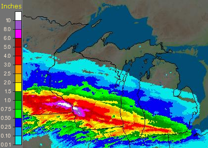
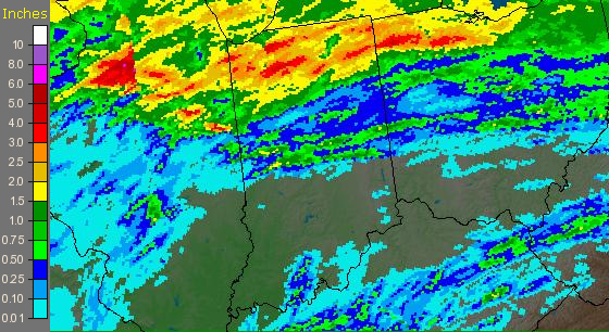
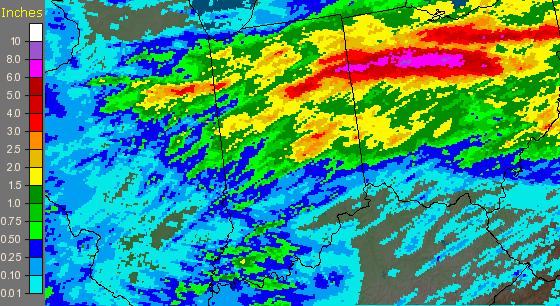
Heavy rainfall along a stationary front across the midwest the last few days has dropped substantial amounts of rainfall from the Upper Mississippi Valley into the Great Lakes and Ohio Valley. Below are maps of each of the last 3 days for the region, including maps of the local area. At the very bottom is a list of recorded rainfall amounts across the area from local observers and observation sites at local airports.
August 19
August 20
August 21
| Saturday | Sunday | Monday | Tuesday | Total | ||
| Ft. Wayne - FWA | IN | 0.00 | 0.71 | 3.40 | 1.58 | 5.69 |
| South Bend - SBN | IN | 0.07 | 0.60 | 1.43 | 0.00 | 2.10 |
| Lima - AOH | OH | 0.00 | 0.35 | 3.26 | 0.31 | 3.92 |
| Benton Harbor - BEH | MI | 0.17 | 2.52 | 0.94 | 0.01 | 3.64 |
| Defiance - DFI | OH | 0.03 | 0.88 | 5.93 | 0.31 | 7.15 |
| Goshen | IN | 0.07 | 0.70 | 2.77 | 0.01 | 3.55 |
| North Webster - IWX | IN | 0.06 | 0.88 | 4.11 | 0.02 | 5.07 |
| 0.00 | ||||||
| Warsaw (7-7) | IN | 0.00 | 0.09 | 2.19 | 3.10 | 5.38 |
| Angola (7-7) | IN | 0.00 | 0.02 | 2.82 | 2.08 | 4.92 |
| Napoleon (8-8) | OH | 0.00 | 0.49 | 3.38 | 1.98 | 5.85 |
| Knox (7-7) | IN | 0.00 | 0.06 | 2.62 | 1.31 | 3.99 |
| Marion (7-7) | IN | 0.00 | 0.01 | 0.25 | 2.72 | 2.98 |
| Rochester (7-7) | IN | 0.00 | 0.00 | 1.27 | 2.27 | 3.54 |
| Montpelier | OH | 0.00 | 1.00 | 2.23 | 1.99 | 5.22 |
| Bluffton | IN | 0.00 | 0.18 | 0.46 | 3.35 | 3.99 |
| 0.00 | ||||||
| 6 mi N of FWA | IN | 4.95 | ||||
| Pandora | OH | 0.00 | 0.00 | 2.03 | 6.18 | 8.21 |
| Columbus Grove | OH | 7.41 | 7.41 | |||
| Van Wert | OH | 7.50 | ||||
| 0.00 | ||||||
| Plymouth (7-7) | IN | 0.00 | 0.20 | 2.40 | 2.23 | 4.83 |
| Huntington (7-7) | IN | 0.00 | 0.00 | 0.77 | 4.31 | 5.08 |
| Berne (7-7) | IN | 0.00 | 0.21 | 0.31 | 3.08 | 3.60 |
| Monticello (7-7) | IN | 0.00 | 0.12 | 0.80 | 1.96 | 2.88 |
| Winona Lake (7-7) | IN | 0.00 | 0.00 | 3.42 | 1.84 | 5.26 |
| 3SE Ft Wayne (7-7) | IN | 0.00 | 0.01 | 0.73 | 5.32 | 6.06 |
|
(7-7) means a 24 hour total taken at 7am each morning. Tuesday amounts are as of 9am. |

