Northern Indiana
Weather Forecast Office
Much of the Northern Indiana County Warning Area saw some amount of snowfall since Sunday. A cold front moved through the area Sunday into Monday bringing higher snow amounts to Michigan, especially Berrien and Cass Counties. As a second wave of colder Canadian air spread across the Great Lakes Region Monday night into Tuesday, Lake Effect Snow hit Porter County the hardest, where upwards of 10 to 11 inches of snow fell, while other areas near Lake Michigan saw an additional 2-4 inches.
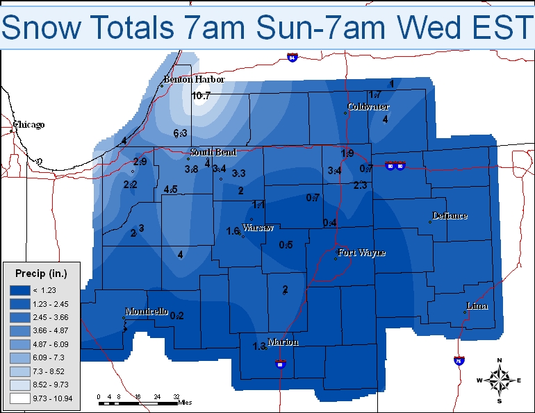
Indiana Locations    Snow Amounts
Porter 0.6 S             11.4
Valparaiso 0.4 SSW       10.5
Valparaiso 5.1 WSW       10.0
Valparaiso 5.9 NW         8.1
Kouts 2.8 N               7.5
Valparaiso 0.6 SE         7.5
Portage 0.9 ESE           7.0
Chesterton 3.0 ESE        6.8
La Porte                  6.1
Walkerton 5.7 ENE         4.5
Granger 2.9 W             4.1
Rochester 7.2 WNW         4.0
Mishawaka 3.9 ENE         4.0
South Bend 4.6 SE         3.8
De Motte 0.8 NNW          3.5
Elkhart 3.1 SSE           3.4
Hudson 4.6 N              3.4
Goshen 1.9 NW             3.3
Knox 1.2 S                3.0
Wakarusa 2.4 NNE          2.5
Hamilton 1.7 E            2.3
Kingsbury 0.3 WNW         2.2
New Paris 1.0 SSW         2.0
Huntington 0.3 W          2.0
Knox 4.1 SW               2.0
Angola 4.1 N              1.9
Warsaw 1.1 NNW            1.6
Marion 1.8 NW             1.3
Syracuse 3.0 ESE          1.1
Kendallville 0.2 W        0.7
Angola 8.7 ESE            0.7
Leesburg 4.7 E            0.6
Muncie 2.0 ESE            0.5
Columbia City 0.5 NNE     0.5
Fort Wayne 4.1 NE         0.4
Garrett 4.0 S             0.4
Logansport 0.8 E          0.2
Kokomo 4.6 ESE            0.1

Michigan Locations   Snow Amounts
Dowagic 5.3 NNW          10.7
Niles 2.7 W               6.3
Buchanan 1.4 ESE          6.1
New Buffalo 0.4 WNW       4.0
Hillsdale 3.2 SW          4.0
Jackson 1.2 NNE           4.0
Rolling Prairie           2.9
Litchfield 0.3 ENE        1.7
Hanover 3.8 W             1.0
WEISSER
Hazards
Heat Related
Winter Related
Watch/Warning
Outlook
Storm Reports
Storm Prediction Center
Submit a Report
Event Ready
Climate
FWA Daily
SBN Daily
FWA Monthly
SBN Monthly
CoCoRaHS
Spring Frost Climatology
Fall Frost Climatology
Severe Climatology
Local Information
Skywarn
COOP
Our Office
WSR-88D
Headline Criteria
NOAA Weather Radio
Weather History
Probabilistic Snowfall
Public Information Statement
Social Media Feeds
Weather Events Page
US Dept of Commerce
National Oceanic and Atmospheric Administration
National Weather Service
Northern Indiana
7506 E 850 N
Syracuse, IN 46567
574-834-1104
Comments? Questions? Please Contact Us.

