Northern Indiana
Weather Forecast Office
On the night of June 23rd, another round of severe weather affected the Northern Indiana forecast area. There was widespread wind damage across many counties including 7 confirmed tornadoes. Below are the maps concerning the damage tracks of the various tornadoes and microbursts confirmed in the Northern Indiana forecast area. Further information concerning the individual tornadoes can be found at the bottom of the page.
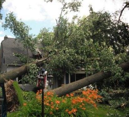
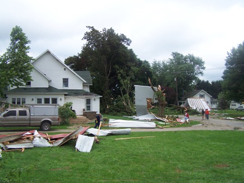
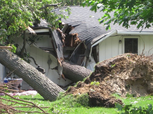
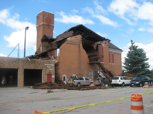
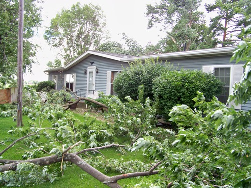
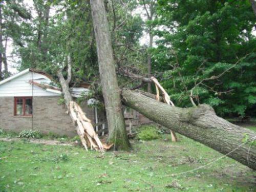
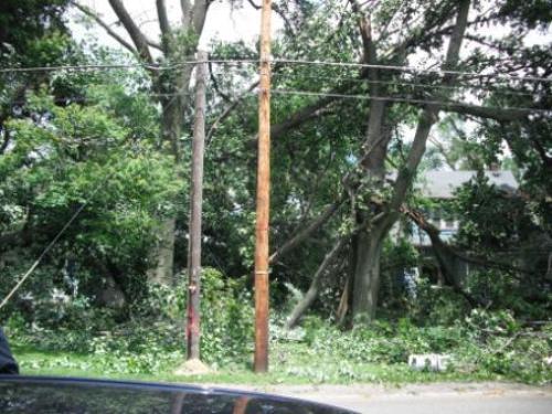
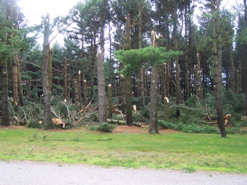
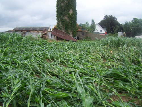
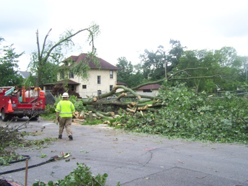
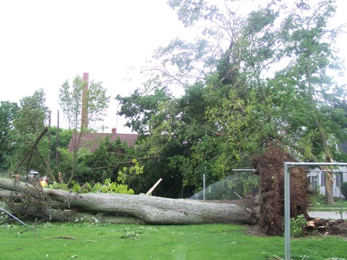
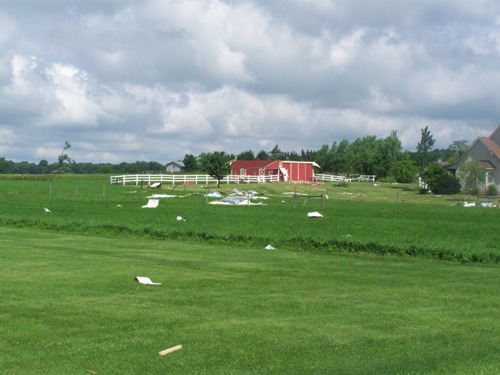
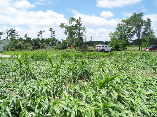
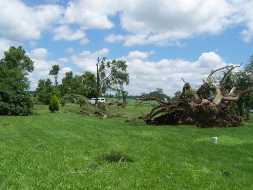
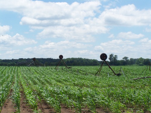
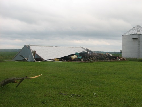
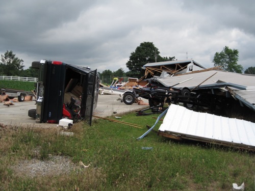
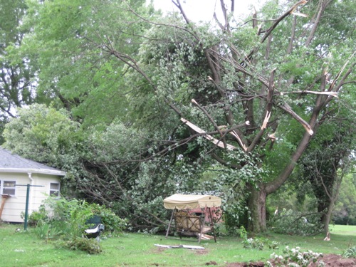
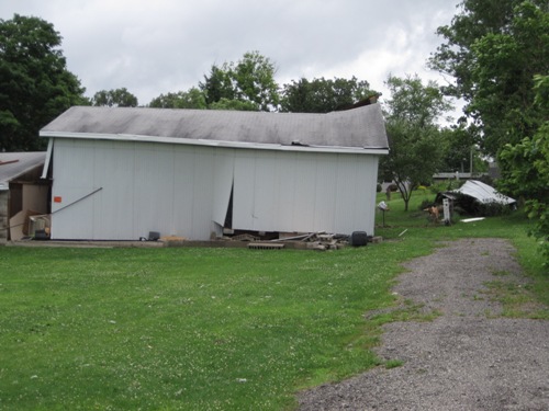
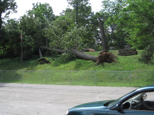
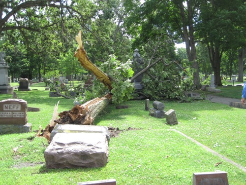
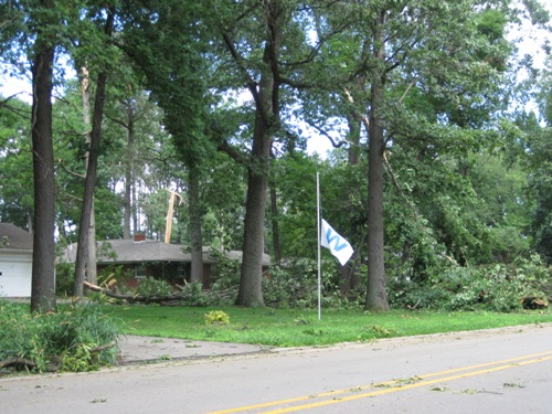
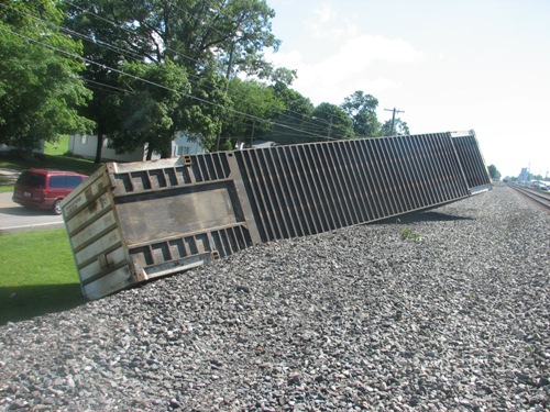
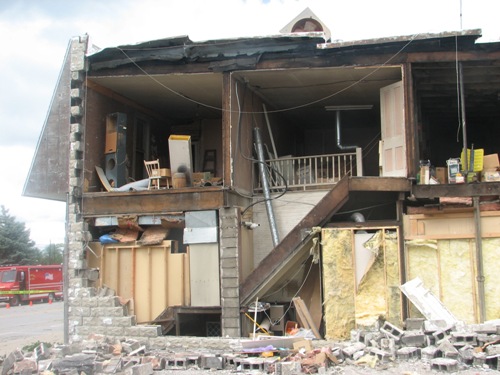
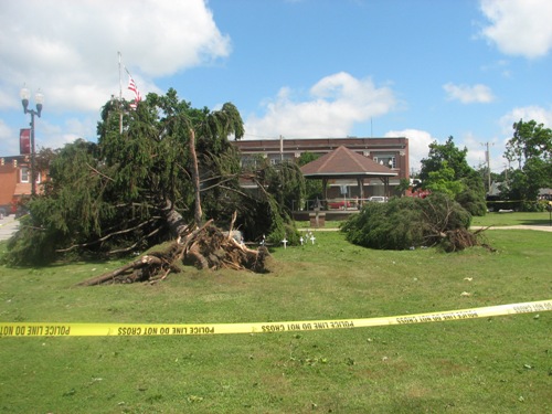
| Storm Damage Photos: | ||||
| LaPorte County Indiana | Elkhart County Indiana | Kosciusko County Indiana | Williams County Ohio | Van Wert Ohio |
(Click on an image for more photos from each county.)
The preliminary listing of all local storm reports across the country from SPC.
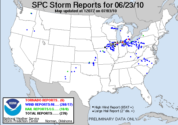
(Click here for a full list of severe reports from our area)
PRELIMINARY LOCAL STORM REPORT...SUMMARY
NATIONAL WEATHER SERVICE NORTHERN INDIANA
846 PM EDT SUN JUN 27 2010
..TIME... ...EVENT... ...CITY LOCATION... ...LAT.LON...
..DATE... ....MAG.... ..COUNTY LOCATION..ST.. ...SOURCE....
..REMARKS..
0203 PM TSTM WND GST MONROEVILLE 40.97N 84.87W
06/23/2010 E60 MPH ALLEN IN TRAINED SPOTTER
ESTIMATED 60 MPH WIND GUST
0205 PM TSTM WND GST PAULDING 41.14N 84.58W
06/23/2010 M61 MPH PAULDING OH EMERGENCY MNGR
WIND GUST RECORDED AT EMA OFFICE
0250 PM TSTM WND DMG 2 ENE KALIDA 40.99N 84.16W
06/23/2010 PUTNAM OH TRAINED SPOTTER
MULTIPLE TREES DOWN AT COUNTY RD M AND K-14 IN KALIDA
0255 PM TSTM WND DMG COLUMBUS GROVE 40.92N 84.06W
06/23/2010 PUTNAM OH TRAINED SPOTTER
24 TO 36 INCH DIAMETER HEALTHY TREE UPROOTED. NUMEROUS
LIMBS DOWN. POWER OUT.
0257 PM TSTM WND DMG 2 ENE COLUMBUS GROVE 40.93N 84.02W
06/23/2010 PUTNAM OH TRAINED SPOTTER
MULTIPLE TREE BRANCHES DOWN ACROSS STATE ROUTE 12
0805 PM MARINE TSTM WIND 2 NNW MICHIGAN CITY 41.74N 86.91W
06/23/2010 M64 MPH LMZ046 IN C-MAN STATION
56 KNOT GUST AT THE GLERL SITE AT MICHIGAN CITY
0812 PM TSTM WND DMG 3 E SPRINGVILLE 41.68N 86.68W
06/23/2010 LA PORTE IN BROADCAST MEDIA
WIDESPREAD WIND DAMAGE THROUGHOUT MUCH OF NORTHERN LA
PORTE COUNTY
0813 PM TSTM WND GST 2 SW LA PORTE 41.59N 86.75W
06/23/2010 M71 MPH LA PORTE IN TRAINED SPOTTER
POWER OUT AND BRANCHES DOWN
0813 PM TSTM WND DMG 2 E MICHIANA SHORES 41.76N 86.78W
06/23/2010 LA PORTE IN LAW ENFORCEMENT
SEMI-TRAILER BLOWN OVER BLOCKING PART OF INTERSTATE 94
0816 PM TSTM WND GST 4 N LAPORTE 41.67N 86.72W
06/23/2010 E90 MPH LA PORTE IN NWS EMPLOYEE
EXPERIENCED SUSTAINED 60 MPH WINDS FOR 10
MINUTES...WITH GUSTS UP TO 90 MPH
0829 PM TSTM WND GST 2 SW LAPORTE 41.59N 86.75W
06/23/2010 M59 MPH LA PORTE IN TRAINED SPOTTER
59 MPH GUSTS MEASURED
0841 PM TSTM WND GST N SOUTH BEND 41.68N 86.25W
06/23/2010 M68 MPH ST. JOSEPH IN TRAINED SPOTTER
MEASURED PEAK GUST OF 68 MPH
0845 PM TSTM WND GST KOONTZ LAKE 41.42N 86.49W
06/23/2010 E50 MPH STARKE IN AMATEUR RADIO
0846 PM TSTM WND GST SOUTH BEND 41.68N 86.25W
06/23/2010 E70 MPH ST. JOSEPH IN AMATEUR RADIO
ESTIMATED 60-70 MPH WIND GUSTS
0846 PM TSTM WND DMG 2 NW WOODLAND 41.59N 86.21W
06/23/2010 ST. JOSEPH IN BROADCAST MEDIA
DOWN TREE LIMBS ON ROAD...TWO CARS SWERVED TO AVOID
LIMBS ENDING UP IN A DITCH...INJURIES REPORTED
0848 PM TSTM WND GST 4 NW SOUTH BEND 41.72N 86.30W
06/23/2010 M60 MPH ST. JOSEPH IN ASOS
52 KT GUST AT 848 PM AT SOUTH BEND ASOS
0849 PM TSTM WND DMG SOUTH BEND 41.68N 86.25W
06/23/2010 ST. JOSEPH IN BROADCAST MEDIA
*** 2 INJ *** TREE DOWN ON HOUSE AT 600 BLOCK OF 28TH
ST...2 INJURED...RELAYED BY WNDU
0850 PM TSTM WND GST SOUTH BEND 41.68N 86.25W
06/23/2010 E65 MPH ST. JOSEPH IN TRAINED SPOTTER
ESTIMATED 65 MPH WIND GUST
0850 PM TSTM WND GST W SOUTH BEND 41.68N 86.25W
06/23/2010 M80 MPH ST. JOSEPH IN TRAINED SPOTTER
0852 PM TSTM WND GST 2 SE MISHAWAKA 41.64N 86.13W
06/23/2010 M84 MPH ST. JOSEPH IN TRAINED SPOTTER
84 MPH GUSTS MEASURED...VERY LARGE BRANCHES DOWN...LAWN
FURNITURE AND TRASH CANS EASILY BLOWN AROUND
0855 PM TSTM WND DMG SOUTH BEND 41.68N 86.25W
06/23/2010 ST. JOSEPH IN AMATEUR RADIO
ESTIMATED 40-50 MPH GUSTS...LARGE BRANCHES DOWN
0855 PM TSTM WND DMG 2 E WALKERTON 41.47N 86.44W
06/23/2010 MARSHALL IN BROADCAST MEDIA
LARGE TREE DOWN
0900 PM TORNADO 1 ENE WAKARUSA 41.54N 86.00W
06/23/2010 ELKHART IN NWS STORM SURVEY
EF1 TORNADO TOUCHED DOWN AT THE INTERSECTION OF HIGHWAY
19 AND COUNTRY ROAD 40. ROOF DAMAGE TO THE ULTA MASTER
PLANT. ADDITIONAL EF0 AND EF1 TORNADO DAMAGE REPORTED
ESE TOWARDS AND JUST SOUTH OF THE GOSHEN AIRPORT.
0907 PM TSTM WND GST 1 ESE UNION 41.78N 85.85W
06/23/2010 M80 MPH CASS MI TRAINED SPOTTER
MEASURED 80 MPH GUST WITH ANEMOMTER
0907 PM TORNADO GOSHEN 41.58N 85.83W
06/23/2010 ELKHART IN NWS STORM SURVEY
EFO TORNADO TOUCHED DOWN AT THE PARKSIDE ELEMENTARY
SCHOOL NEAR COUNTY ROAD 15. TREES UPROOTED AND SOME ROOF
DAMAGE.
0909 PM TSTM WND DMG MILLERSBURG 41.53N 85.69W
06/23/2010 ELKHART IN AMATEUR RADIO
SNAPPED 10 INCH DIAMETER TREES BLOCKING THE ROAD
0909 PM TSTM WND GST ELKHART 41.68N 85.98W
06/23/2010 E60 MPH ELKHART IN AMATEUR RADIO
WEAK ROTATION ALSO REPORTED
0911 PM TSTM WND GST N ELKHART 41.68N 85.98W
06/23/2010 M70 MPH ELKHART IN TRAINED SPOTTER
0911 PM TSTM WND GST W GOSHEN 41.58N 85.83W
06/23/2010 M50 MPH ELKHART IN TRAINED SPOTTER
0911 PM TSTM WND GST ROCHESTER 41.06N 86.22W
06/23/2010 M60 MPH FULTON IN AMATEUR RADIO
MEASURED 60 MPH GUST
0915 PM TORNADO E GOSHEN 41.58N 85.83W
06/23/2010 ELKHART IN NWS EMPLOYEE
TORNADO ON GROUND EAST OF GOSHEN ON CR42...DAMAGE
REPORTED
0915 PM TSTM WND DMG WARSAW 41.24N 85.85W
06/23/2010 KOSCIUSKO IN EMERGENCY MNGR
ROOF BLOWN OFF WARSAW FOUNDRY WHICH CREATED A GAS LEAK.
STRAIGHT LINE WINDS ALSO UPROOTED TREES AND CUT POWER TO
ABOUT A FOURTH OF THE CITY.
0917 PM TSTM WND GST ELKHART 41.68N 85.98W
06/23/2010 M47 MPH ELKHART IN TRAINED SPOTTER
47 MPH GUST MEASURED AT ELKHART CO FAIRGROUNDS
0919 PM TSTM WND DMG 1 NE WINONA LAKE 41.24N 85.80W
06/23/2010 KOSCIUSKO IN NWS EMPLOYEE
HEALTHY 1 FT DIAMETER MAPLE TREE SNAPPED AT BASE
0919 PM TSTM WND DMG WARSAW 41.24N 85.85W
06/23/2010 KOSCIUSKO IN NWS EMPLOYEE
NUMEROUS TREES DOWN ALONG OLD US30. POWER OUTAGES
SCATTERED ACROSS TOWN...INCLUDING MAJOR STOPLIGHTS AND
BUSINESSES.
0920 PM TSTM WND DMG BENTON 41.51N 85.76W
06/23/2010 ELKHART IN NWS EMPLOYEE
WIDESPREAD TREES DOWN AND HOUSE DAMAGED
0920 PM TSTM WND DMG GOSHEN 41.58N 85.83W
06/23/2010 ELKHART IN TRAINED SPOTTER
WIDESPREAD TREE DAMAGE ON CR 34 AND ALSO ON MAIN ST IN
GOSHEN
0920 PM TSTM WND DMG 4 NE SYRACUSE 41.47N 85.70W
06/23/2010 ELKHART IN NWS STORM SURVEY
LARGE UPROOTED TREE. LARGE TREE SNAPPED OFF. AREA OF
CORN FLATTENED. POLE BARN DOWN. DAMAGE NEAR US6 AND
CR43. STRAIGHT LINE WINDS ESTIMATED AT 90-100MPH.
0921 PM TSTM WND GST 2 N NORTH WEBSTER 41.36N 85.70W
06/23/2010 E65 MPH KOSCIUSKO IN NWS OFFICE
0921 PM TSTM WND DMG 3 SW MOTTVILLE 41.77N 85.80W
06/23/2010 CASS MI TRAINED SPOTTER
2 FT DIAMATER HEALTHY TREE DOWN ACROSS ROAD
0926 PM TSTM WND DMG LOGANSPORT 40.75N 86.36W
06/23/2010 CASS IN EMERGENCY MNGR
ROOF OF TOM HAYNES AUTOMOTIVE WAS BLOWN ONTO MAIN
FEEDER LINES FOR LOGANSPORT MINUCIPAL UTILITIES... WHICH
CAUSED EXTENSIVE POWER OUTAGES FOR MANY IN LOGANSPORT.
NUMEROUS TREES DOWN AND BLOCKING ROADWAYS.
0927 PM TSTM WND DMG 1 SW MOTTVILLE 41.79N 85.77W
06/23/2010 CASS MI TRAINED SPOTTER
MULTIPLE HEALTHY TREES LARGER THAN A FOOT DIAMETER DOWN
ACROSS ROAD MAKING ROAD IMPASSABLE
0929 PM TSTM WND DMG LITCHFIELD 42.04N 84.76W
06/23/2010 HILLSDALE MI EMERGENCY MNGR
WIDESPREAD TREE DAMAGE AND POWER OUTAGES
0930 PM LIGHTNING 1 N WHITE PIGEON 41.81N 85.64W
06/23/2010 ST. JOSEPH MI TRAINED SPOTTER
HOUSE ON DICKINSON RD STRUCK BY LIGHTNING AND ON FIRE.
0930 PM TSTM WND DMG 4 SSW WHITE PIGEON 41.74N 85.67W
06/23/2010 ELKHART IN TRAINED SPOTTER
3 FT DIAMETER TREE DOWN ACROSS ROAD. POWER LINES ALSO
DOWN. TRUCK RAN INTO TREE AND SUSTAINED DAMAGE
0930 PM TSTM WND DMG LITCHFIELD 42.04N 84.76W
06/23/2010 HILLSDALE MI EMERGENCY MNGR
FARM BARN FLATTENED AND PARTIAL ROOF OF FACTORY AT M49
AND HERRING RD....TIME ESTIMATED FROM RADAR
0933 PM TSTM WND DMG LEESBURG 41.33N 85.85W
06/23/2010 KOSCIUSKO IN NWS EMPLOYEE
LARGE TREES DOWN
0933 PM TSTM WND DMG COLDWATER 41.94N 85.00W
06/23/2010 BRANCH MI EMERGENCY MNGR
WIDESPREAD TREES AND POWER LINES DOWN IN COLDWATER...
SHERWOOD... GIRARD... AND BRONSON
0935 PM TSTM WND GST SYRACUSE 41.43N 85.75W
06/23/2010 E80 MPH KOSCIUSKO IN AMATEUR RADIO
TREE DOWN THROUGH HOUSE...TIME ESTIMATED FROM RADAR
0937 PM TSTM WND DMG LIGONIER 41.47N 85.59W
06/23/2010 NOBLE IN EMERGENCY MNGR
SEVERAL TREE LIMBS AND POWER LINES DOWN
0938 PM TSTM WND GST 1 W COLUMBIA CITY 41.16N 85.51W
06/23/2010 M75 MPH WHITLEY IN TRAINED SPOTTER
75 MPH GUST MEASURED AT LINCOLN WAY AND HWY 30
0940 PM WALL CLOUD 4 W COLUMBIA CITY 41.16N 85.57W
06/23/2010 WHITLEY IN AMATEUR RADIO
0940 PM TSTM WND DMG LAGRANGE 41.64N 85.42W
06/23/2010 LAGRANGE IN EMERGENCY MNGR
NUMEROUS TREES DOWN WITH SOME ON CARS. POWER LINES
DOWN. BARN DESTROYED.
0942 PM TSTM WND DMG W BENTON 41.51N 85.76W
06/23/2010 ELKHART IN TRAINED SPOTTER
TREE ON HOUSE ON CR-44. POWER LINES DOWN. TREES DOWN
ALL OVER COUNTY
0942 PM TSTM WND DMG URBANA 40.90N 85.79W
06/23/2010 WABASH IN EMERGENCY MNGR
SEVERAL TREES AND LINES DOWN WITH SOME ACROSS THE
ROADWAYS. WIDELY SCATTERED POWER OUTAGES.
0943 PM TSTM WND DMG COLUMBIA CITY 41.16N 85.49W
06/23/2010 WHITLEY IN LAW ENFORCEMENT
WIDESPREAD POWER OUTAGES TO ALL AREAS OUTSIDE OF
COLUMBIA CITY
0945 PM TSTM WND DMG LISBON 41.41N 85.26W
06/23/2010 NOBLE IN EMERGENCY MNGR
TREES AND LINES DOWN. OCCUPANT TRAPPED INSIDE.
0948 PM TSTM WND DMG 1 S PERU 40.74N 86.07W
06/23/2010 MIAMI IN EMERGENCY MNGR
TREE DOWN ON ST RD 19 SOUTH OF PERU
0948 PM TSTM WND DMG ALBION 41.40N 85.42W
06/23/2010 NOBLE IN EMERGENCY MNGR
TREE DOWN ON CAR. OCCUPANT TRAPPED INSIDE
0955 PM TSTM WND GST ALBION 41.40N 85.42W
06/23/2010 E60 MPH NOBLE IN AMATEUR RADIO
TREES DOWN ALL OVER...TIME ESTIMATED FROM RADAR
0956 PM TSTM WND GST HUNTINGTON 40.88N 85.50W
06/23/2010 M65 MPH HUNTINGTON IN EMERGENCY MNGR
REPORTS OF BRANCHES DOWN COUNTYWIDE
0956 PM TSTM WND DMG ALBION 41.40N 85.42W
06/23/2010 NOBLE IN AMATEUR RADIO
12 INCH BRANCHES DOWN AND 2 FOOT DIAMETER TREES
SNAPPED...TIME EST FROM RADAR
0958 PM TSTM WND GST HUNTINGTON 40.88N 85.50W
06/23/2010 E50 MPH HUNTINGTON IN TRAINED SPOTTER
SMALL LIMBS DOWN
0958 PM TSTM WND GST 1 W PLEASANT LAKE 41.58N 85.04W
06/23/2010 E51 MPH STEUBEN IN AMATEUR RADIO
6 INCH BRANCHES AND LARGE TREE DOWN
1001 PM FUNNEL CLOUD MONMOUTH 40.87N 84.94W
06/23/2010 ADAMS IN TRAINED SPOTTER
FUNNEL CLOUD SPOTTED AT PIQUA RD AND US 27
1001 PM TSTM WND DMG HUNTINGTON 40.88N 85.50W
06/23/2010 HUNTINGTON IN LAW ENFORCEMENT
ROOF PARTIALLY BLOWN OFF BUSINESS AT 239
HOWENSTEIN....TIME ESTIMATED FROM RADAR
1001 PM TSTM WND DMG HUNTINGTON 40.88N 85.50W
06/23/2010 HUNTINGTON IN LAW ENFORCEMENT
TREE DOWN ACROSS ROAD AT SR 5 AND YANCE
1005 PM TSTM WND DMG HUNTINGTON 40.88N 85.50W
06/23/2010 HUNTINGTON IN LAW ENFORCEMENT
MULTIPLE TREES DOWN AND WIDESPREAD POWER OUTAGES
1006 PM TSTM WND DMG 2 N PLEASANT LAKE 41.60N 85.02W
06/23/2010 STEUBEN IN LAW ENFORCEMENT
US 27 CLOSED DUE TO LARGE TREE DOWN BETWEEN PLEASANT
LAKE AND ANGOLA...WIDESPREAD POWER OUTAGES AND TREES
DOWN ACROSS COUNTY
1010 PM TSTM WND DMG EDGERTON 41.45N 84.75W
06/23/2010 WILLIAMS OH NWS STORM SURVEY
*** 1 INJ *** STRAIGHT LINE WIND DAMAGE WITH WINDS
ESTIMATED AT 100 MPH. TREES UPROOTED AND SNAPPED. TOWN
HALL ROOF PARTIALLY BLOWN OFF. WIND DAMAGE PATH ABOUT 3
MILES LONG AND A QUARTER OF A MILE WIDE.
1011 PM TSTM WND GST HAMILTON 41.53N 84.91W
06/23/2010 E60 MPH STEUBEN IN TRAINED SPOTTER
ESTIMATED 50-60 MPH GUSTS
1011 PM TSTM WND GST 2 NE FORT WAYNE 41.10N 85.11W
06/23/2010 M73 MPH ALLEN IN AMATEUR RADIO
MEASURED 73 MPH GUST NEAR STELLHORN RD.
1011 PM TSTM WND DMG CORUNNA 41.44N 85.15W
06/23/2010 DEKALB IN LAW ENFORCEMENT
MULTIPLE TREES AND POWER LINES DOWN AROUND TOWN...TIME
ESTIMATED FROM RADAR
1011 PM TSTM WND DMG 1 SSE WESTCHESTER 41.01N 85.12W
06/23/2010 ALLEN IN TRAINED SPOTTER
STREET LIGHT SNAPPED AT BASE
1011 PM TSTM WND DMG EDGERTON 41.45N 84.75W
06/23/2010 WILLIAMS OH TRAINED SPOTTER
COURT HOUSE DAMAGED. POSSIBLE TRAIN DERAILMENT AND TWO
SEMI RIGS RESTING AGAINST TRAIN...TIME ESTIMATED FROM
RADAR
1012 PM TSTM WND DMG W MARION 40.56N 85.66W
06/23/2010 GRANT IN TRAINED SPOTTER
WIDESPREAD POWER OUTAGES. MEASURED 47 MPH GUST WEST OF
MARION ON SR 18
1015 PM TSTM WND GST NEW HAVEN 41.07N 85.01W
06/23/2010 M62 MPH ALLEN IN AMATEUR RADIO
1019 PM FUNNEL CLOUD 2 NW FORT WAYNE 41.10N 85.16W
06/23/2010 ALLEN IN LAW ENFORCEMENT
FUNNEL CLOUD REPORTED AT ON W WASHINGTON CENTER NEAR
FLAUGH RD
1020 PM TSTM WND DMG SWEETSER 40.57N 85.77W
06/23/2010 GRANT IN TRAINED SPOTTER
TREES DOWN
1021 PM FUNNEL CLOUD FRONTIER 41.78N 84.60W
06/23/2010 HILLSDALE MI EMERGENCY MNGR
FUNNEL CLOUD SUSPENDED FROM WALL CLOUD
1022 PM TSTM WND GST WOODBURN 41.13N 84.85W
06/23/2010 M53 MPH ALLEN IN AMATEUR RADIO
1022 PM TSTM WND DMG FORT WAYNE 41.08N 85.13W
06/23/2010 ALLEN IN LAW ENFORCEMENT
SEMI OVERTURNED ON NORTHBOUND I469 MILEMARKER 19
1025 PM TSTM WND DMG MONROEVILLE 40.97N 84.87W
06/23/2010 ALLEN IN TRAINED SPOTTER
TREES AND BRANCHES DOWN
1028 PM TSTM WND GST MONROEVILLE 40.97N 84.87W
06/23/2010 E70 MPH ALLEN IN TRAINED SPOTTER
EST 60-70 MPH GUSTS
1030 PM TSTM WND DMG W BLUFFTON 40.74N 85.17W
06/23/2010 WELLS IN TRAINED SPOTTER
POWER OUT AND WIDESPREAD TREES DOWN
1030 PM TSTM WND DMG 3 N CONVOY 40.96N 84.71W
06/23/2010 VAN WERT OH EMERGENCY MNGR
NUMEROUS TREES DOWN
1035 PM TSTM WND DMG DEFIANCE 41.28N 84.36W
06/23/2010 DEFIANCE OH EMERGENCY MNGR
SEVERAL TREES DOWN
1035 PM TSTM WND DMG 1 S SCOTT 40.97N 84.58W
06/23/2010 VAN WERT OH EMERGENCY MNGR
TREE DOWN BLOCKING ROAD
1040 PM TSTM WND DMG 4 NW BLUFFTON 40.78N 85.23W
06/23/2010 WELLS IN LAW ENFORCEMENT
TREE DOWN AT INTERSECTION 400 N AND 100 E...POWER OUT
TO MOST OF COUNTY
1040 PM TSTM WND DMG LATTY 41.09N 84.59W
06/23/2010 PAULDING OH EMERGENCY MNGR
POWER LINES AND SMALL TREE BRANCHES DOWN...TIME
ESTIMATED FROM RADAR
1059 PM TSTM WND GST DELPHOS 40.84N 84.34W
06/23/2010 M62 MPH ALLEN OH AMATEUR RADIO
1100 PM FUNNEL CLOUD DELTA 41.57N 84.01W
06/23/2010 FULTON OH LAW ENFORCEMENT
FUNNEL CLOUD REPORT RELAYED BY LAW ENFORCEMENT
1103 PM TSTM WND DMG 3 E LIBERTY CENTER 41.44N 83.95W
06/23/2010 HENRY OH EMERGENCY MNGR
POWER LINES DOWN AND POWER OUT AT CO RD T AND CO RD 4
1108 PM TSTM WND DMG 3 SW MCCLURE 41.34N 83.98W
06/23/2010 HENRY OH EMERGENCY MNGR
TREES AND POWER LINES DOWN AT CTY RD M4 AND CTY RD
7...TIME ESTIMATED FROM RADAR
PUBLIC INFORMATION STATEMENT...UPDATED
NATIONAL WEATHER SERVICE NORTHERN INDIANA
332 PM EDT FRI JUN 25 2010 /232 PM CDT FRI JUN 25 2010/

....PUBLIC INFORMATION STATEMENT...

THE FIRST TORNADO WAS SURVEYED AS AN EF1 WHICH TOUCHED DOWN JUST
NORTHWEST OF WAKARUSA NEAR THE INTERSECTION OF CR1 NORTH OF CR38 AND
CONTINUED EAST-SOUTHEAST FOR 11 MILES TO JUST SOUTHWEST OF THE
GOSHEN AIRPORT BEFORE LIFTING.

JUST EAST OF HERE A MICROBURST WAS NOTED IN THE TOWN OF BENTON WITH
A NEW EF1 TORNADO TRACK BEGINNING JUST NORTH OF CR42 ON CR31. THIS
SECOND TORNADO TRACKED EAST-SOUTHEAST FOR 4 MILES TO JUST SOUTH OF
MILLERSBURG HITTING THE TIMBER RIDGE GOLF COURSE BEFORE LIFTING NEAR
THE INTERSECTION OF CR46 AND SR13.

A THIRD TORNADO DEVELOPED ON THE NORTH SIDE OF ANOTHER MICROBURST
NOTED IN THE TOWN OF SYRACUSE JUST NORTH OF US6 AND WEST OF CR33.
THIS TORNADO WAS OF EF0 INTENSITY AND TRACKED EAST-SOUTHEAST FOR 4
MILES...CROSSING US6 BEFORE LIFTING JUST WEST OF CR43.

A FOURTH TORNADO WAS SURVEYED AS A EF0 WHICH DEVELOPED NEAR THE
PARKSIDE ELEMENTARY SCHOOL AND TRACKED ABOUT 4 BLOCKS WITH A 100
YARD WIDE PATH THROUGH THE SOUTH SIDE OF GOSHEN BEFORE LIFTING NEAR
THE RAILROAD TRACKS JUST EAST OF SR15. THIS TORNADO WAS EMBEDDED
WITHIN A LARGER SCALE MICROBURST.

A FIFTH TORNADO WAS REPORTED TO ELKHART COUNTY EMA OFFICIALS IN THE
13000 BLOCK OF COUNTY ROAD 22. EYEWITNESSES REPORTED A CIRCULATION
TOUCH DOWN IN A OPEN FIELD AND MOVE RAPIDLY EAST. AS IT DID...SEVERE
ROOF AND TRUSS DAMAGE WAS DONE TO A MILKING BARN WITH THE MATERIALS
BEING OBSERVED CARRIED NEARLY A MILE TO THE EAST BEFORE BEING
DEPOSITED. THE CIRCULATION QUICKLY LOST STRENGTH AT THIS POINT.
WHILE FURTHER ASSESSMENT NEEDS TO BE COMPLETED...AN INITIAL RATING
OF AN EF0 WITH WINDS OF 80 MPH HAS BEEN ASSIGNED.
PUBLIC INFORMATION STATEMENT...UPDATED
NATIONAL WEATHER SERVICE NORTHERN INDIANA
332 PM EDT FRI JUN 25 2010 /232 PM CDT FRI JUN 25 2010/

....PUBLIC INFORMATION STATEMENT...

LAPORTE COUNTY, IN

WIDESPREAD DAMAGING WINDS WERE FOUND HERE. AN INTENSE MICROBURST
WITH A PATH OF 2 TO 3 MILES AND 100 MPH WINDS WAS SURVEYED FROM
PINE LAKE NORTHEAST THROUGH ROLLING PRAIRIE. ENUMERABLE TREES
UPROOTED AND SNAPPED WITH ROOF DAMAGE TO NUMEROUS HOMES.
PUBLIC INFORMATION STATEMENT...UPDATED
NATIONAL WEATHER SERVICE NORTHERN INDIANA
332 PM EDT FRI JUN 25 2010 /232 PM CDT FRI JUN 25 2010/

....PUBLIC INFORMATION STATEMENT...

KOSCIUSKO COUNTY, IN

AN EF1 TORNADO WAS SURVEYED WITH A MAX PATH WIDTH OF 125 YARDS AND
PATH LENGTH OF 4.3 MILES.

A MICROBURST WAS NOTED 1/4 MILE SOUTH OF 200W AND FOX FARM ROAD WITH
A LARGE STORAGE OUTBUILDING PARTIALLY DESTROYED, PICKUP TRUCK
FLIPPED OVER AND SEVERAL TREES UPROOTED. WINDS HERE WERE ESTIMATED
AT 100 MPH. THIS MICROBURST LED TO THE RAPID DEVELOPMENT OF AN EF0
TORNADO WHICH SUBSEQUENTLY DEVELOPED JUST TO ITS EAST...WEST OF THE
CENTER LAKE WETLAND CONSERVATION AREA. THIS TORNADO TRACKED
EAST-SOUTHEAST FOR 4 MILES THROUGH THE NORTH SIDE OF WARSAW BEFORE
LIFTING ON OLD US30 JUST WEST OF 250E REACHING EF1 INTENSITY WITH A
PATH WIDTH OF 100 YARDS JUST EAST OF CENTER LAKE AND CAUSING
EXTENSIVE ROOF DAMAGE TO THE WARSAW FOUNDRY. IN ADDITION THE
ADVANCED AUTOPARTS STORE SUFFERED MINOR DAMAGE WITH MORE EXTENSIVE
TREE DAMAGE NEAR BY. THE TORNADO CONTINUED EAST...ACROSS THE
RAILROAD TRACKS HITTING A STORAGE BUILDING CAUSING SIGNIFICANT
DAMAGE AND SHIFTING THE BUILDING OFF ITS FOUNDATION. ADDITIONAL
MINOR STRUCTURAL DAMAGE EXTENDED EAST TO PIKE LAKE WITH WIDESPREAD
SIGNIFICANT TREE DAMAGE INCLUDING TOPPED AND UPROOTED TREES. THIS
TORNADO CROSSED PIKE LAKE JUST MISSING THE PIKE LAKE RV CAMPGROUND
BUT DID HIT OAKWOOD CEMETERY WITH EXTENSIVE DAMAGE TO TREES AND
GRAVE MARKERS NOTED. THE TORNADO THEN CROSSED HARRISON STREET JUST
SOUTH OF THE KCH HOSPITAL AND REACHED ITS MAXIMUM PATH WIDTH OF 125
YARDS CAUSING SEVERE TREE DAMAGE TO NUMEROUS MATURE HARDWOOD TREES
WITH TREES SNAPPED...UPROOTED AND TOPPED. MANY HOUSES SUFFERED MINOR
TO SEVERE STRUCTURAL DAMAGE FROM HERE EASTWARD TO PARKER STREET
BECAUSE OF THE CONSIDERABLE TREE DAMAGE THAT OCCURRED. FROM THIS
POINT ON THE TORNADO WEAKENED QUICKLY WITH LESSENING DAMAGE AS IT
CROSSED US30 BEFORE LIFTING JUST EAST OF TOWN.
PUBLIC INFORMATION STATEMENT...UPDATED
NATIONAL WEATHER SERVICE NORTHERN INDIANA
332 PM EDT FRI JUN 25 2010 /232 PM CDT FRI JUN 25 2010/

....PUBLIC INFORMATION STATEMENT...

VAN WERT COUNTY, OH

A BRIEF EF0 TORNADO WAS SURVEYED WITH A MAXIMUM PATH WIDTH OF 50
YARDS AND PATH LENGTH OF 1.2 MILES.

THIS TORNADO STARTED IN A WHEAT FIELD APPROXIMATELY 1/4 MILE WEST OF
DUSTMAN DRIVE WEST OF US 127 AND CONTINUED 1.2 MILES TO THE EAST TO
BEFORE LIFTING EAST US 127. 4 HOMES SUFFERED MINOR DAMAGE BUT
EXTENSIVE TREE DAMAGE WAS WIDESPREAD. IN ADDITION A PORTION OF A
ROOF WAS TORN OFF A BARN NEAR US 127.
PUBLIC INFORMATION STATEMENT...UPDATED
NATIONAL WEATHER SERVICE NORTHERN INDIANA
332 PM EDT FRI JUN 25 2010 /232 PM CDT FRI JUN 25 2010/

....PUBLIC INFORMATION STATEMENT...

WIDESPREAD DAMAGING WINDS WERE FOUND HERE. AN INTENSE MICROBURST WAS
SURVEYED IN THE TOWN OF EDGERTON. A LARGE PORTION OF THE UPPER STORY
WAS BLOWN IN WITH LOSS OF MUCH OF THE ROOF OF THE OLD TOWN HALL
BUILDING NEXT TO THE FIRE DEPARTMENT. DEBRIS FROM THIS STRUCTURE
DAMAGED NEARBY VEHICLES AND THE FLEA MARKET BUILDING ACROSS THE
STREET INCLUDING A PORTION OF THE SOUTH FACING WALL GETTING BLOWN
OUT. ONE PERSON WAS INJURED AT THIS LOCATION FROM THE FALLING
DEBRIS. IN ADDITION A FREIGHT CONTAINER WAS BLOWN OFF AN INTERMODAL
TRAIN WITH SIGNIFICANT TREE DAMAGE IN TOWN.
WEISSER/HOLSTEN
Hazards
Heat Related
Winter Related
Watch/Warning
Outlook
Storm Reports
Storm Prediction Center
Submit a Report
Event Ready
Climate
FWA Daily
SBN Daily
FWA Monthly
SBN Monthly
CoCoRaHS
Spring Frost Climatology
Fall Frost Climatology
Severe Climatology
Local Information
Skywarn
COOP
Our Office
WSR-88D
Headline Criteria
NOAA Weather Radio
Weather History
Probabilistic Snowfall
Public Information Statement
Social Media Feeds
Weather Events Page
US Dept of Commerce
National Oceanic and Atmospheric Administration
National Weather Service
Northern Indiana
7506 E 850 N
Syracuse, IN 46567
574-834-1104
Comments? Questions? Please Contact Us.

