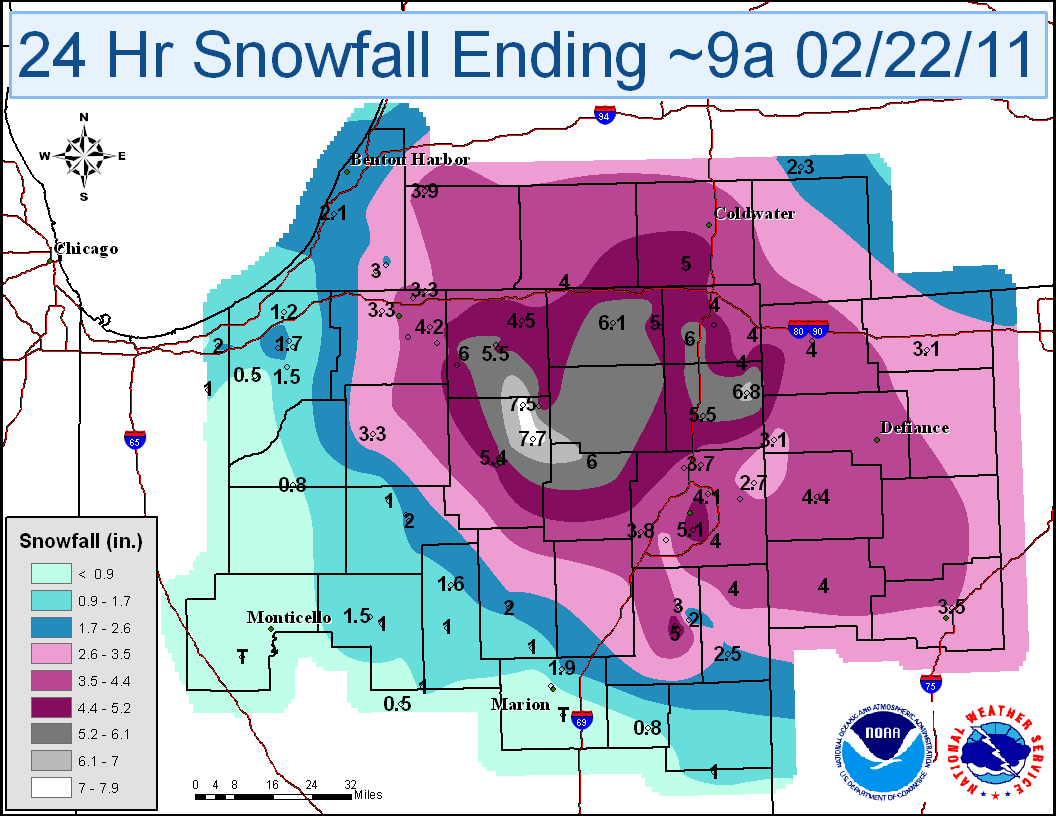
A low pressure system tracked east across the Ohio Valley and brought a mixture of freezing rain, sleet, and snow to the forecast area. Heaviest hit areas received 3 to up to 8 inches of snow on February 21st.
| Location | Value |
| LEESBURG 6.7 ESE | 7.7 |
| SYRACUSE 0.9 SW | 7.5 |
| BUTLER 0.5 NNE | 6.8 |
| LAGRANGE 1.3 ENE | 6.1 |
| COLUMBIA CITY 5.4 N | 6.0 |
| HUDSON 4.6 N | 6.0 |
| WAKARUSA 2.4 NNE | 6.0 |
| AUBURN 0.8 NE | 5.5 |
| GOSHEN 1.9 NW | 5.5 |
| HUDSON 4.1 NNW | 5.4 |
| WARSAW 1.1 NNW | 5.4 |
| FORT WAYNE 4.0 SE | 5.1 |
| BLUFFTON 0.9 SE | 5.0 |
| BLUFFTON 1 N | 5.0 |
| BRONSON 5.9 SE | 5.0 |
| LAGRANGE 9.9 E | 5.0 |
| WAKARUSA 0.3 WSW | 5.0 |
| GOSHEN 1.2 WNW | 4.9 |
| SYRACUSE 3.0 ESE | 4.9 |
| ANGOLA | 4.7 |
| MIDDLEBURY 2.6 WSW | 4.5 |
| ORLAND 6.6 SSW | 4.5 |
| WARSAW AWOS | 4.5 |
| PAULDING | 4.4 |
| GRANGER 2.9 W | 4.2 |
| MISHAWAKA 2.5 SE | 4.2 |
| FORT WAYNE 7.0 NE | 4.1 |
| HUNTERTOWN 2.6 ESE | 4.1 |
| ANGOLA 4.1 N | 4.0 |
| ANGOLA 8.7 ESE | 4.0 |
| DECATUR 1 N | 4.0 |
| FORT WAYNE 9.1 SE | 4.0 |
| HAMILTON 1.7 E | 4.0 |
| MONTPELIER 0.6 NW | 4.0 |
| VAN WERT 1 S | 4.0 |
| WHITE PIGEON 3.4 ESE | 4.0 |
| DOWAGIAC 5.3 NNW | 3.9 |
| WOODBURN 2.8 WSW | 3.9 |
| FORT WAYNE 9.0 WSW | 3.8 |
| LEO 2.2 NW | 3.7 |
| SOUTH BEND 4.6 SE | 3.6 |
| LIMA 2.7 NE | 3.5 |
| MISHAWAKA 5.9 SE | 3.4 |
| FORT WAYNE ASOS | 3.3 |
| GRANGER 1.6 N | 3.3 |
| PLYMOUTH 2.5 WSW | 3.3 |
| SOUTH BEND ASOS | 3.3 |
| HICKSVILLE | 3.1 |
| WAUSEON | 3.1 |
| BLUFFTON 4.1 N | 3.0 |
| BUCHANAN 1.4 ESE | 3.0 |
| LA PORTE 1.6 SW | 2.7 |
| WOODBURN 3 N | 2.7 |
| BERNE 0.8 WSW | 2.5 |
| NILES 2.7 W | 2.5 |
| WABASH 1.2 NNW | 2.5 |
| HANOVER 3.8 W | 2.3 |
| ROCHESTER 2.4 NW | 2.2 |
| STEVENSVILLE 1.7 SSE | 2.1 |
| BLUFFTON 3.0 ENE | 2.0 |
| CHESTERTON 4.2 E | 2.0 |
| ROCHESTER | 2.0 |
| WABASH 0.3 NNW | 2.0 |
| MARION 5.4 NNE | 1.9 |
| LA PORTE 1.2 E | 1.7 |
| DENVER 1.3 NE | 1.6 |
| KINGSBURY 1 N | 1.5 |
| LOGANSPORT 2.2 NNW | 1.5 |
| LA PORTE 6.2 N | 1.2 |
| GALVESTON 1.3 ESE | 1.0 |
| LA FONTAINE 1.1 NW | 1.0 |
| LOGANSPORT 1.7 ENE | 1.0 |
| PERU | 1.0 |
| RIDGEVILLE 1 N | 1.0 |
| ROCHESTER 7.0 NW | 1.0 |
| VALPARAISO 2.0 ESE | 1.0 |
| HARTFORD CITY 4 ESE | 0.8 |
| LA PORTE 2.3 ESE | 0.8 |
| MARION 2 N | 0.8 |
| NORTH JUDSON 5.7 ESE | 0.8 |
| KOKOMO 7.2 WNW | 0.5 |
| WESTVILLE 4.7 ESE | 0.5 |
| CHALMERS 5 W | 0.0 |
| GAS CITY 0.9 SW | 0.0 |
Data sources: CoCoRaHS, Cooperative Observers, Spotters and ASOS

