
Updated 7/9/2014 12:15 am EDT
A line of severe thunderstorms moved through the region during the overnight/early morning hours of July 1st, 2014. Widespread straight-line wind damage resulted across much of northern Indiana and southwest lower Michigan before the storms weakened over northwest Ohio. In coordination with local emergency management across most of our counties, damage surveys were completed in the hardest hit areas. 11 tornadoes have been confirmed with straight-line wind damage determined to be the cause in other locations across northern Indiana and southwest lower Michigan. An overview of the damage survey can be found here.
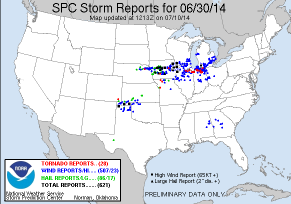
Widespread wind damage was reported from Iowa all the way into eastern lower Michigan. Several tornadoes have been confirmed via damage surveys over the past few days. Hail reports were mainly contained to Iowa although a few large hail reports did come in from Illinois and Indiana.
As of 4 pm EDT July 4, 2014, 11 tornadoes have been confirmed in northern Indiana. 10 of these were rated EF-1 and one was rated EF-0. Other damage surveys across the area revealed significant straight-line wind damage. The details for each tornado, including path maps, and wind damage surveys follow. This information is released in a Public Information Statement. The latest statement is available here.
NOUS43 KIWX 041938
PNSIWX
INZ003>009-012>018-020-022>027-032>034-MIZ077>081-OHZ001-002-004-
005-015-016-024-025-051800-
PUBLIC INFORMATION STATEMENT
NATIONAL WEATHER SERVICE NORTHERN INDIANA
338 PM EDT FRI JUL 4 2014 /238 PM CDT FRI JUL 4 2014/
...NWS DAMAGE SURVEY FOR 7/01/14 SEVERE WEATHER EVENT - UPDATE
10...
.UPDATE...
CONFIRMATION OF 4 ADDITIONAL TORNADOES...2 IN LAPORTE COUNTY...1 IN
STARKE COUNTY...AND 1 IN STARKE INTO MARSHALL COUNTY. IN ADDITION A
WESTERN EXTENSTION WAS FOUND ON EXISITING TORNADO #3 IN MARSHALL
COUNTY WITH AN UPGRADE IN RATING TO EF-1.
.OVERVIEW...
A LINE OF SEVERE THUNDERSTORMS MOVED THROUGH THE REGION DURING THE
OVERNIGHT/EARLY MORNING HOURS OF JUL 01 2014. NWS SURVEY CREWS
WERE DISPATCHED TO ASSESS THE DAMAGE ACROSS PORTIONS OF THE
AREA...INCLUDING
ELKHART...LAGRANGE...LAPORTE...KOSCIUSKO...MARSHALL...SAINT
JOSEPH...STARKE...WABASH ...AND WHITLEY COUNTIES IN INDIANA. AS A
RESULT OF THE SURVEYS...11 TORNADOES WERE CONFIRMED. ALL OTHER
SURVEYS CONDUCTED DETERMINED DAMAGE PRODUCED BY STRAIGHT LINE WINDS.
THIS STATEMENT IS PRELIMINARY AND WILL BE UPDATED IF MORE
INFORMATION BECOMES AVAILABLE. OTHERWISE THIS WILL BE THE FINAL
STATEMENT FOR THIS EVENT.
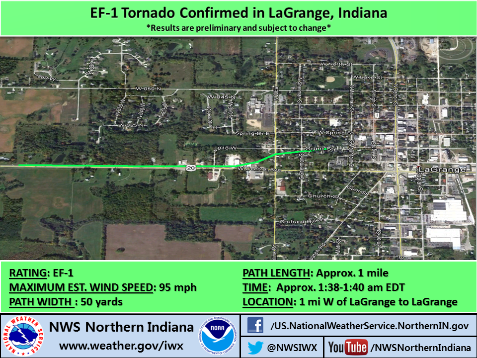
.TORNADO #1 - LAGRANGE COUNTY...
RATING: EF-1
ESTIMATED PEAK WIND: 95 MPH
PATH LENGTH /STATUTE/: AROUND 1 MILE
MILES PATH WIDTH /MAXIMUM/: EST. 50 YARDS
FATALITIES: NONE
INJURIES: NONE
START DATE: JUL 01 2014
TIME: EST. 138 AM EDT
START LOCATION: 1 MI WSW OF LAGRANGE, IN
START LAT/LON: 41.6414 / -85.4399
END DATE: JUL 01 2014
END TIME: EST. 140 AM EDT
END LOCATION: LAGRANGE, IN
END LAT/LON: 41.6428 / -85.4218
SURVEY SUMMARY: A TORNADO TOUCHED DOWN JUST WEST OF LAGRANGE ON
U.S. 20 AROUND 130 AM EDT...WHERE TREE LIMB DAMAGE WAS OBSERVED.
THE TORNADO TRACKED EAST TOWARD LAGRANGE...UPROOTING TREES AS IT
ENTERED THE TOWN SOUTH OF THE HOSPITAL. NUMEROUS TREES WERE
UPROOTED AND SNAPPED JUST WEST OF S COUNTY ROAD 00 E BETWEEN
U.S. 20 AND GRANT STREET. THE TORNADO PRODUCED MINOR STRUCTURAL
DAMAGE TO HOMES ALONG GRANT STREET BEFORE LIFTING JUST WEST OF S
MOUNTAIN STREET. THIS TORNADO WAS EMBEDDED ALONG THE NORTH FLANK OF
A MUCH LARGER ONE MILE WIDE SWATH OF INTENSE DAMAGING WINDS OF 70-80
MPH ALONG AND SOUTH OF HIGHWAY 20 IN LAGRANGE. ESTIMATED WINDS WITH
THE TORNADO WERE 95 MPH.
.TORNADO #2 - KOSCIUSKO COUNTY...
RATING: EF-0
ESTIMATED PEAK WIND: 80 MPH
PATH LENGTH /STATUTE/: 1.9 MILES
MILES PATH WIDTH /MAXIMUM/: EST. 50 YARDS
FATALITIES: NONE
INJURIES: NONE
START DATE: JUL 01 2014
TIME: EST. 106 AM EDT
START LOCATION: 3.5 MI W OF MILFORD, IN
START LAT/LON: 41.4122 / -85.9188
END DATE: JUL 01 2014
END TIME: EST. 108 AM EDT
END LOCATION: 2.2 MI WNW MILFORD, IN
END LAT/LON: 41.4194 / -85.8855
SURVEY SUMMARY: A TORNADO TOUCHED DOWN JUST SOUTH OF CR 1250N AND
EAST OF CR 400W AROUND 106 AM EDT...WHERE A LARGE METAL FARM
BUILDING WAS DESTROYED. TORNADO CROSSED CR 1250N AND WENT THROUGH A
CORN FIELD AND THEN DESTROYED A BARN NEAR 200W NORTH OF CR 1250N
WITH MISSILE DEBRIS SCATTERED TO THE EAST ACROSS 200W AND INTO
ANOTHER CORN FIELD WHERE THE CIRCULATION LIFTED AND OR DISSIPATED.
.TORNADO #3 - MARSHALL COUNTY...
RATING: EF-1
ESTIMATED PEAK WIND: 105 MPH
PATH LENGTH /STATUTE/: APPROX 7 MILES
MILES PATH WIDTH /MAXIMUM/: EST. 150 YARDS
FATALITIES: NONE
INJURIES: NONE
START DATE: JUL 01 2014
TIME: EST. 1235 AM EDT
START LOCATION: 1 MI S OF DONALDSON, IN
START LAT/LON: 41.346 / -86.4435
END DATE: JUL 01 2014
END TIME: EST. 1242 AM EDT
END LOCATION: 1 MI N OF PLYMOUTH, IN
END LAT/LON: 41.361 / -86.3138
SURVEY SUMMARY: AN EF-1 TORNADO TOUCHED DOWN JUST SOUTH OF DONALDSON
WHERE IT CAUSED EXTENSIVE DAMAGE TO HARDWOOD TREES. THE TORNADO
MOVED EAST AND HEAVILY DAMAGED A FARM ON SYCAMORE ROAD JUST SOUTH OF
THE RAILROAD TRACKS. EXTENSIVE TREE DAMAGE CONTINUED TO THE
EAST/NORTHEAST INTO THE TOWN OF PLYMOUTH TO THE LEAR CORPORATION
WHERE MULTIPLE TREES WERE SNAPPED AND TOPPED. AN EMPTY SEMI TRAILER
WAS FLIPPED. THE TORNADO CONTINUED NE WITH WIDESPREAD MIXED
HARDWOOD/SOFTWOOD TREE DAMAGE AND MINOR STRUCTURAL DAMAGE TO THE
BEHAVIOR SCIENCE BUILDING ON N OAK ROAD. THE TORNADO CAUSED PARTIAL
UPLIFT OF THE NW SIDE OF THE ROOF AND COLLAPSED THE INTERIOR CINDER
BLOCK WALL ON THE EAST SIDE OF THE DEPT OF TRANSPORTATION GARAGE
JUST SOUTH OF US 30 BEFORE LIFTING.
.TORNADO #4 - MARSHALL COUNTY...
RATING: EF-1
ESTIMATED PEAK WIND: 95 MPH
PATH LENGTH /STATUTE/: APPROX 0.2 MILES
MILES PATH WIDTH /MAXIMUM/: EST. 50 YARDS
FATALITIES: NONE
INJURIES: NONE
START DATE: JUL 01 2014
TIME: EST. 1241 AM EDT
START LOCATION: 2 MI NE OF PLYMOUTH, IN
START LAT/LON: 41.361 / -86.2893
END DATE: JUL 01 2014
END TIME: EST. 1242 AM EDT
END LOCATION: 2.2 MI NE OF PLYMOUTH, IN
END LAT/LON: 41.3629 / -86.2875
SURVEY SUMMARY: A BRIEF EF-1 TORNADO TOUCHED DOWN NEAR THE
INTERSECTION OF LILAC ROAD AND PLYMOUTH GOSHEN TRAIL JUST NE OF
PLYMOUTH AROUND 1241 AM EDT. HARDWOOD TREE DAMAGE WAS NOTED IN THIS
LOCATION WITH SEVERAL UPROOTED TREES AND A SHED WAS FLATTENED. AS
THE CIRCULATION MOVED NE IT SHIFTED A BARN OFF ITS FOUNDATION AND
CAUSED WIDESPREAD SEVERE TREE DAMAGE IN A GROVE OF TREES BEFORE
LIFTING IN A FIELD ON THE OTHER SIDE OF THE TREE GROVE.
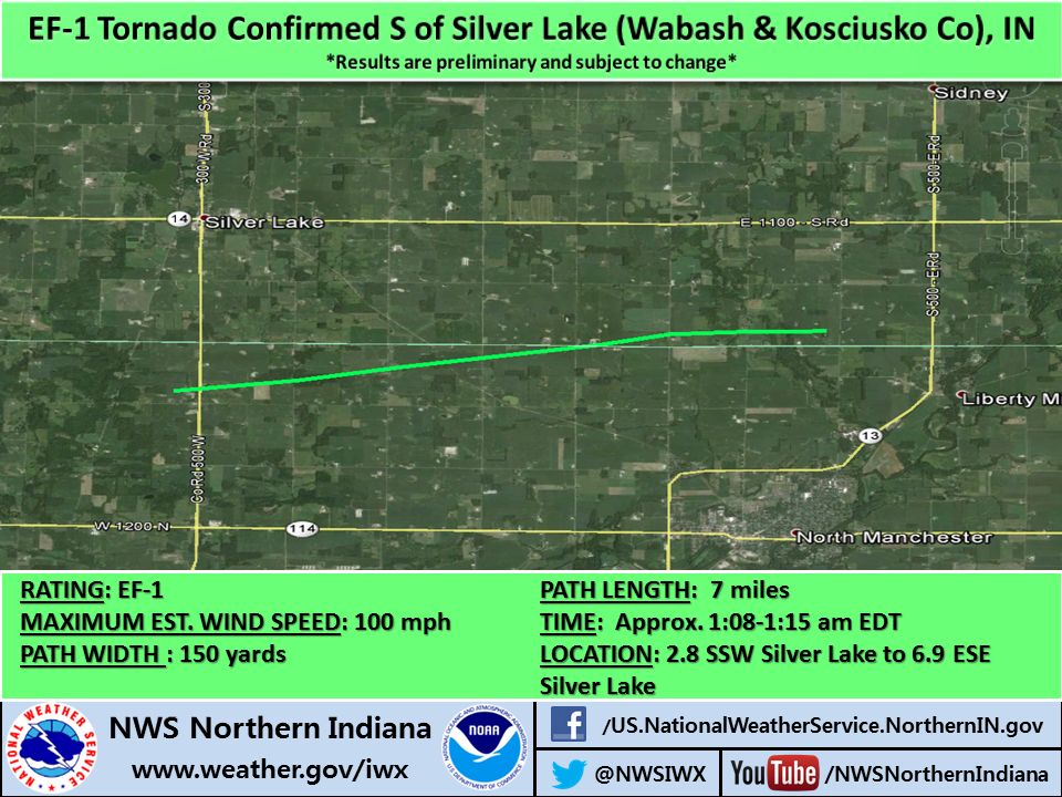
.TORNADO #5 - WABASH/KOSCIUSKO COUNTY...
RATING: EF-1
ESTIMATED PEAK WIND: 100 MPH
PATH LENGTH /STATUTE/: APPROX 7 MILES
MILES PATH WIDTH /MAXIMUM/: EST. 150 YARDS
FATALITIES: NONE
INJURIES: NONE
START DATE: JUL 01 2014
TIME: EST. 108 AM EDT
START LOCATION: 2.8 MI SSW OF SILVER LAKE, IN
START LAT/LON: 41.0314 / -85.8964
END DATE: JUL 01 2014
END TIME: EST. 115 AM EDT
END LOCATION: 6.9 MI ESE OF SILVER LAKE, IN
END LAT/LON: 41.048 / -85.7639
SURVEY SUMMARY: AN EF-1 TORNADO TOUCHED DOWN JUST WEST OF SR 15 IN A
CORN FIELD IN NORTHWEST WABASH COUNTY. THIS TORNADO PROCEEDED EAST
NORTHEAST WITH EXTENSIVE TREE AND CROP DAMAGE NOTED. SEVERAL
FARMSTEADS ALONG THE PATH SUSTAINED MINOR TO MODERATE DAMAGE. ONE
FARM JUST NORTH OF THE COUNTY LINE ROAD IN KOSCIUSKO COUNTY HAD A
HOG BARN DESTROYED WITH MUCH OF THE DEBRIS THROWN SOUTHEASTWARD INTO
A LARGE GRAIN SILO FACILITY WITH ONE LARGE GRAIN BIN COMPLETELY
FLATTENED AND SEVERE DAMAGE TO A HARVESTER SILO. IN ADDITION A CORN
CROP FIELD TO THE SOUTH OF THE COUNTY LINE ROAD AND JUST EAST OF THE
FARM WAS FLATTENED AND SHREDDED. ADDITIONAL EXTENSIVE TREE AND CROP
DAMAGE CONTINUED BEFORE THE TORNADO DISSIPATED IN A GROVE OF TREES
JUST WEST OF CR 400E.
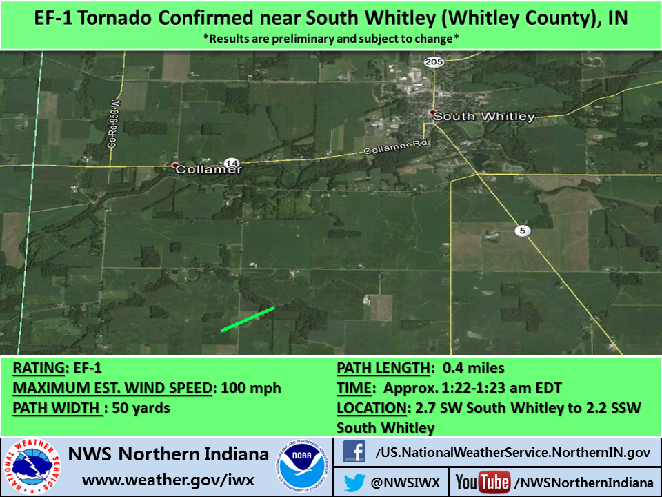
.TORNADO #6 - WHITLEY COUNTY...
RATING: EF-1
ESTIMATED PEAK WIND: 100 MPH
PATH LENGTH /STATUTE/: APPROX 0.4 MILES
MILES PATH WIDTH /MAXIMUM/: EST. 50 YARDS
FATALITIES: NONE
INJURIES: NONE
START DATE: JUL 01 2014
TIME: EST. 122 AM EDT
START LOCATION: 2.7 MI SW OF SOUTH WHITLEY, IN
START LAT/LON: 41.0516 / -85.6567
END DATE: JUL 01 2014
END TIME: EST. 123 AM EDT
END LOCATION: 2.2 MI SSW OF SOUTH WHITLEY, IN
END LAT/LON: 41.0551 / -85.6495
SURVEY SUMMARY: A BRIEF EF-1 TORNADO TOUCHED DOWN JUST WEST OF CR
850W IN A BEAN FIELD AND HIT A FARMSTEAD DESTROYING A BARN AND
CHICKEN COOP ALONG WITH EXTENSIVE TREE DAMAGE. MUCH OF THE DEBRIS
FROM THE BARN WAS LOFTED AND SCATTERED ACROSS THE ADJACENT FIELD TO
NORTHEAST AND EMBEDDED THROUGH THE TREELINE ONE QUARTER MILE
NORTHEAST. THIS IS ALSO WHERE A HORSE BARN LOST MOST OF ITS ROOF AND
A NEARBY HOME AND GARAGE SUSTAINED MINOR DAMAGE TO ROOFING AND
SIDING MATERIAL. HOWEVER SEVERE TREE DAMAGE OCCURRED THROUGH A LARGE
GROVE OF TREES JUST NORTH OF THIS LOCATION WITH SIGNIFICANT DEBRIS
LOADING NOTED IN THE TREES...MANY OF WHICH WERE SNAPPED AND/OR
UPROOTED.
.TORNADO #7 - KOSCIUSKO COUNTY...
RATING: EF-1
ESTIMATED PEAK WIND: 95 MPH
PATH LENGTH /STATUTE/: AROUND 0.6 MILE
MILES PATH WIDTH /MAXIMUM/: EST. 150 YARDS
FATALITIES: NONE
INJURIES: NONE
START DATE: JUL 01 2014
TIME: EST. 106 AM EDT
START LOCATION: 2 MI S OF GRAVELTON, IN
START LAT/LON: 41.1982 / -85.9226
END DATE: JUL 01 2014
END TIME: EST. 108 AM EDT
END LOCATION: 2 MI ENE OF PALESTINE, IN
END LAT/LON: 41.1915 / -85.9154
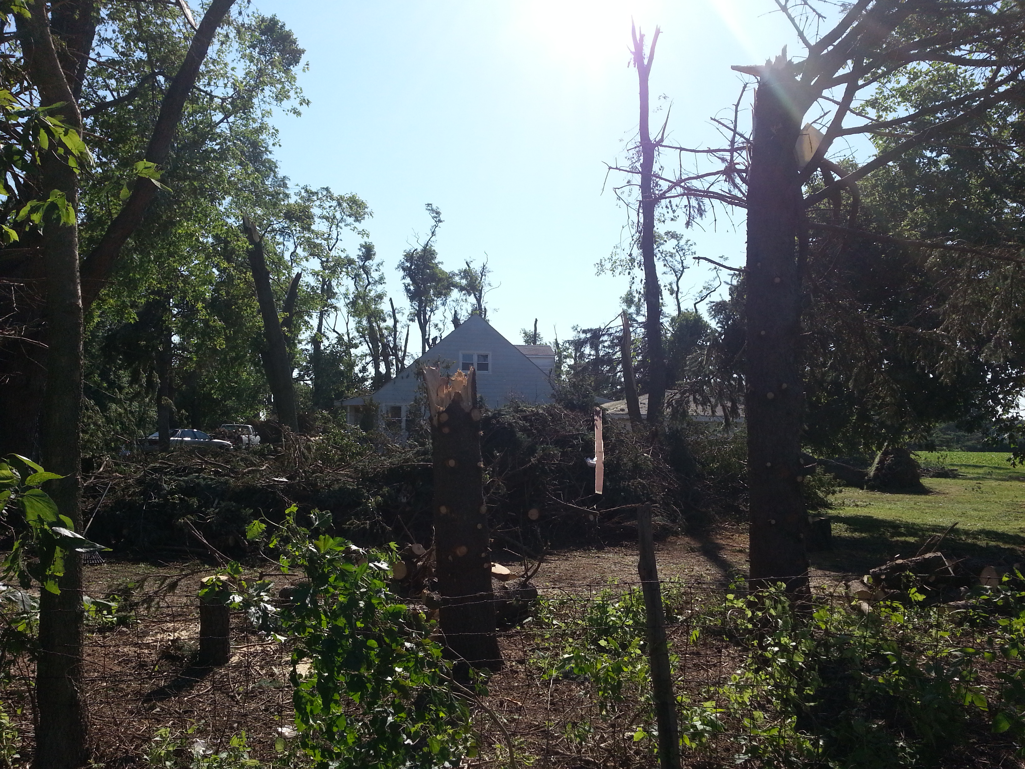
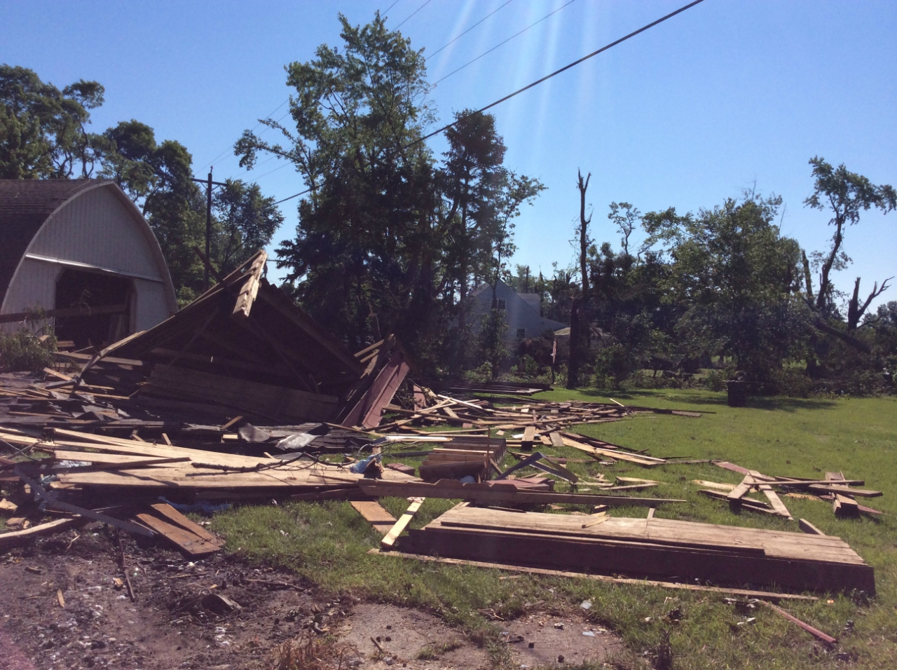
SURVEY SUMMARY: A BRIEF EF-1 TORNADO TOUCHED DOWN SOUTH OF GRAVELTON
NEAR A PROPERTY ON SOUTH COUNTY ROAD 400 WEST WHERE SEVERAL TREE
TRUNKS WERE SNAPPED AT THE TOPS OF THE TREES WITH 2 TREES UPROOTED.
A SMALL BARN SUFFERED EXTENSIVE ROOF DAMAGE AND PARTIAL WALL
FAILURE. THE TORNADO QUICKLY SHIFTED TOWARDS THE SOUTHEAST CROSSING
STATE ROUTE 25 WHERE IS BEGAN TO LIFT. PRIOR TO LIFTING...OVER 20
HEALTHY TREES WERE EITHER UPROOTED OR SNAPPED SEVERAL FEET IN THE
AIR. ONE OF THE UPROOTED TREES FELL ONTO A RESIDENCE.
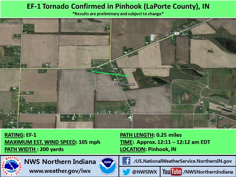
.TORNADO #8 - LAPORTE COUNTY...
RATING: EF-1
ESTIMATED PEAK WIND: 105 MPH
PATH LENGTH /STATUTE/: AROUND 0.25 MILE
MILES PATH WIDTH /MAXIMUM/: EST. 200 YARDS
FATALITIES: NONE
INJURIES: NONE
START DATE: JUL 01 2014
TIME: EST. 1211 AM EDT
START LOCATION: PINHOOK, IN
START LAT/LON: 41.5625 / -86.858
END DATE: JUL 01 2014
END TIME: EST. 1212 AM EDT
END LOCATION: PINHOOK, IN
END LAT/LON: 41.5617 / -86.853
SURVEY SUMMARY: A BRIEF EF1 TORNADO TOUCHED DOWN JUST SOUTH OF
HIGHWAY 2 NEAR THE TOWN OF PINHOOK AND LIFTED JUST EAST OF SOUTH
WOZNIAK ROAD. THE TORNADO CAUSED WIDESPREAD SEVERE TREE DAMAGE AND
DAMAGED MANY STRUCTURES INCLUDING A 2 STORY BARN WHICH WAS
DESTROYED.
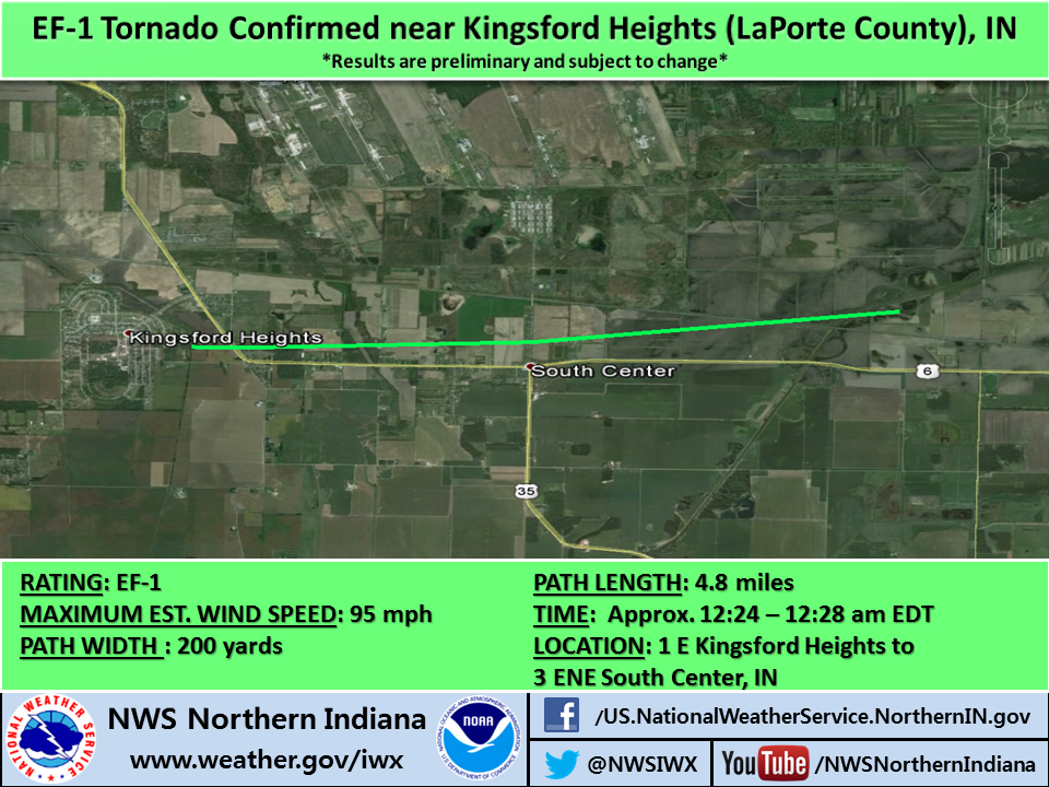
.TORNADO #9 - LAPORTE COUNTY...
RATING: EF-1
ESTIMATED PEAK WIND: 95 MPH
PATH LENGTH /STATUTE/: 4.8 MILES
MILES PATH WIDTH /MAXIMUM/: EST. 200 YARDS
FATALITIES: NONE
INJURIES: NONE
START DATE: JUL 01 2014
TIME: EST. 1224 AM EDT
START LOCATION: 1 EAST KINGSFORD HEIGHTS, IN
START LAT/LON: 41.4787 / -86.6837
END DATE: JUL 01 2014
END TIME: EST. 1228 AM EDT
END LOCATION: 3 ENE OF SOUTH CENTER, IN
END LAT/LON: 41.4849 / -86.5928
SURVEY SUMMARY: AN EF1 TORNADO TOUCHED DOWN JUST EAST OF KINGSFORD
HEIGHTS AND TRAVELED ENE TO JUST NORTH OF US 6 BEFORE DISSIPATING AS
IT CROSSED THE KANKAKEE RIVER. EXTENSIVE WIDESPREAD TREE DAMAGE
ALONG THE PATH OF THE TORNADO WAS NOTED. MANY HOMES IN THE PATH OF
THE TORNADO SUFFERED DAMAGE FROM FELLED TREES.
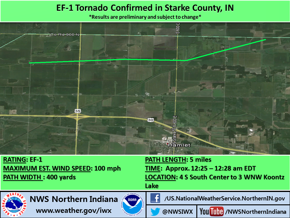
.TORNADO #10 - STARKE COUNTY...
RATING: EF-1
ESTIMATED PEAK WIND: 100 MPH
PATH LENGTH /STATUTE/: 5 MILES
MILES PATH WIDTH /MAXIMUM/: EST. 400 YARDS
FATALITIES: NONE
INJURIES: NONE
START DATE: JUL 01 2014
TIME: EST. 1225 AM EDT
START LOCATION: 4 S OF SOUTH CENTER, IN
START LAT/LON: 41.4189 / -86.6409
END DATE: JUL 01 2014
END TIME: EST. 1228 AM EDT
END LOCATION: 3 WNW OF KOONTZ LAKE, IN
END LAT/LON: 41.4317 / -86.5472
SURVEY SUMMARY: AN EF1 TORNADO TOUCHED DOWN NEAR THE INTERSECTION OF
N CR 300 E AND E CR 800 N. EXTENSIVE WIDESPREAD TREE DAMAGE ALONG
THE PATH OF THE TORNADO WAS NOTED. SEVERAL HOMES IN THE PATH OF THE
TORNADO SUSTAINED DAMAGE AS THE TORNADO MOVES EAST. A BARN WAS
DESTROYED NEAR CR 700 E AND ROBBINS ROAD. MULTIPLE CENTER PIVOTS
WERE FLIPPED IN CORN FIELDS.
.TORNADO #11 - STARKE/MARSHALL COUNTIES...
RATING: EF-1
ESTIMATED PEAK WIND: 110 MPH
PATH LENGTH /STATUTE/: 4.9 MILES
MILES PATH WIDTH /MAXIMUM/: EST. 400 YARDS
FATALITIES: NONE
INJURIES: NONE
START DATE: JUL 01 2014
TIME: EST. 1229 AM EDT
START LOCATION: 2 W OF KOONTZ LAKE, IN
START LAT/LON: 41.4187 / -86.5304
END DATE: JUL 01 2014
END TIME: EST. 1233 AM EDT
END LOCATION: 3 ENE OF KOONTZ LAKE, IN
END LAT/LON: 41.4384 / -86.4407
SURVEY SUMMARY: A STRONG EF-1 TORNADO TOUCHED DOWN JUST EAST OF CR
850 E AND JUST NORTH OF CR 800 N IN STARKE COUNTY. AS THE TORNADO
MOVED ENE IT CAUSED EXTENSIVE DAMAGE TO HARDWOOD TREES...ESPECIALLY
NORTH OF KOONTZ LAKE ALONG THE STARKE/MARSHALL COUNTY LINE. MINOR
STRUCTURAL DAMAGE WAS NOTED TO SEVERAL HOMES NEAR THE END OF THE
TORNADO. THE TORNADO LIFTED IN A GROVE OF TREES JUST EAST OF UNION
ROAD.
EF SCALE: THE ENHANCED FUJITA SCALE CLASSIFIES TORNADOES INTO THE
FOLLOWING CATEGORIES.
EF0...WEAK......65 TO 85 MPH
EF1...WEAK......86 TO 110 MPH
EF2...STRONG....111 TO 135 MPH
EF3...STRONG....136 TO 165 MPH
EF4...VIOLENT...166 TO 200 MPH
EF5...VIOLENT...>200 MPH
.ELKHART COUNTY SURVEY...
ABOUT 5 MILES SOUTHWEST OF GOSHEN...A SMALL SWATH OF TREE DAMAGE WAS
SURVEYED ALONG STATE ROAD 119 NEAR COUNTY ROAD 38. NUMEROUS PINE
TREES WERE SNAPPED OFF...ALONG WITH EXTENSIVE LIMB DAMAGE. THIS WAS
FOUND TO BE THE RESULT OF STRAIGHT LINE WINDS ESTIMATED AROUND 70
MPH.
JUST WEST OF U.S. 33 ADJACENT TO THE GOSHEN MUNICIPAL AIRPORT...A
LARGE OUTBUILDING HAD PART OF ITS ROOF REMOVED. AN EMPTY GRAIN BIN
WAS REMOVED FROM ITS FOUNDATION AND FLATTENED. A GRAIN SILO WAS
PARTIALLY SHIFTED OFF ITS FOUNDATION. A NUMBER OF LARGE TREE
BRANCHES WERE SNAPPED OFF AND THROWN EASTWARD...SOME ACROSS U.S. 33.
THIS WAS FOUND TO BE THE RESULT OF STRAIGHT LINE WINDS ESTIMATED
AROUND 80 MPH.
.KOSCIUSKO COUNTY SURVEY...
PARENT CIRCULATION ASSOCIATED WITH TORNADO #2 LED TO A MICROBURST
THAT HIT THE NORTHWEST SIDE OF SYRACUSE. DAMAGE OCCURRED TO THE
ATHLETIC COMPLEX AT WAWASEE HIGH SCHOOL AND POINTS NORTH INCLUDING
BOSTON AND BROOKLYN STREETS WHERE EXTENSIVE TREE DAMAGE OCCURRED
INCLUDING LIMBS AND TREES UPROOTED ONTO STRUCTURES. WIDESPREAD TREE
DAMAGE CONTINUED NORTHEASTWARD ALONG THE NORTH SHORE OF SYRACUSE
LAKE.
STRAIGHT LINE WIND DAMAGE WAS NOTED IN NUMEROUS CORN FIELDS ALONG
HIGHWAY 6 IN NORTHEAST KOSCIUSKO COUNTY WITH ESTIMATED WINDS AT 80
MPH.
.LAGRANGE COUNTY SURVEY...
IN ADDITION TO THE TORNADO IN LAGRANGE. AN EXTENSIVE MICROBURST WAS
NOTED ACROSS SOUTHERN LAGRANGE SOUTH OF U.S. 20 WITH WINDS OF 85 MPH
ESTIMATED. NUMEROUS LARGE TREES WHERE FELLED WITH MANY ROADS STILL
BLOCKED IN TOWN. IN ADDITION SEVERAL HOUSES SUSTAINED MINOR
STRUCTURAL DAMAGE. PARKVIEW ELEMENTARY SCHOOL LOST A SIGNIFICANT
PORTION OF AN EXTERIOR WALL.
ANOTHER SIGNIFICANT MICROBURST WAS SURVEYED BEGINNING ALONG THE
NORTHEAST SIDE OF BIG LONG LAKE WHERE NUMEROUS TREES WERE UPROOTED
AND FELL INTO HOMES. ONE FATALITY OCCURRED HERE WHERE A LARGE 8 FOOT
DIAMETER OAK TREE FELL INTO THE SIDE OF THE HOUSE. DAMAGE CONTINUED
NORTHEASTWARD TO THE TOWN OF STROH AND THE SOUTHWEST SIDE OF BIG
TURKEY LAKE. WIDESPREAD TREE DAMAGE WAS NOTED IN STROH ALONG WITH
MINOR STRUCTURAL DAMAGE.
.LAPORTE COUNTY SURVEY...
ABOUT 2 MILES NORTH OF KINGSBURY ON U.S. 35...AN OUTBUILDING WAS
DESTROYED. CORN WAS ALSO FLATTENED IN THIS AREA. THIS WAS FOUND TO
BE THE RESULT OF STRAIGHT LINE WINDS ESTIMATED AROUND 80 MPH.
AN EXTENSIVE SWATH OF DAMAGE WAS SURVEYED IN THE KINGSFORD HEIGHTS
AREA. TREES WERE UPROOTED AND SNAPPED THROUGHOUT KINGSFORD
HEIGHTS...RESULTING IN DAMAGE TO HOMES AND VEHICLES. WIDESPREAD TREE
LIMB DAMAGE WAS OBSERVED EASTWARD TO ABOUT 5 MILES EAST OF KINGSFORD
HEIGHTS ON U.S. 6. THIS WAS FOUND TO BE THE RESULT OF STRAIGHT LINE
WINDS ESTIMATED UP TO 85 MPH.
.MARSHALL COUNTY SURVEY...
IN ADDITION TO THE PLYMOUTH TORNADOES...AN INTENSE MICROBURST WAS
FOUND TO THE SOUTH OF THESE TORNADO PATHS WITH MAX WIND SPEEDS
ESTIMATED AT 80 TO 85 MPH. WIDESPREAD TREE DAMAGE WAS ASSOCIATED
WITH THIS ON THE NORTH SIDE OF PLYMOUTH JUST SOUTH OF US 30.
ADDITIONAL WIND DAMAGE WAS SURVEYED SOUTHEAST OF THE TOWN OF BREMEN
NEAR THE INTERSECTION OF 7TH ROAD AND STATE ROAD 331. NUMEROUS WHITE
PINE TREES WERE UPROOTED WITH SEVERAL COTTONWOOD TREES SNAPPED. A
HOUSE ALSO SUSTAINED SIDING DAMAGE. JUST TO THE NORTHEAST OF THIS
LOCATION A 250 YARD SWATH OF CORN WAS FLATTENED.
ADDITIONAL INTENSE WIND DAMAGE WAS SURVEYED IN THE TOWN OF
TIPPECANOE AND ESPECIALLY ALONG 18B ROAD. SEVERAL STRUCTURES
SUSTAINED MINOR TO MODERATE DAMAGE WITH EXTENSIVE TREE DAMAGE IN
SPOTS. THE MICROBURST WIND DAMAGE PATH EXTENDED FOR APPROXIMATELY 2
MILES. WINDS HERE WERE ESTIMATED AT 80 TO 85 MPH.
.ST. JOSEPH COUNTY INDIANA SURVEY...
A SWATH OF DAMAGE WAS SURVEYED ALONG JEFFERSON BOULEVARD FROM THE
ST. JOSEPH RIVER EASTWARD TO JUST SOUTH OF BETHEL COLLEGE. MANY
TREES WERE UPROOTED ALONG THIS PATH. THIS WAS FOUND TO BE THE RESULT
OF STRAIGHT LINE WINDS ESTIMATED UP TO 80 MPH.
NOTE:
THE INFORMATION IN THIS STATEMENT IS PRELIMINARY AND SUBJECT TO
CHANGE PENDING FINAL REVIEW OF THE EVENT AND PUBLICATION IN
NWS STORM DATA. ADDITIONAL SURVEYS MAY BE CONDUCTED AS ADDITIONAL
INFORMATION BECOMES AVAILABLE.
$$
TH/NG/CEO/LF
| LaPorte County Tornado |
Path Map |
Description |
RATING: EF-1
MAX WIND SPEED: 105 mph
PATH WIDTH :
200 yards
PATH LENGTH:
0.25 miles
TIME: Approx. 12:11-12:12 am EDT
LOCATION: Pinhook
|
 |
A BRIEF EF1 TORNADO TOUCHED DOWN JUST SOUTH OF HIGHWAY 2 NEAR THE TOWN OF PINHOOK AND LIFTED JUST EAST OF SOUTH WOZNIAK ROAD. THE TORNADO CAUSED WIDESPREAD SEVERE TREE DAMAGE AND DAMAGED MANY STRUCTURES INCLUDING A 2 STORY BARN WHICH WAS DESTROYED. |
| LaPorte County Tornado |
Path Map |
Description |
RATING: EF-1
MAX WIND SPEED: 95 mph
PATH WIDTH :
200 yards
PATH LENGTH:
4.8 miles
TIME: Approx. 12:24-12:28 am EDT
LOCATION: 1 E Kingsford Heights to 3 ENE South Center
|
 |
AN EF1 TORNADO TOUCHED DOWN JUST EAST OF KINGSFORD HEIGHTS AND TRAVELED ENE TO JUST NORTH OF US 6 BEFORE DISSIPATING AS IT CROSSED THE KANKAKEE RIVER. EXTENSIVE WIDESPREAD TREE DAMAGE ALONG THE PATH OF THE TORNADO WAS NOTED. MANY HOMES IN THE PATH OF THE TORNADO SUFFERED DAMAGE FROM FELLED TREES. |
| Starke County Tornado |
Path Map |
Description |
RATING: EF-1
MAX WIND SPEED: 100 mph
PATH WIDTH :
400 yards
PATH LENGTH:
5 miles
TIME: Approx. 12:25-12:28 am EDT
LOCATION: 4 S South Center to 3 WNW Koontz Lake
|
 |
AN EF1 TORNADO TOUCHED DOWN NEAR THE INTERSECTION OF N CR 300 E AND E CR 800 N. EXTENSIVE WIDESPREAD TREE DAMAGE ALONG THE PATH OF THE TORNADO WAS NOTED. SEVERAL HOMES IN THE PATH OF THE TORNADO SUSTAINED DAMAGE AS THE TORNADO MOVED EAST. A BARN WAS DESTROYED NEAR CR 700 E AND ROBBINS ROAD. MULTIPLE CENTER PIVOTS WERE FLIPPED IN CORN FIELDS. |
| Starke/Marshall County Tornado |
Path Map |
Description |
RATING: EF-1
MAX WIND SPEED: 110 mph
PATH WIDTH :
400 yards
PATH LENGTH:
4.9 miles
TIME: Approx. 12:29-12:33 am EDT
LOCATION: 2 W of Koontz Lake to 3 ENE Koontz Lake
|
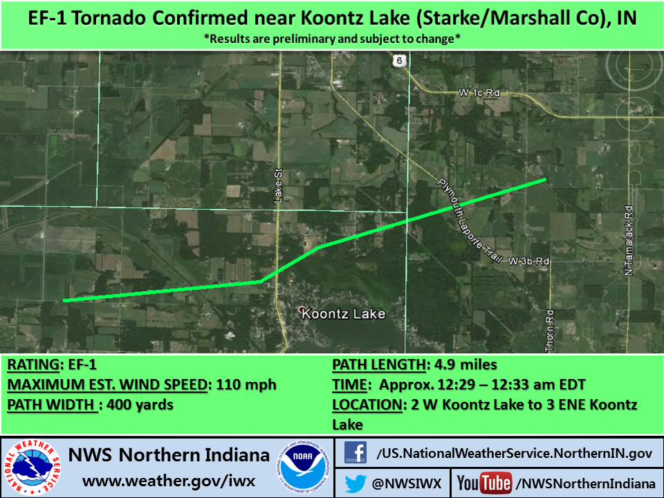 |
A STRONG EF-1 TORNADO TOUCHED DOWN JUST EAST OF CR 850 E AND JUST NORTH OF CR 800 N IN STARKE COUNTY. AS THE TORNADO MOVED ENE IT CAUSED EXTENSIVE DAMAGE TO HARDWOOD TREES...ESPECIALLY NORTH OF KOONTZ LAKE ALONG THE STARKE/MARSHALL COUNTY LINE WITH A 250 YARD SWATH OF INTENSE TREE DAMAGE NOTED IN A HEAVILY FORESTED AREA ALONG PINE RIDGE RD. MINOR STRUCTURAL DAMAGE WAS NOTED TO SEVERAL HOMES NEAR THE END OF THE TORNADO IN NORTHWEST MARSHALL COUNTY. THE TORNADO LIFTED IN A GROVE OF TREES JUST EAST OF UNION ROAD. |
| Marshall County Tornado |
Path Map |
Description |
RATING: EF-1
MAX WIND SPEED: 105 mph
PATH WIDTH :
150 yards
PATH LENGTH:
Approx. 7 miles
TIME: Approx. 12:35-12:42 am EDT
LOCATION: 1 mi S of Donaldson to 1 mi N of Plymouth
|
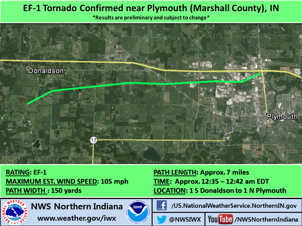 |
AN EF-1 TORNADO TOUCHED DOWN JUST SOUTH OF DONALDSON WHERE IT CAUSED EXTENSIVE DAMAGE TO HARDWOOD TREES. THE TORNADO MOVED EAST AND HEAVILY DAMAGED A FARM ON SYCAMORE ROAD JUST SOUTH OF THE RAILROAD TRACKS. EXTENSIVE TREE DAMAGE CONTINUED TO THE EAST/NORTHEAST INTO THE TOWN OF PLYMOUTH TO THE LEAR CORPORATION WHERE MULTIPLE TREES WERE SNAPPED AND TOPPED. AN EMPTY SEMI TRAILER WAS FLIPPED. THE TORNADO CONTINUED NE WITH WIDESPREAD MIXED HARDWOOD/SOFTWOOD TREE DAMAGE AND MINOR STRUCTURAL DAMAGE TO THE BEHAVIOR SCIENCE BUILDING ON N OAK ROAD. THE TORNADO CAUSED PARTIAL UPLIFT OF THE NW SIDE OF THE ROOF AND COLLAPSED THE INTERIOR CINDER BLOCK WALL ON THE EAST SIDE OF THE DEPT OF TRANSPORTATION GARAGE JUST SOUTH OF US 30 BEFORE LIFTING. |
| Marshall County Tornado |
Path Map |
Description |
RATING: EF-1
MAX WIND SPEED: 95 mph
PATH WIDTH :
50 yards
PATH LENGTH:
0.2 miles
TIME: Approx. 12:41-12:42 am EDT
LOCATION: 2 mi NE of Plymouth to 2.2 mi NE of Plymouth
|
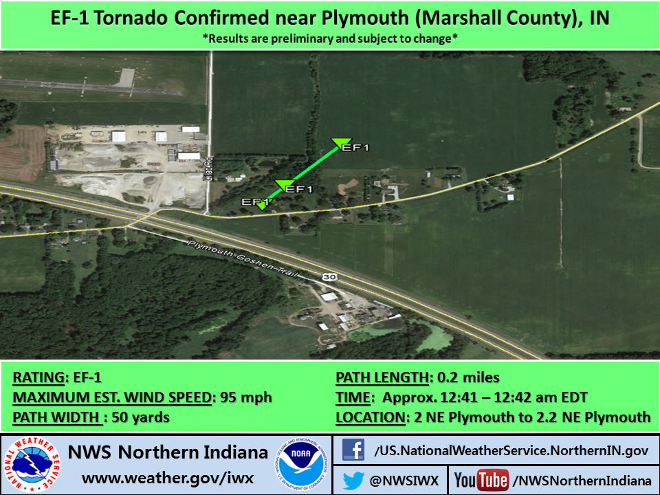 |
A BRIEF EF-1 TORNADO TOUCHED DOWN NEAR THE INTERSECTION OF LILAC ROAD AND PLYMOUTH GOSHEN TRAIL JUST NE OF
PLYMOUTH AROUND 1241 AM EDT. WIDESPREAD HARDWOOD TREE DAMAGE WAS NOTED IN THIS LOCATION WITH SEVERAL UPROOTED AND SNAPPED TREES AND A SHED WAS FLATTENED. AS THE CIRCULATION MOVED NE IT SHIFTED A BARN OFF ITS FOUNDATION AND CAUSED WIDESPREAD SEVERE TREE DAMAGE IN A GROVE OF TREES BEFORE LIFTING IN A FIELD ON THE OTHER SIDE OF THE TREE GROVE. |
| Kosciusko County Tornado |
Path Map |
Description |
RATING: EF-1
MAX WIND SPEED: 95 mph
PATH WIDTH :
150 yards
PATH LENGTH:
0.6 miles
TIME: Approx. 1:06-1:08 am EDT
LOCATION: 2 mi S of Gravelton, IN to 2 mi ENE of Palestine, IN
|
 |
A BRIEF EF-1 TORNADO TOUCHED DOWN NEAR A PROPERTY ON SOUTH COUNTY ROAD 400 WEST WHERE SEVERAL TREE TRUNKS WERE SNAPPED AT THE TOPS OF THE TREES WITH 2 TREES UPROOTED. A SMALL BARN SUFFERED EXTENSIVE ROOF DAMAGE AND PARTIAL WALL
FAILURE. THE TORNADO QUICKLY SHIFTED TOWARDS THE SOUTHEAST CROSSING
STATE ROUTE 25 WHERE IS BEGAN TO LIFT. PRIOR TO LIFTING...OVER 20 HEALTHY TREES WERE EITHER UPROOTED OR SNAPPED SEVERAL FEET IN THE AIR. ONE OF THE UPROOTED TREES FELL ONTO A RESIDENCE. |
| Kosciusko County Tornado |
Path Map |
Description |
RATING: EF-0
MAX WIND SPEED: 80 mph
PATH WIDTH :
50 yards
PATH LENGTH:
1.9 miles
TIME: Approx. 1:06-1:08 am EDT
LOCATION: 3.5 mi W to 2.2 mi WNW of Milford
|
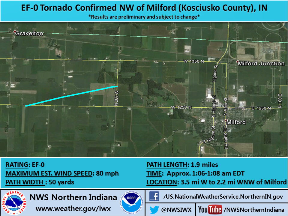 |
A TORNADO TOUCHED DOWN JUST SOUTH OF CR 1250N AND EAST OF CR 400W AROUND 106 AM EDT...WHERE A LARGE METAL FARM BUILDING WAS DESTROYED. TORNADO CROSSED CR 1250N AND WENT THROUGH A CORN FIELD AND THEN DESTROYED A BARN NEAR 200W NORTH OF CR 1250N WITH MISSILE DEBRIS SCATTERED TO THE EAST ACROSS 200W AND INTO ANOTHER CORN FIELD WHERE THE CIRCULATION LIFTED AND OR DISSIPATED. |
| Wabash/Kosciusko County Tornado |
Path Map |
Description |
RATING: EF-1
MAX WIND SPEED: 100 mph
PATH WIDTH :
150 yards
PATH LENGTH:
Approx. 7 miles
TIME: Approx. 1:08-1:15 am EDT
LOCATION: 2.8 miles SSW of Silver Lake, IN to 6.9 miles ESE of Silver Lake, IN
|
 |
AN EF-1 TORNADO TOUCHED DOWN JUST WEST OF SR 15 IN A CORN FIELD IN NORTHWEST WABASH COUNTY WITH GROUND SCOURING NOTED. THIS TORNADO PROCEEDED EAST NORTHEAST WITH EXTENSIVE TREE AND CROP DAMAGE. SEVERAL FARMSTEADS ALONG THE PATH SUSTAINED MINOR TO MODERATE DAMAGE. ONE FARM JUST NORTH OF THE COUNTY LINE ROAD IN KOSCIUSKO COUNTY HAD A HOG BARN DESTROYED WITH MUCH OF THE DEBRIS THROWN SOUTHEASTWARD INTO A LARGE GRAIN SILO FACILITY WITH ONE LARGE GRAIN BIN COMPLETELY FLATTENED AND SEVERE DAMAGE TO A HARVESTER SILO. IN ADDITION A CORN CROP FIELD TO THE SOUTH OF THE COUNTY LINE ROAD AND JUST EAST OF THE FARM WAS FLATTENED AND SHREDDED. ADDITIONAL EXTENSIVE TREE AND CROP DAMAGE CONTINUED BEFORE THE TORNADO DISSIPATED IN A GROVE OF TREES JUST WEST OF CR 400E. |
| Whitley County Tornado |
Path Map |
Description |
RATING: EF-1
MAX WIND SPEED: 100 mph
PATH WIDTH :
50 yards
PATH LENGTH:
Approx. 0.4 miles
TIME: Approx. 1:22-1:23 am EDT
LOCATION: 2.7 miles SW of South Whitley, IN to 2.2 miles SSW of South Whitley, IN
|
 |
A BRIEF EF-1 TORNADO TOUCHED DOWN JUST WEST OF CR 850W IN A BEAN FIELD AND HIT A FARMSTEAD DESTROYING A BARN AND
CHICKEN COOP ALONG WITH EXTENSIVE TREE DAMAGE. MUCH OF THE DEBRIS FROM THE BARN WAS LOFTED AND SCATTERED ACROSS THE ADJACENT FIELD TO NORTHEAST AND EMBEDDED THROUGH THE TREELINE ONE QUARTER MILE NORTHEAST. THIS IS ALSO WHERE A HORSE BARN LOST MOST OF ITS ROOF AND A NEARBY HOME AND GARAGE SUSTAINED MINOR DAMAGE TO ROOFING AND
SIDING MATERIAL. HOWEVER SEVERE TREE DAMAGE OCCURRED THROUGH A LARGE
GROVE OF TREES JUST NORTH OF THIS LOCATION WITH SIGNIFICANT DEBRIS
LOADING NOTED IN THE TREES...MANY OF WHICH WERE SNAPPED AND/OR UPROOTED. |
| LaGrange Tornado |
Path Map |
Description |
RATING: EF-1
MAX WIND SPEED: 95 mph
PATH WIDTH :
50 yards
PATH LENGTH:
Approx 1 mile
TIME: Approx. 1:38-1:40 am EDT
LOCATION: 1 mile W of LaGrange to LaGrange
|
 |
A TORNADO TOUCHED DOWN JUST WEST OF LAGRANGE ON U.S. 20 AROUND 130 AM EDT...WHERE TREE LIMB DAMAGE WAS OBSERVED. THE TORNADO TRACKED EAST TOWARD LAGRANGE...UPROOTING AND SNAPPING TREES AS IT ENTERED THE TOWN SOUTH OF THE HOSPITAL. NUMEROUS TREES WERE UPROOTED AND SNAPPED JUST WEST OF S COUNTY ROAD 00 E BETWEEN U.S. 20 AND GRANT STREET. THE TORNADO PRODUCED MINOR STRUCTURAL DAMAGE TO HOMES ALONG GRANT STREET BEFORE LIFTING JUST WEST OF S MOUNTAIN STREET. THIS TORNADO WAS EMBEDDED ALONG THE NORTH FLANK OF A MUCH LARGER ONE MILE WIDE SWATH OF INTENSE DAMAGING WINDS OF 70-80 MPH ALONG AND SOUTH OF HIGHWAY 20 IN LAGRANGE. ESTIMATED WINDS WITH THE TORNADO WERE 95 MPH. |
| Straight-Line Wind Damage Surveys |
|
ELKHART COUNTY SURVEY
ABOUT 5 MILES SOUTHWEST OF GOSHEN...A SMALL SWATH OF TREE DAMAGE WAS SURVEYED ALONG STATE ROAD 119 NEAR COUNTY ROAD 38. NUMEROUS PINE TREES WERE SNAPPED OFF...ALONG WITH EXTENSIVE LIMB DAMAGE. THIS WAS FOUND TO BE THE RESULT OF STRAIGHT LINE WINDS ESTIMATED AROUND 70 MPH.
JUST WEST OF U.S. 33 ADJACENT TO THE GOSHEN MUNICIPAL AIRPORT...A LARGE OUTBUILDING HAD PART OF ITS ROOF REMOVED. AN EMPTY GRAIN BIN WAS REMOVED FROM ITS FOUNDATION AND FLATTENED. A GRAIN SILO WAS PARTIALLY SHIFTED OFF ITS FOUNDATION. A NUMBER OF LARGE TREE BRANCHES WERE SNAPPED OFF AND THROWN EASTWARD...SOME ACROSS U.S. 33. THIS WAS FOUND TO BE THE RESULT OF STRAIGHT LINE WINDS ESTIMATED AROUND 80 MPH.
KOSCIUSKO COUNTY SURVEY
PARENT CIRCULATION ASSOCIATED WITH TORNADO #2 LED TO A MICROBURST THAT HIT THE NORTHWEST SIDE OF SYRACUSE. DAMAGE OCCURRED TO THE ATHLETIC COMPLEX AT WAWASEE HIGH SCHOOL AND POINTS NORTH INCLUDING BOSTON AND BROOKLYN STREETS WHERE EXTENSIVE TREE DAMAGE OCCURRED INCLUDING LIMBS AND TREES UPROOTED ONTO STRUCTURES. WIDESPREAD TREE DAMAGE CONTINUED NORTHEASTWARD ALONG THE NORTH SHORE OF SYRACUSE LAKE.
STRAIGHT LINE WIND DAMAGE WAS NOTED IN NUMEROUS CORN FIELDS ALONG HIGHWAY 6 IN NORTHEAST KOSCIUSKO COUNTY WITH ESTIMATED WINDS AT 80 MPH.
LAGRANGE COUNTY SURVEY
IN ADDITION TO THE TORNADO IN LAGRANGE. AN EXTENSIVE MICROBURST WAS NOTED ACROSS SOUTHERN LAGRANGE SOUTH OF U.S. 20 WITH WINDS OF 85 MPH ESTIMATED. NUMEROUS LARGE TREES WHERE FELLED WITH MANY ROADS STILL
BLOCKED IN TOWN. IN ADDITION SEVERAL HOUSES SUSTAINED MINOR STRUCTURAL DAMAGE. PARKVIEW ELEMENTARY SCHOOL LOST A SIGNIFICANT PORTION OF AN EXTERIOR WALL.
ANOTHER SIGNIFICANT MICROBURST WAS SURVEYED BEGINNING ALONG THE NORTHEAST SIDE OF BIG LONG LAKE WHERE NUMEROUS TREES WERE UPROOTED AND FELL INTO HOMES. ONE FATALITY OCCURRED HERE WHERE A LARGE 6 FOOT
DIAMETER OAK TREE FELL INTO THE SIDE OF THE HOUSE. DAMAGE CONTINUED NORTHEASTWARD TO THE TOWN OF STROH AND THE SOUTHWEST SIDE OF BIG TURKEY LAKE. WIDESPREAD TREE DAMAGE WAS NOTED IN STROH ALONG WITH MINOR STRUCTURAL DAMAGE.
LAPORTE COUNTY SURVEY
ABOUT 2 MILES NORTH OF KINGSBURY ON U.S. 35...AN OUTBUILDING WAS DESTROYED. CORN WAS ALSO FLATTENED IN THIS AREA. THIS WAS FOUND TO BE THE RESULT OF STRAIGHT LINE WINDS ESTIMATED AROUND 80 MPH.
AN EXTENSIVE SWATH OF DAMAGE WAS SURVEYED IN THE KINGSFORD HEIGHTS AREA. TREES WERE UPROOTED AND SNAPPED THROUGHOUT KINGSFORD HEIGHTS...RESULTING IN DAMAGE TO HOMES AND VEHICLES. WIDESPREAD TREE
LIMB DAMAGE WAS OBSERVED EASTWARD TO ABOUT 5 MILES EAST OF KINGSFORD HEIGHTS ON U.S. 6. THIS WAS FOUND TO BE THE RESULT OF STRAIGHT LINE WINDS ESTIMATED UP TO 85 MPH.
MARSHALL COUNTY SURVEY
IN ADDITION TO THE PLYMOUTH TORNADOES...AN INTENSE MICROBURST WAS FOUND TO THE SOUTH OF THESE TORNADO PATHS WITH MAX WIND SPEEDS ESTIMATED AT 80 TO 85 MPH. WIDESPREAD TREE DAMAGE WAS ASSOCIATED WITH THIS ON THE NORTH SIDE OF PLYMOUTH JUST SOUTH OF US 30.
ADDITIONAL WIND DAMAGE WAS SURVEYED SOUTHEAST OF THE TOWN OF BREMEN NEAR THE INTERSECTION OF 7TH ROAD AND STATE ROAD 331. NUMEROUS WHITE PINE TREES WERE UPROOTED WITH SEVERAL COTTONWOOD TREES SNAPPED. A
HOUSE ALSO SUSTAINED SIDING DAMAGE. JUST TO THE NORTHEAST OF THIS LOCATION A 250 YARD SWATH OF CORN WAS FLATTENED.
ADDITIONAL INTENSE WIND DAMAGE WAS SURVEYED IN THE TOWN OF TIPPECANOE AND ESPECIALLY ALONG 18B ROAD. SEVERAL STRUCTURES SUSTAINED MINOR TO MODERATE DAMAGE WITH EXTENSIVE TREE DAMAGE IN SPOTS.
THE MICROBURST WIND DAMAGE PATH EXTENDED FOR APPROXIMATELY 2 MILES. WINDS HERE WERE ESTIMATED AT 80 TO 85 MPH.
ST. JOSEPH COUNTY INDIANA SURVEY
A SWATH OF DAMAGE WAS SURVEYED ALONG JEFFERSON BOULEVARD FROM THE ST. JOSEPH RIVER EASTWARD TO JUST SOUTH OF BETHEL COLLEGE. MANY TREES WERE UPROOTED ALONG THIS PATH. THIS WAS FOUND TO BE THE RESULT OF STRAIGHT LINE WINDS ESTIMATED UP TO 80 MPH.
|
A strong low pressure system was moving across the region during June 30th - July 1st. The local area was situated to the west of a cold front in what we call the "warm sector," an area with very moist and unstable air due to southerly winds. There were essentially 2 lines of severe storms that affected the western Great Lakes region on June 30th into the early morning hours of July 1st. Severe thunderstorms fired across eastern Nebraska on the afternoon of the 30th and quickly grew in size and strength as they formed a line and moved eastward into Iowa and eventually northern Illinois. Widespread wind damage was observed with this line of storms, especially across northern Illinois. This line eventually ran out of steam and dissipated as it moved into northwest Indiana. Some sporadic tree damage and hail reports were received over Berrien, LaPorte, and St. Joseph (IN) counties. These storms left an outflow boundary as they dissipated that stalled west to east along a line from Winamac to Warsaw. This boundary would help to feed the second line of storms later.
As this first line was decaying, a second round of severe thunderstorms rapidly fired, expanded, and intensified back west through eastern Iowa and northern Illinois. The enviroment was still very favorable for severe weather across this region which allowed for these storms to quickly congeal into a line and move to the east, approaching the local area. Unstable air and substantial wind shear allowed for these storms to progress into northern Indiana and southern Michigan during the overnight hours from June 30th into July 1st. Widespread wind damage occurred across most of the area along the leading edge of the line of storms. Weak to moderate circulations on the leading edge of the storm also produced several weak tornadoes in northern Indiana. These storms became wind dominant across eastern Indiana and eventually weakened across portions of western Ohio.
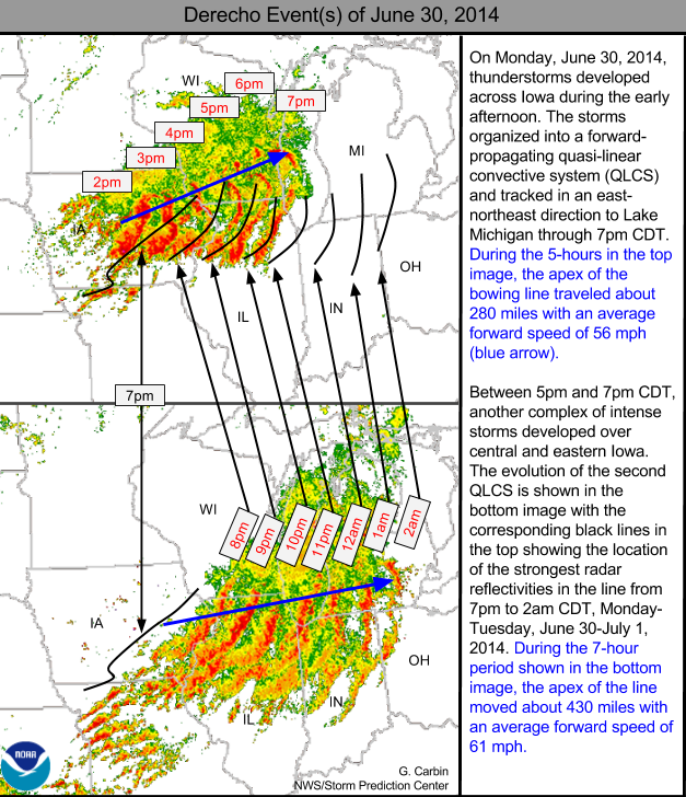
To sustain themselves and become severe, thunderstorms need heat and moisture (which creates instability), wind shear (strong winds that change direction with height), and forcing (such as a cold front). Environments necessary for thundstorms are typically found in the Midwest from late spring through summer. For this particular event, there was enough instability and strong wind shear present ahead of a cold front to produce thunderstorms that quickly became severe. In this case, the line of severe storms was in the form of what meteorologists call a quasi-linear convective system or QLCS. The system lasted long enough to be deemed a "derecho" by the Storm Prediction Center. The image below is courtesy of the Storm Prediction Center.
The images and descriptions below give a depiction of the mesoscale atmospheric conditions present at 11 pm EDT (03Z) on Monday, June 30th just before the line of storms moved into the area.
 |
 |
 |
| Surface analysis (3Z) shows a cold front to the west near the IA/IL border. Surface dew points ahead of the front were in the 70s providing moisture to fuel the thunderstorms. |
850 mb analysis shows a low-level jet (~25-45 kts) pumping warm, moist air into the area ahead of a low pressure center. This helped to fuel and sustain thunderstorms as they developed in northern IL and moved into the local area. |
500 mb analysis shows a mid-level trough of low pressure, just to the west of the local area. This, coupled with a mid-level jet stream rounding the base of the trough, provided forcing for the thunderstorms to fire to the west before moving into the local area. |
 |
 |
 |
| Effective Bulk Shear: A measure of the difference between winds at the surface and aloft in the atmosphere. Supercells and/or tornadoes become more probably as the effect bulk shear vector increases in magnitude through the range of 25-40 kt and greater. Values across the local area were in the 30-50 kt range. |
0 - 1 KM Storm Relative Helicity (SRH): SRH is a measure of the potential for rotating storm cells. Values of 0-1km SRH greater than 100 m2/s2 suggest increased threat of tornadoes. Values across the local area were in the 150-300 m2/s2 range with storm motion of 30-35 kts. |
Radar Composite (3Z) : This shows the line of storms at 11 pm EDT in relation to the local area. |
| Storm Prediction Center Day 1 Outlook Issued 6/30/14 |
 |
|
Storm Prediction Center Day 2 Outlook
Issued 6/29/14
|
Storm Prediction Center Day 3 Outlook
Issued 6/28/14
|
 |
 |
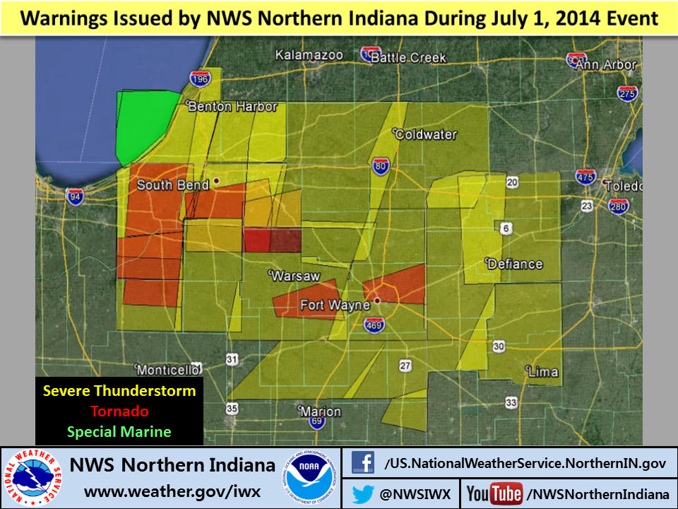
The NWS Northern Indiana issued 7 tornado warnings and countless severe thunderstorm warnings as the line of storms moved across the area into NW Ohio. The severe thunderstorm warnings indicated the likelihood of 70-80 mph winds and used the "Tornado Possible" tag at the bottom of the warnings. Below is a portion of a severe thunderstorm warning issue during the event with pertinent parts highlighted in red.
BULLETIN - EAS ACTIVATION REQUESTED
SEVERE THUNDERSTORM WARNING
NATIONAL WEATHER SERVICE NORTHERN INDIANA
100 AM EDT TUE JUL 1 2014
THE NATIONAL WEATHER SERVICE IN NORTHERN INDIANA HAS ISSUED A
* SEVERE THUNDERSTORM WARNING FOR...
NORTHWESTERN DE KALB COUNTY IN NORTHEAST INDIANA...
ELKHART COUNTY IN NORTH CENTRAL INDIANA...
LAGRANGE COUNTY IN NORTHEAST INDIANA...
NORTHERN NOBLE COUNTY IN NORTHEAST INDIANA...
WESTERN STEUBEN COUNTY IN NORTHEAST INDIANA...
BRANCH COUNTY IN SOUTHWEST MICHIGAN...
EASTERN CASS COUNTY IN SOUTHWEST MICHIGAN...
ST. JOSEPH COUNTY IN SOUTHWEST MICHIGAN...
* UNTIL 145 AM EDT
* AT 1256 AM EDT...SEVERE THUNDERSTORMS WERE LOCATED ALONG A LINE
EXTENDING FROM 11 MILES NORTH OF PAW PAW TO CASSOPOLIS TO
WAKARUSA...AND MOVING EAST AT 65 MPH.
THESE ARE VERY DANGEROUS STORMS.
HAZARD...80 MPH WIND GUSTS.
SOURCE...EMERGENCY MANAGEMENT. WIDESPREAD REPORTS OF WIND DAMAGE IN
SOUTH BEND.
IMPACT...MOBILE HOMES WILL BE HEAVILY DAMAGED. FLYING DEBRIS WILL BE
DANGEROUS TO PEOPLE AND ANIMALS. EXPECT CONSIDERABLE DAMAGE TO ROOFS...
WINDOWS AND VEHICLES. EXTENSIVE TREE DAMAGE AND POWER OUTAGES ARE
LIKELY.
PRECAUTIONARY/PREPAREDNESS ACTIONS...
THIS IS AN EXTREMELY DANGEROUS SITUATION WITH TORNADO LIKE WIND
SPEEDS EXPECTED. MOBILE HOMES AND HIGH PROFILE VEHICLES ARE
ESPECIALLY SUSCEPTIBLE TO WINDS OF THIS MAGNITUDE AND MAY BE
OVERTURNED. FOR YOUR PROTECTION MOVE TO AN INTERIOR ROOM ON THE
LOWEST FLOOR OF A BUILDING. THESE STORMS HAVE THE POTENTIAL TO CAUSE
SERIOUS INJURY AND SIGNIFICANT PROPERTY DAMAGE.
TORNADO...POSSIBLE
HAIL...<.75IN
WIND...80MPH
|
The graphic below shows all warnings that were issued during the event.
 |
 |
 |
 |
| Near Milford |
Near Palestine |
Big Long Lake - Fatality |
Near Angola |
 |
 |
 |
 |
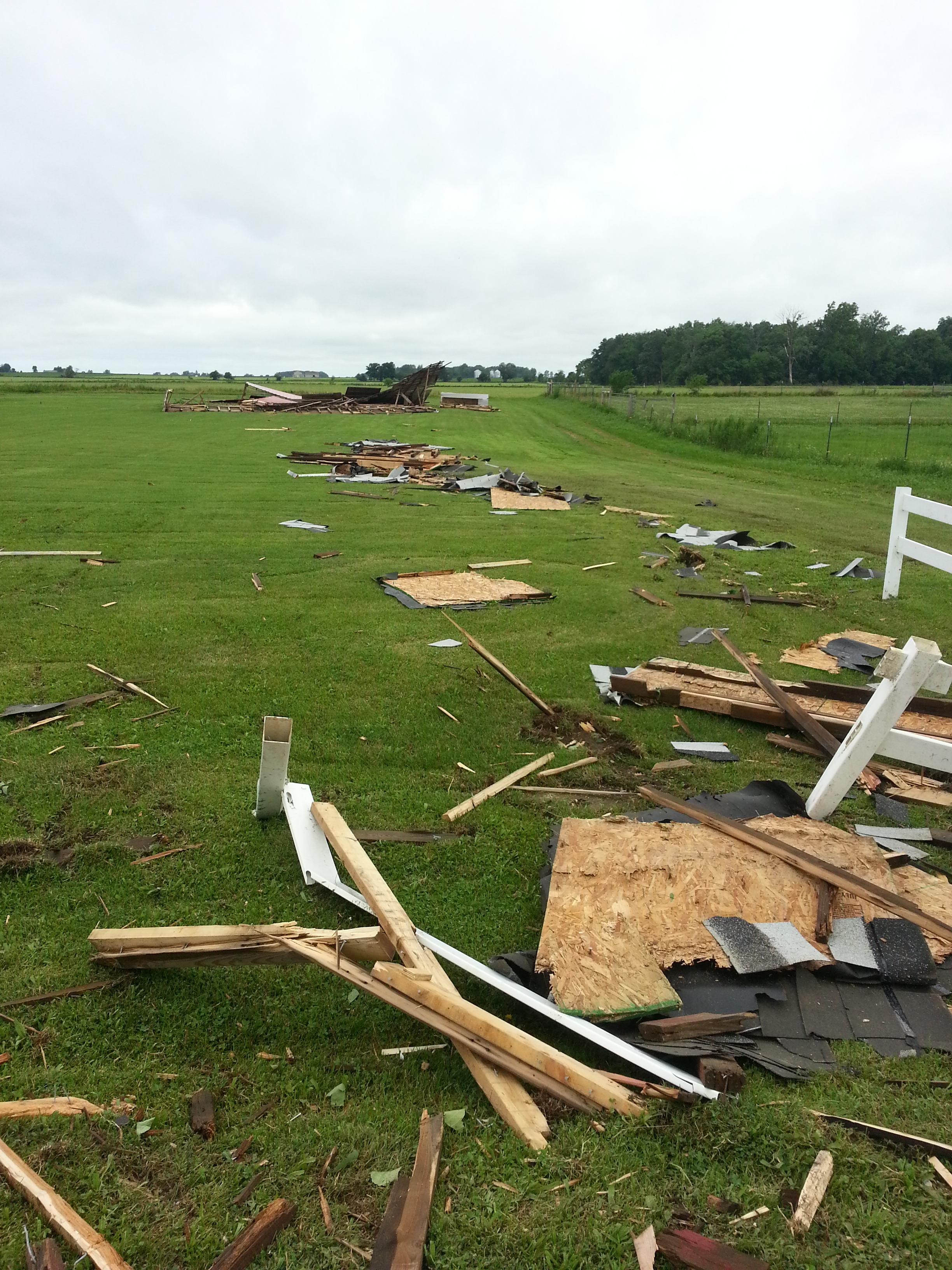
| Near Pinhook |
Near Pinhook |
Near Plymouth |
Near South Whitley |
Updated 7/5/2014 11:15 AM EDT
CEO/NG/TH/LWF

