Overview
Severe storms brought tornadoes, straight line winds, and heavy rain/flooding to the forecast area. Did you have damage from the July 10th storms? Submit your report here. Our office has completed the damage survey, and the results on the tornadoes are located in the tornado section. You can also check out the damage information statement here.
Tornadoes:
Final PNS giving details of the Tornado Tracks/Rankings
|
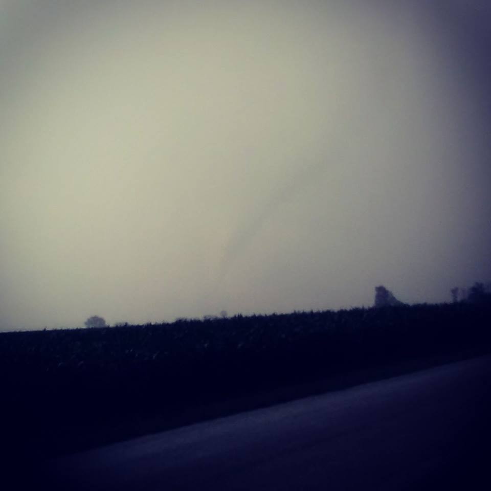
Tornado - 7.7 S Logansport, IN
Track Map 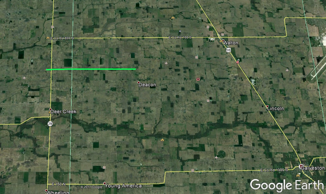 
Downloadable KMZ File |
||||||||||||||||
|
Tornado - 4.1 NE Denver, IN
Track Map 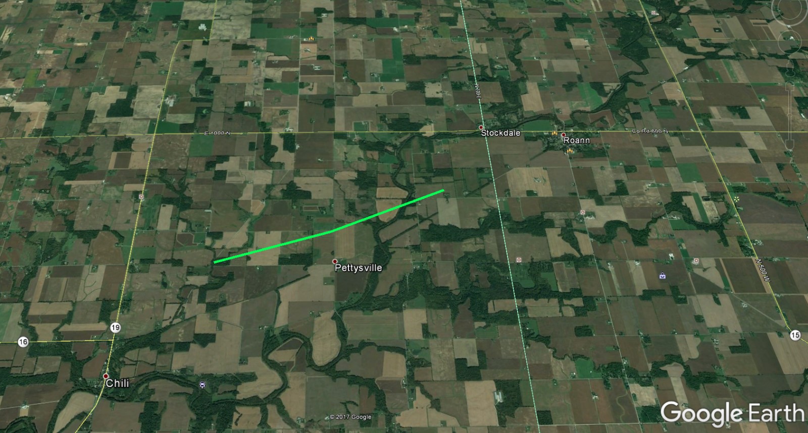
Downloadable KMZ File |
||||||||||||||||
|
Radar Data for the Wabash, IN Storm (No Damage Found in Survey)  |
||
Wind & Hail:
Wind
We only received two reports of straight line wind damage, with no photos received as of yet. Both of the reports were from Adams County, IN. If you had straight line wind damage, send us a report! Email us your pictures at w-iwx.webmaster@noaa.gov, and we'll include them in our web story.
Straight Line Wind Reports Received
0755 PM     TSTM WND DMG     1 W DECATUR             40.83N 84.94W
07/10/2017                   ADAMS              IN   PUBLIC

            TREES DOWN.


0800 PM     TSTM WND DMG     3 SE CURRYVILLE         40.76N 85.03W
07/10/2017                   ADAMS              IN   EMERGENCY MNGR

            TREE DAMAGE.
Storm Photos from Adams County, IN:
 |
| Intersection of 650 E & 100 S. Near Willshire, IN around 8:19 pm EDT. Photo by Charles Ward. |
Hail
We only received one report of severe hail and it was from Spencerville, Ohio at 10:45 pm EDT July 10th, 2017. Below are photos sent to WLIO's Jason Mikell from Andrea Tucker.
 |
 |
 |
| Photo: Andrea Tucker. Hail from Spencerville, OH | Photo: Andrea Tucker. Hail from Spencerville, OH | Photo: Andrea Tucker. Hail from Spencerville, OH |
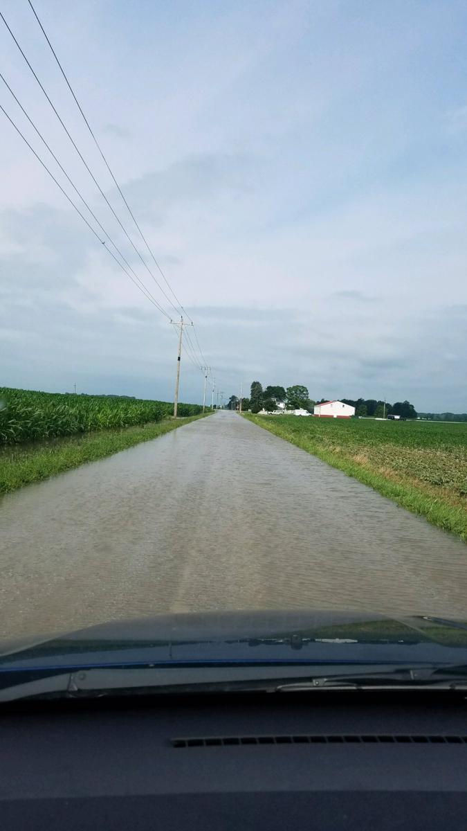
Flooding
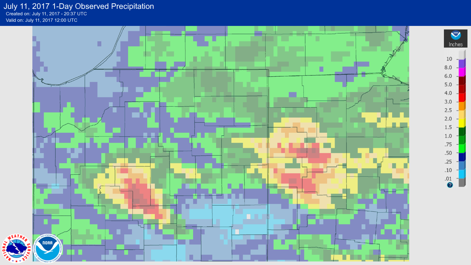
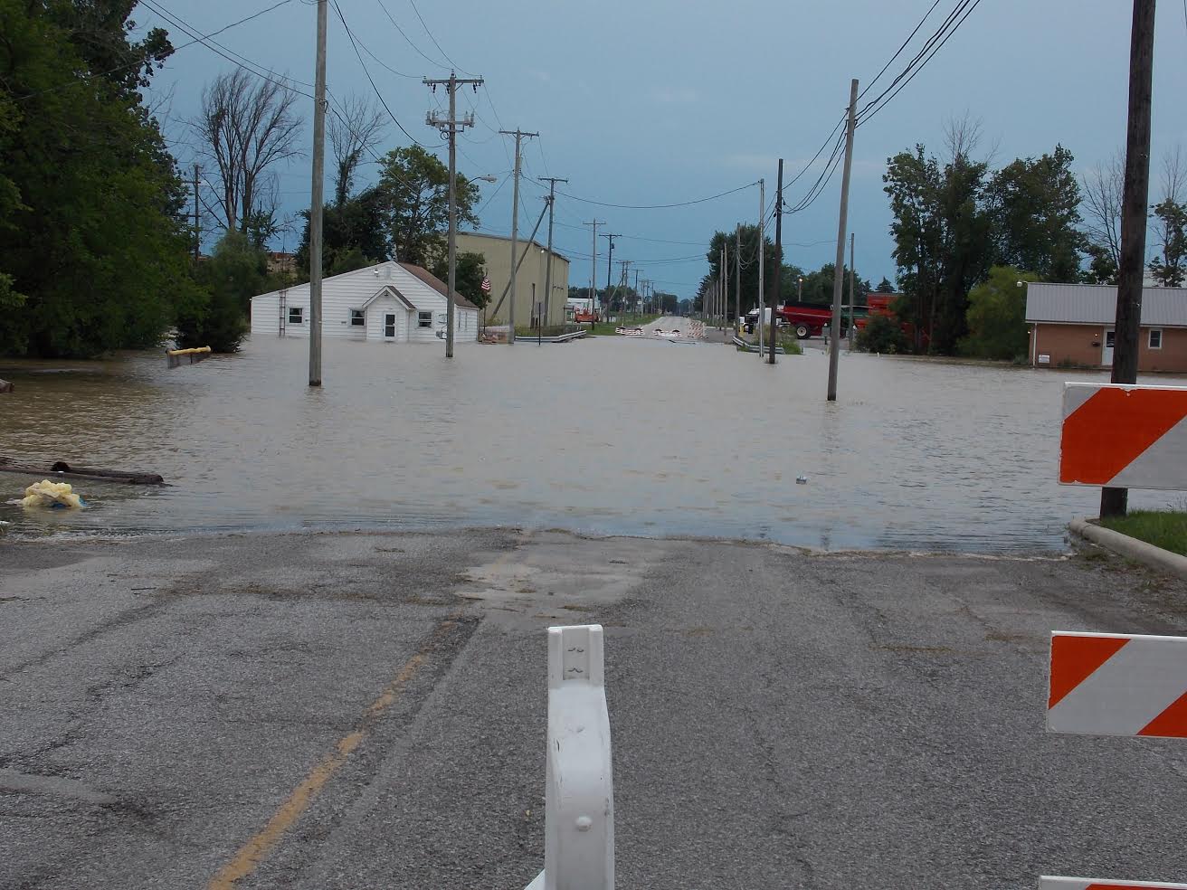
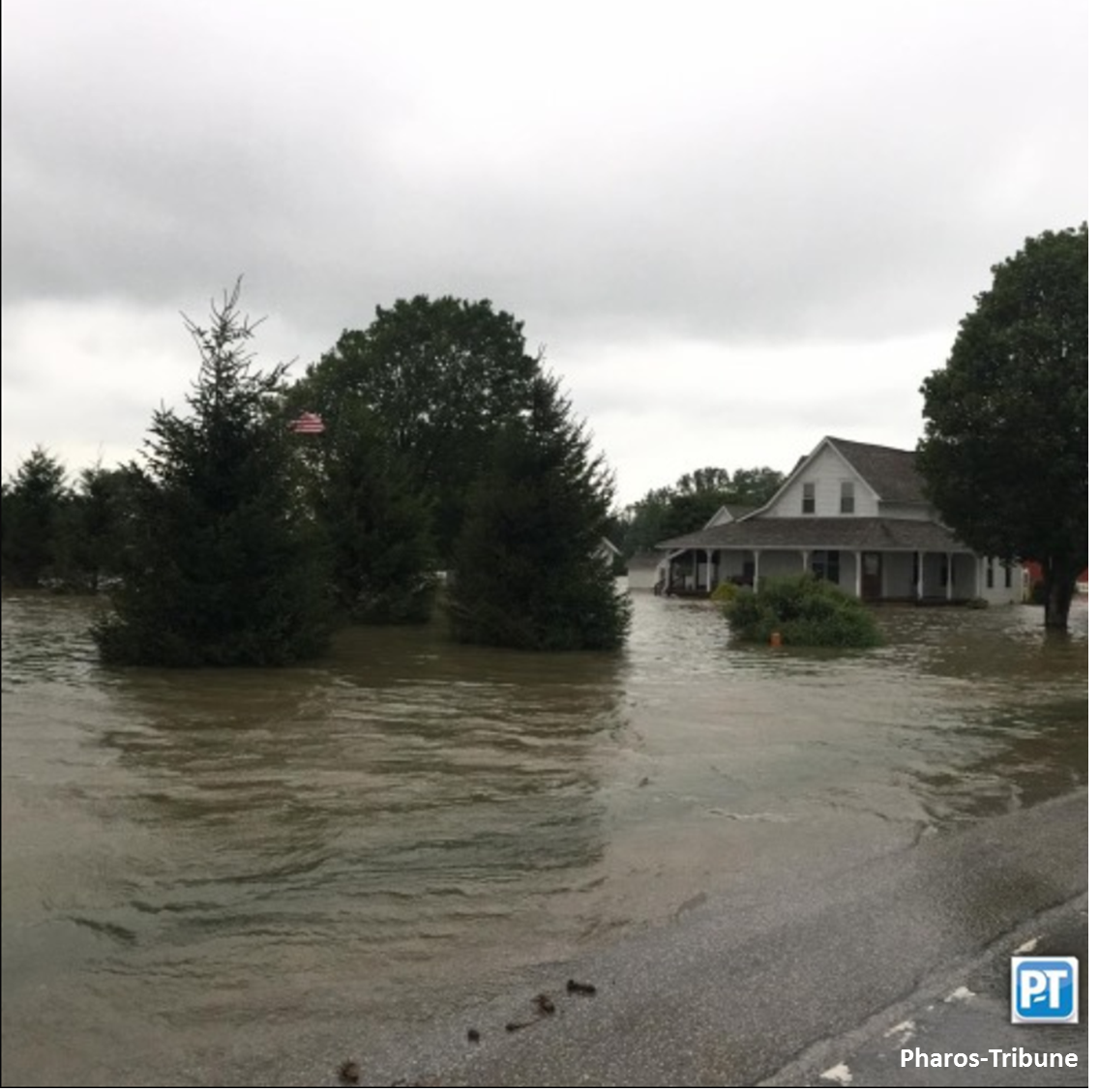
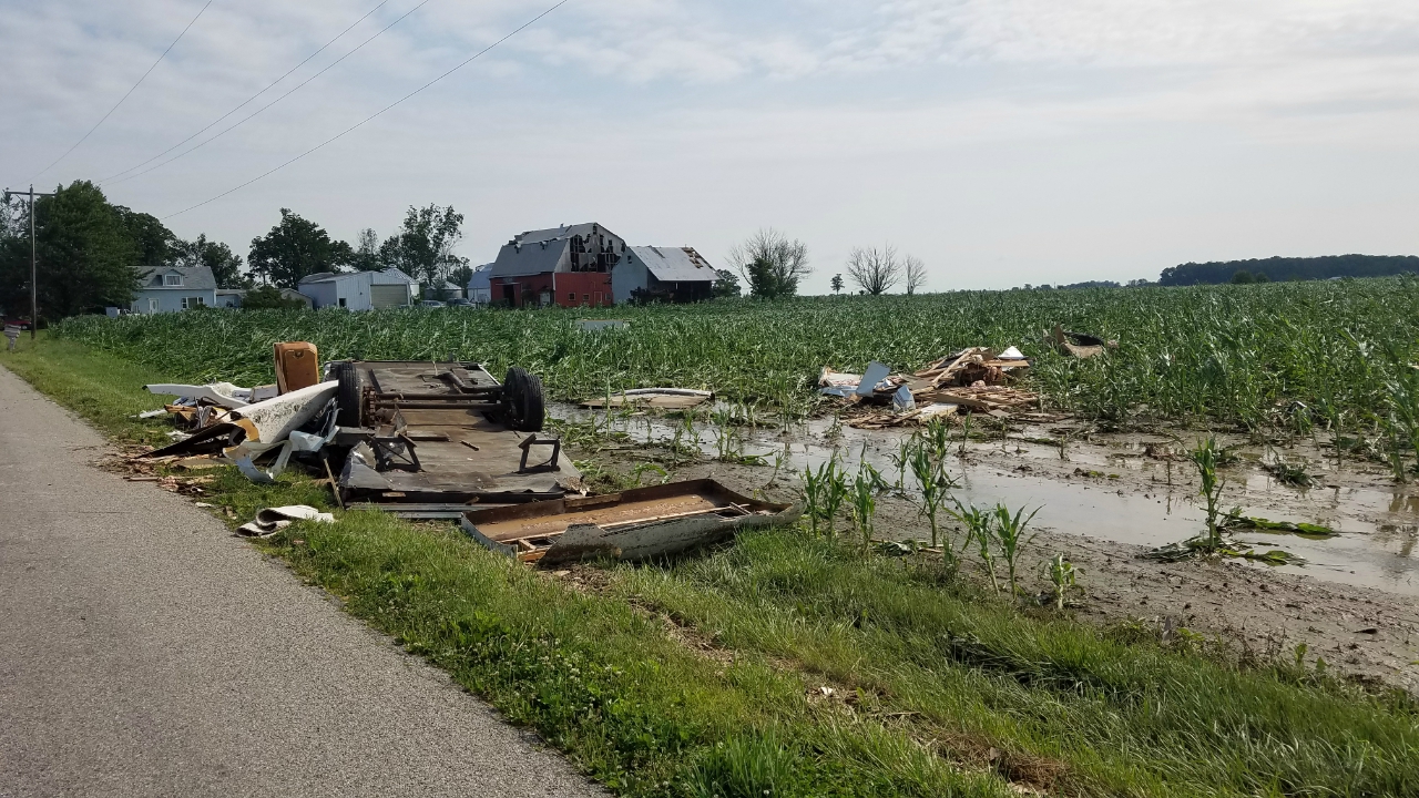
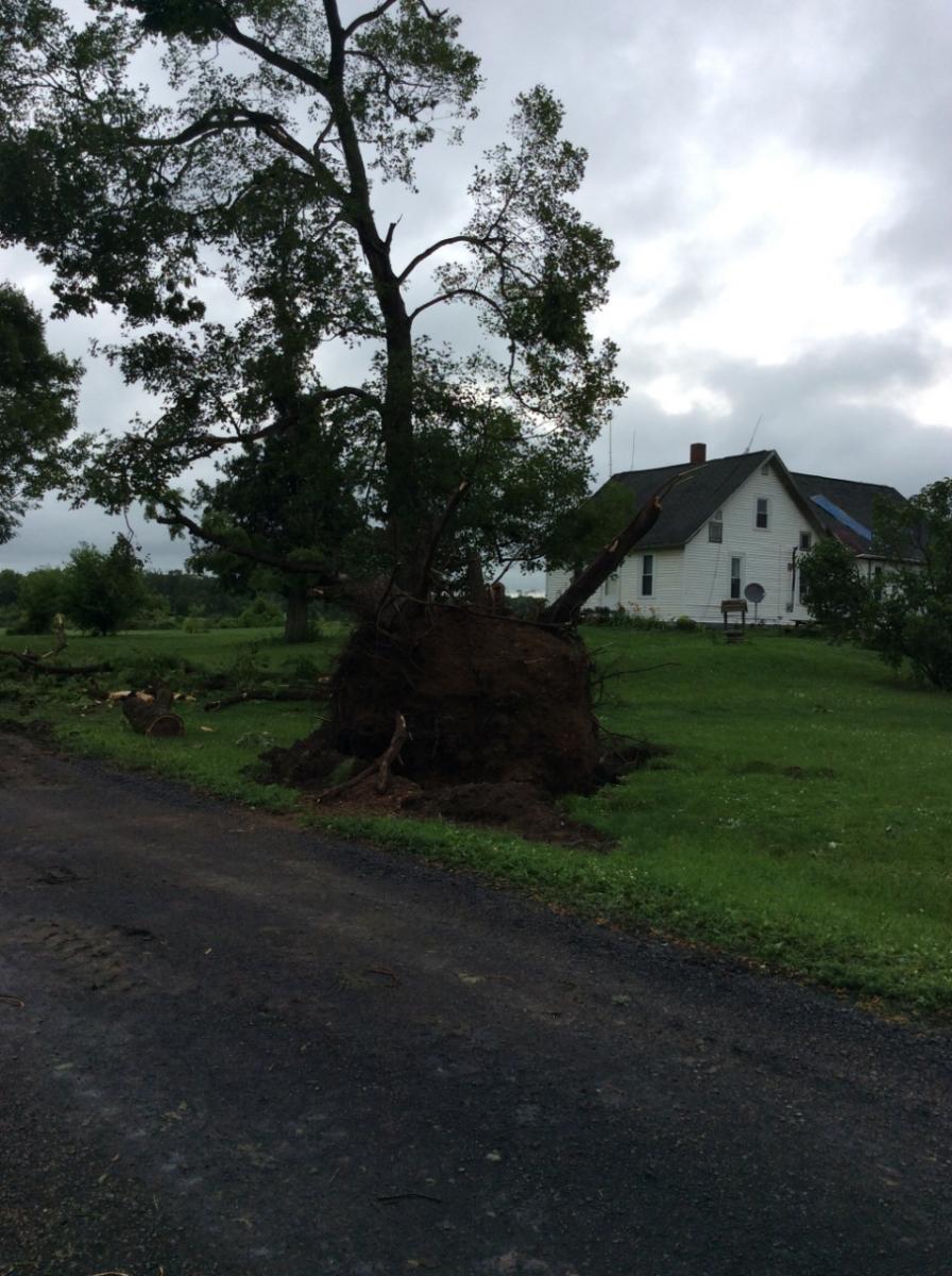
Flooding was reported in several areas due to the heavy rainfall received during storms the 9th-10th of July. Van Wert County, OH declared a local emergency in response to agricultural flooding and flooded roadways. There were reports of people sheltering in place at a factory in SW Delphos due to water surrounding the facility on July 11th, 2017. Extensive flooding was also reported in Cass County, IN. Our storm survey crew took several photos of the flooding there, and near Carroll, IN (IND's forecast area). The numerous road closures made it difficult to survey the tornado damage.
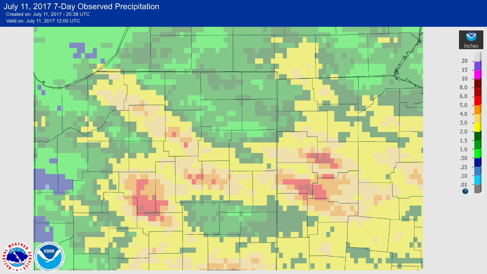
Rainfall Totals
 |
 |
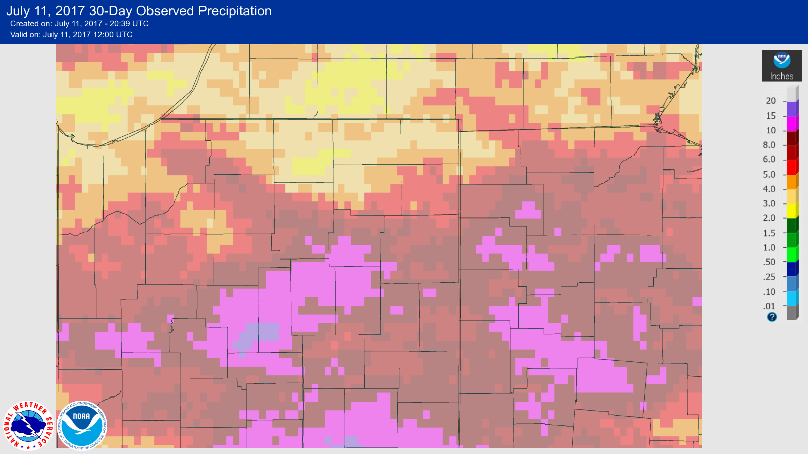 |
| 24 Hour Precipitation Estimates from our AHPS page. | 7 Day Precipitation Estimates from our AHPS page. | 30 Day Precipitation Estimates from our AHPS page. |
 |
 |
 |
| Flooding in Delphos, OH. Photo by Rick McCoyVan Wert EMA | SR 29 South of Logansport, IN. Photo courtesy of the Pharos-Tribune. Visit their facebook, and you can do a 360 degree view! | Cass, IN. Water over the road. NWS Storm Survey. |
Photos & Video:
Thanks to the amazing spotters in our forecast area, we had numerous pictures/videos sent to us of the storms and tornadoes that developed in this event. Below are what we received. Have a photo? Send it to our webmaster (along with where/when you took it) at w-iwx.webmaster@noaa.gov
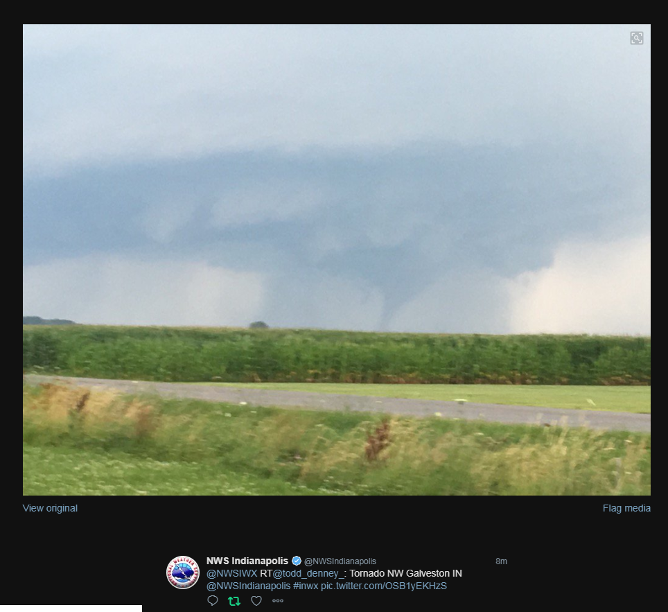
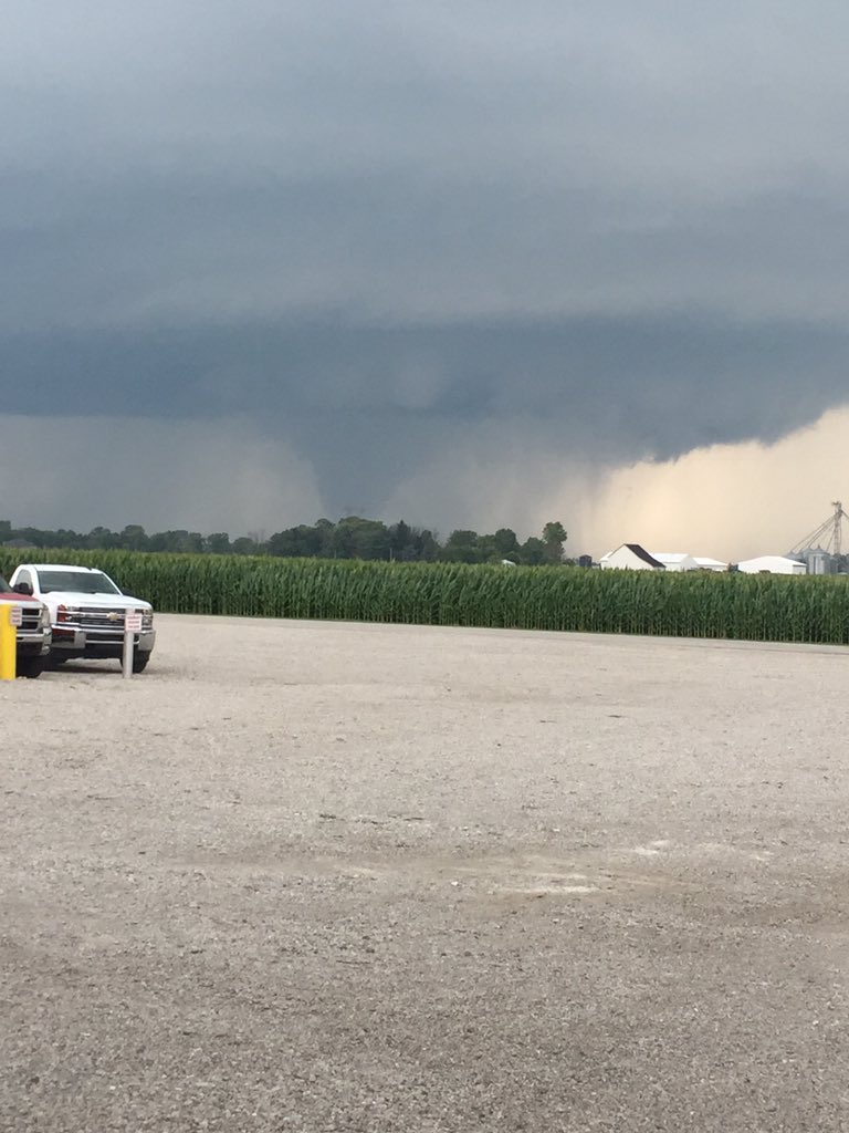
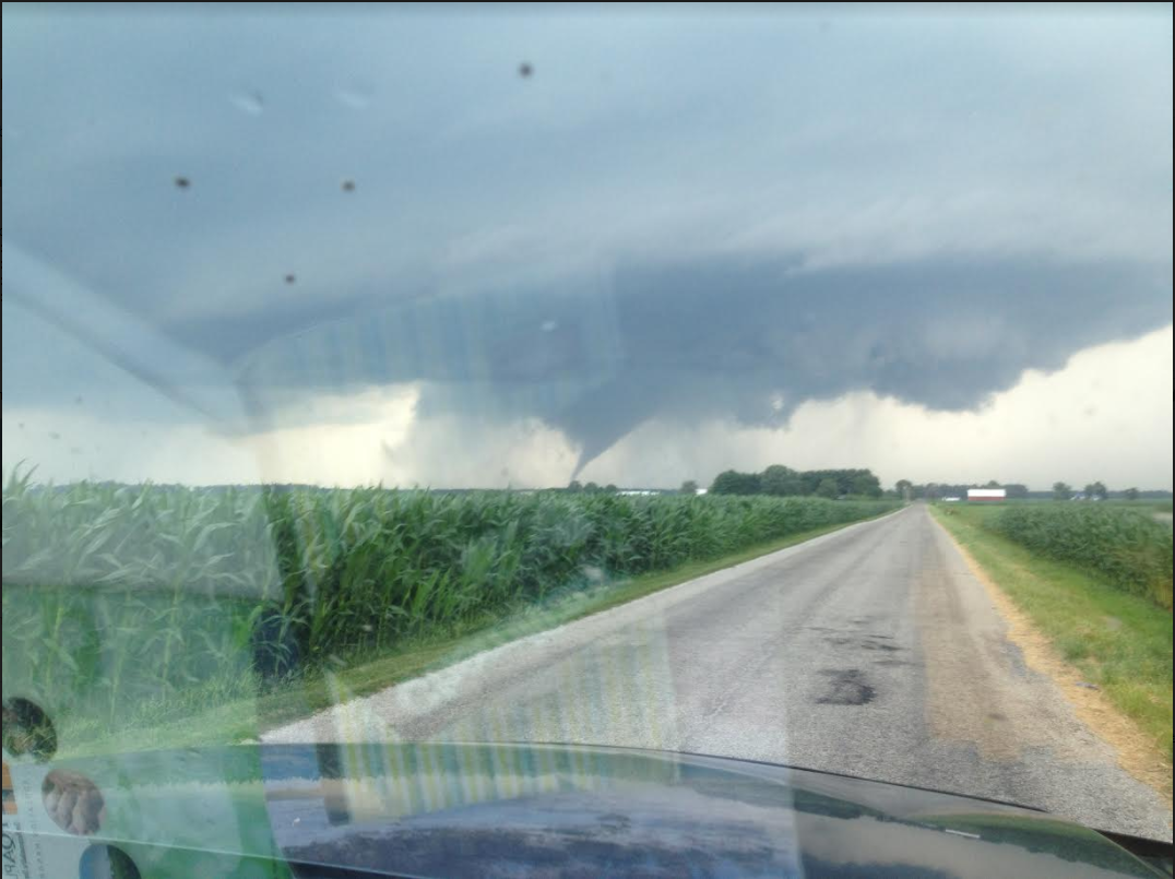
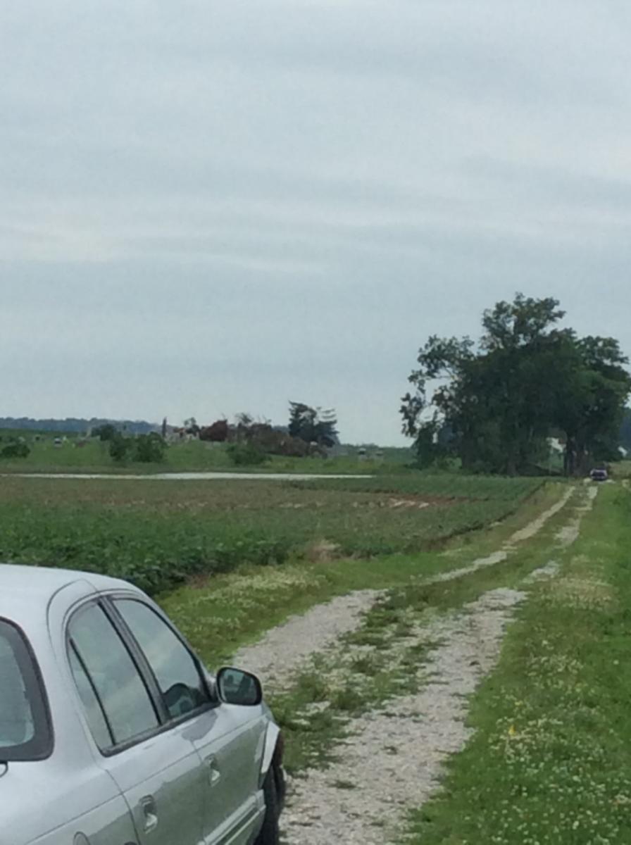
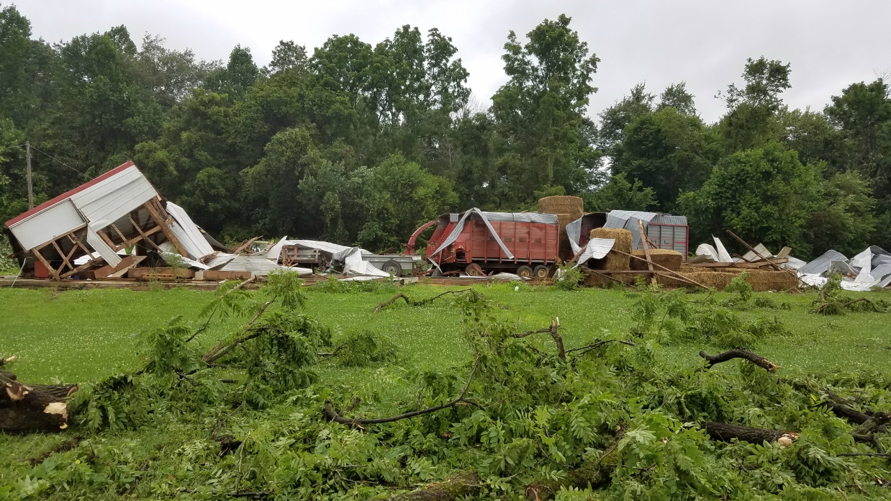
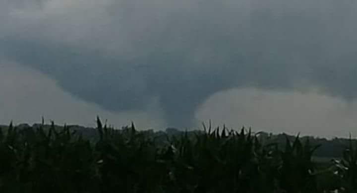
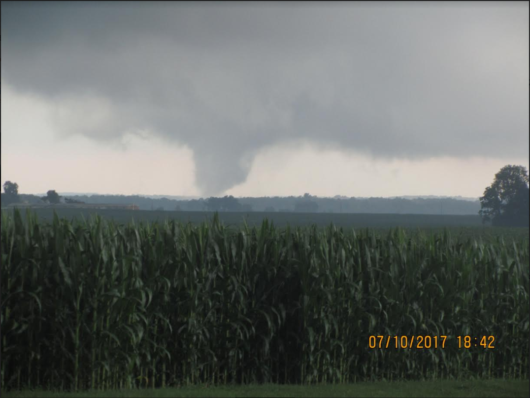
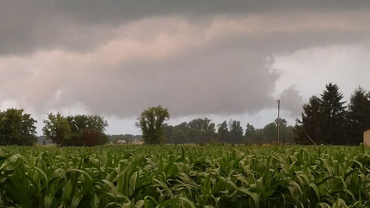
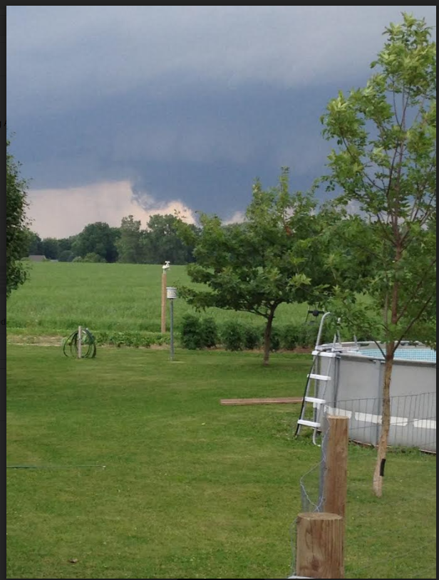
Cass County, IN
 |
 |
 |
 |
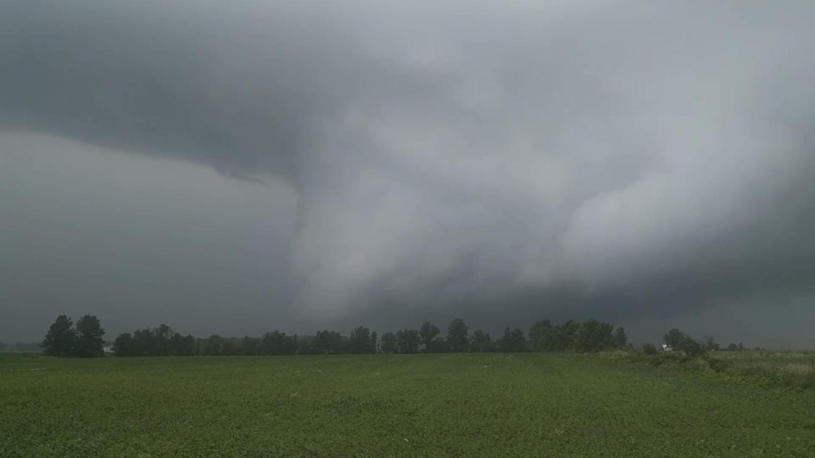
| Tornado seen from near Galveston, IN. Photo by Todd Denney. | Tornado seen from near Galveston. Photo by Karlie Merrell. | Tornado seen from near Young America, IN. Photo by Bart Kraning | Tornado in Cass County, IN. Photo by Candyse Arivett |
 |
 |
 |
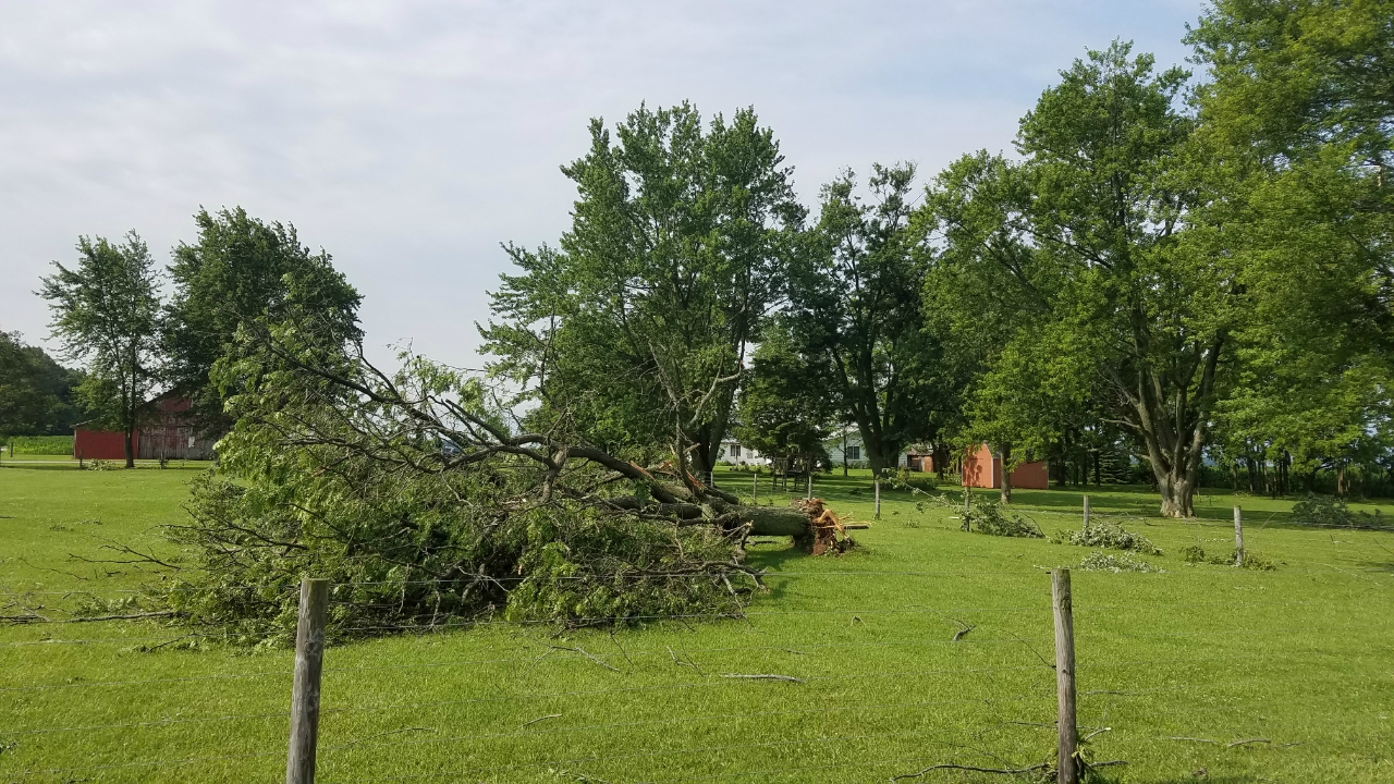 |
| Tornado Damage near the Cass/Carroll County Line (Deer Creek). NWS Survey | Tornado Damage near the Cass/Carroll County Line (Deer Creek). NWS Survey | Tornado Damage near the Cass/Carroll County Line (Deer Creek). NWS Survey | Tornado damage on S 100 E. Near Deer Creek. NWS Survey. |
 |
 |
 |
 |
| Tornado damage on S 200 E. Near Deer Creek. NWS Survey. | Tornado damage on S 200 E. Near Deer Creek. NWS Survey. | Tornado damage on S 200 E. Near Deer Creek. NWS Survey. | Tornado damage on S 200 E. Near Deacon, IN. NWS Survey. |
 |
 |
 |
| Tornado Damage just west of S 300 E. Near Deacon, IN NWS Survey | Tornado Near Deacon, IN. Photo by Forrest Hamilton. | Tornado near Lincoln, IN. Photo by John Tinney |
The video below was sent to us from Forrest Hamilton near Deacon, IN.
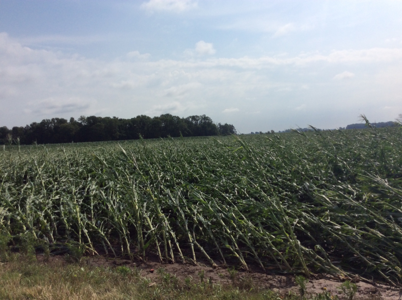
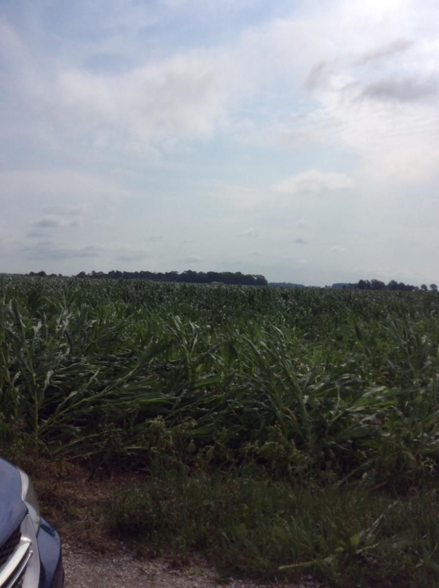
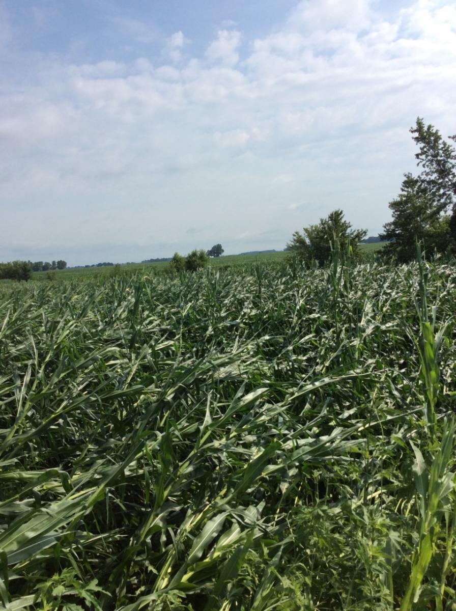
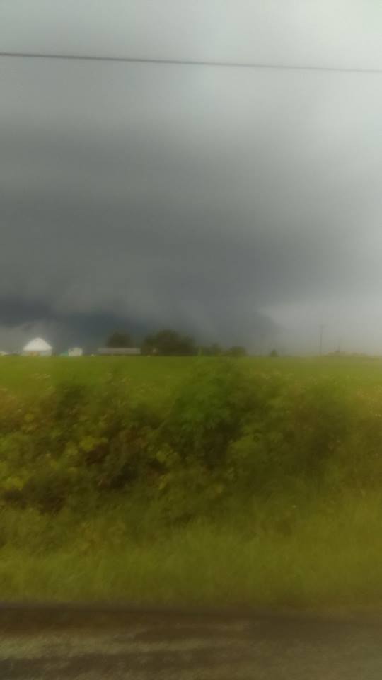
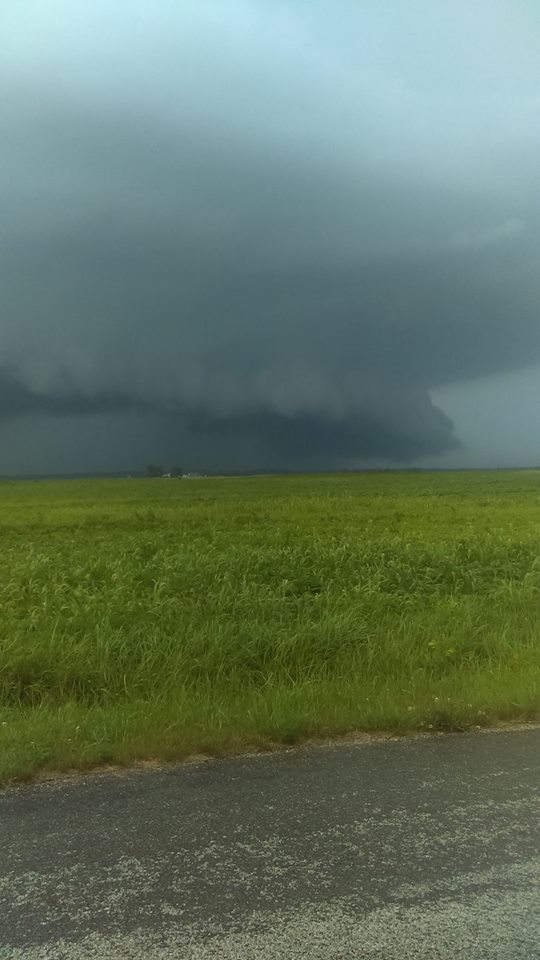
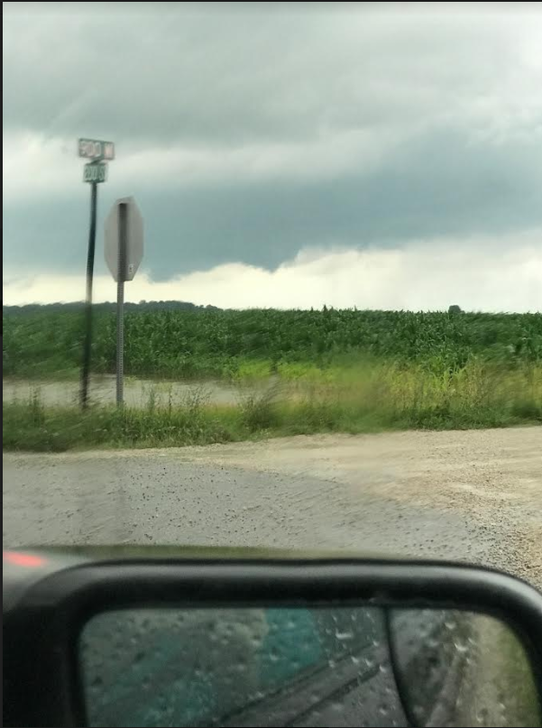
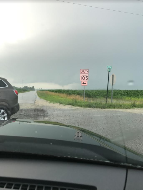
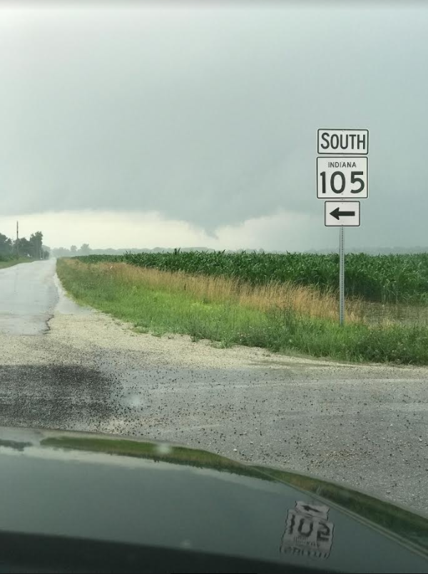
Miami County, IN
 |
 |
 |
 |
| Tornado Damage on E 850 N. (4 NE Denver, IN). NWS Storm Survey. | Tornado Damage on N 600 E. SW of Roann, IN. NWS Storm Survey. | Tornado Damage on N 600 E. SW of Roann, IN. NWS Storm Survey. | Tornado in Miami County. Photo by Ben Kessler. |
<
 |
 |
 |
 |
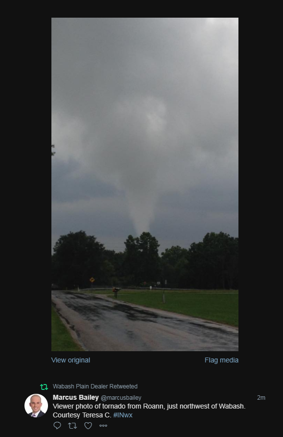
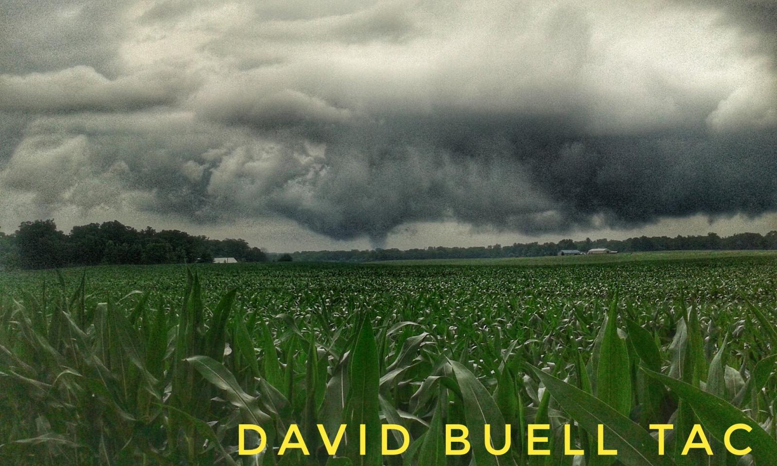
| Tornado SW of Roann, IN. Photo by David Summers. | SW of Roann, IN. Photo by Marcus Bailey. | Tornado in Miami County, IN. Photo by David Buell. | Photo looking southwest of Roann. Photo by Rob Cussen. |
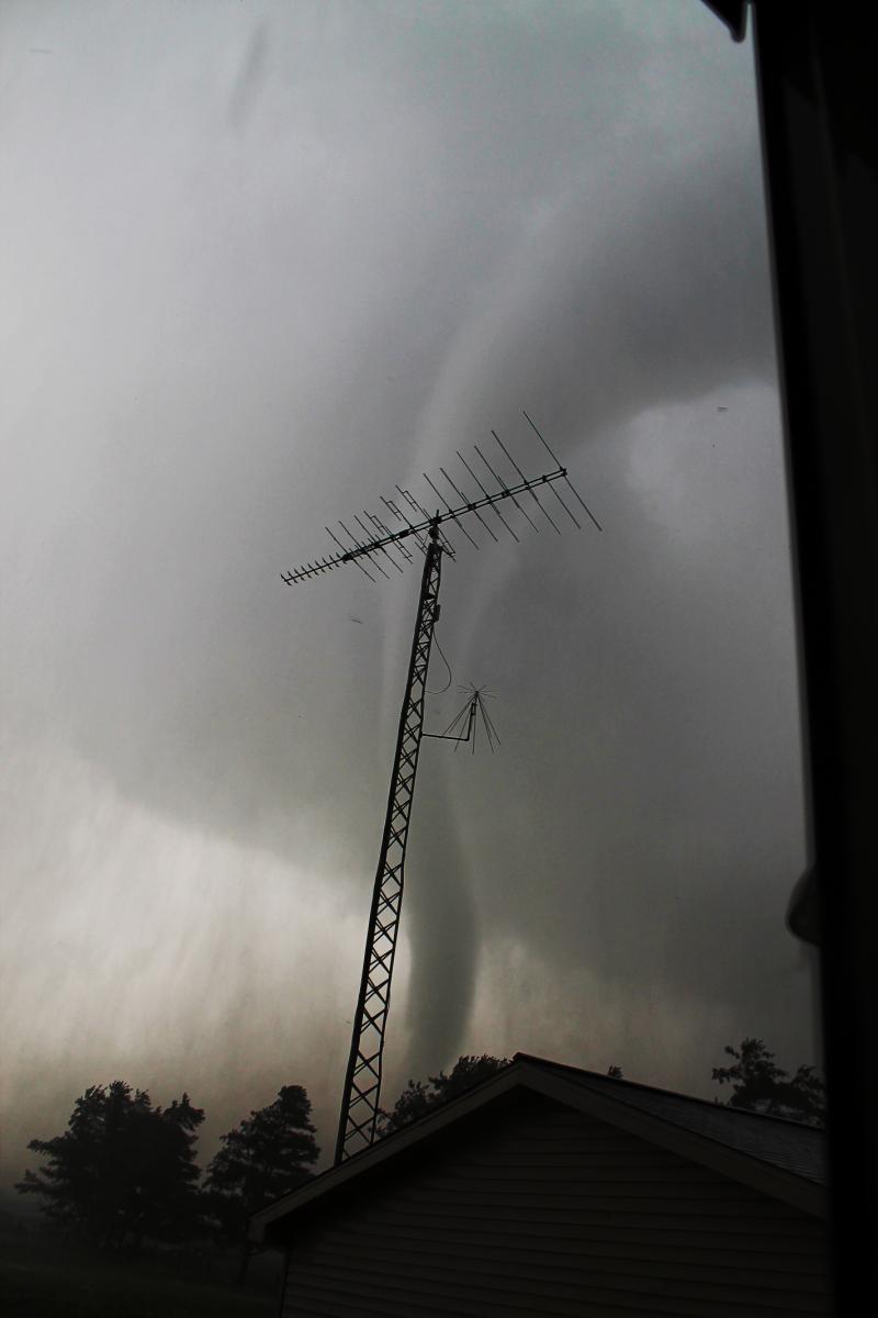
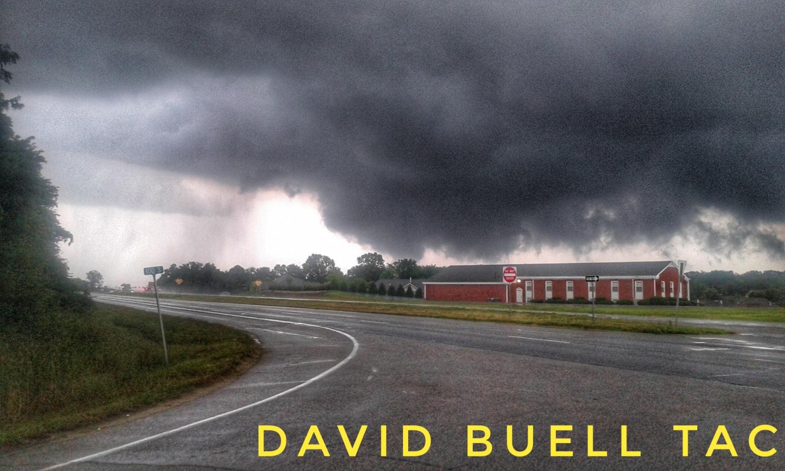
Wabash County, IN
 |
 |
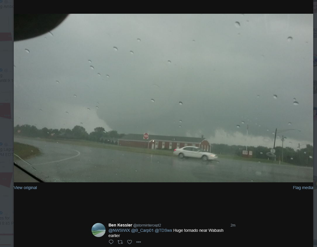 |
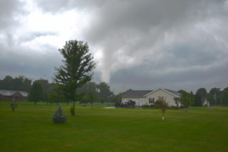
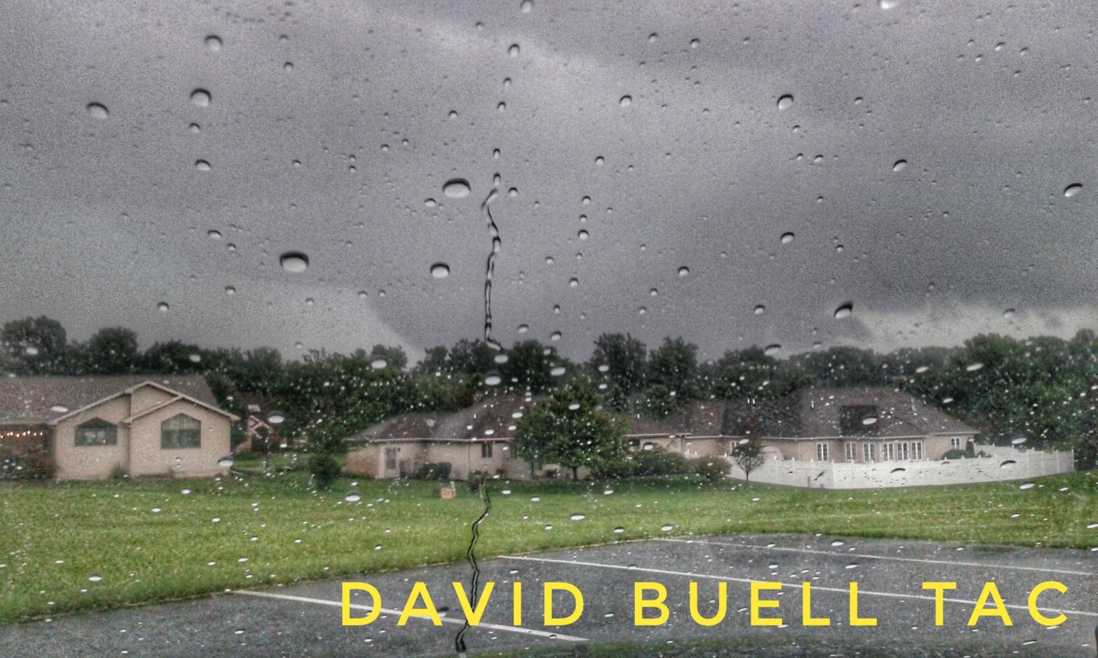
| Storm north of Wabash, IN. Photo taken by David Buell. W 100 S & US 24 (Wabash, IN). Looking North. | Storm north of Wabash, IN. Photo taken by David Buell. W 100 S & US 24 (Wabash, IN). Looking North. | Storm north of Wabash. (Cloud formation was most likely a wall cloud). Photo by Ben Kessler. |
 |
 |
 |
| Storm near Wabash, IN. Photo by Brendon Jaquish. | Storm near of Wabash, IN. Photo by Brendon Jaquish. | Storm near Wabash, IN. Photo by Brendon Jaquish. |
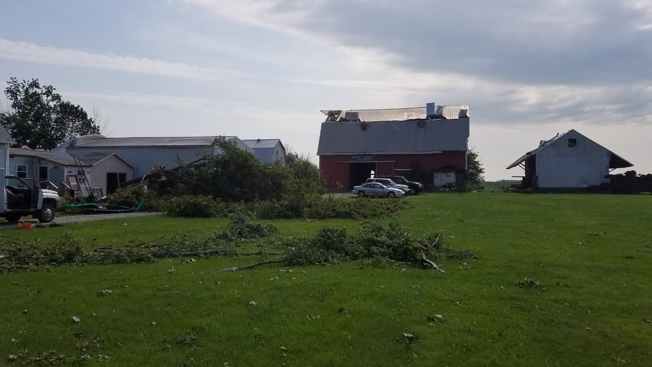
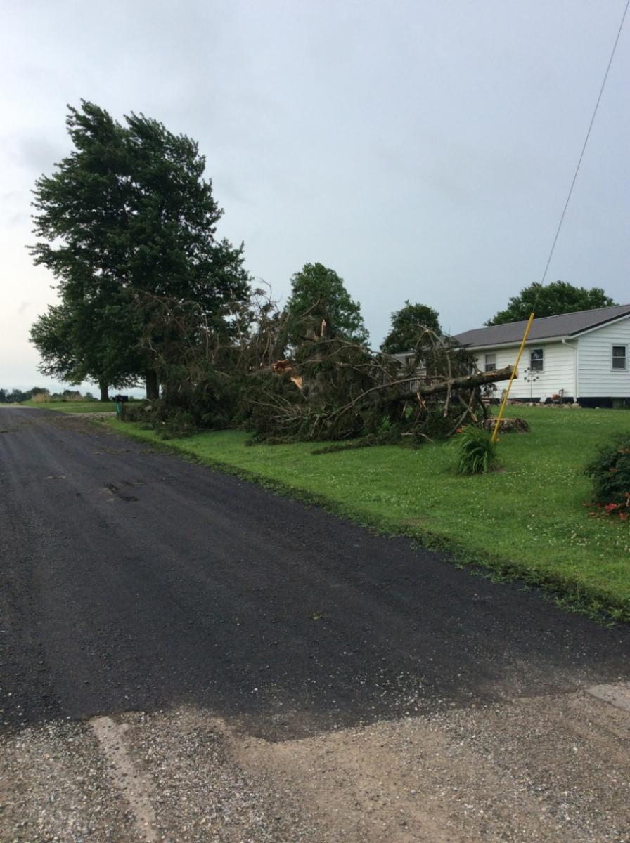
Huntington County, IN
 |
 |
 |
 |
| Photo by Tyler Elzey. After tornado dissipated. Andrews, IN. | Photo by Nick Stanley. Huntington County, IN | Photo by Nick Stanley. Huntington County, IN | Photo by Nick Stanley. Huntington County, IN |
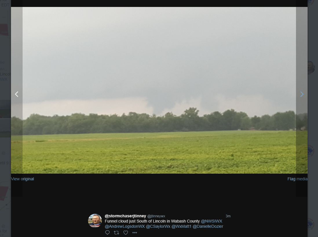
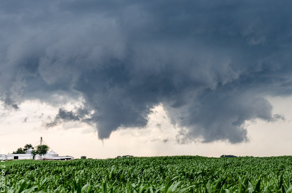
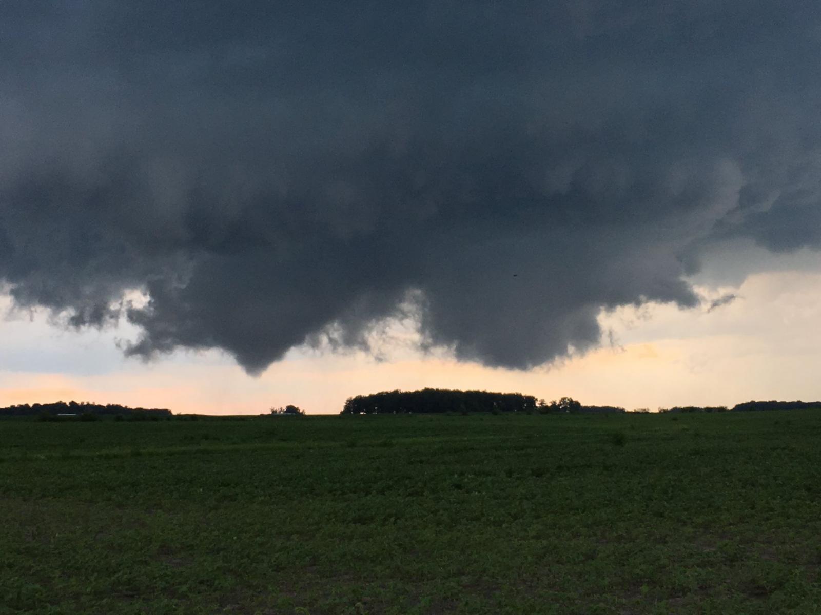
White County, IN
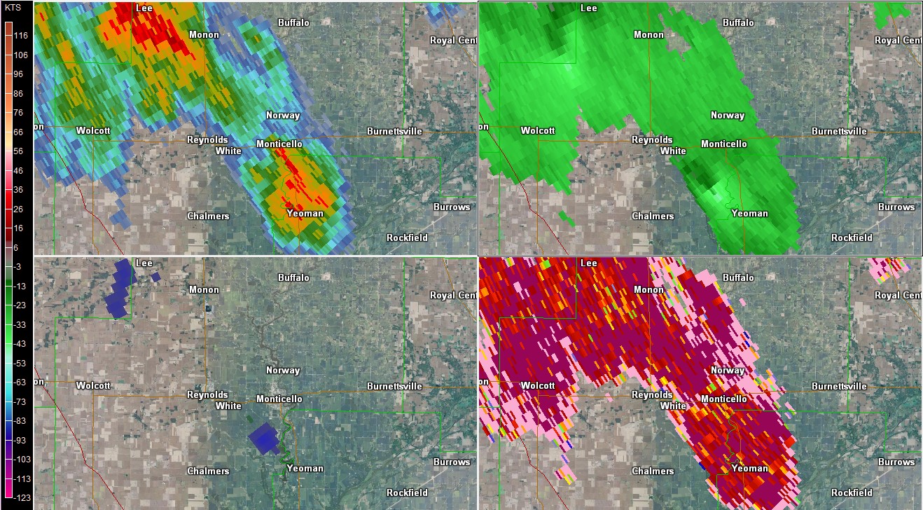
Some folks reported seeing a funnel cloud around the Monticello, IN and Reynolds, IN area. There were no reports of official touchdowns. From radar, rotation doesn't stand out too much due to distance from IWX-but you can see some weak rotation present as the storm developed. There were a couple of videos submitted too, which are featured here. How do you know the difference between a tornado and a funnel cloud? Tornadoes touch the ground-funnels do not! How can you tell? Sometimes it's hard to see whether it's touching the ground (and sometimes, the tornado is touching but it's not visible!)-so one way to know is to see if there is any debris being kicked up.
 |
 |
 |
| Radar Reflectivity (Top L), SR Velocity (Top R), NROT (Bot. L), and Correlation Coefficient (Bot R). Near Reynolds, IN/Monticello, IN. Time was around 6:45-6:55 pm EDT. GR2 Analyst | Funnel Cloud 3 miles south of Monticello, IN (White County, OH) Photo by Cameron Nixon. | Funnel Cloud 2SW White County Airport (Near Monticello, IN). Intersection of S 400 E road and E 400 S road. 6:45 pm EDT. Photo by Chris Bray. |
This video of the funnel cloud was taken by Chris Bray from Monticello, IN. He was at the intersection of S 400 E & E 400 S rd, which is about 2 miles SW of the White County Airport.
This video of the funnel cloud was taken by Roberta Yerk, who was near Reynolds, IN.
Other Photos
Here are a couple of other photos we received from around the area.
 |
 |
| Wauseon, OH (Henry County, OH) Photo by Tara Sausser. | Youngstown, Ohio. Photo by Alvin Hamilton |
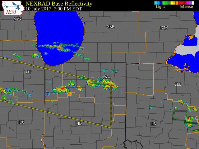
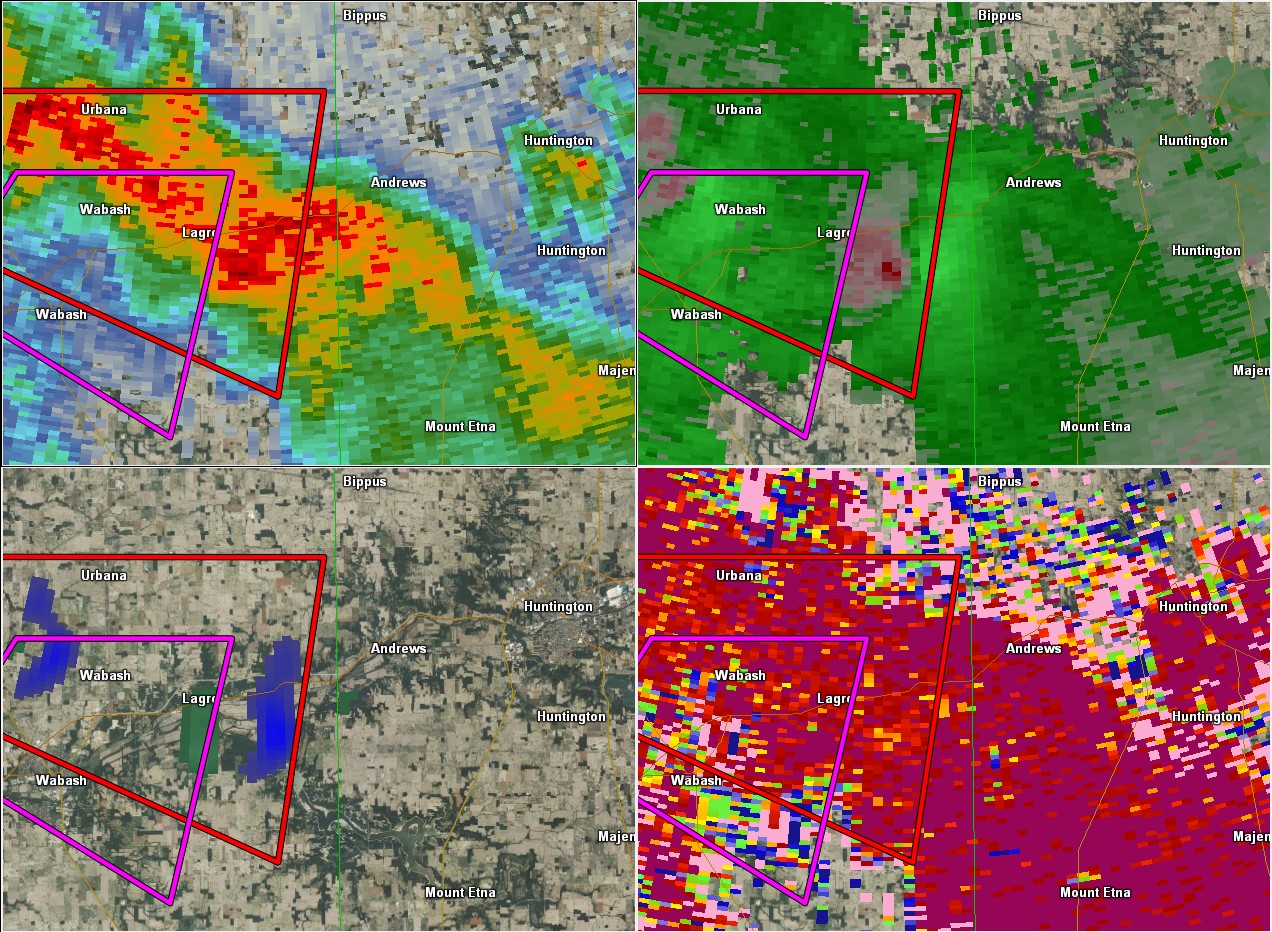
Radar:
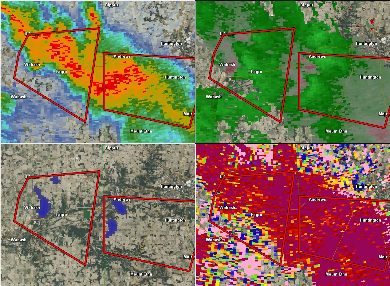
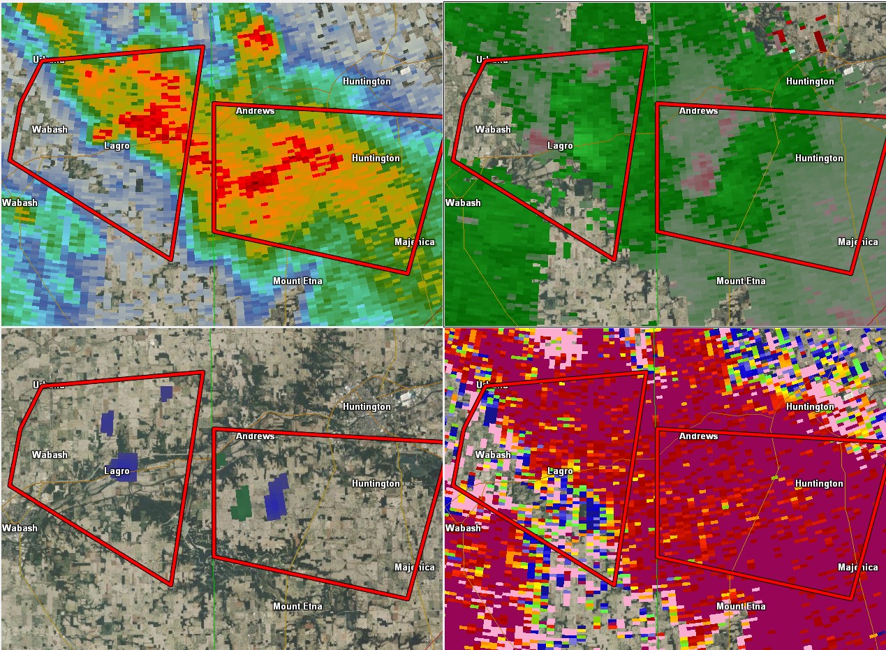
Below is a radar loop showing the entire event (Fig. 1). Additionally, screenshots of the tornadoes that were verified either by damage (Cass/Miami, IN) or by photo/Video (Wabash, IN) are shown in Figures 2, 3, & 4. The circulation from Wabash/Lagro crossed eastward into Huntington county, IN (which prompted the warning for Huntington, IN) before dying out. A second circulation did form behind the initial Wabash storm near Lagro, and that one also moved into Huntington County (near Andrews, IN). We did not find any damage in Wabash or Huntington, IN.
 |
 |
|
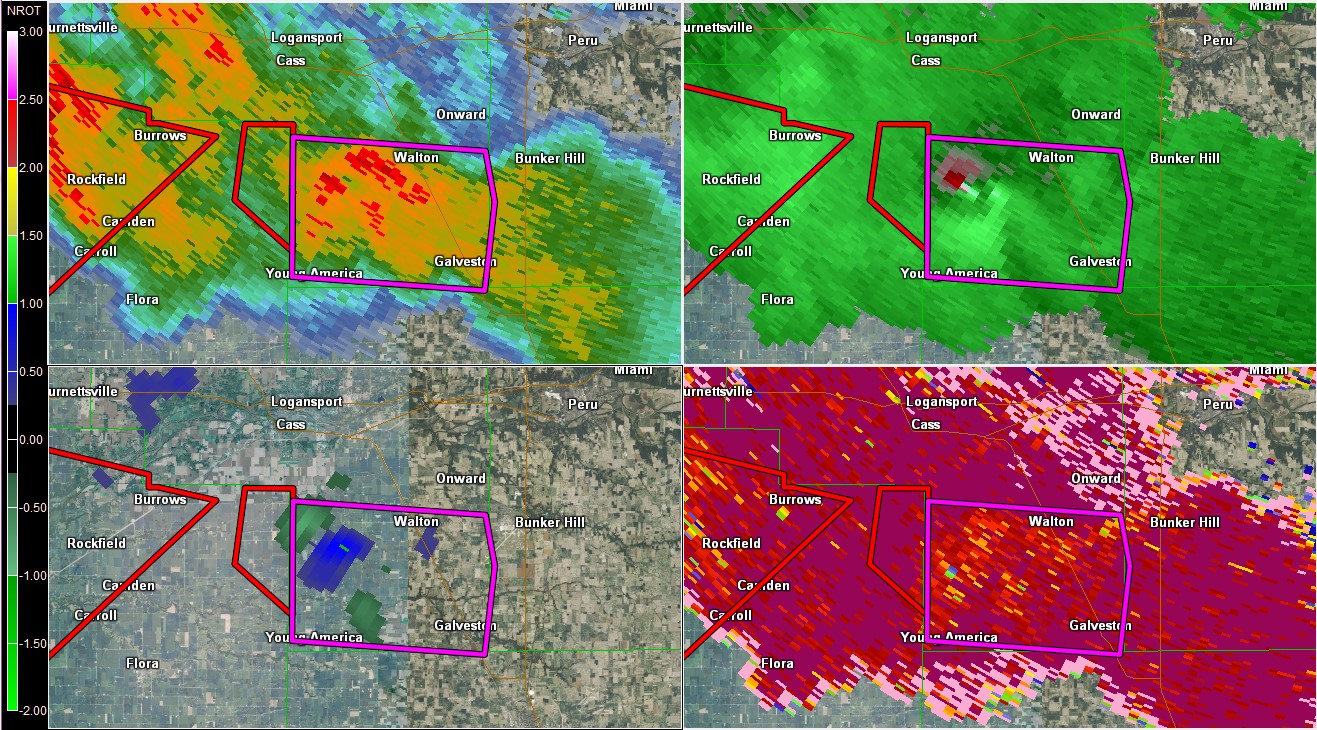 |
| Fig. 1. Radar Loop from entire event July 10th, 2017. Image from IEM. | Fig. 2. Radar Reflectivity (Left) and SR Velocity (Right) for the Tornado southwest of Roann, IN. 7:59 PM EDT. Miami County, IN. Box is the Tornado Warning. GR2 Analyst | Fig. 3. Radar Reflectivity (Top L), SR Velocity (Top R), NROT (Bot. L), and Correlation Coefficient (Bot R). Tornado observed in Wabash, IN. 8:19 pm EDT. GR2 Analyst | Fig. 4. Radar Reflectivity (Top L), SR Velocity (Top R), NROT (Bot. L), and Correlation Coefficient (Bot R). EF-1 ranked tornado in Cass, IN. 8:03 EDT. GR2 Analyst |
 |
 |
 |
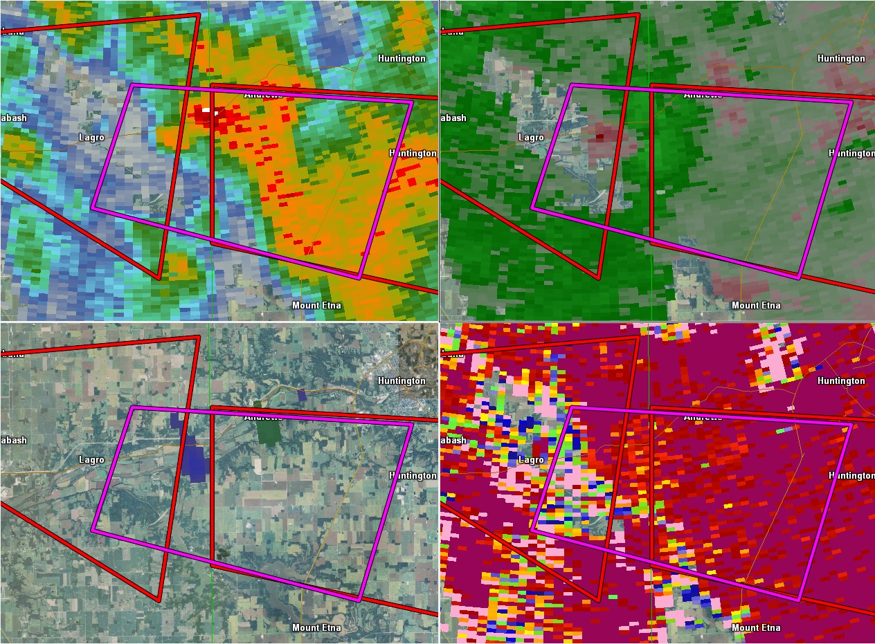 |
| Radar Reflectivity (Top L), SR Velocity (Top R), NROT (Bot. L), and Correlation Coefficient (Bot R). Storm in Wabash moving towards Huntington County, IN. Time was 8:41 PM EDT. GR2 Analyst | Radar Reflectivity (Top L), SR Velocity (Top R), NROT (Bot. L), and Correlation Coefficient (Bot R). Storm entering into Huntington Co. Next circulation develops near Lagro. 8:52 PM. GR2 Analyst | Radar Reflectivity (Top L), SR Velocity (Top R), NROT (Bot. L), and Correlation Coefficient (Bot R). Circulation in Lagro moving east, storm south of Andrews still in play. 8:58 PM. GR2 Analyst | Radar Reflectivity (Top L), SR Velocity (Top R), NROT (Bot. L), and Correlation Coefficient (Bot R). 8:58 PM. Lagros circulation gets to the county line and diminishes in intensity. GR2 Analyst |
Storm Reports
PRELIMINARY LOCAL STORM REPORT...SUMMARY
NATIONAL WEATHER SERVICE NORTHERN INDIANA
133 AM EDT TUE JUL 11 2017

..TIME...   ...EVENT...      ...CITY LOCATION...     ...LAT.LON...
..DATE...   ....MAG....      ..COUNTY LOCATION..ST.. ...SOURCE....
            ..REMARKS..

1235 AM     HEAVY RAIN       GULIVOIRE PARK          41.61N 86.24W
07/11/2017  M0.23 INCH       ST. JOSEPH         IN   MESONET

            MESONET STATION E6775, GULIVOIRE PARK.

1232 AM     HEAVY RAIN       KALIDA                  40.98N 84.20W
07/11/2017  M4.73 INCH       PUTNAM             OH   MESONET

            MESONET STATION D3681, KALIDA.

1229 AM     FLOOD            DEACON                  40.63N 86.32W
07/11/2017                   CASS               IN   EMERGENCY MNGR

            FLOODING OF HIGHWAYS AND COUNTY ROADS IN
            SOUTHERN PART OF CASS COUNTY.

1219 AM     HEAVY RAIN       VENEDOCIA               40.79N 84.46W
07/11/2017  M6.30 INCH       VAN WERT           OH   EMERGENCY MNGR

            STORM TOTAL FROM TODAY.

1219 AM     FLOOD            VAN WERT                40.86N 84.58W
07/11/2017                   VAN WERT           OH   EMERGENCY MNGR

            EM REPORTED MANY ROADS IN SOUTHERN VAN WERT
            COUNTY ARE UNDERWATER/IMPASSIBLE FROM THE
            EXTENSIVE RAINFALL RECEIVED TODAY.

1045 PM     HAIL             SPENCERVILLE            40.71N 84.35W
07/10/2017  E1.00 INCH       ALLEN              OH   BROADCAST MEDIA

            DELAYED REPORT. HAIL IMAGES RELAYED VIA LIMA
            MEDIA. PICTURES LOOK SLIGHTLY LARGER THAN
            QUARTER SIZED.

1012 PM     HEAVY RAIN       JONESTOWN               40.77N 84.51W
07/10/2017  M5.22 INCH       VAN WERT           OH   EMERGENCY MNGR

            STORM TOTAL.

1012 PM     LIGHTNING        JONESTOWN               40.77N 84.51W
07/10/2017                   VAN WERT           OH   EMERGENCY MNGR

            REPORT OF A HOUSE FIRE DUE TO LIGHTNING.

1012 PM     FLOOD            JONESTOWN               40.77N 84.51W
07/10/2017                   VAN WERT           OH   EMERGENCY MNGR

            REPORTED 5.22" OF RAIN. SEVERAL VEHICLES
            STRANDED IN HIGH WATER.

0900 PM     TORNADO          2 SW ANDREWS            40.84N 85.63W
07/10/2017                   HUNTINGTON         IN   TRAINED SPOTTER

            TORNADO ON THE GROUND.

0859 PM     FLOOD            2 S SPEICHERVILLE       40.83N 85.80W
07/10/2017                   WABASH             IN   PUBLIC

            WATER RUNNING OVER THE ROAD ON US 24 BETWEEN
            WABASH AND LARGO, IN.

0845 PM     TORNADO          4 NE LINCOLNVILLE       40.80N 85.63W
07/10/2017                   HUNTINGTON         IN   PUBLIC

            DEBRIS REPORTED UNDER WALL CLOUD, 1.5 MILES
            WEST OF 900W AND 200S.

0842 PM     HEAVY RAIN       1 NNE RIVARE            40.83N 84.83W
07/10/2017  M5.50 INCH       ADAMS              IN   PUBLIC

            SINCE 12AM.

0835 PM     TORNADO          2 NW MIAMI              40.63N 86.13W
07/10/2017                   MIAMI              IN   TRAINED SPOTTER

            TORNADO REPORTED. DEBRIS OBSERVED.

0813 PM     TORNADO          4 SSE ROANN             40.85N 85.89W
07/10/2017                   WABASH             IN   TRAINED SPOTTER

            ROPE TORNADO REPORTED ON THE GROUND.

0805 PM     TORNADO          2 SW DEACON             40.62N 86.34W
07/10/2017                   CASS               IN   LAW ENFORCEMENT

            TORNADO ON THE GROUND.

0800 PM     TORNADO          2 S STOCKDALE           40.88N 85.95W
07/10/2017                   MIAMI              IN   TRAINED SPOTTER

            TORNADO ON THE GROUND.

0800 PM     TSTM WND DMG     3 SE CURRYVILLE         40.76N 85.03W
07/10/2017                   ADAMS              IN   EMERGENCY MNGR

            TREE DAMAGE.

0758 PM     TORNADO          2 ENE DEACON            40.64N 86.28W
07/10/2017                   CASS               IN   EMERGENCY MNGR

            STRUCTURAL DAMAGE NEAR 850 SOUTH (SPECIFICS
            UNAVAILABLE). ALSO REPORTS ON 500 E. REPORTS
            OF DOWNED POWER LINES IN THE AREA. TIME
            ESTIMATED BY RADAR.

0755 PM     TSTM WND DMG     1 W DECATUR             40.83N 84.94W
07/10/2017                   ADAMS              IN   PUBLIC

            TREES DOWN.

1240 PM     FLOOD            LIMA                    40.74N 84.11W
07/10/2017                   ALLEN              OH   BROADCAST MEDIA

            NUMEROUS STREETS FLOODED IN AND AROUND LIMA.
            SOME STREETS ARE BEING CLOSED OFF BY POLICE.

1233 PM     FLOOD            3 SW LIBERTY CENTER     41.41N 84.05W
07/10/2017                   HENRY              OH   PUBLIC

            ROAD CLOSED DUE TO HIGH WATER UNTIL WATER
            RECEDES. A VEHICLE WAS STUCK IN HIGH WATER.
0255 AM     FLOOD            1 SW LOGANSPORT         40.74N 86.38W
07/11/2017                   CASS               IN   PUBLIC

            FLOODING REPORTED IN SOUTH PART OF
            LOGANSPORT.
0400 AM     FLOOD            ANOKA                   40.72N 86.28W
07/11/2017                   CASS               IN   LAW ENFORCEMENT

            U.S. ROUTE 35 CLOSED DUE TO FLOODING.
0425 AM     FLOOD            SPENCERVILLE            40.71N 84.35W
07/11/2017                   ALLEN              OH   LAW ENFORCEMENT

            MANY ROADS CLOSED DUE TO FLOODING IN ALLEN
            COUNTY OHIO.
0654 AM     FLOOD            DEACON                  40.63N 86.32W
07/11/2017                   CASS               IN   EMERGENCY MNGR

            SEVERAL HIGHWAYS AND MANY COUNTY ROADS
            CLOSED DUE TO FLOODING IN SOUTHERN CASS
            COUNTY. TWO ROADS WASHED OUT AND ONE BRIDGE
            COLLAPSED IN THIS AREA.
0257 PM     FLOOD            DELPHOS                 40.84N 84.35W
07/11/2017                   VAN WERT           OH   EMERGENCY MNGR

            PEOPLE AT A FACTORY ARE SHELTERING IN PLACE
            BECAUSE THE FACTORY IS SURROUNDED BY WATER.
            WORKERS THAT HAVE LEFT HAVE WALKED ON
            RAILROAD TRACKS TO GET OUT.
Rain Reports
Public Information Statement
National Weather Service Northern Indiana
1254 AM EDT Tue Jul 11 2017

...Latest Rainfall Reports from Today...

Location                     Amount    Time/Date       Lat/Lon

...Indiana...

...Adams County...
1 NNE Rivare                 5.50 in   0842 PM 07/10   40.83N/84.83W
Linn Grove                   0.32 in   1145 PM 07/10   40.66N/85.03W

...Allen County...
Woodburn                     2.66 in   0800 AM 07/11   41.14N/84.86W
1 NW Fort Wayne              2.30 in   1210 AM 07/11   41.11N/85.17W
4 N New Haven                1.82 in   1230 AM 07/11   41.13N/85.03W
4 NNW New Haven              1.55 in   1215 PM 07/10   41.12N/85.06W
2 ENE Nine Mile              1.06 in   0333 PM 07/10   40.99N/85.19W
3 NE Nine Mile               1.06 in   1230 AM 07/11   41.02N/85.18W
2 SSW Huntertown             0.97 in   1232 AM 07/11   41.20N/85.19W
Rolling Hills                0.56 in   0832 PM 07/10   41.03N/85.29W

...Cass County...
3 N Logansport               3.48 in   0300 AM 07/11   40.80N/86.35W
Galveston                    4.80 in   0800 AM 07/11   40.57N/86.17W

...Dekalb County...
Auburn                       1.19 in   0800 AM 07/11   41.37N/85.05W

...Elkhart County...
Goshen 6ne                   1.37 in   0800 AM 07/11   41.65N/85.75W
Goshen 3sw                   0.97 in   0700 PM 07/10   41.56N/85.88W
Goshen Municipal Airport     0.92 in   0753 PM 07/10   41.53N/85.79W
3 NE Osceola                 0.40 in   1230 AM 07/11   41.71N/86.04W
1 WNW Jimtown                0.30 in   1233 AM 07/11   41.64N/86.04W

...Fulton County...
Macy 3w                      1.52 in   0800 Am 07/11   40.95N/86.19W

...Huntington County...
1 ENE Bowerstown             1.75 in   1200 AM 07/11   40.90N/85.41W
1 N Markle                   1.60 in   0300 AM 07/10   40.85N/85.34W
3 NE Majenica                1.32 in   1233 AM 07/11   40.82N/85.41W
Huntington                   0.88 in   0700 AM 07/10   40.88N/85.51W
3 NW Huntington              0.52 in   1229 AM 07/11   40.93N/85.55W
2 NW Warren                  0.37 in   1145 PM 07/10   40.71N/85.45W

...Kosciusko County...
2 N North Webster            0.96 in   1221 AM 07/11   41.36N/85.70W
2 WSW Syracuse               0.87 in   1232 AM 07/11   41.41N/85.79W
Tippecanoe Lake              0.47 in   1230 AM 07/11   41.33N/85.77W
James Lake                   0.45 in   1233 AM 07/11   41.31N/85.72W
2 SW Warsaw                  0.39 in   1230 AM 07/11   41.21N/85.87W

...LaGrange County...
LaGrange                     1.57 in   0800 AM 07/11   41.65N/85.40W

...La Porte County...
1 ENE Fish Lake              0.43 in   1200 AM 07/11   41.58N/86.52W

...Marshall County...
Plymouth                     1.64 in   1230 AM 07/11   41.34N/86.31W
Bremen                       0.62 in   1229 AM 07/11   41.44N/86.16W

...Miami County...
Grissom Afb                  3.30 in   0310 AM 07/11   40.66N/86.15W
3 W Amboy                    1.28 in   1233 AM 07/11   40.59N/85.98W
Peru                         0.56 in   1230 AM 07/11   40.75N/86.07W

...Noble County...
3 NE Avilla                  1.27 in   1222 AM 07/11   41.40N/85.20W
Avilla 3sw                   0.93 in   0300 PM 07/10   41.35N/85.30W
1 E Big Lake                 0.84 in   1226 AM 07/11   41.28N/85.47W

...St. Joseph County...
South Bend                   0.60 in   1200 AM 07/11   41.70N/86.25W
2 ESE Mishawaka              0.37 in   1228 AM 07/11   41.65N/86.13W
1 NE South Bend              0.31 in   1223 AM 07/11   41.69N/86.25W
2 S New Carlisle             0.26 in   1227 AM 07/11   41.66N/86.51W

...Starke County...
North Judson                 0.88 in   0800 AM 07/11   41.21N/86.78W
3 N Brems                    0.25 in   1200 AM 07/11   41.39N/86.71W

...Steuben County...
Hamilton                     1.25 in   0800 AM 07/11   41.53N/89.89W
2 W Silver Lake              0.85 in   1215 AM 07/11   41.63N/85.11W
1 SE Crooked Lake            0.77 in   1233 AM 07/11   41.66N/85.02W

...Wabash County...
2 ESE Lagro                  1.20 in   1215 AM 07/11   40.81N/85.68W
1 SSE Roann                  0.72 in   1222 AM 07/11   40.89N/85.92W
Somerset                     0.34 in   1234 AM 07/11   40.66N/85.81W
2 ESE Somerset               0.32 in   1233 AM 07/11   40.66N/85.79W

...Wells County...
2 W Ossian                   2.11 in   0810 AM 07/11   40.87N/85.21W

...White County...
Norway                       1.22 in   1145 PM 07/10   40.78N/86.76W

...Whitley County...
2 NE Tri-Lakes               0.31 in   1229 AM 07/11   41.25N/85.45W

...Michigan...

...Berrien County...
Niles                        1.32 in   0330 PM 07/10   41.84N/86.27W
Southwest Michigan Regional  0.43 in   0753 PM 07/10   42.13N/86.43W
Saint Joseph                 0.43 in   1225 AM 07/11   42.10N/86.49W
Millburg                     0.26 in   1229 AM 07/11   42.12N/86.33W

...Cass County...
2 NW Granger                 0.45 in   1226 AM 07/11   41.77N/86.17W

...Hillsdale County...
Litchfield                   1.78 in   1234 AM 07/11   42.05N/84.75W
Jerome                       1.04 in   1232 AM 07/11   42.02N/84.46W
3 NW North Adams             0.82 in   0730 AM 07/10   42.01N/84.56W

...Ohio...

...Allen County...

Lima                         3.28 in   1230 AM 07/11   40.73N/84.12W
1 WNW Lima                   2.77 in   1259 AM 07/11   40.76N/84.13W
1 SSW Elida                  2.71 in   1229 AM 07/11   40.76N/84.21W
Bluffton                     1.57 in   1230 AM 07/11   40.89N/83.89W

...Defiance County...
Defiance Memorial Airport    1.69 in   0753 PM 07/10   41.34N/84.43W
Defiance                     2.61 in   0800 AM 07/11   41.28N/84.35W

...Fulton County...
1 NE Tedrow                  2.02 in   1229 AM 07/11   41.62N/84.19W
4 E Fayette                  1.85 in   1200 AM 07/11   41.66N/84.25W

...Henry County...
3 S Napoleon                 1.05 in   0900 AM 07/10   41.34N/84.12W
3 SE Mcclure                 1.80 in   0700 AM 07/11   41.33N/83.91W
Gallup                       0.70 in   0700 AM 07/10   41.46N/84.15W

...Paulding County...
1 NW Oakwood                 2.36 in   1233 AM 07/11   41.11N/84.40W
3 SW Charloe                 1.80 in   1225 AM 07/11   41.10N/84.48W

...Putnam County...
Kalida                       4.73 in   1232 AM 07/11   40.98N/84.20W
Pandora                      3.00 in   0500 PM 07/11   40.95N/83.96W
Columbus Grove               3.18 in   0844 AM 07/11   40.92N/84.05W
Leipsic                      0.95 in   1233 AM 07/11   41.10N/83.99W

...Van Wert County...
Venedocia                    6.30 in   1219 AM 07/11   40.79N/84.46W
Jonestown                    5.22 in   1012 PM 07/10   40.77N/84.51W
Convoy                       2.39 in   1243 AM 07/11   40.92N/84.71W
1 ENE Van Wert               2.32 in   1233 AM 07/11   40.87N/84.56W
Middle Point                 1.70 in   1234 AM 07/11   40.86N/84.45W

...Williams County...
Alvordton                    2.08 in   0700 AM 07/11   41.67N/84.42W
1 WSW Bryan                  0.90 in   1226 AM 07/11   41.46N/84.57W
2 S Pioneer                  1.33 in   0600 AM 07/11   41.64N/84.55W
Bryan 2se                    0.65 in   0700 AM 07/10   41.46N/84.53W

Observations are collected from a variety of sources with varying
equipment and exposures. We thank all volunteer weather observers
for their dedication. Not all data listed are considered official.

$$
Environment
Ingredients for severe weather include moisture, lift, instability, and wind shear. We had all of these ingredients on the evening of July 10, 2017. See the images below for details.
Scientific explanation of what caused this event:
Synoptic conditions
Synoptic quasi-stationary boundary was sagging into northern CWA during the early morning and this front aided in development of early morning MCS. Cloud cover and worked over atmosphere led to convective inhibition through the day while strong surface based heating over central IL led to a very warm and unstable environment there. These conditions were being advected northwest and over a stationary boundary from northern IL into central IN that was enhanced by differences in diurnal heating. Upstream short wave was evident on GOES 16 across Northern Plains during the early afternoon and this feature aided convective development mid evening in association with noted boundary. This boundary also acted to enhance low level shear and SRH which led to tornado development.
Mesoscale conditions
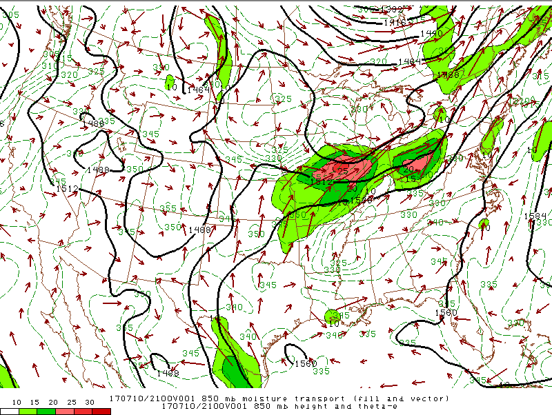
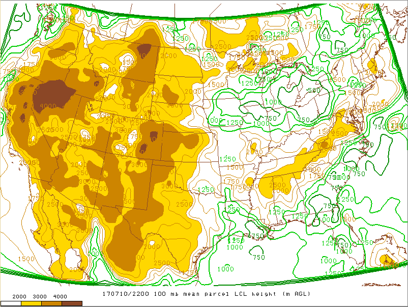
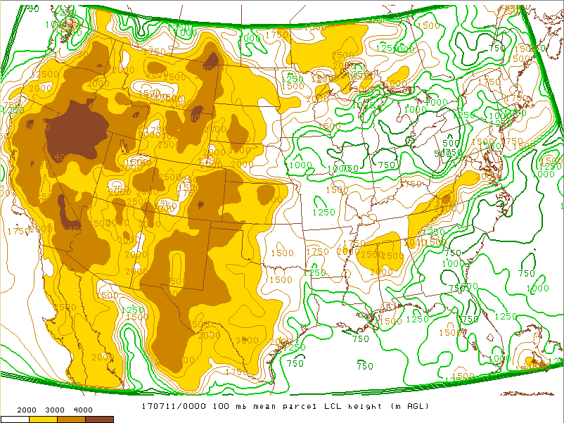
Convectively reinforced baroclinic zone (resulting from outflow/differential heating with clouds over IN and clearing over IL) remained draped from NW to SE across northern IL and north-central IN for the event. Storms moved along this boundary through the evening-tracking E-SE. Strong instability of 2000 J/kg across the S-SW CWA along with 35-45 knots of effective bulk shear led to supercell development. Our area was the focus for 850mb moisture transport-and LCL’s were less than 750 m, PWATS above 1.7”. Given sufficient low level shear of 20-25 knots, tornadoes developed.
Moisture
 |
 |
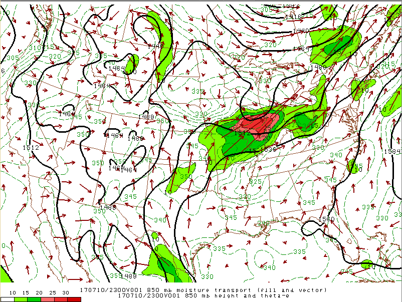 |
| Figure 1: Precipitable Water (in) at 7 pm EDT. Image from SPC | Figure 2: 850mb heights, Moisture Transport Vectors at 5 pm EDT. Image from SPC | Figure 3: 850mb Pressure, Moisture Transport Vectors at 7 pm EDT. Image from SPC |
 |
 |
 |
| Figure 4: LCL Heights (m AGL) at 6 pm EDT. Image from SPC | Figure 5: LCL Heights (m AGL) at 8 pm EDT. Image from SPC | Figure 6: Deep Moisture Convergence at 7 pm EDT. Image from SPC |
Lift (trigger)
 |
 |
 |
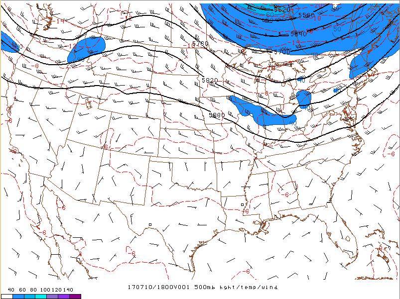
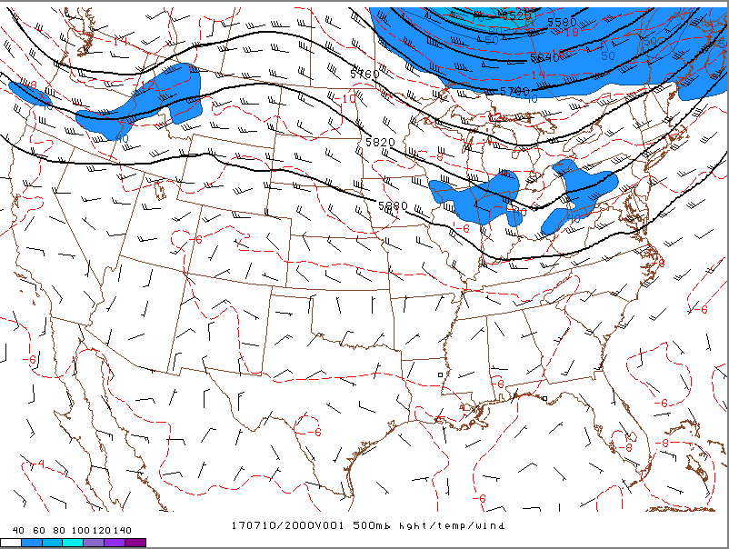
| Figure 7: 500mb Winds, Heights at 2 pm EDT. Image from SPC | Figure 8: 500mb Winds, Heights at 4 pm EDT. Image from SPC | Figure 9: 500mb Winds, Heights at 7 pm EDT. Image from SPC |
 |
 |
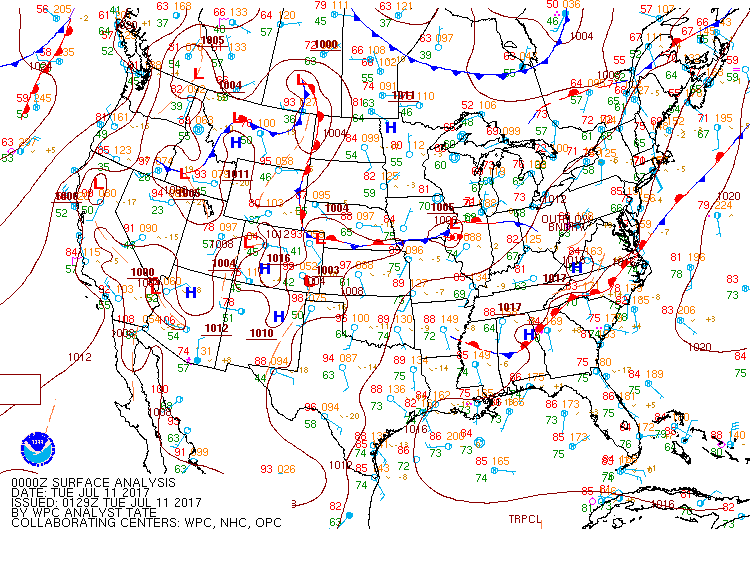 |
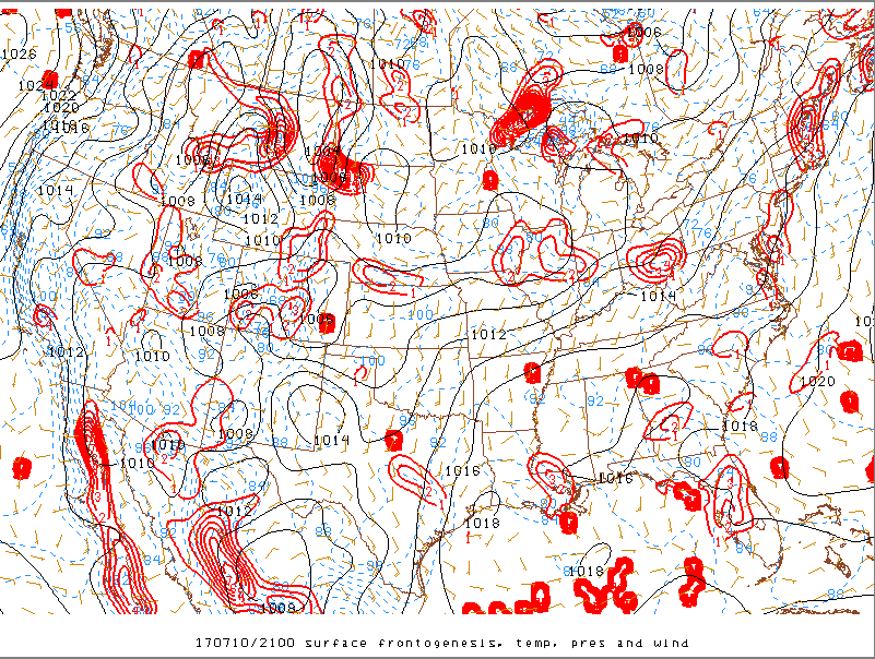
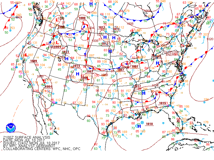
| Figure 10: Surface Frontogenesis at 5 pm EDT. Shows the differential heating boundary that developed to force convection. Image from SPC | Figure 11: Surface Map. Fronts/pressure/obs at 5 pm EDT. | Figure 12: Surface Map. Fronts/pressure/obs at 8 pm EDT. |
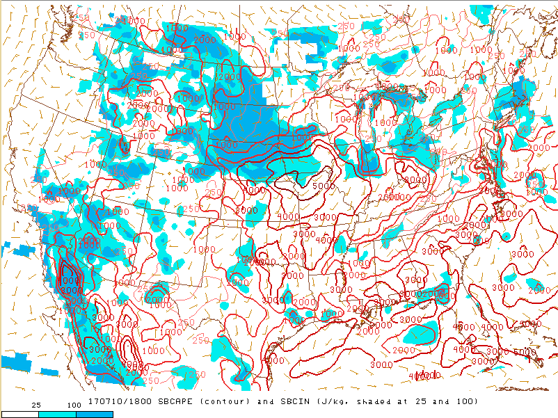
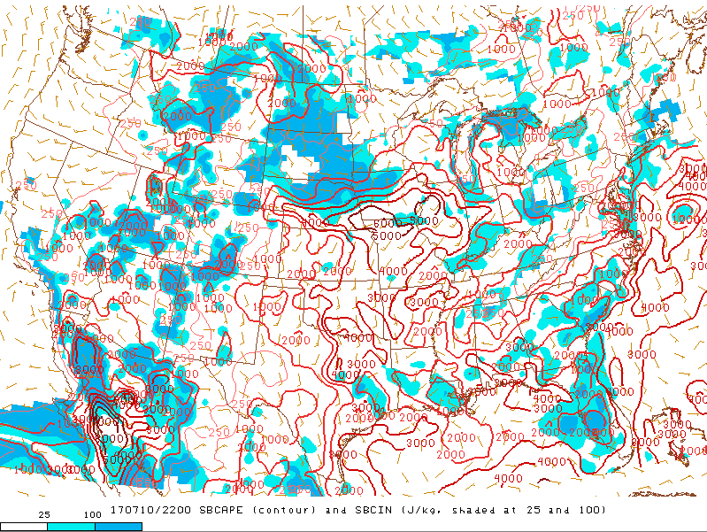
Instability
 |
 |
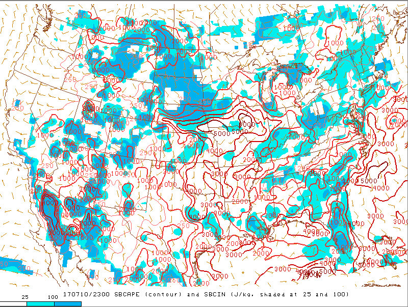 |
| Figure 13: Surface Based CAPE (J/kg) and CIN (Shading) at 2 pm EDT. | Figure 14: Surface Based CAPE (J/kg) and CIN (Shading) at 6 pm EDT. | Figure 15: Surface Based CAPE (J/kg) and CIN (Shading) at 6 pm EDT. |
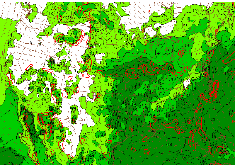
Wind Shear/Tornado Parameter
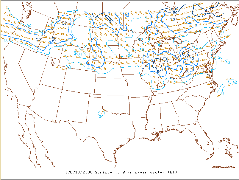 |
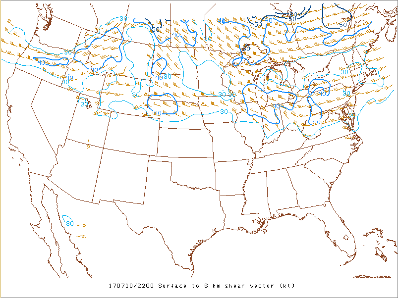 |
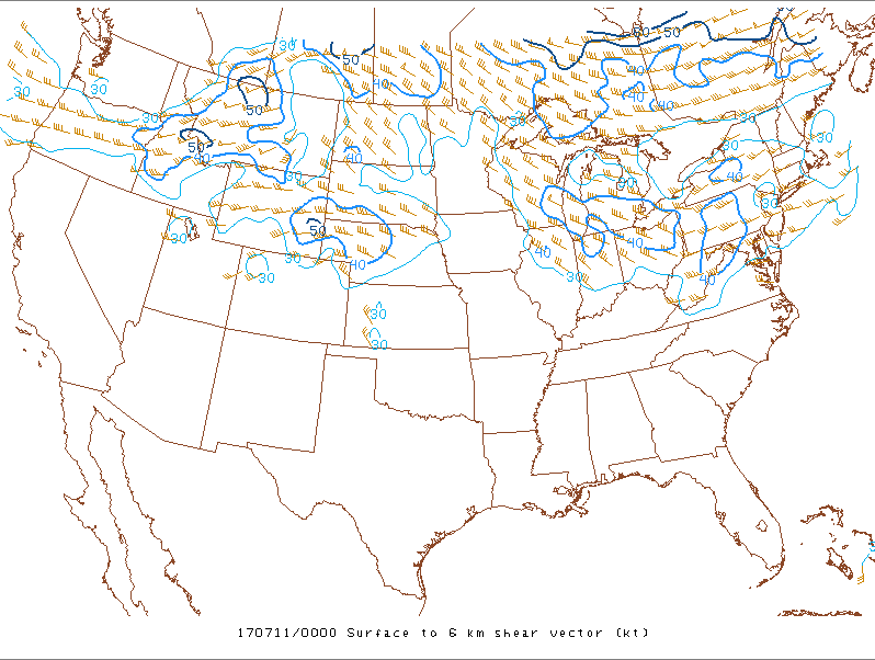 |
| Figure 16: 0-6 km Wind Shear at 5 pm EDT. | Figure 17: 0-6 km Wind Shear at 6 pm EDT. | Figure 18: 0-6 km Wind Shear at 8 pm EDT. |
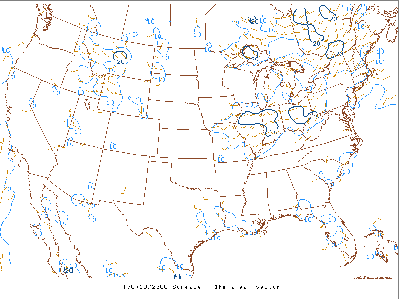 |
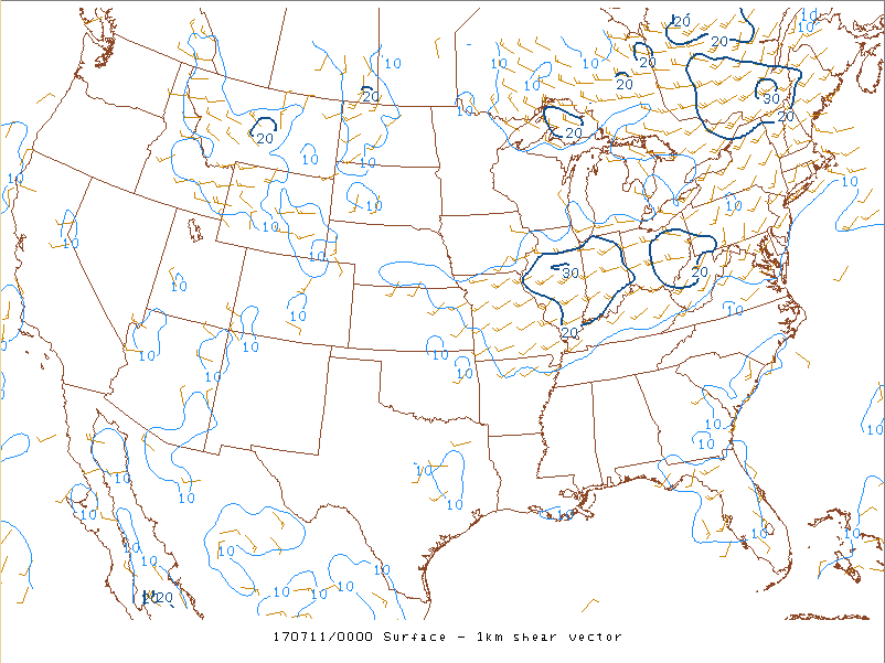 |
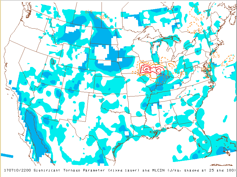 |
| Figure 19: 0-1 km Wind Shear (Low Level) at 6 pm EDT. | Figure 20: 0-1 km Wind Shear (Low Level) at 8 pm EDT. | Figure 21: SigTor Parameter at 6 pm EDT. |
 |
Media use of NWS Web News Stories is encouraged! Please acknowledge the NWS as the source of any news information accessed from this site. |
|

