Overview
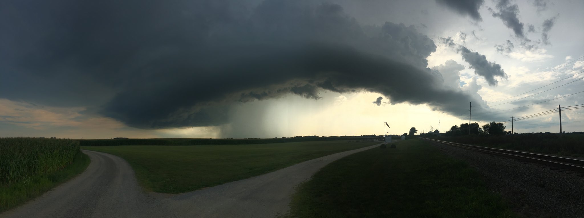
Scattered thunderstorms developed across south central Lower Michigan and extreme northwest Ohio during the late afternoon of August 6th. These storms produced isolated wind damage. Numerous showers and thunderstorms then developed across the remainder of the region during the afternoon and evening hours. These storms produced isolated large hail and isolated wind damage. An NWS storm survey team also concluded an EF-1 tornado occurred in Kosciusko county. In addition to the isolated severe weather, localized flooding was reported.
Tornadoes:
|
Tornado - Warsaw, IN KOSCIUSKO
Track Map 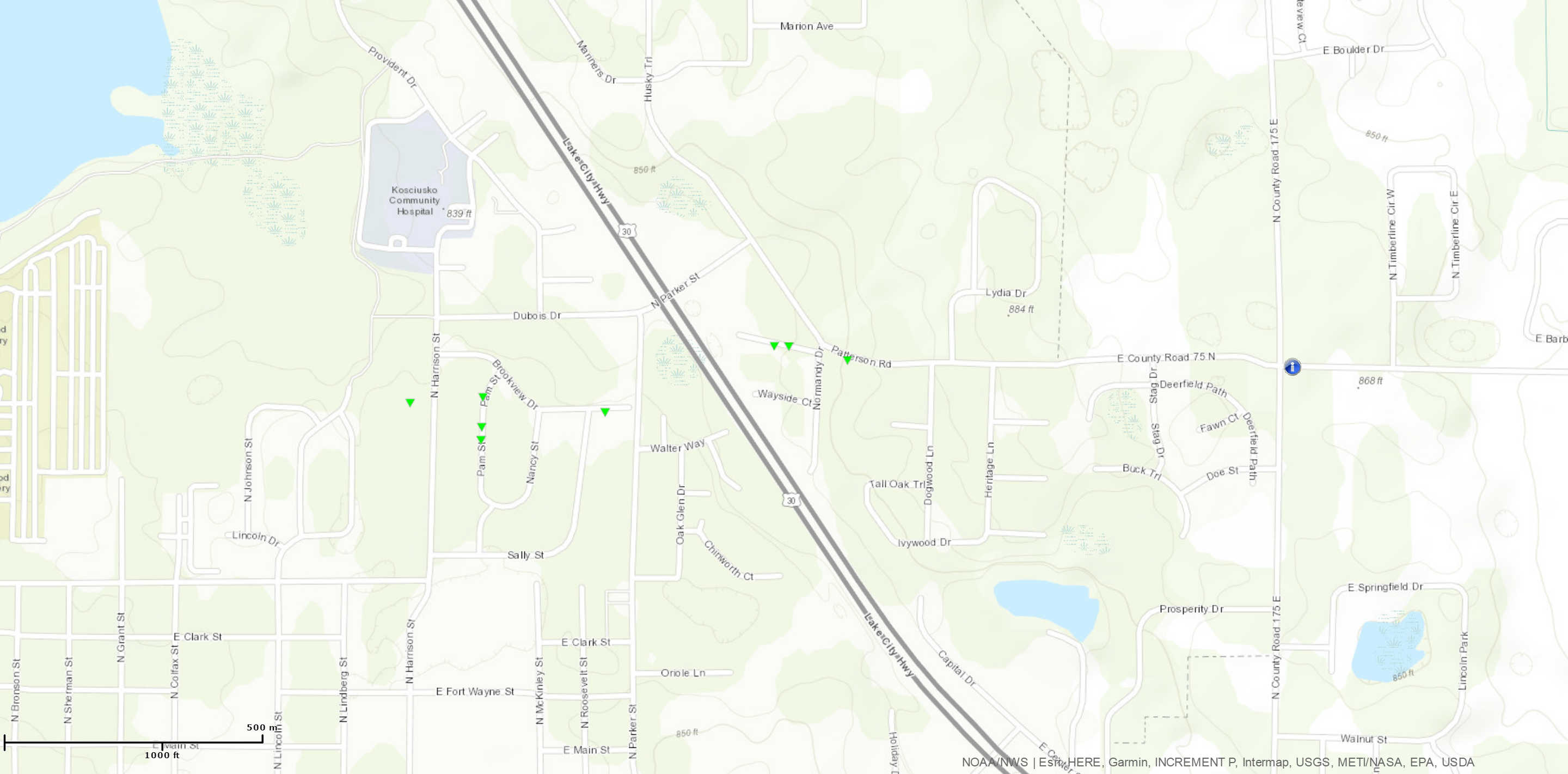 
Downloadable KMZ File |
||||||||||||||||
The Enhanced Fujita (EF) Scale classifies tornadoes into the following categories:
| EF0 Weak 65-85 mph |
EF1 Moderate 86-110 mph |
EF2 Significant 111-135 mph |
EF3 Severe 136-165 mph |
EF4 Extreme 166-200 mph |
EF5 Catastrophic 200+ mph |
 |
|||||
Photos & Video:
 |
 |
 |
 |
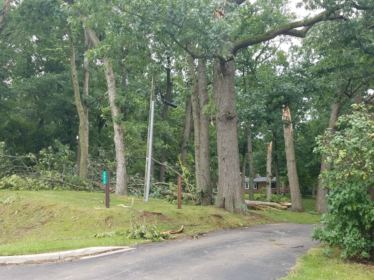
| Tornado damage near the intersection of Patterson Rd. and Normany Dr. in Warsaw, IN. (NWS Northern Indiana) |
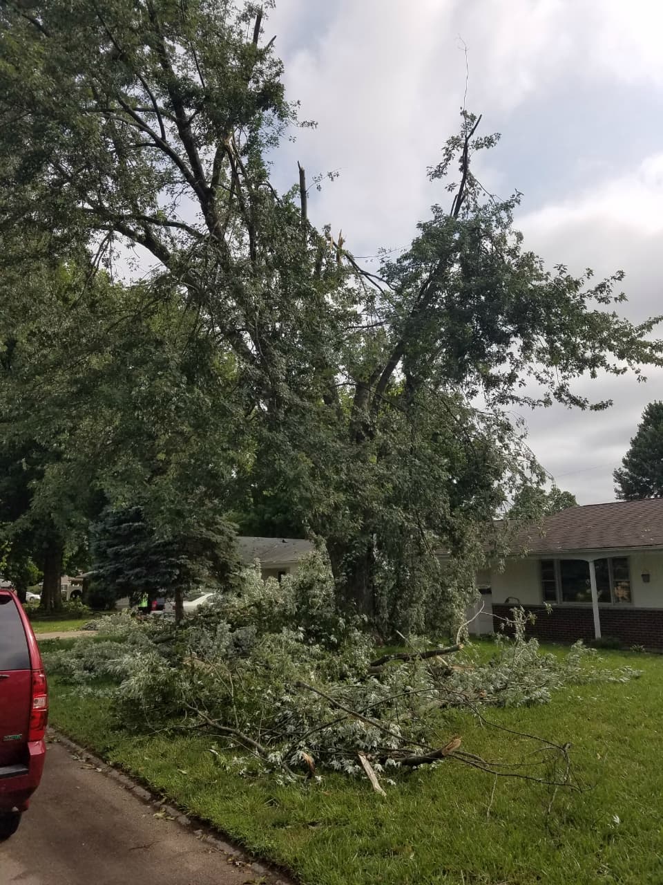
Tornado damage near the intersection of Brookview Dr. and Pam St. in Warsaw, IN. (NWS Northern Indiana) |
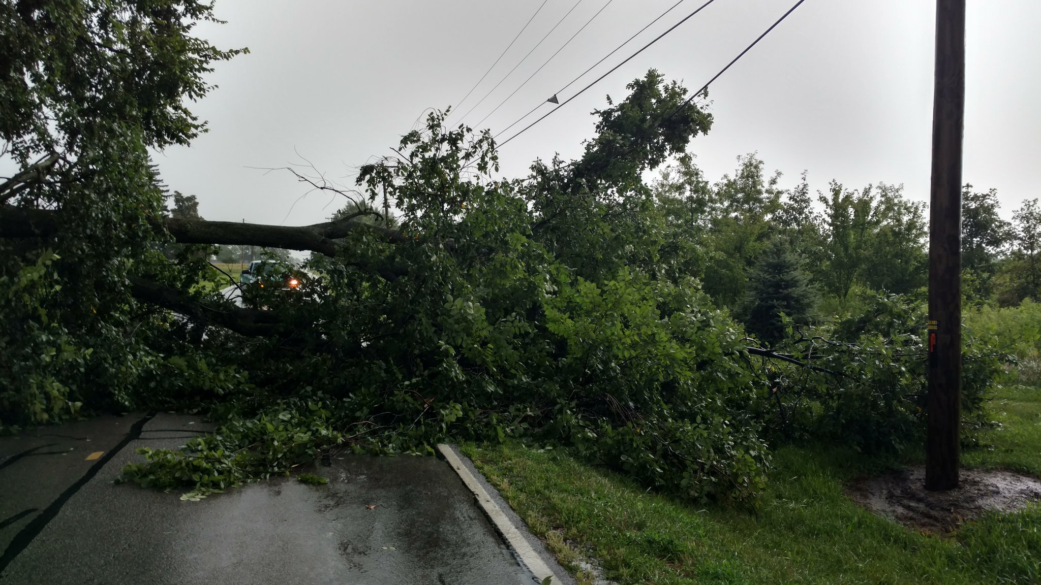
This tree was toppled by a severe storm near County Road J, between 10 and 11 in Fulton County, OH. (Ben Kessler) |
This shelf cloud was observed west of Elida, OH. (Benjamin Rife) |
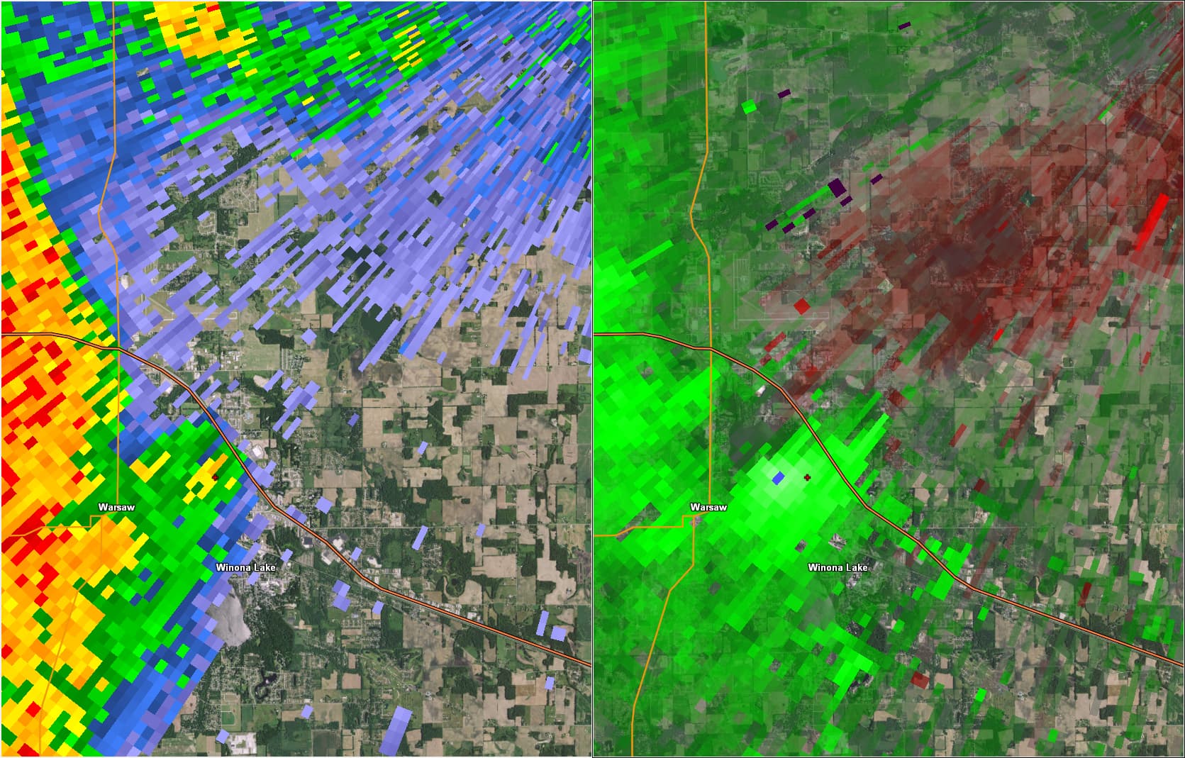
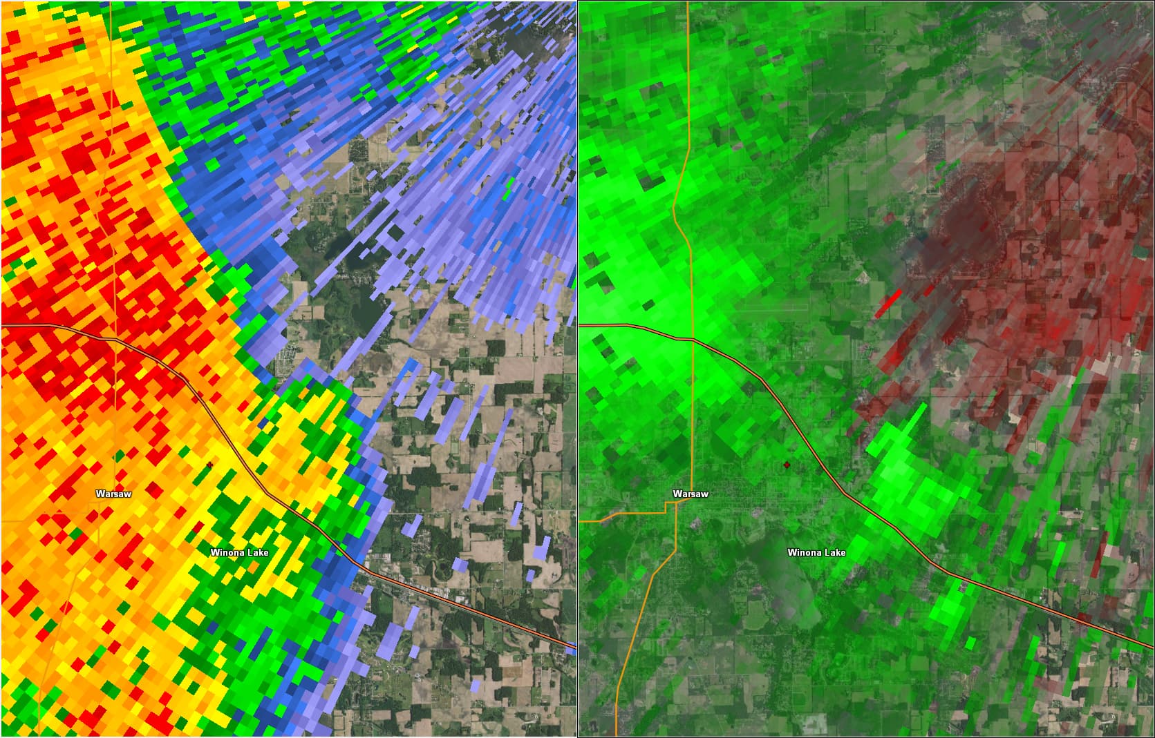
Radar:
The images below show base reflectivity on the left, and storm relative velocity on the right.
 |
 |
 |
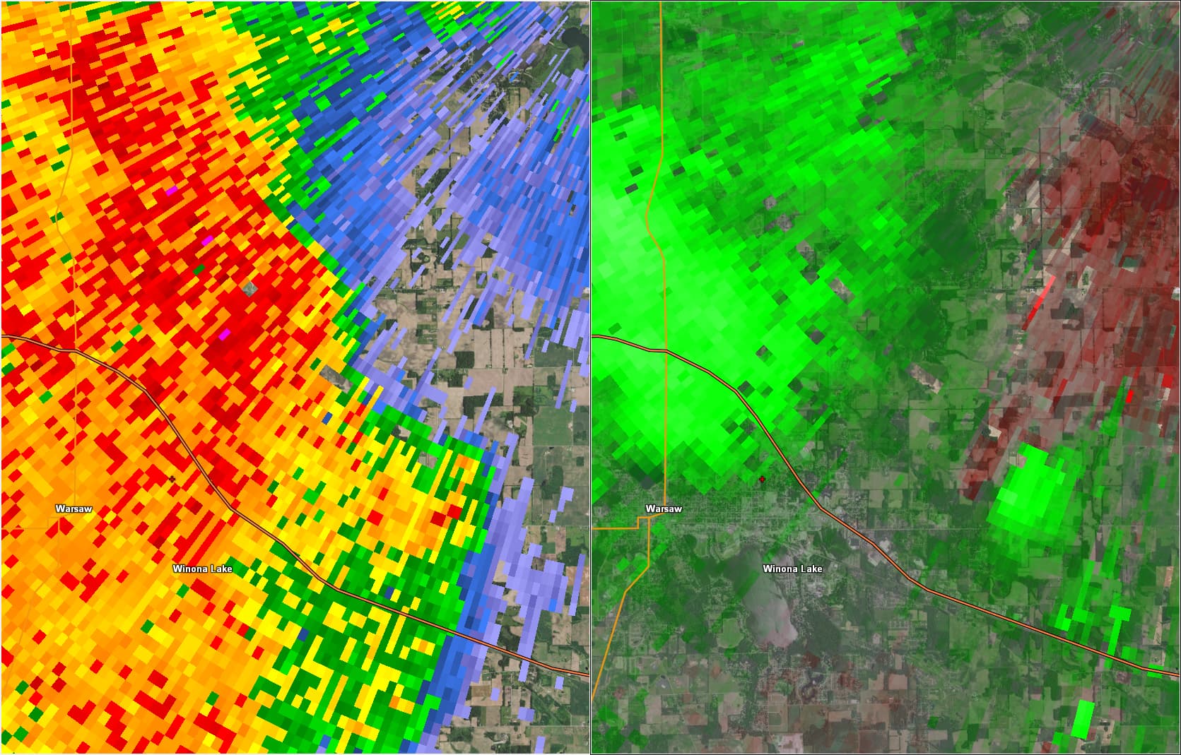 |
| Warsaw Tornado Loop | 8:27 PM EDT: The tornado is believed to have touched down at this time. The small, red, cross north-northeast of Warsaw indicates the approximate starting location of the tornado. | 8:30 PM EDT: The strongest rotation, indicated by the red (outbound) colors touching the green (inbound) colors, is now located south of Little Chapman Lake. | 8:33 PM EDT: The tornado is believed to have ended at 8:34 PM EDT. Weak rotation is still evident south of Little Chapman Lake. |
Storm Reports
PRELIMINARY LOCAL STORM REPORT...SUMMARY
NATIONAL WEATHER SERVICE NORTHERN INDIANA
1220 AM EDT TUE AUG 7 2018

..TIME...   ...EVENT...      ...CITY LOCATION...     ...LAT.LON...
..DATE...   ....MAG....      ..COUNTY LOCATION..ST.. ...SOURCE....
            ..REMARKS..

1030 PM     HEAVY RAIN       BROOKSTON               40.60N 86.87W
08/06/2018  M2.45 INCH       WHITE              IN   TRAINED SPOTTER


0952 PM     TSTM WND DMG     1 NE WATERFORD MILLS    41.55N 85.82W
08/06/2018                   ELKHART            IN   BROADCAST MEDIA

            TREE SPLIT AND FELL.

0905 PM     TSTM WND DMG     COLUMBIA CITY           41.16N 85.49W
08/06/2018                   WHITLEY            IN   EMERGENCY MNGR

            LARGE TREE FELL ON A HOUSE AND TOOK DOWN
            POWER LINES. TIME ESTIMATED FROM RADAR.

0904 PM     HEAVY RAIN       1 N ROSELAND            41.73N 86.25W
08/06/2018  M2.26 INCH       ST. JOSEPH         IN   BROADCAST MEDIA

            FELL IN LESS THAN 1 HR AND A HALF.

0900 PM     TSTM WND DMG     3 S ALVARADO            41.54N 84.84W
08/06/2018                   STEUBEN            IN   EMERGENCY MNGR

            POWER LINES DOWN.

0840 PM     TSTM WND DMG     2 SSE RIDINGER LAKE     41.23N 85.64W
08/06/2018                   WHITLEY            IN   EMERGENCY MNGR

            SEVERAL DOWNED TREES NEAR DENISTON NATURE
            PRESERVE. TIME ESTIMATED FROM RADAR.

0835 PM     TSTM WND DMG     ORLAND                  41.73N 85.17W
08/06/2018                   STEUBEN            IN   EMERGENCY MNGR

            SEVERAL TREE LIMBS DOWN.

0814 PM     TSTM WND GST     2 SW SOUTHWEST          41.52N 85.97W
08/06/2018  M58 MPH          ELKHART            IN   TRAINED SPOTTER

            MEDIUM SIZED LIMB DOWN BLOCKING HALF OF SR
            119 AS WELL.

0746 PM     TSTM WND DMG     1 W ELIDA               40.79N 84.22W
08/06/2018                   ALLEN              OH   BROADCAST MEDIA

            THREE INCH TREE LIMBS DOWN.

0703 PM     TSTM WND DMG     1 NNW GEORGETOWN        41.74N 86.24W
08/06/2018                   ST. JOSEPH         IN   TRAINED SPOTTER

            PENNY SIZED HAIL AND ESTIMATED WIND GUSTS OF
            40 TO 50 MPH.

0656 PM     NON-TSTM WND GST SOUTH BEND INTERNATIONA 41.71N 86.32W
08/06/2018  M60 MPH          ST. JOSEPH         IN   ASOS

            ASOS STATION SBN, SOUTH BEND INTERNATIONAL
            AP.

0655 PM     HEAVY RAIN       3 SSE COLON             41.93N 85.30W
08/06/2018  M2.44 INCH       ST. JOSEPH         MI   COCORAHS

            RAIN FELL IN 5 HOURS.

0622 PM     TSTM WND DMG     OTTOKEE                 41.60N 84.13W
08/06/2018                   FULTON             OH   TRAINED SPOTTER

            LARGE LIMB DOWN.

0602 PM     TSTM WND DMG     1 S COLON               41.94N 85.33W
08/06/2018                   ST. JOSEPH         MI   PUBLIC

            TWO LARGE TREES TIPPED OVER. TIME ESTIMATED
            BY RADAR.

0524 PM     TSTM WND DMG     1 NNW SWANTON           41.60N 83.90W
08/06/2018                   FULTON             OH   TRAINED SPOTTER

            POWER LINE DOWN. TIME ESTIMATED FROM RADAR.

0504 PM     HAIL             2 WNW WINAMEG           41.64N 84.10W
08/06/2018  M1.00 INCH       FULTON             OH   TRAINED SPOTTER


0500 PM     TSTM WND DMG     1 S WINAMEG             41.60N 84.06W
08/06/2018                   FULTON             OH   TRAINED SPOTTER

            TREE DOWN. TIME ESTIMATED BY RADAR.

0433 PM     TSTM WND GST     2 SW FAYETTE            41.66N 84.36W
08/06/2018  E60 MPH          FULTON             OH   TRAINED SPOTTER


0432 PM     TSTM WND DMG     FAYETTE                 41.68N 84.33W
08/06/2018                   FULTON             OH   EMERGENCY MNGR

            TREES AND POWER LINES DOWN IN FAYETTE. TIME
            ESTIMATED FROM RADAR.

0430 PM     TSTM WND DMG     1 NNE FAYETTE           41.68N 84.32W
08/06/2018                   FULTON             OH   EMERGENCY MNGR

            TREE LIMBS DOWN. TIME ESTIMATED BY RADAR.

0430 PM     TSTM WND DMG     1 N FAYETTE             41.68N 84.33W
08/06/2018                   FULTON             OH   EMERGENCY MNGR

            DAMAGE TO SHIPPING CONTAINERS AND TRUCKS.
            TIME ESTIMATED BY RADAR.

0430 PM     TSTM WND DMG     FAYETTE                 41.68N 84.32W
08/06/2018                   FULTON             OH   EMERGENCY MNGR

            TREE LIMBS DOWN. TIME ESTIMATED BY RADAR.
Public Information Statement
National Weather Service Northern Indiana
1134 PM EDT Mon Aug 6 2018

...WIND REPORTS...

Location                     Speed     Time/Date
South Bend International Ap  60 MPH    0656 PM 08/06
2 SW Southwest               58 MPH    0814 PM 08/06
Goshen Municipal Airport     40 MPH    0759 PM 08/06
Defiance Memorial Airport    37 MPH    0657 PM 08/06
Fort Wayne International Ap  36 MPH    1008 PM 08/06
Fulton County Airport        35 MPH    0815 PM 08/06
Fulton Cnty Ap               35 MPH    1025 PM 08/06
1 W Michigan City            34 MPH    0623 PM 08/06
1 WSW Antwerp                34 MPH    0640 PM 08/06
Bridgman Buoy                34 MPH    0740 AM 08/06
Plymouth                     32 MPH    0739 PM 08/06
Warsaw Municipal Airport     32 MPH    0835 PM 08/06
Kalida                       32 MPH    1039 PM 08/06
1 NE Tedrow                  31 MPH    0756 PM 08/06
Tri-lakes                    31 MPH    0902 PM 08/06
Logansport/cass Cnty Ap      31 MPH    1035 PM 08/06
Saint Joseph                 30 MPH    0740 AM 08/06
2 SW Warsaw                  30 MPH    0835 PM 08/06


Observations are collected from a variety of sources with varying
equipment and exposures. We thank all volunteer weather observers
for their dedication. Not all data listed are considered official.
Rain Reports
Public Information Statement
National Weather Service Northern Indiana
1028 PM EDT Mon Aug 6 2018

...RAINFALL REPORTS FROM AUGUST 6TH...

Location                     Amount    Time/Date       Lat/Lon

...Indiana...

...Allen County...
4 N New Haven                1.13 in   1015 PM 08/06   41.13N/85.03W

...Elkhart County...
1 WNW Jimtown                1.31 in   1014 PM 08/06   41.64N/86.04W

...Lagrange County...
1 ENE Lagrange               2.40 in   1010 PM 08/06   41.65N/85.39W

...St. Joseph County...
1 NW South Bend              2.40 in   1003 PM 08/06   41.69N/86.29W
1 N Roseland                 2.26 in   0904 PM 08/06   41.73N/86.25W
South Bend International Ap  1.94 in   0754 PM 08/06   41.71N/86.32W
2 ESE Mishawaka              1.08 in   0953 PM 08/06   41.65N/86.13W

...Starke County...
3 N Brems                    1.27 in   1000 PM 08/06   41.39N/86.71W

...Steuben County...
1 SE Crooked Lake            1.60 in   1003 PM 08/06   41.66N/85.02W
2 W Silver Lake              1.15 in   0915 PM 08/06   41.63N/85.11W
Angola                       1.03 in   1025 PM 08/06   41.64N/85.00W

...White County...
Monticello                   2.56 in   1003 PM 08/06   40.74N/86.77W
1 WNW Indiana Beach          1.78 in   1005 PM 08/06   40.80N/86.79W

...Michigan...

...Cass County...
2 NW Granger                 1.35 in   1006 PM 08/06   41.77N/86.17W

...Hillsdale County...
Litchfield                   1.04 in   1003 PM 08/06   42.05N/84.75W

...St. Joseph County...
3 SSE Colon                  2.44 in   0655 PM 08/06   41.93N/85.30W

...Ohio...

...Fulton County...
1 NE Tedrow                  1.65 in   1006 PM 08/06   41.62N/84.19W

Observations are collected from a variety of sources with varying
equipment and exposures. We thank all volunteer weather observers
Environment
 |
 |
 |
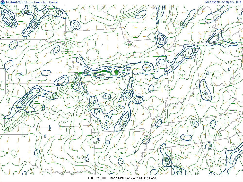 |
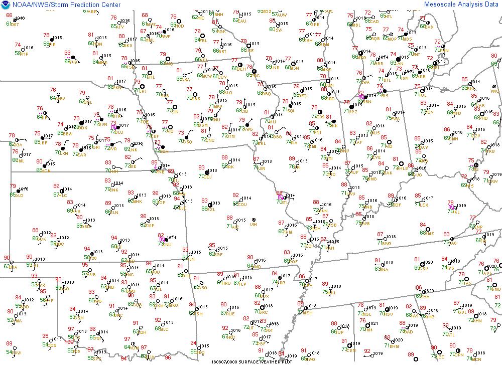
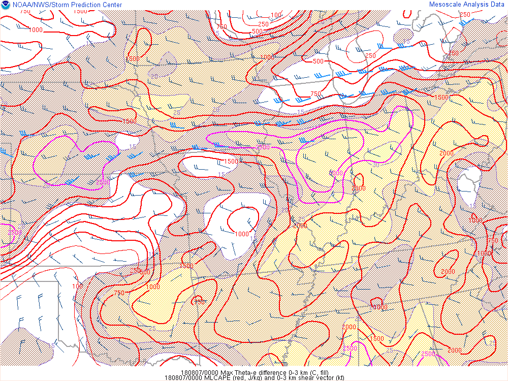
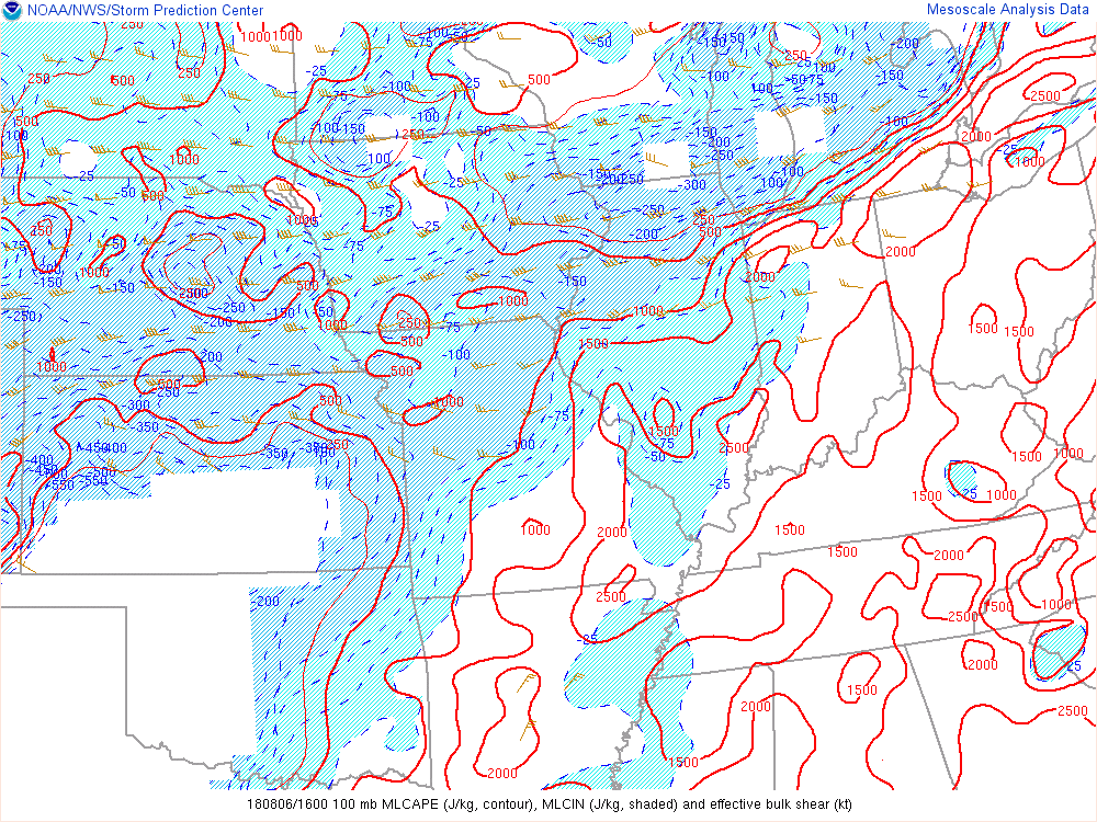
| Figure 1: SFC Map valid 00Z 08/07/18 | Figure 2: 0-3km Max Theta-e difference (C, fill)/100 mb MLCAPE (red, j/kg) and 0-3km shear vector (kt) valid 00Z 08/07/18 | Figure 3: 100 mb MLCAPE (J/kg, contour), MLCIN (J/kg, shaded) and effective bulk shear (kt) valid 00Z 08/07/18 | Figure 4: SFC Moisture Convergence (blue, contour)/Mixing Ratio (green, contour) valid 00Z 08/07/18/ |
 |
Media use of NWS Web News Stories is encouraged! Please acknowledge the NWS as the source of any news information accessed from this site. |
|

