Overview
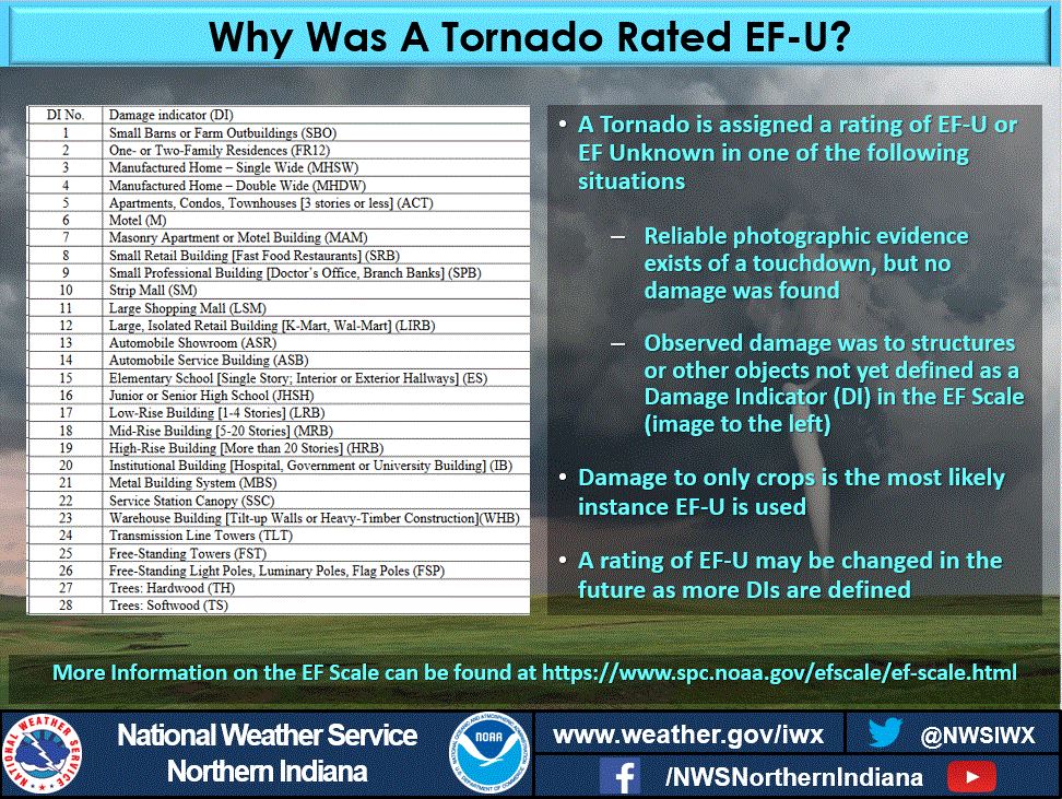
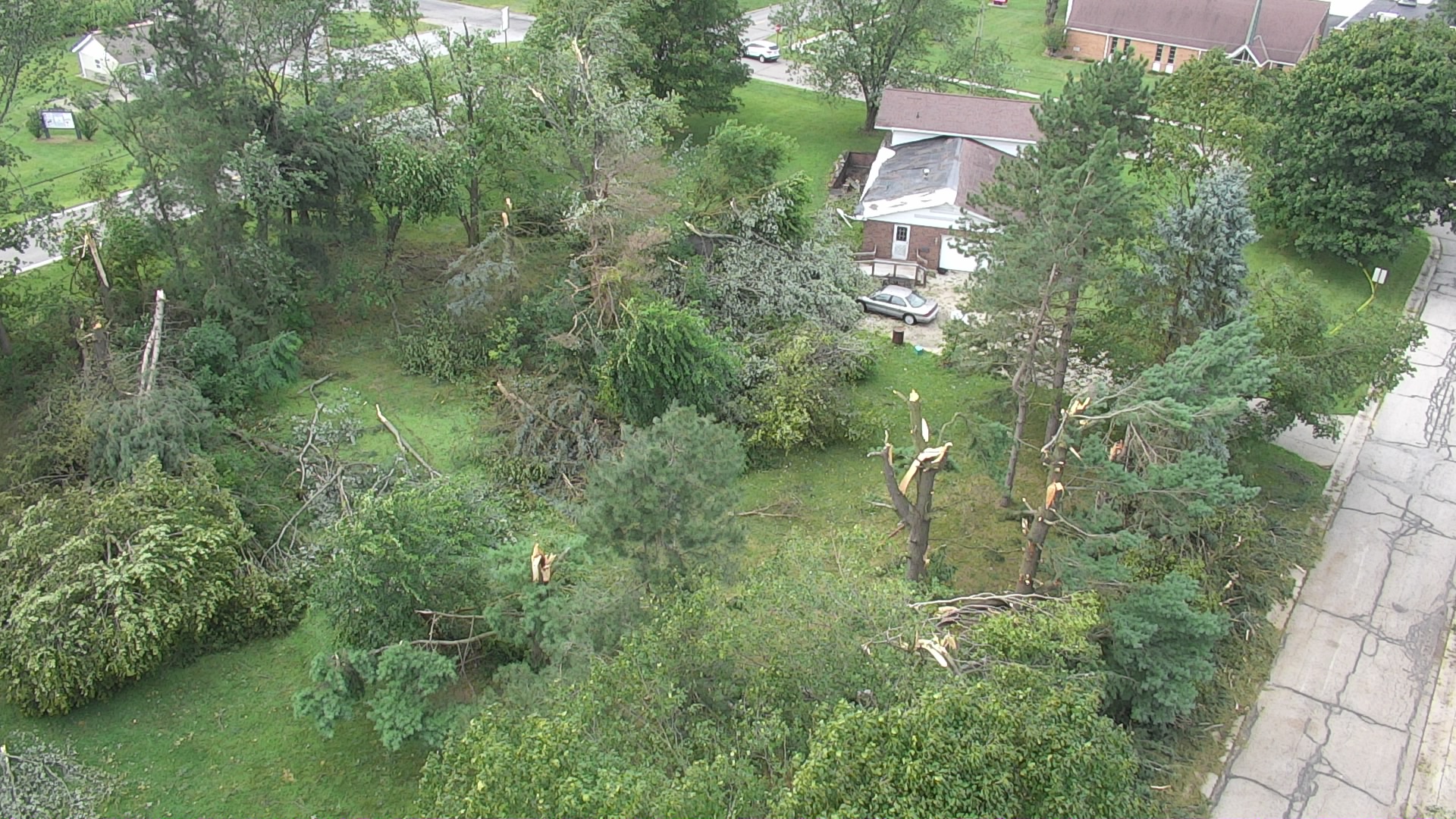
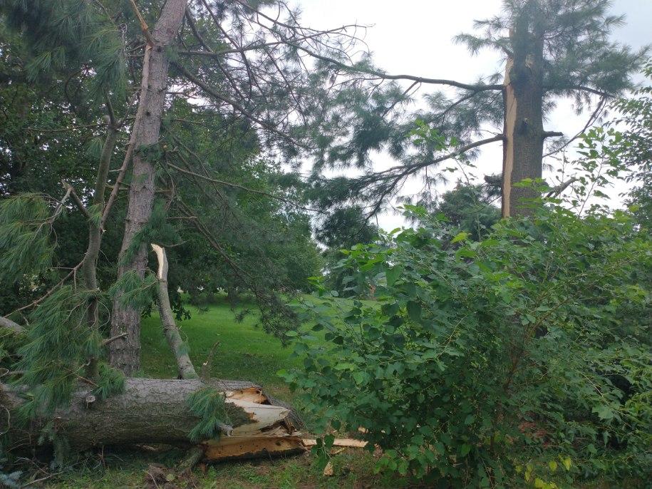
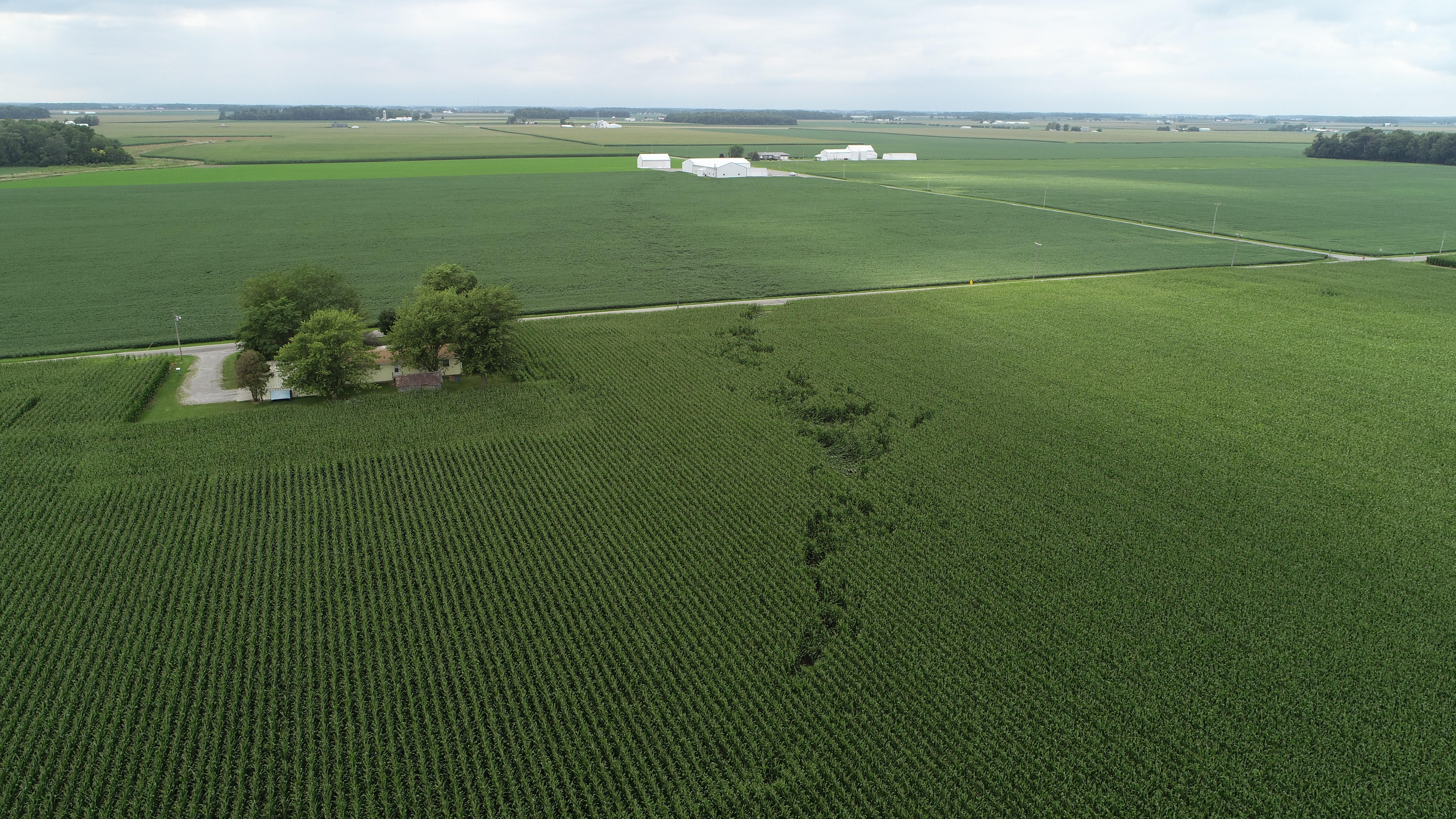
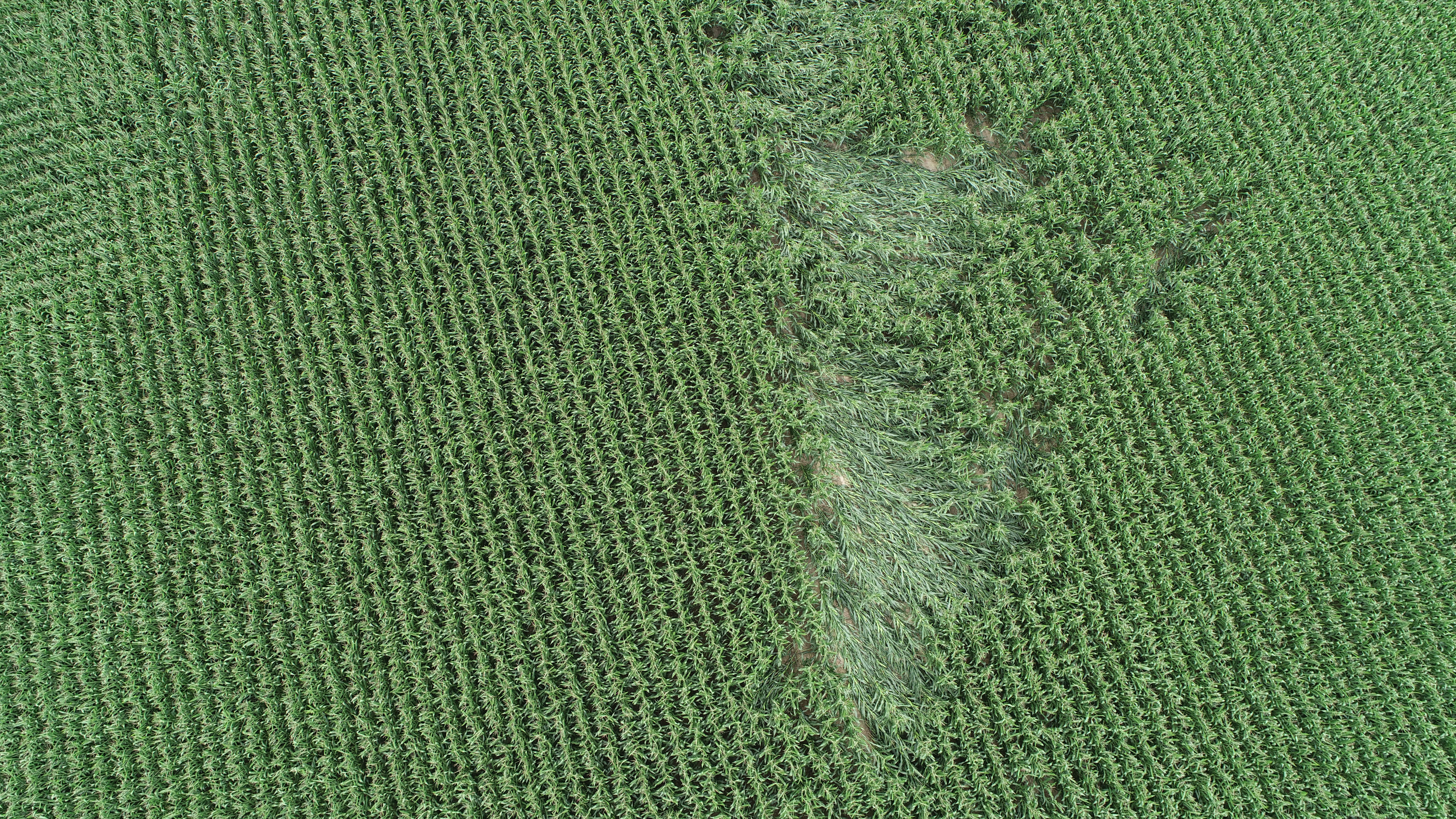
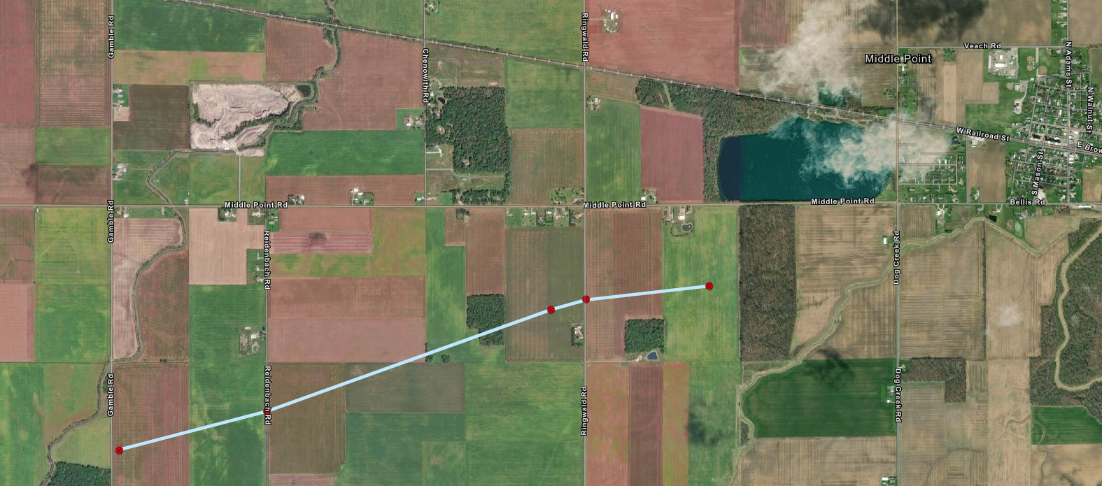
A line of severe storms moved through the Northern Indiana County Warning Area (CWA, Map here) during the afternoon hours on August 11th, 2021, causing widespread straight-line wind damage. Most of the measured and estimated wind gusts ranged from about 50 to 70 mph, but there were pockets of more intense gusts up to 75 mph in Elkhart County, IN (estimated via damage survey in Elkhart/Simonton Lake area) and near Hicksville, OH (measured 73 mph gust). Additionally, we were able to confirm three tornadoes that were embedded within the straight line winds along the main line of storms in northwest Ohio (specifically Van Wert, Allen, and Fulton Counties). The Fulton County tornado in Fayette, OH was rated as an EF-1 with maximum wind speeds of 85 to 90 mph. The tornado that went through both Van Wert and Allen Counties between Venedocia, OH and Southworth, OH, in addition to the tornado two miles west-southwest of Middlepoint, OH were rated as "EF-U", which means the tornado did not cause damage to any qualified damage indicators like trees or structures (it was only crop damage). Unfortunately, in these situations we cannot rate the tornado or provide estimated wind speeds. Thank you to the spotters who submitted photos and reports of wind speeds and damage, in addition to the key eyewitness testimony to the storms. Thank you to our partners at the various EMA offices across the forecast area for sending drone footage and photos, coordinating survey efforts, and gathering input from the community members who saw tornadoes or had damage. Special thanks to the Fulton County, OH Sheriff's office for providing key drone footage in the Fayette Tornado survey. Unfortunately, our phone system went down on August 11th and as of August 14th, 2021 was still out of service (ironically due to storms). As a result, many of our spotters and partners trying to call us reported getting a busy signal (click here for alternative ways to contact us in the meantime). We apologize for any inconvenience this may have caused. A Public Information Statement for the entire event is here (and on the storm reports tab). Click the tabs below to view the event in greater detail.
Tornadoes:
|
Tornado - Fayette, OH
|
||||||||||||||||||||||||
|
||||||||||||||||||||||||
|
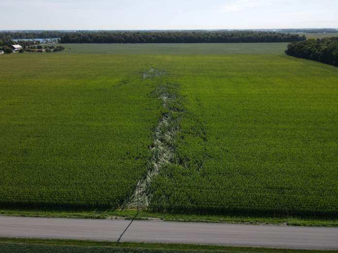
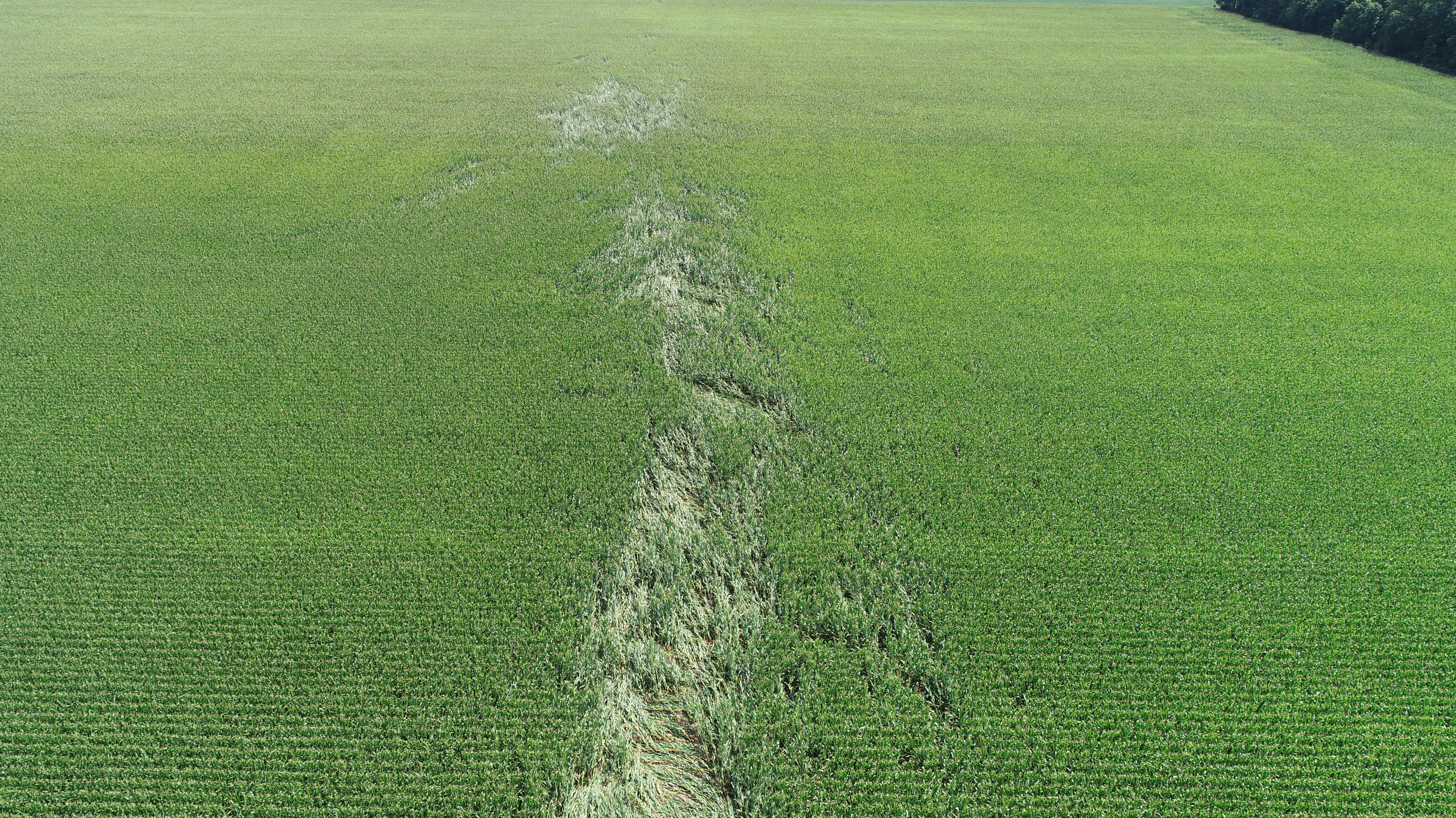
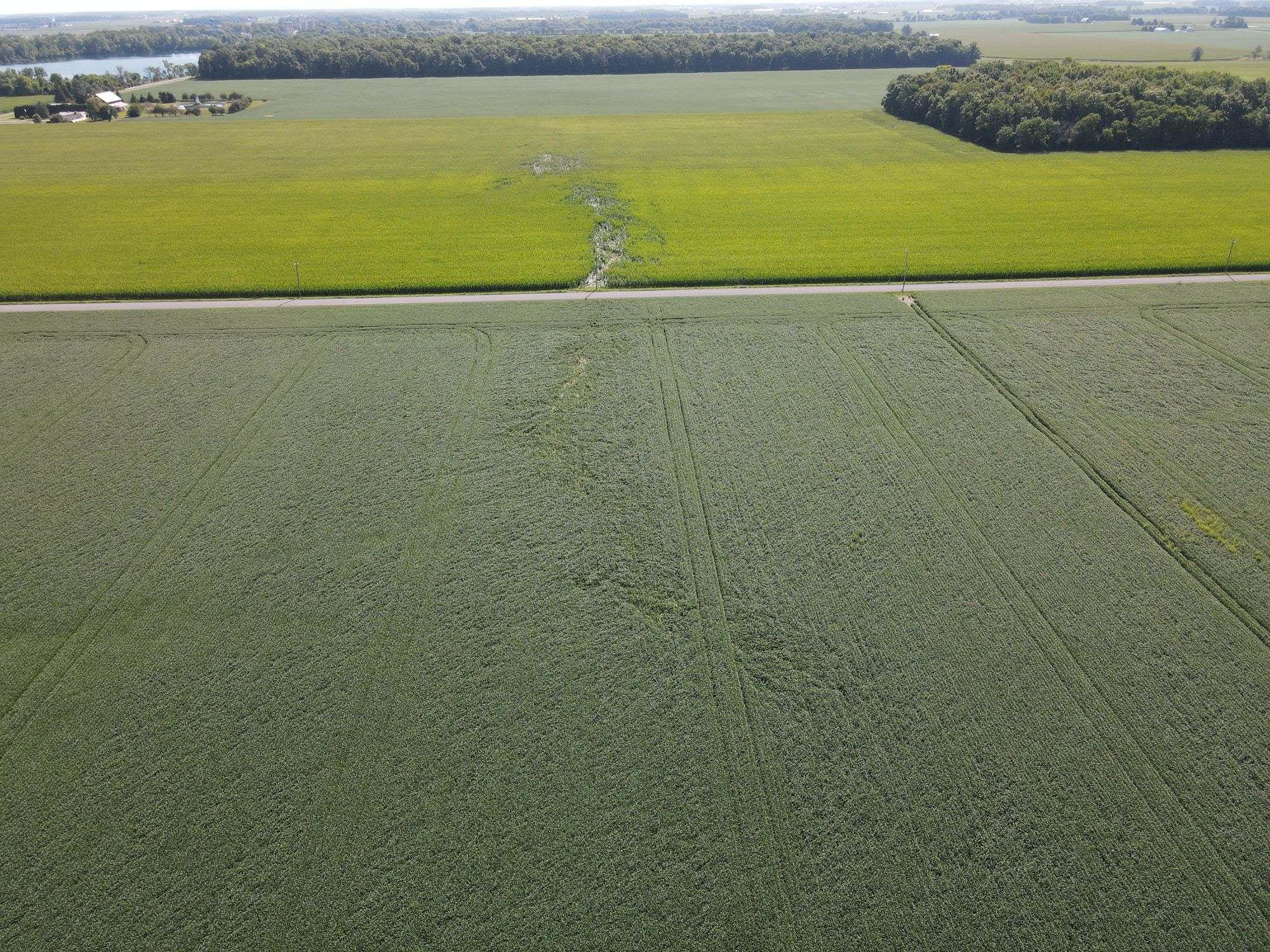
Tornado - Venedocia/Southworth, OH
|
||||||||||||||||||||||||||||||||||||||||||
|
||||||||||||||||||||||||||||||||||||||||||
The Enhanced Fujita (EF) Scale classifies tornadoes into the following categories:
| EF0 Weak 65-85 mph |
EF1 Moderate 86-110 mph |
EF2 Significant 111-135 mph |
EF3 Severe 136-165 mph |
EF4 Extreme 166-200 mph |
EF5 Catastrophic 200+ mph |
 |
|||||
Photos
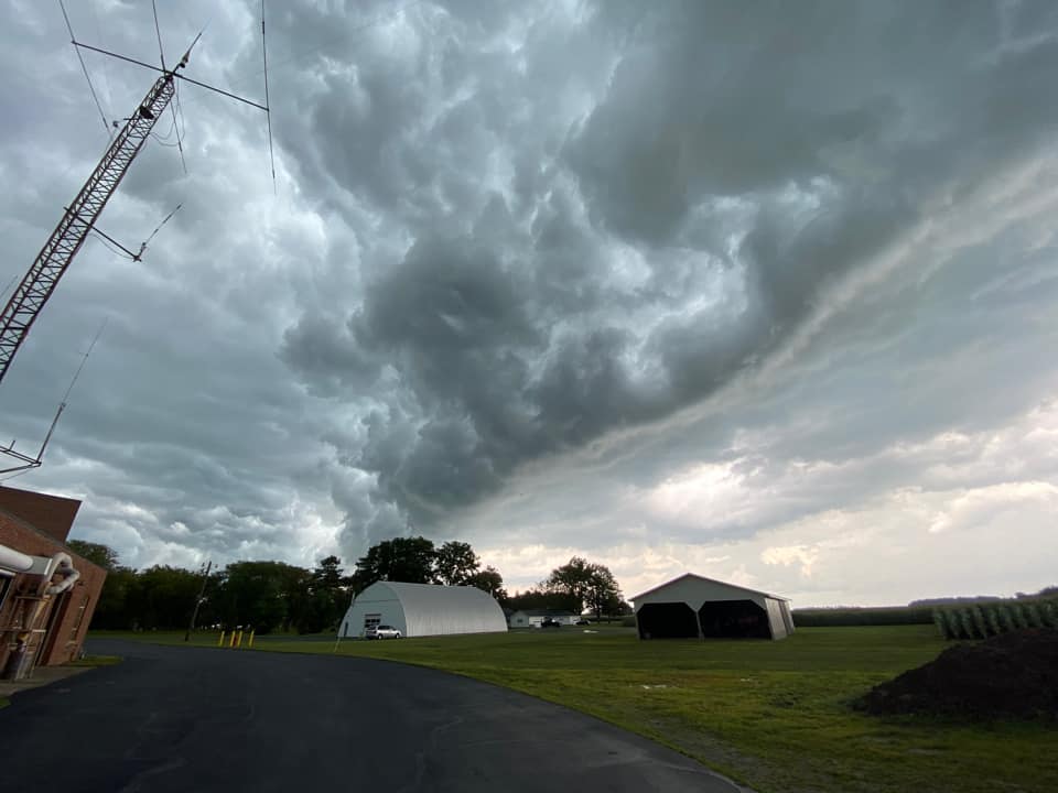
Straight-line wind damage and storm photos from the August 11th, 2021 event are below. Thank you to everyone who sent them to us! If you have pictures of damage or storms that you want us to see, send it to our email account (nws.northernindiana@noaa.gov) or post it on our Twitter (@NWSIWX) or Facebook. Remember to use the TEL method when you submit your report, including the Time, Event, & Location.
 |
 |
 |
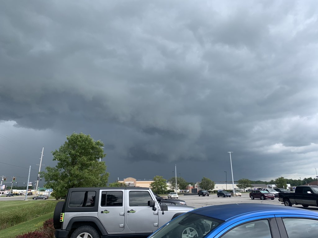
| Figure 1: Shelf Cloud as the storm approached Columbia City, IN (Megan Dodson) | Figure 2: Shelf Cloud Moving over Van Wert, OH (Matt Saunier) | Figure 3: Shelf Cloud as the storm moved over Columbia City, IN (Megan Dodson) |
 |
 |
 |
| Figure 4: Portland, IN (Jay County EMA) | Figure 5: Wind damage from storm in Fort Wayne, IN (Jessica Bowen) | Figure 6: Wind damage in Northeast Elkhart, IN (Lisa Decker) |
 |
 |
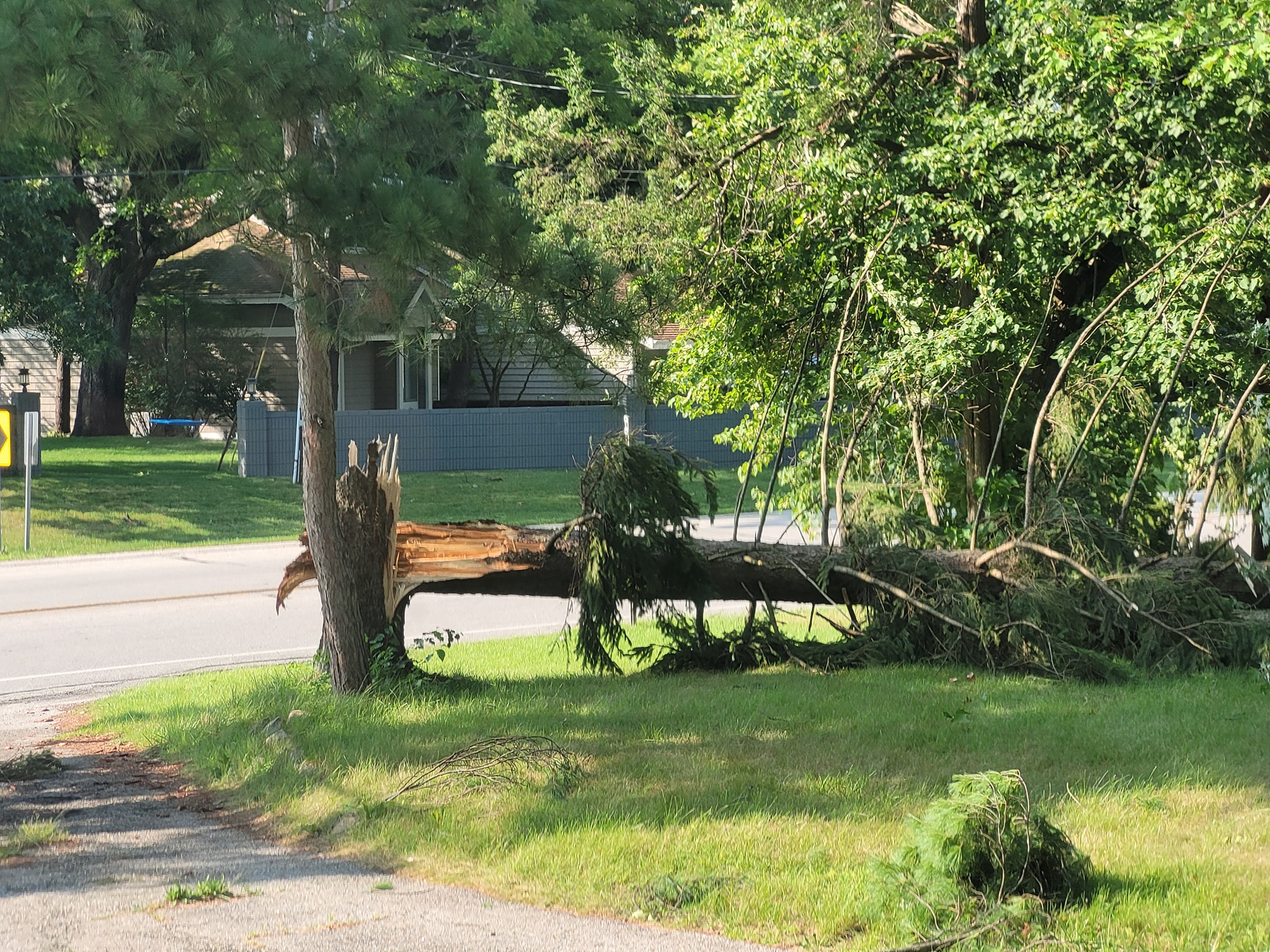 |
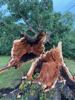
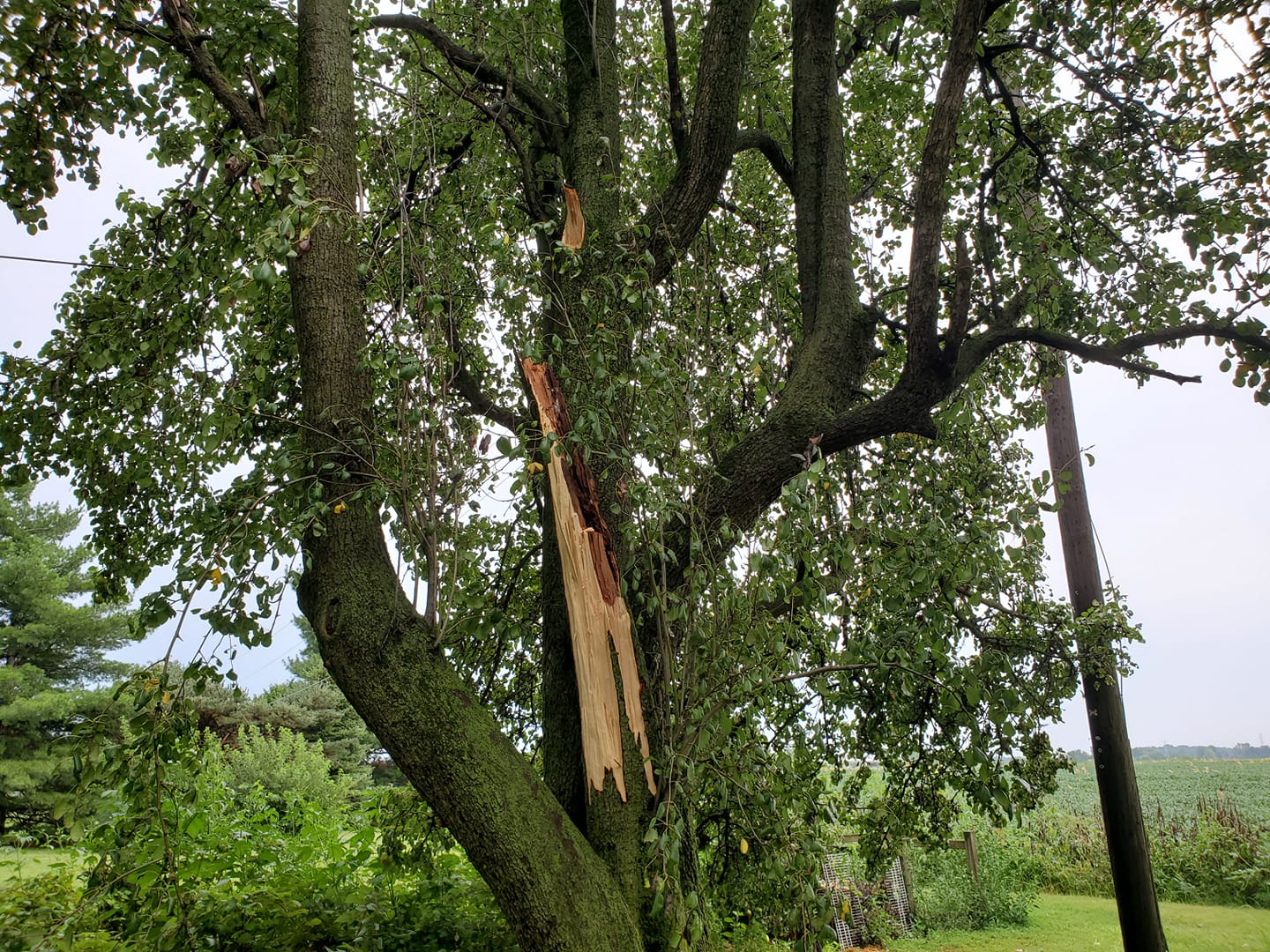
| Figure 7: Oakwood Trailer Park near Portland, IN where winds were estimated to be around 65 mph (Jay County EMA) | Figure 8: Portland, IN High School Bleachers, where winds were estimated to be around 65 mph (Jay County EMA) | Figure 9: Tree snapped in northeast Elkhart, IN (Lisa Decker) |
 |
 |
 |
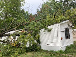
| Figure 10: Tree downed on house in Colon, MI (Tom Talbot) | Figure 11: Metal Roof Blown off a storage building in Colon, MI (Tom Talbot) | Figure 12: Large tree was snapped in Colon, MI (Tom Talbot) |
|
 |
 |
| Figure 13: Large tree limb downed on power lines in Hicksville, OH. Measured a 65 mph wind gust. (Christopher Warner Hicksville Community TV) | Figure 14: Shelf Cloud in Bluffton, IN in Wells Co (Timothy Tessmer) | Figure 15: Some tree damage from Gomer, OH (Rachel Bowerman) |
 |
 |
 |
| Figure 16: Tree snapped 5 mi West of Bourbon, IN (Rae Ramer) | Figure 17: Tree damage 5 mi West of Bourbon, IN (Rae Ramer) | Figure 18: Tree damage 5 mi West of Bourbon, IN (Rae Ramer) |
Radar
A radar loop (created with GR2Analyst) of the storm moving across the NWS Northern Indiana Forecast Area (CWA) on August 11th, 2021. Click on the square on the bottom right of the loop to enlarge the video.
Storm Reports
![]()
NOAA's National Weather Service
NOAA's National Weather Service
NWSChat
NWSChat

NWSChat Home Change Password Documentation/Help Contacts Online Tools NWS Toolbox
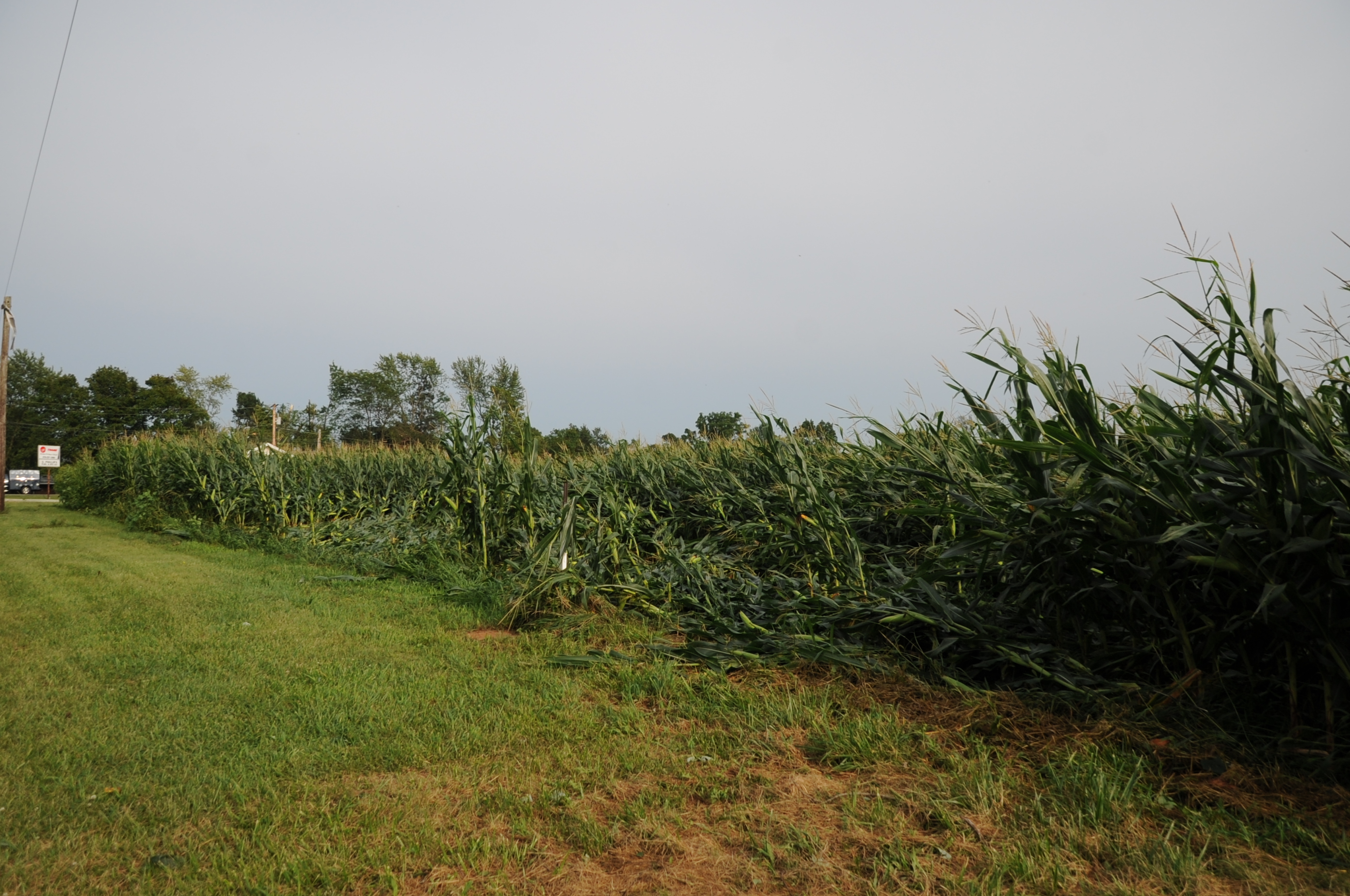
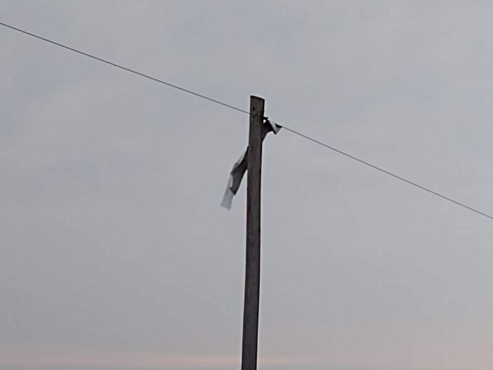
PUBLIC INFORMATION STATEMENT
NATIONAL WEATHER SERVICE NORTHERN INDIANA
741 PM EDT SAT AUG 14 2021 /641 PM CDT SAT AUG 14 2021/

...UPDATED SUMMARY OF STORM DAMAGE OCCURING DURING THE AFTERNOON HOURS OF
AUGUST 11, 2021...

A COMPLEX OF STRONG TO SEVERE STORMS PRODUCED NUMEROUS AREAS OF
WIND DAMAGE ACROSS NORTHERN INDIANA, FAR SOUTHERN LOWER MICHIGAN
AND NORTHWEST OHIO WITH ESTIMATED WIND SPEEDS OF 60 TO 70 MPH.
ELKHART COUNTY APPEARED TO BE THE HARDEST HIT AREA WITH POCKETS OF
MORE EXTENSIVE TREE DAMAGE INDICATING WIND SPEEDS AS HIGH AS 75
MPH IN THE CITIES OF ELKHART AND SIMONTON LAKE. ONE FATALITY
OCCURRED IN THE CITY OF ELKHART AS A RESULT OF A FALLEN TREE ONTO
THE ROAD. IN ADDITION, THREE WEAK TORNADOES OCCURRED WITHIN THE
LARGER WIND DAMAGE AREAS IN NORTHWEST OHIO (FULTON, VAN WERT, AND
ALLEN COUNTIES). SPECIFIC DETAILS AND HIGHLIGHTS OF DAMAGE IN SOME
LOCATIONS CAN BE FOUND BELOW.

.TORNADO 1: FAYETTE, OHIO

RATING:                 EF1
ESTIMATED PEAK WIND:    90 MPH
PATH LENGTH /STATUTE/:  0.22 MILES
PATH WIDTH /MAXIMUM/:   70.0 YARDS
FATALITIES:             0
INJURIES:               0

START DATE:             08/11/2021
START TIME:             02:40 PM EDT
START LOCATION:         FAYETTE / FULTON COUNTY / OH
START LAT/LON:          41.6664 / -84.3284

END DATE:               08/11/2021
END TIME:               02:42 PM EDT
END LOCATION:           1 SSE FAYETTE / FULTON COUNTY / OH
END LAT/LON:            41.6651 / -84.3248

SURVEY SUMMARY:
MAXIMUM SUSTAINED WINDS OF 85 TO 90 MPH. MOST OF THE DAMAGE SURVEYED
WAS CONSISTENT WITH AN EF0 TORNADO, BUT THERE WAS A SMALL AREA OF EF1
DAMAGE IN THE MIDDLE OF THE TRACK NEAR THE INTERSECTION OF S. FAYETTE
STREET AND COUNTY ROAD R. THE EF1 DAMAGE INCLUDED SEVERAL LARGE AND
HEALTHY TREE TRUNKS UP TO 2 FEET IN DIAMETER SNAPPED IN HALF. A LARGE
BRANCH APPROXIMATELY 10 FEET IN LENGTH AND 1 FOOT DIAMETER WAS LOFTED
AROUND 15 YARDS INTO THE SIDE OF A HOUSE AND CAUSED CONSIDERABLE
DAMAGE TO A BALCONY. SHEET METAL ROOFING WAS ALSO LOFTED OVER 200 YARDS
AND CAUSED ROOF DAMAGE TO FAYETTE SCHOOL.

.TORNADO 2: VAN WERT INTO ALLEN COUNTY

RATING:                 EF-U
ESTIMATED PEAK WIND:    UNKNOWN
PATH LENGTH /STATUTE/:  4.7 MILES
PATH WIDTH /MAXIMUM/:   50.0 YARDS
FATALITIES:             0
INJURIES:               0

START DATE:             08/11/2021
START TIME:             03:00 PM EDT
START LOCATION:         2 E VENEDOCIA / VAN WERT COUNTY / OH
START LAT/LON:          40.7749 / -84.4121

END DATE:               08/11/2021
END TIME:               03:09 PM EDT
END LOCATION:           1 ENE SOUTHWORTH / ALLEN COUNTY / OH
END LAT/LON:            40.766 / -84.3239

SURVEY SUMMARY:
EF-U TORNADO TRACK THROUGH FIELDS. SURVEYED WITH DRONE BY RICK
MCCOY,VAN WERT COUNTY EMA. 4.7 MILE LENGTH, MAXIMUM WIDTH 50 YARDS.

THE TORNADO TOUCHED DOWN IN VAN WERT COUNTY IN A CORN FIELD ON THE
NORTHEAST SIDE OF GRIFFIN ROAD, JUST NORTHEAST OF SR 116 AND
CONVERSE-ROSELM RD. THE TORNADO TRACKED JUST SOUTH OF DUE EAST
THROUGH OPEN FIELDS. THE TORNADO TRACKED INTO ALLEN COUNTY OHIO AND
CROSSED SOUTHWORTH ROAD JUST NORTH OF ZION CHURCH ROAD AND TRAVELED
THROUGH SEVERAL FIELDS FOR AN ADDITIONAL 0.3 MILES BEFORE LIFTING.

THIS TORNADO IS CLASSIFIED AS UNKNOWN ON THE EF-SCALE AS THE TORNADO
DID NOT DAMAGE ANY STRUCTURES OR TREES, BUT DID DAMAGE CROPLANDS.

.TORNADO 3 WEST-SOUTHWEST OF MIDDLE POINT IN VAN WERT, OH

RATING:                 EF-U
ESTIMATED PEAK WIND:    UNKNOWN MPH
PATH LENGTH /STATUTE/:  0.5 MILES
PATH WIDTH /MAXIMUM/:   30.0 YARDS
FATALITIES:             0
INJURIES:               0

START DATE:             08/11/2021
START TIME:             02:50 PM EDT
START LOCATION:         2 WSW MIDDLE POINT / VAN WERT COUNTY / OH
START LAT/LON:          40.8482 / -84.4776

END DATE:               08/11/2021
END TIME:               02:52 PM EDT
END LOCATION:           1 WSW MIDDLE POINT / VAN WERT COUNTY / OH
END LAT/LON:            40.8481 / -84.4681

SURVEY SUMMARY:
EF-U TORNADO TRACK THROUGH FIELDS. SURVEYED WITH DRONE BY RICK
MCCOY,VAN WERT COUNTY EMA. 0.5 MILES LENGTH, MAXIMUM WIDTH 30 YARDS.

THE TORNADO TOUCHED DOWN APPROXIMATELY 2 MILES WEST-SOUTHWEST OF
MIDDLE POINT, OHIO. THE TORNADO TRACKED EAST FOR 0.5 MILES BEFORE
LIFTING.

THIS TORNADO IS CLASSIFIED AS UNKNOWN ON THE EF-SCALE AS THE TORNADO
DID NOT DAMAGE ANY STRUCTURES OR TREES, BUT DID DAMAGE CROPLANDS.

.SUMMARY OF WIND DAMAGE

...ELKHART COUNTY, IN...

SEVERAL AREAS OF TREE AND POWER LINE DAMAGE OCCURRED WITH MANY TREES
EITHER UPROOTED OR BROKEN OFF JUST ABOVE GROUND LEVEL. THE AREAS OF
TREE DAMAGE INCLUDED JUST WEST OF DOWNTOWN ELKHART AS WELL AS JUST
WEST OF THE ELKHART AIRPORT. THE HARDEST HIT AREAS WERE NOTED AROUND
THE SIMONTON LAKE AREA WHERE TREES WERE MOSTLY UPROOTED. ADDITIONAL
AREAS OF TREE AND POWER LINE DAMAGE OCCURRED SOUTHEAST OF THE
ELKHART AIRPORT.  WIND SPEEDS IN SOME AREAS WERE ESTIMATED AS HIGH
AS 75 MPH.

A FATAL ACCIDENT OCCURRED WHEN A MOTORCYCLIST TRAVELING ON HENKE
STREET IN ELKHART STRUCK A TREE THAT HAD FALLEN ONTO THE ROADWAY.

...JAY COUNTY, IN...

MULTIPLE LARGE TREES AND TREE LIMBS WERE REPORTED DOWN IN AND AROUND
PORTLAND. PORTABLE BLEACHERS WERE MOVED OR BLOWN OVER AT THE
PORTLAND HIGH SCHOOL. THE REPORTED DAMAGE IS CONSISTENT WITH
STRAIGHT LINE WINDS OF 60 TO 70 MPH. THE PORTLAND MUNICIPAL
AIRPORT RECORDED A 67 MPH WIND GUST DURING THE THUNDERSTORMS.

&&

EF SCALE: THE ENHANCED FUJITA SCALE CLASSIFIES TORNADOES INTO THE
FOLLOWING CATEGORIES:

EF0...WEAK......65 TO 85 MPH
EF1...WEAK......86 TO 110 MPH
EF2...STRONG....111 TO 135 MPH
EF3...STRONG....136 TO 165 MPH
EF4...VIOLENT...166 TO 200 MPH
EF5...VIOLENT...>200 MPH

NOTE:
THE INFORMATION IN THIS STATEMENT IS PRELIMINARY AND SUBJECT TO
CHANGE PENDING FINAL REVIEW OF THE EVENT AND PUBLICATION IN NWS
STORM DATA.

$$

FISHER/HOLSTEN/MURPHY/DODSON
$$

FISHER
PRELIMINARY LOCAL STORM REPORT...SUMMARY
NATIONAL WEATHER SERVICE NORTHERN INDIANA
1206 AM EDT THU AUG 12 2021
..TIME... ...EVENT... ...CITY LOCATION... ...LAT.LON...
..DATE... ....MAG.... ..COUNTY LOCATION..ST.. ...SOURCE....
..REMARKS..
0329 PM TSTM WND DMG 3 E BELLFOUNTAIN 40.44N 84.80W
08/11/2021 JAY IN EMERGENCY MNGR
TREE DOWN ACROSS STATE LINE ROAD AT 200 S
BETWEEN JAY AND MERCER COUNTIES ON THE
INDIANA SIDE.
0325 PM TSTM WND GST 2 WNW WESTMINSTER 40.70N 84.02W
08/11/2021 M54 MPH ALLEN OH ASOS
ASOS STATION KAOH LIMA.
0322 PM TSTM WND DMG PORTLAND 40.44N 85.02W
08/11/2021 JAY IN EMERGENCY MNGR
MULTIPLE TREES REPORTED DOWN NEAR 200 W AND
SR 67 NEAR JAY COUNTY HIGH SCHOOL. ALSO
MULTIPLE TREES DOWN NEAR 100 N AND US 27
NEAR OAKWOOD TRAILER PARK.
0317 PM TSTM WND DMG MONTPELIER 41.59N 84.61W
08/11/2021 WILLIAMS OH PUBLIC
LARGE BRANCHES DOWN ON A HOUSE AND IN THE
ROAD.
0315 PM TSTM WND GST 1 NNW PORTLAND 40.45N 84.99W
08/11/2021 M67 MPH JAY IN MESONET
MESONET STATION KPLD PORTLAND MUNICIPAL
AIRPORT.
0315 PM TSTM WND DMG 1 N SWANTON 41.60N 83.89W
08/11/2021 FULTON OH AMATEUR RADIO
TREE DOWN ON A HOUSE IN SWANTON OFF OF
BROOKSIDE DRIVE.
0315 PM TSTM WND DMG YODER 40.69N 84.07W
08/11/2021 ALLEN OH EMERGENCY MNGR
TWO TREES AND SEVERAL POWERLINES DOWN.
0312 PM TSTM WND GST 5 SW PORTLAND 40.39N 85.05W
08/11/2021 E45 MPH JAY IN PUBLIC
ESTIMATED 40-45 MPH WIND GUSTS.
0310 PM TSTM WND DMG 2 W PORTLAND 40.43N 85.02W
08/11/2021 JAY IN EMERGENCY MNGR
MULTIPLE TREES BEING REPORTED DOWN IN THE
AREA OF 200 W AND SR 67 NEAR JAY COUNTY HIGH
SCHOOL, IN THE CITY OF PORTLAND AND NORTH OF
PORTLAND 100 N US 27 AT OAKWOOD TRAILER PARK
NO TREE SIZES GIVEN.
0306 PM HEAVY RAIN BRYAN 41.50N 84.72W
08/11/2021 M0.76 INCH WILLIAMS OH PUBLIC
0306 PM TSTM WND DMG 2 NNW SWANTON 41.62N 83.91W
08/11/2021 FULTON OH FIRE DEPT/RESCUE
WIRES DOWN ON SR 64 AT CR K. FULTON
TOWNSHIP.
0306 PM TSTM WND DMG 1 NNW SWANTON 41.60N 83.89W
08/11/2021 FULTON OH FIRE DEPT/RESCUE
WIRES DOWN ON BROOKSIDE DRIVE.
0303 PM TSTM WND DMG 2 SSW LYONS 41.67N 84.09W
08/11/2021 FULTON OH FIRE DEPT/RESCUE
WIRES DOWN ON US 20 ROYALTON TOWNSHIP, OH.
0302 PM TSTM WND GST KALIDA 40.98N 84.20W
08/11/2021 M53 MPH PUTNAM OH MESONET
MESONET STATION DW3681 KALIDA.
0300 PM TSTM WND DMG DELTA 41.58N 84.00W
08/11/2021 FULTON OH FIRE DEPT/RESCUE
WIRES DOWN ON CR 7.
0300 PM TSTM WND DMG GOMER 40.84N 84.19W
08/11/2021 ALLEN OH PUBLIC
DELAYED REPORT. SEVERAL 1 TO 2 FT DIAMETER
LIMBS DOWNED, A FEW LARGER TREES OF 2 TO 3
FEET IN DIAMETER DOWNED. TREES APPEARED
HEALTHY IN PHOTOS.
0259 PM TSTM WND GST JEWELL 41.33N 84.29W
08/11/2021 E40 MPH DEFIANCE OH PUBLIC
40 MPH WINDS SUSTAINED.
0257 PM TSTM WND GST HOAGLAND 40.95N 85.00W
08/11/2021 M40 MPH ALLEN IN PUBLIC
40 MPH SUSTAINED WINDS MEASURED.
0256 PM HEAVY RAIN 1 E GRANGER 41.76N 86.13W
08/11/2021 M0.85 INCH ST. JOSEPH IN PUBLIC
0.85 INCHES OF RAIN FELL BETWEEN NOW AND 7
AM EDT THIS MORNING.
0255 PM TSTM WND GST 1 N OTTOKEE 41.62N 84.13W
08/11/2021 M46 MPH FULTON OH AWOS
AWOS STATION KUSE WAUSEON.
0254 PM TSTM WND DMG 2 SSE LYONS 41.67N 84.05W
08/11/2021 FULTON OH FIRE DEPT/RESCUE
LYONS-ROYALTON FIRE REPORTS WIRES DOWN.
0254 PM TSTM WND DMG 2 WSW OAKSHADE 41.65N 84.19W
08/11/2021 FULTON OH TRAINED SPOTTER
4 LIMBS DOWNED, 3 OF THEM AROUND 1-2 FEET IN
DIAMETER, THE OTHER WAS AROUND 3-6 INCHES IN
DIAMETER.
0254 PM TSTM WND DMG STURGIS 41.81N 85.42W
08/11/2021 ST. JOSEPH MI PUBLIC
MULTIPLE LARGE TREES DOWN IN STURGIS.
0253 PM TSTM WND DMG 3 WSW DENSON 41.69N 84.21W
08/11/2021 FULTON OH FIRE DEPT/RESCUE
MORENCI FIRE REPORTS WIRES DOWN ON SR 108 IN
CHESTERFIELD TWP OHIO.
0248 PM TSTM WND DMG FAYETTE 41.68N 84.33W
08/11/2021 FULTON OH AMATEUR RADIO
MULTIPLE 3-4 INCH TREE BRANCHES DOWN AT THE
INTERSECTION OF STATE ROAD 66 AND US 20.
0247 PM TSTM WND GST FORT WAYNE INTERNATIONA 40.98N 85.18W
08/11/2021 M54 MPH ALLEN IN ASOS
0247 PM TSTM WND DMG 1 N ZONE 41.63N 84.33W
08/11/2021 FULTON OH FIRE DEPT/RESCUE
GORHAM-FAYETTE FIRE REPORTED WIRES DOWNED ON
STATE ROUTE 66 IN GORHAM TWP.
0242 PM TSTM WND GST 1 N BLAKESLEE 41.54N 84.73W
08/11/2021 E60 MPH WILLIAMS OH PUBLIC
ESTIMATED 60 MPH WIND GUSTS.
0242 PM TSTM WND DMG FAYETTE 41.67N 84.33W
08/11/2021 FULTON OH TRAINED SPOTTER
NUMEROUS POWERLINES, TREES, AND LIMBS DOWNED
IN SOUTH FAYETTE AND EASTWARD ALONG US
HIGHWAY 20 (BETWEEN CR 19 AND 23). THERE
WERE LIMBS RANGING FROM 6 INCHES TO AROUND 2
FEET IN DIAMETER. SEVERAL PINE TREES OF
AROUND 1 TO 2 FEET IN DIAMETER WERE SNAPPED
OFF, MOST APPEAR HEALTHY. A COUPLE OF TREES
WERE ALSO UPROOTED. ONE HOUSE ON CYNTHIA
DRIVE IN SOUTH FAYETTE HAD A TREE DOWNED ON
THE HOUSE, WITH GUTTER AND ROOF DAMAGE.
SHINGLES WERE STREWN ABOUT THE AREA, CORN
CROPS WERE FLATTENED IN SOME PLACES.
0240 PM TSTM WND GST 2 SW HALLOCK 41.51N 84.59W
08/11/2021 M47 MPH WILLIAMS OH MESONET
MESONET STATION AS584 BRYAN.
0239 PM TSTM WND DMG 3 N HICKSVILLE 41.34N 84.77W
08/11/2021 DEFIANCE OH EMERGENCY MNGR
ROOF BLOWN OFF OF A SHED AND INTO POWER
LINES.
0238 PM TSTM WND GST VAN WERT 40.87N 84.58W
08/11/2021 E47 MPH VAN WERT OH EMERGENCY MNGR
47 MPH WIND GUST REPORTED AS THE GUST FRONT
GOES THROUGH IN VAN WERT.
0231 PM HAIL 3 W WOODBURN 41.13N 84.91W
08/11/2021 NAN INCH ALLEN IN AMATEUR RADIO
PEA SIZED HAIL REPORTED.
0230 PM TSTM WND DMG MENDON 42.01N 85.45W
08/11/2021 ST. JOSEPH MI PUBLIC
LARGE BRANCHES DOWN IN THE ROAD AT YZ AVENUE
AND 27TH STREET.
0230 PM TSTM WND DMG 1 S BLUFFTON 40.73N 85.17W
08/11/2021 WELLS IN TRAINED SPOTTER
ROTTED TREE DOWN.
0229 PM TSTM WND DMG HICKSVILLE 41.29N 84.77W
08/11/2021 DEFIANCE OH PUBLIC
LARGE TREE LIMB DOWN BLOCKING ROAD. BETWEEN
300 WEST ARTHUR STREET AND WEST HIGH STREET.
0229 PM TSTM WND DMG HICKSVILLE 41.29N 84.77W
08/11/2021 DEFIANCE OH PUBLIC
TREE DOWN ON WEST HIGH STREET NEAR
SPENCERVILLE.
0229 PM TSTM WND DMG 1 NNW HOWE 41.73N 85.43W
08/11/2021 LAGRANGE IN PUBLIC
LARGE TREE DOWN ACROSS CR 800 SOUTH NEAR SR
19.
0225 PM TSTM WND DMG 1 N ARCANA 40.55N 85.50W
08/11/2021 GRANT IN LAW ENFORCEMENT
MULTIPLE TREES AND POWERLINES DOWNED.
0224 PM TSTM WND GST 3 SSE HICKSVILLE 41.25N 84.74W
08/11/2021 M73 MPH DEFIANCE OH TRAINED SPOTTER
TRAINED SPOTTER 73 MPH MEASURED WIND GUST AT
THE CORNER OF OHIO STATE ROUTE 49 AND
PAULDING/DEFIANCE COUNTY LINE RD. SEVERAL
LARGE BRANCHES DOWN AND OBJECTS BLOWN AROUND
IN THE AREA.
0223 PM HEAVY RAIN 1 NW SOUTH BEND 41.70N 86.24W
08/11/2021 E1.00 INCH ST. JOSEPH IN PUBLIC
ESTIMATED 1 INCH OF RAIN IN 25 MINUTES.
0223 PM TSTM WND DMG 3 NNE GOSHEN 41.62N 85.81W
08/11/2021 ELKHART IN PUBLIC
MULTIPLE TREES DOWN IN YARDS ON CR 126.
0220 PM TSTM WND DMG HILLSDALE 41.92N 84.64W
08/11/2021 HILLSDALE MI PUBLIC
REPORT FROM MPING: 3-INCH TREE LIMBS BROKEN;
POWER POLES BROKEN.
0217 PM TSTM WND DMG HILLSDALE 41.92N 84.64W
08/11/2021 HILLSDALE MI PUBLIC
REPORT FROM MPING: SHINGLES BLOWN OFF.
0217 PM TSTM WND DMG FORT WAYNE 41.08N 85.14W
08/11/2021 ALLEN IN EMERGENCY MNGR
MULTIPLE REPORTS OF DOWNED TREES AND
POWERLINES REPORTED BY ALLEN COUNTY
DISPATCH.
0217 PM TSTM WND DMG 3 W NEW HAVEN 41.07N 85.08W
08/11/2021 ALLEN IN PUBLIC
REPORT FROM MPING: TREES UPROOTED OR
SNAPPED.
0216 PM TSTM WND DMG LEO-CEDARVILLE 41.21N 85.02W
08/11/2021 ALLEN IN PUBLIC
REPORT FROM MPING: 3-INCH TREE LIMBS BROKEN;
POWER POLES BROKEN.
0215 PM TSTM WND GST 4 NNW UNIONDALE 40.88N 85.28W
08/11/2021 M61 MPH WELLS IN PUBLIC
SHINGLES REMOVED FROM OLD BARN. AUTOMATED WX
STATION RECORDED 61 MPH WIND GUST.
0215 PM TSTM WND DMG 2 NW WOODBURN 41.15N 84.88W
08/11/2021 ALLEN IN AMATEUR RADIO
ESTIMATED 3 INCH DIAMETER ROTTED BRANCH
DOWN. ESTIMATED WIND GUSTS OF 47-54 MPH.
0215 PM TSTM WND DMG 2 NNW ROLLING HILLS 41.06N 85.28W
08/11/2021 ALLEN IN PUBLIC
STREET LIGHT POLE AND LIGHT FELL TO THE
GROUND AT THIS INTERSECTION.
0214 PM TSTM WND DMG 1 N HUNTERTOWN 41.25N 85.17W
08/11/2021 ALLEN IN FIRE DEPT/RESCUE
LARGE TREE BLOCKING THE ROAD AT INTERSECTION
STATE ROAD 3 AND SHOAFF ROAD.
0213 PM TSTM WND DMG ANGOLA 41.64N 85.00W
08/11/2021 STEUBEN IN EMERGENCY MNGR
EMERGENCY MANAGER REPORTS TREES DOWN AND 40
MPH WIND GUSTS IN STEUBEN COUNTY.
0212 PM TSTM WND GST 1 NNW BRYAN 41.48N 84.55W
08/11/2021 M48 MPH WILLIAMS OH PUBLIC
0212 PM TSTM WND DMG BRYAN 41.48N 84.55W
08/11/2021 WILLIAMS OH PUBLIC
CORN FLATTENED AND SEVERAL TREES DOWN.
0210 PM TSTM WND DMG 3 SSE WALLEN 41.12N 85.15W
08/11/2021 ALLEN IN PUBLIC
TREE DOWN ON WELLS ST. REPORTED THROUGH
FACEBOOK.
0210 PM TSTM WND GST HICKSVILLE 41.29N 84.77W
08/11/2021 M65 MPH DEFIANCE OH BROADCAST MEDIA
DELAYED REPORT.
0210 PM TSTM WND DMG HICKSVILLE 41.29N 84.77W
08/11/2021 DEFIANCE OH BROADCAST MEDIA
DELAYED REPORT. A 1 FT DIAMETER TREE LIMB
WAS DOWNED ACROSS HIGH STREET, FELL ONTO
POWER LINE. TREE LIMB APPEARED HEALTHY IN
PICTURE.
0207 PM TSTM WND DMG HARLAN 41.19N 84.92W
08/11/2021 ALLEN IN PUBLIC
REPORT FROM MPING: 3-INCH TREE LIMBS BROKEN;
POWER POLES BROKEN.
0205 PM TSTM WND DMG 2 WNW WATERLOO 41.44N 85.06W
08/11/2021 DE KALB IN NWS EMPLOYEE
A PORTION OF US-6 WAS BLOCKED BY EITHER A
TREE OR KNOCKED DOWN ROAD SIGN.
0202 PM TSTM WND DMG BRISTOL 41.72N 85.82W
08/11/2021 ELKHART IN AMATEUR RADIO
LARGE, PARTIALLY ROTTED TREE DOWN IN
BRISTOL. ESTIMATED 1-2 FEET IN DIAMETER FROM
PHOTO.
0200 PM TSTM WND DMG AUBURN 41.37N 85.06W
08/11/2021 DE KALB IN EMERGENCY MNGR
NUMEROUS TREES DOWN ACROSS THE ENTIRE
COUNTY.
0158 PM TSTM WND DMG 2 ENE ELKHART 41.70N 85.93W
08/11/2021 ELKHART IN PUBLIC
NUMEROUS TREES AND LARGE BRANCHES DOWN.
0157 PM TSTM WND DMG 1 SE ORLAND 41.72N 85.15W
08/11/2021 STEUBEN IN EMERGENCY MNGR
TREE DOWN ON ORLAND ROAD SOUTHEAST OF
ORLAND, INDIANA.
0150 PM TSTM WND DMG COLDWATER 41.94N 85.00W
08/11/2021 BRANCH MI PUBLIC
LARGE TREE DOWNED ON A HOME.
0150 PM TSTM WND DMG 2 NW FORT WAYNE 41.10N 85.17W
08/11/2021 ALLEN IN PUBLIC
DELAYED REPORT. A TREE LIMB BROKE THROUGH A
WINDOW AT A MANUFACTURING PLANT. NO
INJURIES.
0148 PM TSTM WND GST 4 SSW HUNTINGTON 40.83N 85.53W
08/11/2021 M47 MPH HUNTINGTON IN MESONET
MESONET STATION CW9663 HUNTINGTON.
0145 PM TSTM WND DMG CONSTANTINE 41.84N 85.67W
08/11/2021 ST. JOSEPH MI PUBLIC
LARGE BRANCHES DOWN. LAWN AND GARDEN
FURNITURE ALSO LOFTED.
0145 PM TSTM WND DMG 1 NE CHURUBUSCO 41.25N 85.30W
08/11/2021 ALLEN IN TRAINED SPOTTER
CORRECTS TIME OF PREVIOUS TSTM WND DMG
REPORT FROM 1 NE CHURUBUSCO. TREE DOWN ON
TOP OF POWER LINES.
0145 PM TSTM WND DMG COLON 41.96N 85.32W
08/11/2021 ST. JOSEPH MI PUBLIC
DELAYED REPORT. NUMEROUS 1-2 FT DIAMETER OR
SMALLER LIMBS DOWNED AROUND COLON TOWNSHIP
AND THE VILLAGE. SEVERAL TREES UPROOTED OR
SNAPPED, AROUND 1-3 FT IN DIAMETER. ONE TREE
FELL ON A HOUSE, MINOR STRUCTURAL DAMAGE.
PART OF A METAL ROOF WAS TORN OFF A STORAGE
BUILDING.
0140 PM TSTM WND DMG 2 W BRISTOL 41.73N 85.87W
08/11/2021 ELKHART IN PUBLIC
TREES AND BRANCHES DOWN. BLOCKING COUNTY
ROAD 6.
0134 PM TSTM WND GST 2 NW BENTON 41.53N 85.78W
08/11/2021 M53 MPH ELKHART IN ASOS
ASOS STATION KGSH GOSHEN.
0133 PM TSTM WND GST 1 ENE PEABODY 41.09N 85.47W
08/11/2021 M52 MPH WHITLEY IN PUBLIC
0130 PM TSTM WND DMG 1 N CENTREVILLE 41.94N 85.53W
08/11/2021 ST. JOSEPH MI EMERGENCY MNGR
6 TO 8 POWER POLES SNAPPED ON COVERED BRIDGE
ROAD NORTH OF CENTREVILLE.
0130 PM TSTM WND DMG 1 N COLUMBIA CITY 41.17N 85.49W
08/11/2021 WHITLEY IN NWS EMPLOYEE
TRAMPOLINE STRUCTURE LOFTED. LIKELY ROTTED,
TREE FELL ON US 30.
0130 PM TSTM WND DMG COLUMBIA CITY 41.16N 85.49W
08/11/2021 WHITLEY IN NWS EMPLOYEE
CONFIRMED 8 INCH DIAMETER TREE BRANCH DOWN.
ESTIMATED 50-60 MPH WIND GUSTS.
0130 PM TSTM WND DMG LARWILL 41.18N 85.62W
08/11/2021 WHITLEY IN PUBLIC
CORRECTS PREVIOUS TSTM WND DMG REPORT FROM
LARWILL. MANGLED TRAMPOLINE IN THE CENTER
DIVIDE ON US 30 NEAR SR 5.
0130 PM TSTM WND DMG 1 N TRI-LAKES 41.23N 85.48W
08/11/2021 WHITLEY IN TRAINED SPOTTER
DELAYED REPORT. HEALTHY PINE TREE OF AROUND
1 TO 2 FT IN DIAMETER SNAPPED IN HALF.
NUMEROUS LIMBS RANGING FROM 3 INCHES TO 1 FT
IN DIAMETER DOWNED.
0125 PM TSTM WND DMG WHITE PIGEON 41.80N 85.65W
08/11/2021 ST. JOSEPH MI PUBLIC
1 TO 2 INCH LIMBS DOWN. WINDS ESTIMATED AT
55 MPH.
0125 PM TSTM WND DMG WHITE PIGEON 41.80N 85.64W
08/11/2021 ST. JOSEPH MI TRAINED SPOTTER
TREES AND POWERLINES DOWN.
0125 PM TSTM WND DMG CONSTANTINE 41.84N 85.66W
08/11/2021 ST. JOSEPH MI BROADCAST MEDIA
DELAYED REPORT. MASSIVE TREE UPROOTED AT THE
CONSTANTINE TWP. CEMETERY. APPROXIMATELY 3
FEET IN DIAMETER. APPEARED TO BE IN GOOD
HEALTH.
0120 PM TSTM WND DMG LEESBURG 41.33N 85.85W
08/11/2021 KOSCIUSKO IN BROADCAST MEDIA
LARGE TREE TOPPLED IN THIS AREA.
0120 PM TSTM WND DMG WARSAW 41.24N 85.85W
08/11/2021 KOSCIUSKO IN BROADCAST MEDIA
LIMBS ALSO KNOCKED DOWN IN TOWN.
0118 PM TSTM WND DMG 1 E BIG BARBEE LAKE 41.29N 85.69W
08/11/2021 KOSCIUSKO IN NWS EMPLOYEE
SMALL TREE DOWNED ACROSS SR-13 (ABOUT 1 FT
DIAMETER). TREE APPEARED HEALTHY.
0118 PM TSTM WND DMG 2 E ADAMSBORO 40.79N 86.24W
08/11/2021 CASS IN PUBLIC
DELAYED REPORT. SNAPPED POWER POLE AND
DOWNED TREES, BRANCHES ALONG E 150 N. NO
TREE OR LIMB HEALTH OR SIZE INFORMATION.
ALSO REPORTS OF TREES AND LIMBS DOWN ON
600E.
0116 PM TSTM WND DMG 1 NNW OSCEOLA 41.68N 86.09W
08/11/2021 ST. JOSEPH IN TRAINED SPOTTER
DOWNED TREE LIMBS. GUST ESTIMATED AT 60 MPH.
0115 PM TSTM WND GST 2 NNE WARSAW 41.27N 85.83W
08/11/2021 M41 MPH KOSCIUSKO IN AWOS
AWOS STATION KASW WARSAW AIRPORT.
0115 PM TSTM WND DMG LEESBURG 41.33N 85.85W
08/11/2021 KOSCIUSKO IN BROADCAST MEDIA
LARGE TREE DOWN IN ROAD.
0115 PM TSTM WND DMG 3 NW GOSHEN 41.60N 85.88W
08/11/2021 ELKHART IN PUBLIC
REPORT FROM MPING: TREES UPROOTED OR
SNAPPED.
0115 PM TSTM WND DMG 4 SSW BRISTOL 41.67N 85.84W
08/11/2021 ELKHART IN PUBLIC
CORRECTS TIME FOR PREVIOUS TSTM WND DMG
REPORT FROM 4 SSW BRISTOL. TREE DAMAGE AT US
20 AND CR 23. POWERLINES DOWN AT CR 20
ACROSS SR 15 IN ELKHART COUNTY.
0112 PM TSTM WND GST MONOQUET 41.28N 85.86W
08/11/2021 E60 MPH KOSCIUSKO IN NWS EMPLOYEE
SOME BRANCHES DOWN.
0110 PM TSTM WND DMG ELKHART 41.69N 85.97W
08/11/2021 ELKHART IN PUBLIC
TREES AND POWERLINES DOWN.
0110 PM TSTM WND DMG 2 SSW ELKHART 41.67N 85.99W
08/11/2021 ELKHART IN BROADCAST MEDIA
LARGE TREE DOWN IN ROAD. ESTIMATED 60 MPH
WINDS.
0108 PM TSTM WND DMG UNION 41.79N 85.87W
08/11/2021 CASS MI EMERGENCY MNGR
2 TREES DOWNED, ONE ON A MOBILE HOME AND THE
OTHER ON A HOUSE. SEVERAL SMALLER LIMBS DOWN
IN THE AREA.
0105 PM TSTM WND DMG SIMONTON LAKE 41.75N 85.97W
08/11/2021 ELKHART IN EMERGENCY MNGR
NUMEROUS TREES DOWN ALONG NORTHSHORE DR WITH
AT LEAST ONE ONTO A HOUSE.
0100 PM TSTM WND DMG OSCEOLA 41.67N 86.08W
08/11/2021 ST. JOSEPH IN PUBLIC
CORRECTS TIME FROM PREVIOUS TSTM WND DMG
REPORT FROM OSCEOLA. SEVERAL LARGE TREES
DOWN NEAR PLEASANT VALLEY. SOME SHEARED OFF
20 FEET HIGH.
0100 PM TSTM WND DMG 1 S TIPPECANOE 41.19N 86.11W
08/11/2021 MARSHALL IN COCORAHS
SEVERAL 6 INCH DIAMETER LIMBS DOWN AND CORN
FLATTENED.
0100 PM TSTM WND DMG FULTON 40.95N 86.26W
08/11/2021 FULTON IN EMERGENCY MNGR
CORRECTS TIME AND EVENT FROM PREVIOUS TSTM
WND DMG REPORT FROM FULTON. MULTIPLE TREES
DOWN.
0100 PM TSTM WND DMG 2 ESE ELKHART 41.68N 85.93W
08/11/2021 ELKHART IN PUBLIC
REPORT FROM MPING: 1-INCH TREE LIMBS BROKEN.
1254 PM LIGHTNING 1 ESE GEORGETOWN 41.73N 86.22W
08/11/2021 ST. JOSEPH IN PUBLIC
LIGHTNING STRUCK BUSINESS ON IRONWOOD ROAD.
1250 PM TSTM WND GST 2 SW MISHAWAKA 41.65N 86.19W
08/11/2021 E60 MPH ST. JOSEPH IN PUBLIC
SMALL HAIL OBSERVED AS WELL.
1250 PM TSTM WND DMG 1 SW MISHAWAKA 41.65N 86.19W
08/11/2021 ST. JOSEPH IN BROADCAST MEDIA
LARGE TREE LIMB DOWN. WINDS ESTIMATED AT 60
MPH.
1248 PM TSTM WND DMG 1 E BERTRAND 41.77N 86.25W
08/11/2021 BERRIEN MI PUBLIC
REPORT FROM MPING: 3-INCH TREE LIMBS BROKEN.
1246 PM TSTM WND DMG 1 SSW INWOOD 41.30N 86.21W
08/11/2021 MARSHALL IN TRAINED SPOTTER
DELAYED REPORT. SEVERAL HEALTHY 1-2 FT
DIAMETER TREES DOWNED, NUMEROUS SMALLER
LIMBS BROKEN OFF. ONE ROTTED TREE WAS
SNAPPED IN HALF. NEAR COUNTY ROADS 12B AND
12TH.
1232 PM TSTM WND DMG NORTH JUDSON 41.21N 86.77W
08/11/2021 STARKE IN PUBLIC
REPORT FROM MPING: 1-INCH TREE LIMBS BROKEN.
&&
$$
Rain Reports
PUBLIC INFORMATION STATEMENT
NATIONAL WEATHER SERVICE NORTHERN INDIANA
1211 AM EDT THU AUG 12 2021

...PRECIPITATION REPORTS...

LOCATION                     AMOUNT    TIME/DATE       LAT/LON

...INDIANA...

...ALLEN COUNTY...
WOODBURN                     1.29 IN   0230 PM 08/11   41.14N/84.86W
FORT WAYNE INTERNATIONAL AP  1.11 IN   0254 PM 08/11   40.98N/85.18W

...DE KALB COUNTY...
GARRETT                      0.86 IN   0240 PM 08/11   41.33N/85.13W

...FULTON COUNTY...
ATHENS                       1.18 IN   0430 PM 08/11   41.07N/86.13W

...HUNTINGTON COUNTY...
3 S GOBLESVILLE              1.90 IN   1015 PM 08/11   40.95N/85.51W
HUNTINGTON 2 NW              1.39 IN   0427 PM 08/11   40.93N/85.55W
2 NNW HUNTINGTON             1.17 IN   0235 PM 08/11   40.91N/85.53W
HUNTINGTON                   1.07 IN   0255 PM 08/11   40.85N/85.45W

...KOSCIUSKO COUNTY...
5.5 NNE WARSAW               1.78 IN   0240 PM 08/11   41.33N/85.77W
LEESBURG                     1.71 IN   0238 PM 08/11   41.31N/85.72W
1.7 SSW WARSAW               1.33 IN   0230 PM 08/11   41.21N/85.87W

...NOBLE COUNTY...
AVILLA 3 SW                  1.53 IN   0300 PM 08/11   41.35N/85.30W
1 WSW MERRIAM                1.35 IN   0232 PM 08/11   41.28N/85.47W

...ST. JOSEPH COUNTY...
NEW CARLISLE                 1.37 IN   0240 PM 08/11   41.66N/86.51W
MISHAWAKA                    1.09 IN   0415 PM 08/11   41.65N/86.13W
SOUTH BEND INTERNATIONAL AP  1.02 IN   0254 PM 08/11   41.70N/86.32W
1 SSW INDIAN VILLAGE         1.00 IN   0223 PM 08/11   41.70N/86.24W
2 NNE GRANGER                0.85 IN   0256 PM 08/11   41.76N/86.13W

...WELLS COUNTY...
BLUFFTON                     1.93 IN   0345 PM 08/11   40.74N/85.17W

...WHITLEY COUNTY...
4.5 S COLUMBIA CITY          1.29 IN   0232 PM 08/11   41.09N/85.47W
COLUMBIA CITY                0.92 IN   0130 PM 08/11   41.25N/85.45W

...MICHIGAN...

...ST. JOSEPH COUNTY...
2.0 SE MENDON                1.07 IN   0400 PM 08/11   41.98N/85.43W

...OHIO...

...PAULDING COUNTY...
OAKWOOD                      1.70 IN   0301 PM 08/11   41.11N/84.40W

...PUTNAM COUNTY...
OTTAWA                       1.48 IN   0434 PM 08/11   41.02N/84.05W
COLUMBUS GROVE               0.76 IN   0430 PM 08/11   40.93N/84.07W

...VAN WERT COUNTY...
SCOTT                        0.83 IN   0309 PM 08/11   40.95N/84.51W
1 WNW VAN WERT               0.76 IN   0434 PM 08/11   40.88N/84.61W

...WILLIAMS COUNTY...
2 SSE BLAKESLEE              0.76 IN   0306 PM 08/11   41.50N/84.72W

OBSERVATIONS ARE COLLECTED FROM A VARIETY OF SOURCES WITH VARYING
EQUIPMENT AND EXPOSURES. WE THANK ALL VOLUNTEER WEATHER OBSERVERS
FOR THEIR DEDICATION. NOT ALL DATA LISTED ARE CONSIDERED OFFICIAL.

$$
Environment
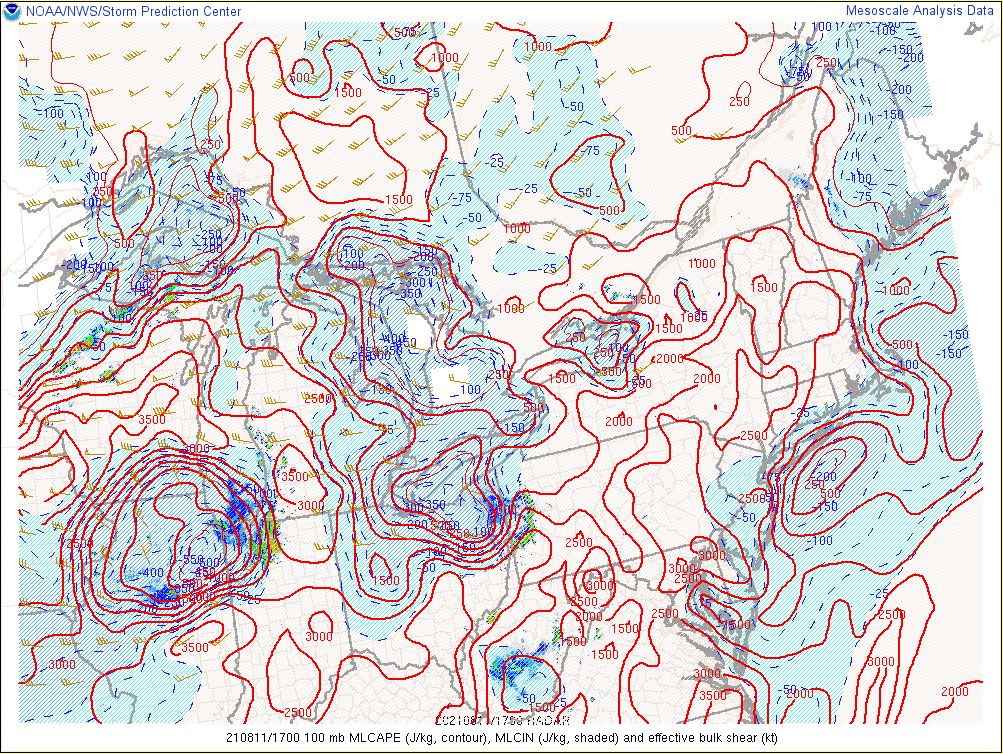
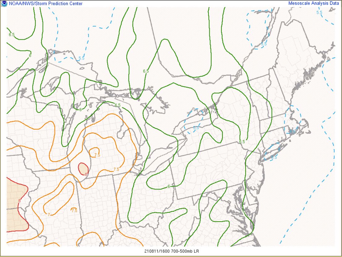
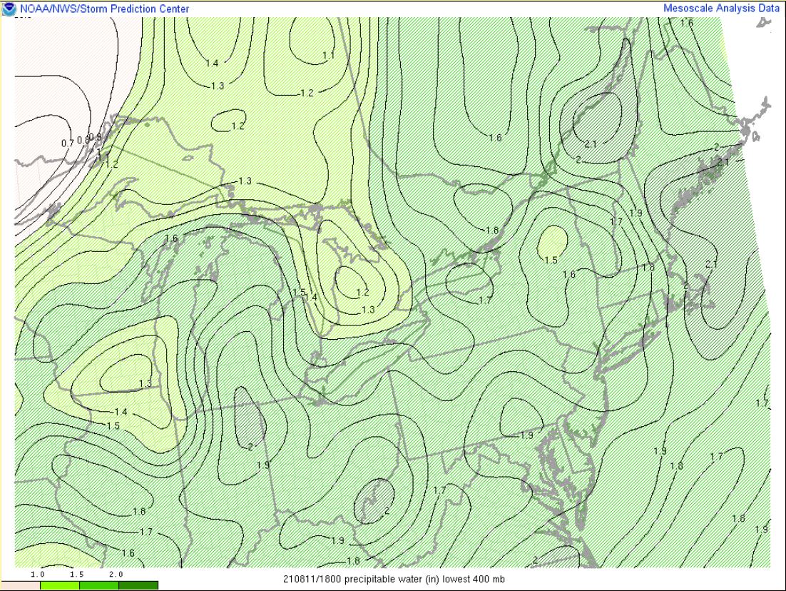
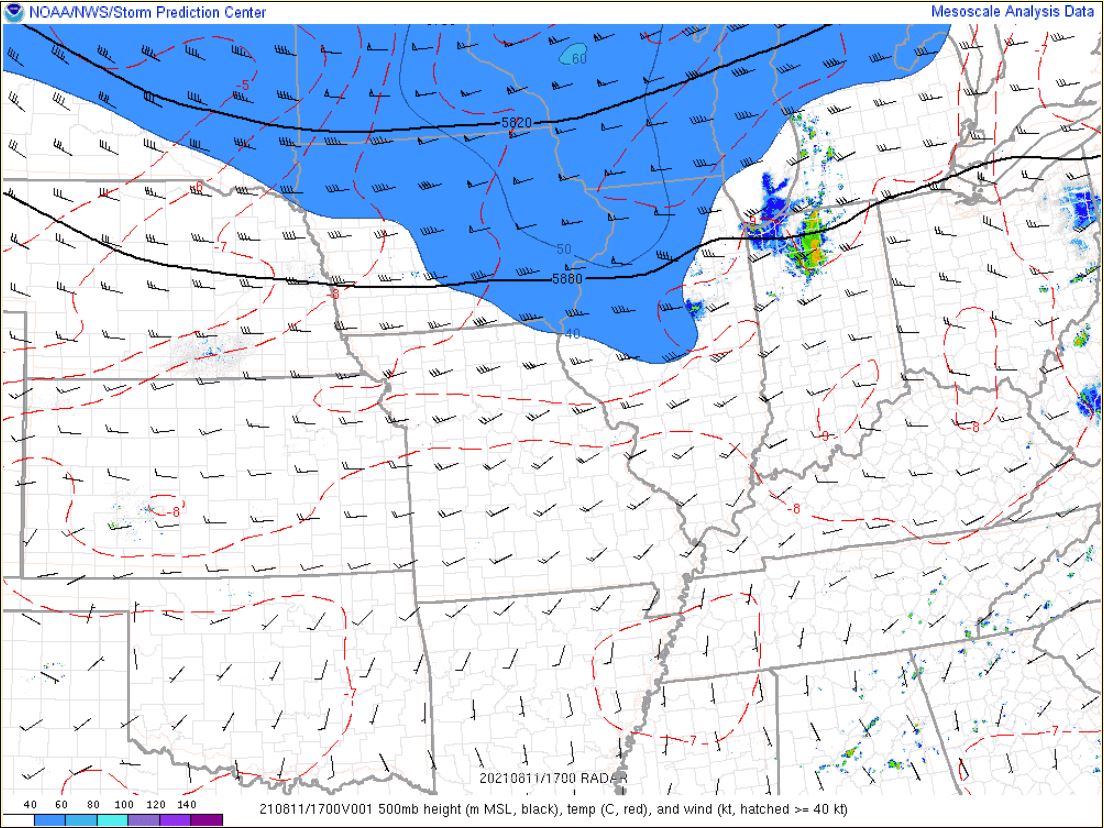
Conditions were favorable for severe storms, with plenty of moisture, lift, instability, and wind shear to work with. Figures 1 & 2 show the instability in the low and mid levels of the atmosphere. Figure 3 shows the available shear, which is usually a key ingredient for severe storm development. Upper level support (lift) was pretty weak, with a mid level shortwave (Fig. 5) and surface trough (Fig. 6) but given the high moisture content in the airmass (Fig. 4), and the ample instability, it was enough to kick off and sustain storms. To learn more about thunderstorm ingredients and lifecycle, check out our spotter training video here.
 |
 |
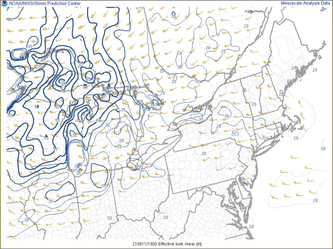 |
| Figure 1: Mixed Layer CAPE, CIN (J/kg) and Bulk Effective Shear (kts) at 1 pm EDT showing instability in the lower levels of the atmosphere (Image from SPC Mesoanalysis) | Figure 2: 500-700 mb Lapse Rates at 12 pm EDT showing instability in the mid levels of the atmosphere. (Image from SPC Mesoanalysis) | Figure 3: Bulk Effective Shear (kts) which is usually a key ingredient for severe storm development (Image from SPC Mesoanalysis) |
 |
 |
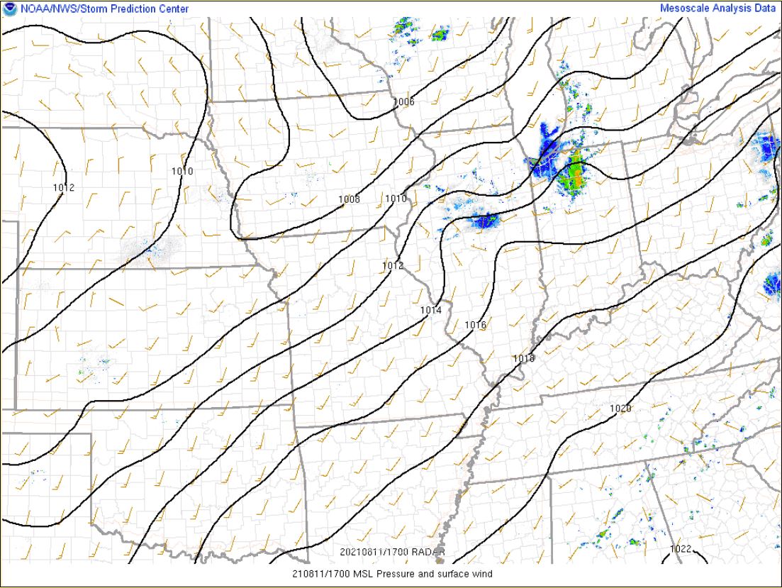 |
| Figure 4: Precipitable Water (in) of up to 2" at 2 pm EDT, which is around150-200% of normal for this time of year (Image from SPC Mesoanalysis) | Figure 5: 500mb height (MSL), Temp (C), Wind (kt) at 1 pm EDT. (Image from SPC Mesoanalysis) | Figure 6: Surface Pressure (MSL) and winds at 1 pm EDT. (Image from SPC Mesoanalysis) |
 |
Media use of NWS Web News Stories is encouraged! Please acknowledge the NWS as the source of any news information accessed from this site. |
|


.jpg)